Slapton Ley National Nature Reserve - Management Plan 2020 2030
←
→
Page content transcription
If your browser does not render page correctly, please read the page content below
Slapton Ley
National Nature Reserve

  Management Plan 2020 - 2030

               1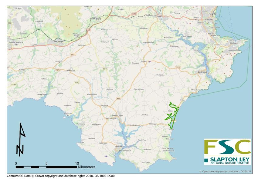
Contents
Contents ........................................................................................................................................... 2
Figures .............................................................................................................................................. 4
PLAN SUMMARY............................................................................................................................... 5
        Aims........................................................................................................................................... 5
        Vision ......................................................................................................................................... 5
A. GENERAL INFORMATION .......................................................................................................... 6
   1.      Legislation & policy/compliance ........................................................................................... 6
        1.1.      Relevant authorities ....................................................................................................... 6
        1.2.      Designations ................................................................................................................... 6
        1.3.      Tenure ............................................................................................................................ 7
        1.4.      Policies ........................................................................................................................... 8
        1.5.      Revenue and grants ....................................................................................................... 8
        1.6.      Health and safety rationale............................................................................................ 9
   2.      Site Description ................................................................................................................... 10
        2.1.      Location ........................................................................................................................ 10
        2.2.      External influences affecting management of the NNR .............................................. 11
   3.      Environmental information ................................................................................................. 13
        3.1.      Geology & soils ............................................................................................................. 13
        3.2       Hydrology ..................................................................................................................... 13
   4.      Habitat and species review ................................................................................................. 15
        4.1.      Coastal vegetated shingle ............................................................................................ 16
        4.2.      Freshwater lagoon and margins .................................................................................. 17
        4.3.      Terrestrial wetland communities ................................................................................. 22
        4.4.      Semi-natural broadleaved woodland .......................................................................... 26
        4.5.      Semi-natural lowland grassland and boundaries ........................................................ 29
        4.6.      Arable farmland ........................................................................................................... 30
        4.7.      Important plant & animal species................................................................................ 31
   5.      Stakeholders & engagement ............................................................................................... 36
        5.1.      Stakeholders ................................................................................................................ 36
        5.2.      Visitors ......................................................................................................................... 37
        5.3.      Volunteers .................................................................................................................... 42
        5.4.      Education use of Slapton Ley NNR ............................................................................... 42

                                                                            2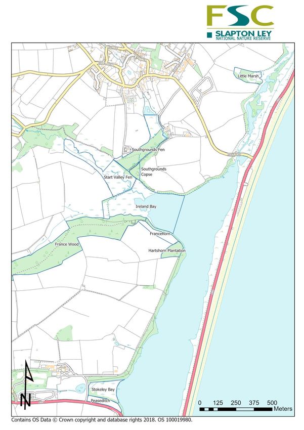
5.5.     Research at Slapton Ley NNR ....................................................................................... 43
B. CONSERVATION MANAGEMENT ................................................................................................ 44
   6. Habitat management: key habitats, associated species and management outcomes and
   actions......................................................................................................................................... 47
        6.1.     Freshwater lagoon ....................................................................................................... 47
        6.2.     Terrestrial wetland communities: reed swamp, tall herb fen and fen meadow ......... 49
        6.3.     Semi natural broadleaved woodland ........................................................................... 51
        6.4.     Semi natural lowland grassland and boundaries ......................................................... 53
        6.5.     Arable farmland ........................................................................................................... 55
        6.6.     Coastal vegetated shingle ............................................................................................ 56
   7.      Stakeholder management ................................................................................................... 59
        7.1.     Key stakeholders .......................................................................................................... 59
        7.2.     Education & volunteers ............................................................................................... 61
        7.3.     Infrastructure ............................................................................................................... 62
        7.4.     Health and safety and maintenance actions ............................................................... 63
References ...................................................................................................................................... 65
   Appendices ................................................................................................................................. 68
        Appendix 1. Reportable features for SSSI designation (Natural England) .............................. 68
        Appendix 2. Species lists ......................................................................................................... 69
        Appendix 3. Additional maps .................................................................................................. 72

                                                                         3
Figures
*Maps
Some maps are also available in Centre files
Title and link to section Page
Figure 1. The location of Slapton Ley NNR * 10
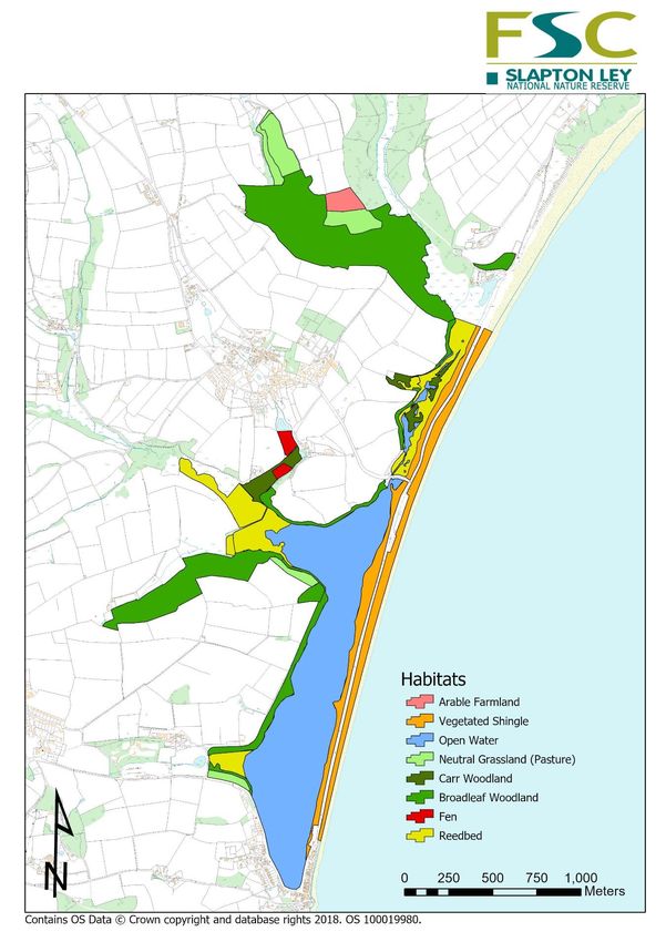
Figure 2. Main habitat types of Slapton Ley NNR * 15
Figure 3. Nitrates in mg/l from Higher North Mill and Deer Bridge 19
Figure 4. Strapwort numbers at three sites on the NNR 21
Figure 5. Breeding pairs of Cetti’s warbler on the NNR 23
Figure 6 A and B. The extent of NVC communities at Little Marsh * 25
Figure 7. Dormouse signs from nest box surveys 28
Figure 8. Total car park usage across all car parks 2010 - 2019 38
Figure 9. Car park usage over a 12 month period across years 39
Figure 10. Volunteer numbers and hours 2013 - 2017 39
Figure 11a-c. Reserve sites of active management * 43-45
Figure 12. Boundaries * 72
Figure 13. Public rights of way and access * 73
Figure 14. Place names mentioned in text (North). * 74
Figure 15. Place names mentioned in text (South). * 75
4
PLAN SUMMARY
Slapton Ley National Nature Reserve (NNR) has both national and regional importance for
wildlife and attracts many thousands of visitors each year for its wildlife, educational
opportunities, amenity and stunning landscape setting within the South Devon Area of
Outstanding Natural Beauty (AONB).
This management plan updates the previous 10-year plan and covers the period 2020 -2029. It
also provides the consent for management of the site from Natural England under Schedule 9
28E of the Wildlife and Rights of Way Act, as amended under the Countryside & Rights of Way
Act 2000.
The National Nature Reserve NNR agreement was originally signed in 1991, renewed from 1
April 2011 and expires in 2035. It is enabled by a policy document that relies on a management
plan agreed by all parties. The NNR signatories are Wild Planet Trust (formerly Whitley Wildlife
Conservation Trust until 2019), Field Studies Council FSC, Natural England NE and South Hams
District Council SHDC.

       Aims
The aims of this management plan are to provide a practical document for the implementation
of work programmes to meet key NNR objectives. These are to:
    1. Maintain and enhance the important habitats and species of the site to good condition
       whilst recognising climate change is likely to influence the status of some of these
       habitats.
    2. Demonstrate practical conservation management for educational purposes.
    3. Provide high-quality field sites for education and research in a safe and secure setting.
    4. Maintain and enhance public enjoyment of the site through good public access and
       visitor experience.
    5. Conserve the distinctive landscape character and spirit of place the site has.
    6. Place Slapton Ley NNR within the wider landscape setting and seek opportunities to
       influence environmental opportunities outside the reserve so that its intrinsic interest is
       not isolated and fragmented features.
    7. Provide relevant information to help inform the management plan.

       Vision
Slapton Ley NNR is a place where diverse habitats thrive; its network of wetlands and
woodlands are a sanctuary for wildlife and a place that continues to inspire successive
generations to engage with the natural world. The shingle ridge demonstrates how natural
processes have created the distinctive habitat inhabited by nationally-important plant and
invertebrate communities. The habitats and wildlife of the nature reserve remain at the heart of
what the Field Centre has to offer as an environmental education centre.

                                                5
A. GENERAL INFORMATION

This section A comprises the background and description pertaining to the site, which informs
the active management detailed in section B.

1. Legislation & policy/compliance

   1.1. Relevant authorities
Details of relevant authorities given in the table below.
Site name                        Slapton Ley NNR

Area (ha)                        NNR is 209.3 ha (also see other land holdings and boundaries
                                 beyond the NNR to which this plan pertains)
Grid ref (centre of reserve)     SX 826441

County Council                   County Hall, Topsham Road, Exeter, Devon EX2 4QD

District Council                 South Hams, Follaton House, Follaton Road, Totnes, Devon

Parish Councils                  Slapton; Stokenham; Strete

Parliamentary                    Totnes
Constituency
Environment Agency               Manley House, Kestrel Way, Exeter, Devon EX2 7LQ
office
Natural England                  Ground Floor, Stirling House, Dix’s Field, Exeter EX1 1QA

   1.2. Designations
Slapton Ley was designated as a Site of Special Scientific Interest (SSSI) in 2004 for the following
attributes for which it is nationally important:
Coastal geomorphology (shingle barrier beach enclosing a coastal lagoon), open water,
vegetated shingle, reed-bed, tall herb fen and fen woodland plant communities, an assemblage
of breeding birds of lowland open waters and their margins, a breeding population of the rare
Cetti’s warbler Cettia cetti, non-breeding passage birds, wintering bittern Botaurus stellaris, a
vascular plant assemblage, and a lichen assemblage. For a summary of the Natural England SSSI
condition report for the three units within the SSSI see the online information. The three units
were last assessed in 2010 as unfavourable recovering. For a list of reportable SSSI features see
Appendix 1.
                                                 6
Additional Designations
1. National Nature Reserve
2. Heritage Coast
3. Area of Outstanding Natural Beauty
4. Geological Conservation Review
5. Nature Conservation Review
6. Water Framework Directive (WFD)

   1.3. Tenure
Leasehold:
Sites owned by Wild Planet Trust and leased to the Field Studies Council (FSC). For place names
see figures 14 and 15 (maps).

 Site                             Area                              Date of Acquisition
 Slapton Ley                      191.37ha (472.68ac)               6 November 1956
 Rush Marsh                       Less than 1acre                   25 April 1967
 Frittiscombe Farm                3.3ha (8.14ac)                    13 July 1973
 South Parks Marsh (pt Slotts     0.82ha (2.02ac)                   22 Dec. 1980
 Farm)
 South Grounds Marshes            6.68ha (16.51ac)                  31 Jan 1978
 Ireland Cottage                  0.158 ha (0.39ac)                 12 February 1986
 Big Hill                         6.5ha (16.06ac)                   1988
 Little Hill
 Lower Summer Gaps                5.3ha (13.1ac)                    2004
 Hedgelands
 Peaseditch                       1ha (2.47ac)                      July 2018

Sub Leases. From FSC to South Hams DC from 2010
Sites owned by Wild Planet Trust
  Site                 Area                          Duration
  Shingle ridge        31.7ha (78.3ac)               25 years
                                                     Rent reviewed every 5 years
Sites owned by FSC
 Site                  Area                          Date of Acquisition
 Strete Gate           1.3ha (3.21)                  28 September 2017

Tenancies
Site                  Tenant             Area        Duration
Bird ringing hut      DEVON BIRDS        0.1ha       Ongoing - 6 months’ notice either side

                                                 7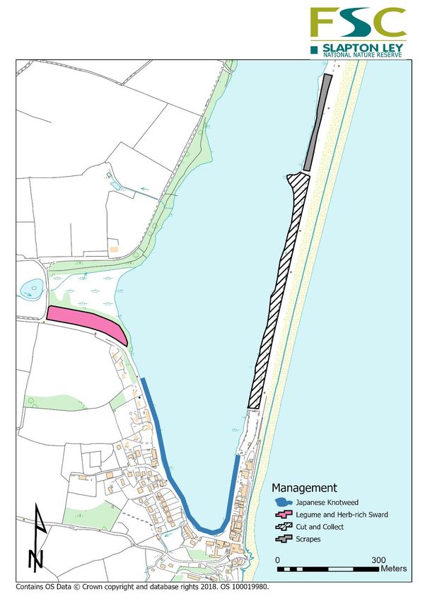
Licences
Licensor: The Official Custodian for Charities and the present Trustees of Wild Planet Trust and
the Field Studies Council.
 Land/right                Date         Licensee               Area        Term &
                                                                           review/expiry date
 Field No. pt1426          01/04/2004 B. Lethbridge            1.60ha      Current Licence
 Field No. pt1427          31/12/2004                                      Executed 22/04/04
 Grazing licence
 Hartshorn Ley side
 Fringes (Francehorn)

Land rights owned by Wild Planet Trust and part of NNR/SSSI
Land/right               Date           Tenant                Area        Term &
                                                                          review/expiry date
Slapton Ley NNR          2010           Field Studies         209.3ha     2035
                                        Council

   1.4. Policies
The policies of FSC are outlined in its Operational Codes of Practice (OCoP). There are a number
of OCoPs relating to the NNR, which are outlined below. These documents are available from
the SLFC shared drive ‘Badger’.
B04 Tree Safety
B12 Vehicles
B14 Use of boats on inland waters
E03 First aid provision
E09 RIDDOR
W07 Manual Handling
W08 Risk assessments for non-educational activities

   1.5. Revenue and grants
There are two main areas of funding for conservation of key habitats and species on the NNR: a
Countryside Stewardship grant scheme covering five years; and, mitigation funds from the
realignment of the road along the shingle ridge, as a result of storm damage in 2018 providing
funding for habitat and infrastructure work until 2029.

                                                 8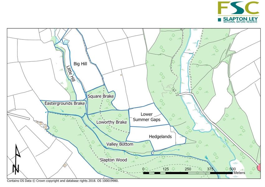
Source           Organisation     Dates          Area under      Comment
                                                  agreement
 Higher Level     Natural          2019-          Slapton Ley     See CS agreement for
 Countryside      England          2029           NNR 209.3ha     details of payments and
 Stewardship                                                      works.
 Scheme                                                           Funded works also
                                                                  included in work
                                                                  programme.
 A379 Road        Devon            Until          Various areas   See section 6 for details of
 Realignment      County           2023           on specific     where and what
 Mitigation       Council                         projects.       management the
                                                                  mitigation funds are used
                                                                  for.

   1.6. Health and safety rationale
Specific hazards & risks
   • Public access through woodland, coastal and wetland margins.
   • Algal blooms are an environmental health risk for visitors in late summer.
   • NNR infrastructure maintained in safe condition. Some liaison with DCC required.
   • NNR staff & volunteer use of tools, machinery & chemicals.
   • Use of boats by volunteers and staff for monitoring and survey work.
   • Educational use of boats by students and visitors.
   • World War 2 military ordnance on site. See External Influences.

The Field Studies Council OCOPs used to inform and guide all aspects of reserve work to
ensure a safe working environment
   • Safety assessment timetable created for nature trail and other public areas with regular
       checks and remedial work carried out within 2 weeks – to include regular risk
       assessment for timber visitor infrastructure.
   • Tree safety inspections completed annually and updated after storms (OCoP B04)
   • Safe use of machinery & record appropriately (OCoP B11)
   • Complete FSC Contractor Packs for all new contractors and update annually.
   • Events & activities risk assessed (OCoP L06P) & staff/visitor incidents recorded (OCoP
       E05)
   • Annually review lone working (OCoP W04), COSHH (B06), boats (OCoP
       B13&B14) & manual handling (W07).

                                              9
2. Site Description
  2.1. Location

  Figure 1. The location of Slapton Ley NNR

                                              10
2.2. External influences affecting management of the NNR
Factor Issue Strategies
Climate Change Higher sea levels, increased storm frequency and Managed retreat of coastline.
wave height are affecting the shingle ridge that No further road realignment.
separates the freshwater ley from the sea. Adaptation of habitats & Field Centre
A breach of the shingle bar would potentially affect activity.
the water levels and salinity of the freshwater ley Being ready & prepared to adapt to
and thus the nature conservation and infrastructure single storm events.
features of the site.
Plant Pathogens Several diseases/pathogens identified nationally Monitor for the presence of the disease
currently affect/might infect trees on NNR in the and report as necessary.
future. Fell diseased trees near highways/public
This would influence management of woodland/ rights of way
individual veteran trees that have a high nature Look to build resilience within
conservation/landscape interest. woodlands through selection,
Diseases/pathogens include: management and planting in the future.
Ash Die Back - a fungus and already present at
Slapton
Acute Oak Decline -stress related.
Sweet Chestnut Blight -a fungus recorded in Devon
2017.
Emerald Ash Borer -a beetle rapidly spreading
towards Europe.
Phytophthora ramorum – a fungus that causes
extensive damage and mortality to a wide range of
trees.
Military Ordnance Left over from the World War 2 and likely to be Limited excavation in ley and reed bed
present in Ley/reed beds/shingle bar. area, with MOD Ordnance Survey in
Timber in woodland areas is also affected by advance.
shrapnel and cannot be sold. Liaison with Coastguard & MOD for
public safety.
11Recreational pressures Increased dog walking and general visitor pressure Reduce trampling by use of fencing on
leading to disturbance to wildlife and trampling. the shingle ridge. Use of dead hedging to
limit access to sensitive areas.
Future Funding Increasing pressure on all funding sources. Commercial approach to maximise
Post-Brexit Review of Agri-Environment Schemes. sources of income where appropriate.
Devon County Council A379 Road Mitigation funding Meet funder requirements.
secured for 10 years. Continued efficiencies & savings.
Take opportunities for external funding,
e.g. private funders.
Water Quality Water quality of Ley is at risk from agricultural runoff Continue monitoring water quality.
from surrounding catchment, which affects the Work with landowners, statutory
nature conservation interest of site. organisations to ensure water quality
continues to improve.
Deer Increasing deer numbers affecting the woodland Monitor deer and any damage using
structure/herbs. exclosure plots.
Legal Obligations Cross Compliance (e.g. CS, SFP) Comply with all legal obligations.
Felling licences
Protected species
Health and Safety issues
Isolation and Fragmentation Slapton NNR needs to be part of the wider landscape Look to work with neighbouring
and not an isolated entity. Potential to connect to landowners and other agencies to create
other local habitats and landscape features. landscape scale connectivity.
Wild Planet Trust to purchase additional
adjacent land where possible.
123. Environmental information
3.1. Geology & soils
Important geology/geomorphology
The Lower Devonian Meadfoot group slates were laid down as silts and muds in a shallow
sea about 360 million years ago. The rock strata, as seen exposed at, for example,
Southgrounds Quarry, slope down to the margins of the Ley. Lower Devonian Dartmouth
group slates underlie the northernmost part of the Slapton Wood area. North of the Ley,
fragments of early fossil fish have been found in Dartmouth slates.
The shingle bar is an important example of a shingle barrier beach, and is described in the
Geological Conservation Review. It was formed in immediate post-glacial times by the
'Flandrian Transgression' pushing a predominantly flint and quartz shingle ridge onshore.
When this ridge joined the headlands at Strete (GR:845465) and Torcross (GR:823417) a tidal
freshwater lagoon was formed. The system is further described by Hails (1975). The ridge is a
geologically recent construct and it is to be expected that it will be dynamic, especially at a
time of rising sea levels (Royal Haskoning, 2007).
The first freshwater peats have been carbon-14 dated at 2,889 ±50 BP (ref. IX), though
marine incursions have occurred since then. The gentle, mostly vegetated slopes that were
the interglacial sea-cliffs form the landward shore of the Ley. These cliffs are now degraded
to heights not exceeding 10m (35 ft) above the height of the Ley.
The highest point of the reserve is at 98 m (325 ft.) ASL at Easterground Farm in Slapton
Wood.
Soils
The soils derived from Devonian slates are deep, and rich in silt and clay, a mixture which
makes them easy to cultivate except when they are wet. Where true soils exist (i.e. non-
alluvial) on the reserve they are of the brown-earth type, shallow and moderately acid (pH
5.0 - 6.5). Trudgill (1983) described the soils of Slapton Wood, which are acid (pH 3.8 - 4.6)
and nutrient poor with a high content of silt-sized particles and slate fragments.
3.2 Hydrology
The Slapton Catchment area is 46 km2 of agricultural land, largely pasture except where
arable dominates on the plateau. The catchment is sparsely populated with 4 settlements
and 2 Sewage Treatment Works (at Blackawton & Slapton). The major rivers and stream
draining into Slapton Ley have been gauged from the early 1970s to better understand the
causes of eutrophication of the Lower Ley. The largest is the River Gara with a gauged
catchment area of 23 km2. The Slapton Wood stream joins the Gara further downstream.
Whilst only 1 km2 in area, this basin is of some significance because of the detailed
hydrological research carried out there (Burt et al., 1983). The River Gara drains though the
Higher Ley (0.14 km2) to reach the Lower Ley; the Higher Ley is now largely reed swamp with
an open channel flowing through it, having been largely open water in 1945. The Lower Ley
(0.77 km2) comprises open water fringed by reed swamp or marsh; its maximum depth is 2.9
m. The Start (10.8 km2) and Stokeley Barton (1.5 km2) streams both drain directly into the
Lower Ley. The Lower Ley drains through a culvert at Torcross when the water level is high
13enough; otherwise, drainage is through the shingle ridge to the sea (van Vlymen, 1979).
A Diffuse Water Pollution Plan between Natural England and the Environment Agency was
created in 2010 (Natural England, 2010) and updated in 2015 (Natural England, 2015). This
summarises details of the catchment and includes the objective: Natural England and the
Environment Agency commit to work together to gather evidence and implement necessary
remedy measures as guided by this plan, in order to maintain an improving trend in nutrients
and sediment in the Slapton Ley catchment, so that SSSI condition targets are achieved in the
future
144. Habitat and species review
Figure 2. Main habitat types of Slapton Ley NNR
154.1. Coastal vegetated shingle
The ‘Shingle Ridge’ is a shingle bar of roughly 3.5km long, which stretches between Torcross
in the South and Strete Gate in the north, of which, 31.7ha sits within the boundary of the
NNR. Shingle is a globally restricted sediment type with few occurrences outside north-west
Europe, Japan and New Zealand. In the UK, shingle beaches are widely distributed around
the coast, but in most cases, they are within reach of storm waves and vegetation is unable
to establish making vegetated shingle a nationally and globally important habitat (Sneddon
& Randall, 1993). Increasing coastal erosion to the ridge crest continues to reduce the size of
this area of vegetated shingle habitat and visitor amenity (car parking and paths) due to
greater and more frequent storm events. We continue to work with stakeholders to adapt
our management of the road and mitigate the effects of previous road realignments on
these key features of the SSSI.
There are three zones of the shingle ridge, which run along the length of the bar: the
seaward face, the ridge crest and the ‘backslope’. Each zone has different abiotic conditions,
primarily due to the proximity to, and influence of the sea, giving rise to three distinct plant
communities:
The seaward face is a very high-stress environment and only the most pioneering plant
species are able to colonise, such as sea spurge Euphorbia paralias, sea kale Crambe
maritima and yellow horned poppy Glaucium flavum but even these species are only
abundant outside the boundary of the NNR at Strete Gate, where the beach is broader and
the gradient shallower. Along the majority of the shingle ridge, wave action and trampling
has resulted in the seaward face remaining largely unvegetated.
The ridge crest is the more species-rich area between the highly stressful, highly specialist
seaward face and the largely generalist communities of the backslope. It is stable enough
that vegetation has been able to establish but experiences enough disturbance, both natural
(storm events) and human (trampling) that it has retained its diverse, specialist plant
communities. Studies of exclosure plots have shown that while too much trampling damages
the habitat leading to unvegetated bare shingle, too little disturbance – such as that found in
established exclosure plots – results in a rank sward of coarse grasses, a decline of specialists
and a reduction in diversity (Silvester, 2005; Fletcher et al, 1987; Beeley, 1991). The best
examples of species-rich vegetated shingle are the 400m south of Strete Gate and 800m
stretch south of the memorial car park. These sections of the ridge crest are broad enough
that any footfall is spread across a wider area. In these areas, where a grass sward exists, it is
primarily short, Festuca rubra, alongside a diverse community of forbs including viper’s
bugloss Echium vulgare, wild carrot Daucus carota, sea mayweed Tripleurospermum
maritimum, sea campion Silene uniflora, rest harrow Ononis repens, broomrape Orobanche
sp. and rough clover Trifolium scabrum.
Unfortunately, this most valuable habitat is also the most threatened. A number of large
storm events (e.g. 2001, 2014 and 2018) have reduced the area of the ridge crest. A
reduction in area risks concentrating the trampling pressure, damaging what is left and with
climate change, it is likely that these large storm events might become more frequent.
The backslope is grassland dominated by a species-poor community of false oat grass
Arrhenatherum elatius, red fescue Festuca rubra and sea radish Raphanus raphanistrum ssp.
maritimum and a combination of scrub communities containing blackthorn Prunus spinosa,
gorse Ulex europaeus and sycamore Acer pseudoplatanus. This species-poor MG1a grassland
has replaced a more species-rich, Festuca rubra-dominated turf in the absence of grazing by
sheep (pre-war) and probably maintained by rabbits until the 1950s. There are still remnants
16of the Festuca rubra-dominated community, but it is becoming increasingly rare (Wilson,
2002). These shifts have also resulted in the loss of several rare species of lichen in the genus
Cladonia (Dobson & Hawksworth, 1996). The scrub communities that have developed now
sustain important populations of Cetti’s warbler Cettia cetti, cirl bunting Emberiza cirlus,
linnet Linaria cannabina and dormouse Muscardinus avellanarius.
Invertebrates
As well as its plant community, the shingle ridge is nationally important for its invertebrate
assemblage, containing a range of red data book and nationally scarce invertebrates as well
as many species of regional and county importance. The majority of these are found
associated with the bare shingle at the strandline and the sparsely vegetated ridge crest, the
backslope being of only local/regional importance (Alexander 2004).
Of particular importance for invertebrates is the ca. 800m stretch of ridge crest south of the
middle car park. This area is valuable because of its combination of bare ground, short
species-rich sward and rank tussocky vegetation. It is likely that the presence of the
exclosures here and the resulting pattern of footfall has created a mosaic of optimal
structural diversity. Here the importance of bare ground created by trampling should be
stressed (Boyce, 2017).
While the continuing good management of the ridge crest is important in retaining the
botanical and invertebrate interests, considering the increasing magnitude and frequency of
storm events, better management of the backslope (through scraping, cutting or grazing) is
the only way to ensure their long-term conservation.
4.2. Freshwater lagoon and margins
The freshwater lagoon of Slapton’s Lower Ley, at 66ha, is the largest freshwater lake in
South West England. The catchment of Slapton Ley is 4,560ha, which can be divided into
four main drainage basins: the Gara (2,680ha), which is the largest catchment and enters the
Ley from the north; Slapton Wood stream (122ha) joins the Gara at the northern boundary
of the NNR; Start stream enters the Lower Ley at Ireland Bay; Stokeley Stream (1.67ha)
enters the Lower Ley at the South near Torcross. There is a further 3.08ha of minor drainage
basins.
Succession
The natural succession of the wetland habitats has been proceeding at different rates over
the last 1000 years (Cannell 1992). Most recently, the creation of the toll road along the
shingle ridge in 1886 and the raising of the Torcross sluice in the 1920s have combined with
massive agricultural ‘improvement’ by ploughing and fertilising in the catchment to cause
very high rates of sedimentation and eutrophication.
Water quality
The water quality of Slapton Ley is the single most important ecological driver. It affects the
species composition of the plants, invertebrate, fish and birds. It has been very well
documented, with a continuous dataset as far back as 1982. The nutrient status of the Ley
began to deteriorate in the 1940s (accelerating in the 1960s) and sedimentation has
progressed at pace. There are a number of sources of nutrient pollution including sewerage
systems, primarily Blackawton sewage treatment works, which discharges into the Gara;
septic tanks; agriculture; avian faeces and ‘internal loading’ which refers to the release of
nutrients stored in the sediment (Dobson et al, 2015).
17A combined effort from a number of organisations including Natural England, Environment
Agency and Westcountry Rivers Trust has resulted in a significant improvement in water
quality coming from the catchment (figure 3). Despite this long-term trend in water quality,
current concentrations of various pollutants remain higher than the relevant targets to
achieve ‘good’ status under Water Framework Directive (WFD) targets (also see targets in
section 6.1). It is believed that this is due to internal loading and that there could be a lag
time of decades before improvements in catchment input are seen in the Ley.
A result of the eutrophication of the Ley is the periodic occurrence of algal blooms; species
of Cyanophyceae include Microcystis flos-aquae, Anabaena circinalis, Anabaena spiroides
and Gloeotrichia echinulate. The impacts of algal blooms at Slapton Ley are both human and
ecological. The toxicity of some species of Cyanophyceae represents a health risk to visitors,
their pets and livestock as well as restricting the teaching opportunities. The main ecological
impact is to shade out the macrophytes on which much of the ecosystem is dependent,
including wintering wildfowl.
1814.00
12.00
10.00
8.00
6.00
4.00
2.00
0.00
Gara Start Linear (Gara) Linear (Start)
Figure 3. Nitrate concentrations in mg/l NO3-N from Higher North Mill (representing the Gara catchment) and Deer
Bridge (representing the Start catchment).
19Plants
A number of important species of aquatic macrophyte have been recorded in the Lower Ley
since the first major botanical survey was carried out by Brookes and Burns (1969). The change
in species over this period shows a shift from mesotrophic to eutrophic conditions (Johnes and
Wilson, 1996), a trend that has been well-documented in other literature. A species of
conservation importance that is still present is the stonewort, Chara connivens, which is
monitored as part of the annual macrophyte survey. This survey focuses on the relative
abundance of Elodea spp., Potamogeton spp, C. connivens and filamentous algae. See appendix
2 for species list of key macrophytes.
An important plant species to the NNR is Strapwort Corrigiola litoralis; Slapton Ley was the only
known site for this species until it was reintroduced to Looe Pool (2015-2020) from seed
collected from the Slapton NNR. It is a small prostrate annual with glaucous leaves and tiny
white flowers. It grows on the edges of lakes and large rivers that have significant seasonal
fluctuations of water level. It relies on the bare substrate exposed as water levels drop in the
summer; disturbance by cattle (or people) exposes buried seed and helps prevent colonisation
by perennials, which very quickly outcompete this light-demanding plant.
Historically, it was very widespread around the ley fringes when livestock had free access to the
water but over the course of the 20th century these areas have declined: the backslope has not
been grazed since before World War 2; Southgrounds shore has been fenced off for visitors
since the site has been a nature reserve and a buffer strip of trees was planted along America
Road in the 1970s to improve water quality. This has led to vegetation colonising the vast
majority of the shoreline until Strapwort was confined to a single site at the boat mooring,
where bare ground was maintained by visitors, boat users and students; however, it never
thrived there due to the effect of excessive trampling during the growing season.
There have been a number of attempts to restore the population: in the 1990s cattle access was
reinstated along the nature trail using livestock from Southgrounds Farm but there were
concerns about the safety of visitors. Subsequently cattle access was removed from
Southgrounds shore.
Wild Planet Trust have been heavily involved in the project and have propagated seed at
Paignton Zoo and plug-planted to supplement falling numbers (2006 - 2011), and from 2014
Natural England has provided funding through the Species Recovery Programme. Towards the
end of the 2010-2019 management plan, success was achieved using diggers to create bare
ground, grub out trees and reprofile the shoreline. In 2017 this technique yielded good results
at Hartshorn and again in 2018 at the boat mooring (see figure 4); in these instances, there was
no propagation and plug planting required. In these areas, bare ground is maintained by cattle
access (Hartshorn) and manual clearance (boat mooring).
202500
2000
1500
Southgrounds
1000
Boat Mooring
500 Hartshorn
0
Figure 4. Strapwort numbers at three sites on the NNR showing success of two interventions:
plug planting in 2010 and 2011 and bare ground creation / re-profiling in 2017 and 2018.
Birds
Two of the SSSI features for the NNR relate to birds: breeding birds and ‘non-breeding passage
and wintering’. The breeding bird assemblage of the Lower Ley includes gadwall Mareca
strepera, mute swan Cygnus olor, tufted duck Aythya fuligula, coot Fulica atra, pochard Aythya
ferina and great crested grebe Podiceps cristatus. The band of reed that fringes the ley is
important for passage migrants including hirundines and warblers. Wintering birds include
wigeon Mareca penelope, goldeneye Bucephala clangula, little grebe Tachybaptus ruficollis and
occasionally teal Anas crecca, black-necked grebe Podiceps nigricollis and shoveler Anas
clypeata.
Invertebrates
Slapton Ley is considered a nationally important site for its dragonflies (Stevens, 1998), with 18
18 species of Odonata at Slapton Ley, 12 of which were confirmed or presumed to be breeding.
Fish
Slapton Ley contains primarily perch Perca fluviatilis, pike Esox lucius, roach Rutilus rutilus and
rudd Scardinius erythrophthalmus. Historically, it was known as one of the best locations in the
country for pike. The fish populations of Slapton are well documented thanks to decades of
angling returns; data from between 1970 and 1995 were analysed by Kennedy (1996), in which
he was primarily concerned with the population dynamics of roach and rudd in the presence of
21the tape worm Ligula intestinalis, which parasitizes roach. During the 1960s, eutrophication
reached a level that resulted in an expansion of roach, reversing the historic dominance of rudd
and leading to a reduction in the size of pike and roach. The abundance of small fish attracted
large numbers of breeding great crested grebe. With the grebes came L. intestinalis, this
decimated the unhealthy and stunted roach population, after which the rudd population
recovered and the grebe numbers declined. This cycle has continued ever since, punctuated by
episodes of winterkill and hyper-eutrophication. This cycle is evident in the grebe population,
which exhibits a boom and bust dynamic, mirroring that of the roach.
4.3. Terrestrial wetland communities
The NNR contains a wide diversity of wetland communities and associated wildlife. The majority
of these communities exist where the rivers and streams level out and join the open water; the
more botanically interesting and diverse areas tend to be those which have historically been
managed by cutting or grazing, such as Little Marsh and Southgrounds.
Swamp Communities
A major swamp community is reed swamp (S4), which is a relatively species-poor community
botanically but one which has important associated fauna. The NNR contains roughly 22ha of
reed swamp excluding the reed fringing the ley; the main blocks of reedbed are at Ireland Bay
and the Higher Ley with a smaller reedbed at Stokeley Bay. The Higher Ley is a mosaic of
reedbed, open pools and carr woodland. It was open water as recently as recently as 1900 but
through the process of sedimentation, which accelerated from the 1960s, it developed into a
reedbed community; it is now considered a dry reedbed cut bisected by a fairly distinct channel.
The second major block of reed is at Ireland Bay, which starts near Deer Bridge, where it
transitions up the valley into carr woodland, and stretches towards the Lower Ley, where it
transitions into open water. North of The Causeway it exists in a complex of other swamp
communities and willow scrub but below The Causeway it is a fairly uninterrupted reedbed. It
also extends some way up the valley of France Wood. Until 2005, the reedbeds were managed
through a combination of cutting and burning. The large block of reed at Ireland Bay was
managed with burning and a number of blocks were cut on rotation, including at Little Marsh,
south of the Causeway, north of Slapton Bridge.
There are a number of important reedbed species at Slapton Ley. Arguably the most important
is Cetti’s warbler; with between 35 and 45 breeding pairs (see figure 5) the NNR contains
roughly 2% of the UK population making it a nationally important site for the bird. It is also the
only individual breeding bird listed as a SSSI feature. The population is most dense in the Higher
Ley, where the combination of reed, open water and scrub is optimal, however, they are also
found at Ireland Bay, Stokeley Bay and the narrow strip of reed around the fringe of the ley.
Management objectives that benefit Cetti’s have involved rotational scrub cutting on the
backslope to maintain extent and structure.
2270
60
50
40
30
20
10
0
Confirmed territories Possible territory
Figure 5. Breeding pairs of Cetti’s warbler on the NNR; stable and fluctuating around 40 pairs.
Another SSSI feature is the non-breeding and passage bird assemblage; within this feature, the
species relevant to reedbed are bitterns Botaurus stellaris and starlings Sturnus vulgaris.
Bitterns have been known to use Higher Ley and Ireland Bay. They have a preference for wetter,
early successional reedbed and while their winter habitat preference is less demanding than for
breeding it is likely Higher Ley has, and will continue to become less suitable for bittern. Large
numbers of starlings – up to 100,000 – roost in the reedbed from October. The Higher Ley also
contains good numbers of warblers including reed warbler Acrocephalus scirpaceus, sedge
warbler Acrocephalus schoenobaenus, whitethroat Sylvia communis, blackcap Sylvia atricapilla
and garden warbler Sylvia borin as well as reed and cirl bunting Emberiza cirlus. There are
around 10 pairs of water rail Rallus aquaticus across the reserve, with highest numbers at
Higher Ley.
Another swamp community on the NNR is sedge swamp dominated by greater tussock sedge
(Carex paniculata), which is the second most common swamp community after reed bed-
swamp dominated by common reed (Phragmites communis). It occupies parts of the Higher Ley
as well as parts of the Start Valley bottom between Deer Bridge and Ireland Bay Causeway. This
community is a species-poor community and associated with slow-moving eutrophic water
(Bennett 2011a).
North of the causeway (Start valley fen) is a complex of swamp communities including those
dominated by common reed Phragmites australis, marsh bedstraw Galium palustre, Bulrush
Typha latifolia water mint Mentha aquatica, branched bur reed Sparganium erectum and marsh
speedwell Veronica scutellate. “The rich diversity of swamps around the Causeway reflects a
healthy abundance of water. Even so, the four swamps that have been identified are all
23represented by their most diverse sub-community - an indication that succession is progressing
towards communities of progressively drier habitats.” (Ros Bennett, 2010).
Tall herb fen
Tall herb fen communities are rare on the NNR and the only location where it is truly
represented is Little Marsh. Little Marsh contains four main communities: Phragmites australis
swamp (S4), willow carr (W2 or W5 depending on whether you look at the tree species or
ground flora) and two tall herb fen communities (S24 and S26). The tall herb fen communities
are found around the edges of the marsh where the waterlogged reed swamp transitions in the
drier farmland. During the 70s much of Little Marsh would have been the species-rich S24
community. “This community, in its purest state, reflects a healthy habitat that receives plenty
of un-enriched fresh water to provide a moderately high summer water table (at 0 to - 30cm
below) and some winter flooding” (Bennett, 2011). It was maintained by grazing when the
livestock from the surrounding farm had free access to the marsh but a fence was erected in the
1990s or 2000s and grazing was halted. As a result, the S24 community has developed through
succession into either the species-poor tall herb fen community S26 or the tall weed community
OV26 (Bennett, 2011; see figure 6). A report was written in 2011 recommending that
management be reinstated in order to restore the habitat and as a result a fence was installed
to protect the boardwalk and newly planted woodland. In 2017 reed cutting was reinstated and
in 2018 grazing was returned with the permission of the landowner and grazier.
24A
B
Figure 6. A: The extent of NVC communities at Little Marsh in 2011. B: the
potential extent of the species-rich S24 community following recommended
grazing regime (Bennett, 2010).
25Fen Meadow
Slapton Stream is one of the minor drainage basins, which runs through Slapton Village and
joins the Start Stream north of the Causeway. It flows into a large pond just south if the village
before it levels out and forms the flat waterlogged habitat of the Southgrounds fen meadows. It
is an L-shaped fen complex 500m long and 70m wide. It contains a fen meadow (Southgrounds
upper fen) that has been managed through a cutting regime for a decade or so, which contains
a good diversity of plants, invertebrates and amphibians. A barbastelle bat Barbastella
barbastellus was recorded along the footpath towards the village in 2018, which suggests it may
be used as a foraging habitat for this very rare BAP species. It also contains southern marsh
orchid Dactylorhiza praetermissa. There are another two areas of unmanaged fen meadow
within the Southground/Start stream basin, which contains a fairly homogenous stand of
hemlock water-dropwort Oenanthe crocata and horsetail Equisetum spp. as well as few other
species including southern marsh orchid Dactylorhiza praetermissa.
The Causeway Mire
Along Ireland Bay Causeway there are remnants of M28a Iris pseudacorus-Filipendula ulmaria
mire: Juncus sub-community containing yellow flag iris Iris pseudacorus, meadowsweet
Filipendula ulmaris and marsh skullcap Scutellaria galericulata. This attractive and diverse
community was once widespread along the causeway and across the marsh to France Wood. It
is maintained by cutting and has declined in character and extent since this management has
been scaled back. It used to be present along the route of the boardwalk but since it was
installed, regular cutting and removal of the vegetation stopped (though some characteristic
species such as ragged robin Lychnis flos-cuculi are still present).
4.4. Semi-natural broadleaved woodland
Slapton Wood
Slapton Wood is a 28ha ancient broadleaved woodland. It occupies a 1.5km section of the valley
of Slapton Wood Stream at its confluence with the Gara. It is broken up into a number of
compartments, some of which are relatively recent secondary woodland on abandoned fields
and others are plantations of beech Fagus sylvatica and sweet chestnut Castanea sativa. There
is roughly 18ha of Slapton Wood on the southern valley-side which is considered ‘ancient’; this
section contains a high proportion of oak (predominantly Quercus petrea) relative to other
compartments and has a ground flora indicative of ancient woodland, including bluebells
Hyacinthoides non-scripta, wood anemone Anemone nemorosa, opposite-leaved golden
saxifrage Chrysosplenium oppositifolium, wood sorrel Oxalis acetosella, great wood-rush Luzula
sylvatica and several fern species. The presence of the sunken Wood Lane linking the wood to
Slapton Village also hints at its long history. There is an area around the Keeper’s Cottage and
the turning circle where oak is dominant in the canopy, but by far the most abundant canopy
species throughout the wood is sweet chestnut. There is more or less ubiquitous hazel corylus
avellana and/or holly ilex aquifolium understory. Kitchin (1983) shows that there is almost no
oak regenerating in Slapton Wood. Sycamore acer pseudoplatanus and to a lesser extent sweet
chestnut are the species that fill canopy gaps following wind-throw. It appears that sweet
26chestnut is more susceptible to wind-throw than oak. There are some compartments where beech dominates, such as at Eastergrounds and an area of Loworthy Brake, which we can assume were plantations. The nature of the southern valley-side is of a mature, high canopy, damp and cool woodland. The northern valley-side has a different character: it is not considered ‘ancient’, indeed some compartments, i.e. Valley Bottom, Eastergrounds Brake and Square Brake are abandoned fields which are little older than 100 years (Kitchin, 1983). Contrary to the report by Kitchin (1983), Loworthy Brake is substantially older than these other compartments, appearing, as woodland, on maps from 1887, where the others are still showing as fields. Most trees in Loworthy Brake were planted at the turn of the century but differences in age suggested there had been natural regeneration since then; it can therefore be assumed that Loworthy was at some stage felled and replanted. The abandoned fields contribute to the structural diversity within Slapton Wood, containing low, dense, scrubby areas of blackthorn prunus spinosa, bracken Pteridium aquilinum and bramble Rubus fruticosus, which contrast the mature high forest of the southern valleyside and Loworthy Brake. Management in Slapton Wood has been fairly minimal: previous management regimes have carried out some coppicing at Loworthy Brake, while more recently (until 2020) low-level sycamore removal has been carried out in the ancient woodland compartments. Mammals At least 12 species of bat have been recorded in and around Slapton Wood including both horseshoe species (greater horseshoe bat Rhinolophus ferrumequinum and lesser horseshoe bat Rhinolophus hipposideros), both long-eared species (brown long-eared bat Plecotus auritus and grey long-eared bat Plecotus austriacus) and Bechstein’s bat Myotis bechsteinii. In 2018 common or hazel dormice Muscardinus avellanarius were recorded in Slapton Wood for the first time in Loworthy Brake and Square Brake. Fungi and lichens The Slapton Fungal Survey has involved at least 64 mycologists since 1969; Dobson and Hawksworth (1996) reported that there had been 2,344 species of fungi have been recorded (including lichenised fungi, slime molds etc.) with 21 new to science. They estimate the total number to be 3000. Hawksworth’s paper (1986) included an index of ecological continuity (NIEC), which provides an indication of the ecological continuity of mature deciduous trees based on old-forest indicator lichen species (the index is 0-100,
cliff trees and Marsh Lane from Deer Bridge to Ireland Bay.

There are very few records of bryophytes for the site, which is a gap in the data; this is an area
for future survey efforts.

France Wood
France Wood is a secondary woodland dating back to the 18th century. It is a mix of broadleaved
species including sweet chestnut, oak, ash Fraxinus excelsior, sycamore, hazel and holly. It has
been subject to a ‘100 year plan’, which originally involved felling and replanting but that
changed to allow natural regeneration. This was halted for the 2020 plan.

Southgrounds
Southgrounds copse is a 0.5ha compartment containing a diverse mix of trees and shrubs
including hazel, elm Ulmus sp., oak, sycamore, sweet chestnut, birch Betula pendula, cherry
Prunus avium, holly and spindle Euonymus europaea as well as herbaceous ancient woodland
indicators including moschatel Adoxa moschatellina and primrose Primula vulgaris. Dormice
have been monitored at southgrounds for many years as part of the National Dormouse
Monitoring Programme and has seen numbers declining from a high of 15 in 2005 to zero in
2012 (see figure 7). One potential cause that has been suggested is disturbance by dogs; in
response to this, a combination of hedge laying and dead hedging along the path started in
2017. The site is linked along the Nature Trail to a known dormouse population at Slapton
Bridge so it is thought that when the situation improves, dormice might return.

 35

 30

 25

 20

 15

 10

  5

  0

                            Southgrounds         Backslope N        Backslope S

 Figure 7. Dormouse signs (dormouse or nest present) from nest box surveys at Southgrounds
 copse, and the backslopes of the shingle ridge.

                                                28
4.5. Semi-natural lowland grassland and boundaries Loworthy fields consist of two areas of grassland that were acquired by Wild Planet Trust in 2004. Hedgelands (3.18ha) and big hill (4.45 ha); (also referred to as big hill/ little hill). The lowland grassland habitat is found in these two areas, which are separated by part of Slapton wood (Loworthy Brake). Big hill is south west facing with scattered scrub, mainly gorse and bounded by woodland, hedgerow and stock fencing. Hedgelands is south facing, sloping down to Slapton wood. These fields are part of the land holdings of Wild Planet Trust but are situated outside the NNR and SSSI boundaries. This parcel of land also includes an area of rough grassland/scrub and arable land (totalling approx. 2.4 ha), see section 3.6 Arable Farmland (Lower Summer Gaps). In 2010 it was formally included in the lease to Field Studies Council, and consequently the Slapton Ley NNR Management Plan and Higher Level Stewardship Scheme. On acquisition, these fields had a recent management of improved pasture. The management aim for big hill and hedgelands was to increase floristic diversity through the reintroduction of grazing with no fertiliser additions. Four soil scrapes were excavated in hedgelands in an attempt to reduce soil fertility (particularly phosphate) in these experimental plots. Due to the aspect and location of these fields they were also considered as possible sites for an introduction of the large blue butterfly Phengaris arion. Surveys of the ant populations by the University of Sheffield (Guillem, Drijfhout and Martin, 2012) showed the presence of Myrmica sabuleti, the required host for the larvae of the large blue and two fenced plots were erected (big hill) to introduce common thyme Thymus polytrichus, the other larval requirement. These activities occurred alongside various attempts to graze the sites, firstly with Dartmoor ponies (2006) and subsequently using a neighbouring grazier’s sheep. The grazing prescriptions for the large blue are a short (
the case if using sheep, which will preferentially select certain plants, resulting in an overall
reduction in floristic diversity. The historic, extensive grazing by few elderly sheep over
prolonged periods has not been beneficial.
Another beneficial management tool would be to take a late summer hay cut followed by
aftermath grazing in autumn. This is problematic due to the steep nature of the site making
bailing difficult.
Notable species using the grassland are cirl buntings, which nest in the surrounding hedges. The
development of invertebrate-rich grassland is key to supporting the summer nesting birds.
Dormice occur in the adjacent areas of Loworthy Brake and likely also use the connecting
hedgerows.

   4.6. Arable farmland
Lower Summer Gaps consists of two arable fields (1.8ha) separated by a hedge, planted when
the land was acquired. The land is managed primarily for the benefit of cirl buntings, specifically
wintering cirl bunting, as their diets shifts from insectivorous during the summer to granivorous
in the winter. Typically, spring cereal crop (containing millet, barley etc.) is sown in April; for
many years this was topped in autumn but this practice was halted in 2017 as there was no
evidence it had any benefit. Originally, the two fields were alternated, each having a fallow year,
but this was changed so that both fields were managed every year. The number of cirl buntings
using these fields during the winter has steadily increased, which suggests a growing population
within the wider landscape. The arable plant community has never been investigated but this
could be another priority feature.

                                                30
4.7. Important plant & animal species
4.7.1. Plants
See Brookes and Burns (1969) for an account of the flora and list of vascular plants. Over 490
species of vascular plant have been recorded, as well as 197 species of mosses and liverworts.
Species Status Comments
Strapwort WCA 8 & RDB One of only two sites in UK.
Corrigiola litoralis (Critical))
Prickly Sedge RDB (CR) New survey needed to establish
Carex muricata ssp. muricata status.
Three-lobed Water Crowfoot RDB (V) New survey needed to establish
Ranunculus tripartitus status.
Convergent Stonewort RDB (Endangered) Noted as rare in 2018 survey.
Chara connivens
An aquatic macrophyte RDB (V) Only site in Devon.
Ceratophyllum submersum New survey needed to establish
status.
Many-fruited Beardless-moss RDB (CR) New survey needed to establish
Weissia multicapsularis status.
Cryptolechia carneolutea RDB (V) Lichens surveyed by NE, most
recently 2012
Parmelina quercina RDB (V) New survey needed to establish
status.
Southern Grey RDB (E) New survey needed to establish
Physcia tribacioides status.
Golden-hair Lichen RDB (V) New survey needed to establish
Teloschistes flavicans status.
314.7.2. Birds
BOCC and other key species related to Slapton habitats
UK population figures taken from British Birds 2013- Musgrove et al.
Wildfowl population estimated using standard BTO field survey protocol- full survey in 2012.
BOCC – Birds of Conservation Concern BAP – Biodiversity Action Plan
SPEC – Species of European conservation concern
BREEDING BIRDS
Species Population Size Status Comments
Cetti's warbler 38 territories (2018) SSSI Feature 1.8% of UK population
Cettia cetti (2009).UK population now over
2,000 prs. SSSI feature figure
from 2009 should be amended.
Cirl bunting 3prs (2018) Up to BAP priority Breeds around reserve -
Emberiza cirlus 6prs have bred and numbers have increased.
wintering population
25 birds 2017/18.
Linnet Nesting in various BAP Priority Added to Red list in 2010
Linaria cannabina places but pop’n size
unknown
Aquatic warbler Passage only Globally Site may be important staging
Acrocephalus threatened post on migration. However,
Paludicola Rarely seen.
Garganey 1 pair 2013 SPEC Irregular nesting
Spatula querquedula BAP priority
Tufted duck Max summer count - SPEC 2012 survey
Aythya fuligula 53 birds (2018)
Max. winter count-
321(2018)
Little Egret 1 pair BAP priority Nested 2011 - possibly still
Egretta garzetta breeding in heronry
Reed bunting c.8 prs BAP priority Last count 2005
Emberiza schoeniclus
32You can also read