Upper Collie Water Management Plan Issue Scoping Report - Beckwith Environmental Planning Pty Ltd
←
→
Page content transcription
If your browser does not render page correctly, please read the page content below
Upper Collie Water Management Plan

          Issue Scoping Report

   Beckwith Environmental Planning Pty Ltd
                 Prepared for

           Department of Water
      Government of Western Australia
                  June 2007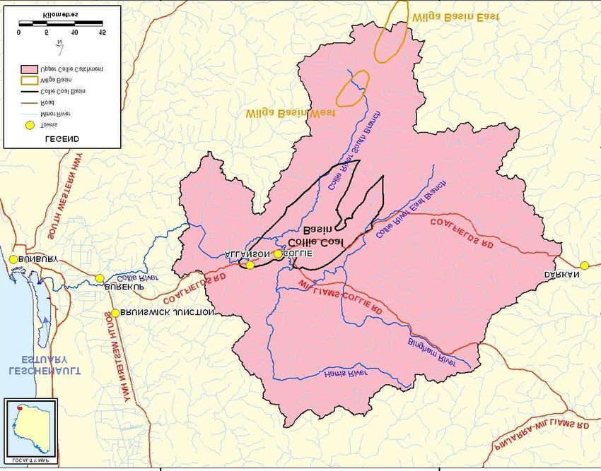
Acknowledgements
The authors would like to thank all of the individuals and organisations who generously
agreed to meet and share with us their knowledge and insights on the Upper Collie
Catchment, the Collie Coal Basin and the water management planning process.

The support of both the Perth and Bunbury Offices of the Department of Water are
appreciated. We extend a special thank you to Jessica Scott, Trudy Evans and Brendan
Kelly for their assistance with this study.

Sincerely,

Jo Ann Beckwith PhD
Director
Beckwith Environmental Planning Pty Ltd
www.beckwith-associates.com

Report authorship

This document is the property of Beckwith Environmental Planning Pty Ltd. The opinions
and recommendations in this report are those of the authors and do not necessarily reflect
Department of Water policy or positions. Any questions or comments regarding this report
should be directed to Dr Jo Ann Beckwith, Director, Beckwith Environmental Planning
Pty Ltd via email jbeckwit@bigpond.net.au or phone (08) 9450 8711.

Any questions regarding the Department’s work in relation to the Upper Collie Catchment
should be directed to Ms. Jessica Scott, Project Manager, email
jessica.scott@water.wa.gov.au or phone (08) 6364 6845.

Cover photographs
Top left: Long Pool on the Collie River South Branch, February 2007
Bottom right: Irrigation release from Wellington Dam, January 2007
Executive Summary

Background
The Upper Collie Catchment includes the surface water resources of the upper Collie
River, its tributaries, and the reservoirs of the Wellington and Harris dams as well as
the groundwater resources of the Collie Coal Basin. Collectively, these water
resources support a variety of uses and values; including coal mining and power
generation, public water supply, irrigated agriculture, recreation and tourism, and the
maintenance of cultural, aesthetic and ecological values. Over time the pressures on
and the competition for these water resources has grown.

The Department of Water is the State Government agency responsible for water
resource management. Currently, the DoW does not have a water management plan to
guide its licensing and allocation decision-making for the ground and surface water
resources of the Upper Collie Catchment. The Department has made a commitment to
develop an initial water management plan by the end of 2007 and a statutory water
management plan by 2010.

Issue Scoping
Beckwith Environmental Planning was retained to conduct an issue scoping study.
The objectives were: to identify stakeholder issues regarding current and future
surface and ground water allocation and resource management in the Upper Collie
Catchment; to identify water features with notable social and/or cultural values and
the water conditions required to sustain these values; and to provide advice regarding
public engagement in the development and implementation of the Department’s initial
plan. The study included interviews with a diverse range of stakeholder interests (e.g.
agriculture, mining and industry, the Indigenous community, local and state
government, the natural environment, landholders, tourism and recreation).

Dominant Issues
The future consumptive and recreational use of Wellington Reservoir was the most
discussed topic in the stakeholder interviews. Possible future consumptive uses
identified by stakeholders included irrigated agriculture, the industry and energy
sector, and the Water Corporation’s Integrated Water Supply Scheme. The potential
impact on recreational use if there is change in the consumptive use was a concern to
many.

Many discussed the potential for conflict should a decision be made to remove
recreation from Wellington Reservoir to accommodate changes in use (e.g. transfer to
the IWSS). Many stakeholders requested that a range of options be evaluated using a
transparent process before a decision is made about the future of recreation on
Wellington Reservoir. This would include options to increase the level of water
treatment rather than reducing recreation.

Stakeholders also discussed the value of water below Wellington Reservoir. Water is
released from the reservoir during summer for irrigated agriculture in the Collie

                                                                                      i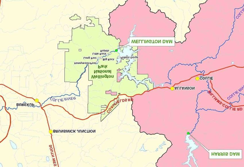
Irrigation District. This water also supports a modified downstream environment and
associated social values (e.g. canoeing, Aboriginal heritage). A reduction (e.g. piping
the irrigation water directly from the dam) or a change in release timing (e.g. changes
in how Wellington Reservoir is used) may diminish these values. Those who
commented do not want to see these values diminished.

Many of the stakeholder representatives noted that the withdrawal rate of the
groundwater from the Collie Coal Basin is exceeding the sustainable yield of the
resource. The bulk of the groundwater withdrawn is through mine dewatering, which
is required in order to create a safe mine work environment. This use is governed by
State Agreement Acts. Stakeholders recognised mine dewatering as a priority use but
still expressed concern about the withdrawal rate.

Some stakeholders identified negative effects they attributed to the rate of
groundwater withdrawal. These included reductions in stream flow in the Collie River
South Branch, less water in river pools and land subsidence. The most talked about of
these issues were the pools. Pools on the South Branch and East Branch of the Collie
River are currently supplemented by Verve Energy and Griffin Coal, respectively.
Many stakeholders view the pool supplementation issue as very much a Cardiff or
Buckingham issue of limited interest to those not directly affected. However, for those
local stakeholders who value the pools, the future of the supplementation program is a
significant issue. They would like the program to continue but with modifications to
address the water quality (e.g. iron) and delivery issues (due to the overflow method
the pools are ‘unnaturally’ high in summer).

The South Branch and East Branch pools were among a number of water features
identified as having non-consumptive social values. A large majority of those
interviewed identified the Wellington Dam/Reservoir and the Collie River
immediately below the Wellington Dam as having significant social value. The other
feature identified in the majority of interviews was Lake Kepwari. Other features
identified were the Harris Reservoir, several former mine voids (i.e. Stockton Lake
and Black Diamond A), and river pools on the Collie River (e.g. Minninup Pool).

                                                                                     ii
Table of Contents
1      Introduction..........................................................................................................1
    1.1     Background ....................................................................................................1
    1.2     Issue Scoping .................................................................................................3
    1.3     Report Format ................................................................................................5

2      The Water Resources...........................................................................................6
    2.1    Surface Water.................................................................................................6
    2.2    Ground Water.................................................................................................8
    2.3    Future Demand for Consumptive Use .........................................................10

3      Surface Water Use .............................................................................................12
    3.1    Wellington Reservoir ...................................................................................12
    3.2    Harris Reservoir ...........................................................................................18
    3.3    Mungalup Reservoir.....................................................................................19
    3.4    Minninup Pool .............................................................................................19
    3.5    Pool Supplementation ..................................................................................20
    3.6    Former Mine Voids......................................................................................22
    3.7    Private Use ...................................................................................................24
    3.8    Agriculture Upstream of Wellington Reservoir...........................................25
    3.9    Environmental Flows ...................................................................................25
    3.10 Salinity Management ...................................................................................26

4      Groundwater Use ...............................................................................................28
    4.1    Background ..................................................................................................28
    4.2    Mine Dewatering and Power Generation.....................................................28
    4.3    Small Private Users......................................................................................29
    4.4    Level of Use .................................................................................................29
    4.5    Priority Use and Impact Mitigation .............................................................30
    4.6    Water Quality...............................................................................................31

5      Social Water Requirements ..............................................................................32
    5.1    Definitions....................................................................................................32
    5.2    Social Value Attributes ................................................................................32
    5.3    Identified Water Features.............................................................................33
    5.4    Wellington National Park ............................................................................34
    5.5    Harris Reservoir ...........................................................................................37
    5.6    Collie River..................................................................................................37
    5.7    Former Mine Voids......................................................................................41
    5.8    Summary of Feature Characteristics............................................................42
    5.9    Social Water Requirements..........................................................................47

6      Community Engagement...................................................................................49
    6.1   Key considerations.......................................................................................49
    6.2   Levels of Engagement..................................................................................51
    6.3   Engagement Objectives ...............................................................................52
    6.4   Mechanisms for Engagement.......................................................................53
    6.5   Monitoring and Evaluation ..........................................................................58

                                                                                                                           iii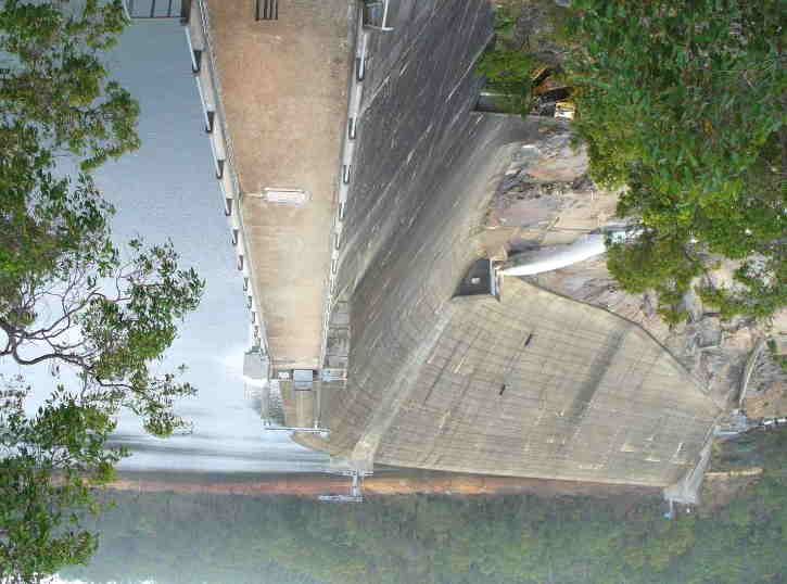
References...................................................................................................................59
Appendix A         Interview Guide..............................................................................62
Appendix B         Database Variables and Stakeholder Categories........................65
Appendix C         Study Participants..........................................................................67
Appendix D         Identified Information Needs........................................................69

                                                                                                                            iv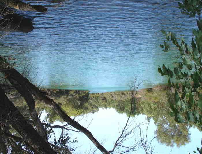
Acronyms
CALM     Department of Conservation and Land Management
CWAG     Collie Water Advisory Group
DAFWA    Department of Agriculture and Food Western Australia
DEC      Department of Environment and Conservation
DoCEP    Department of Consumer and Employment Protection
DoE      Department of Environment
DoH      Department of Health
DoIR     Department of Industry and Resources
DoW      Department of Water
GSTWSS   Great Southern Towns Water Supply Scheme
IWSS     Integrated Water Supply Scheme
SWDC     South West Development Commission
WC       Water Corporation
WRC      Water and Rivers Commission

                                                                v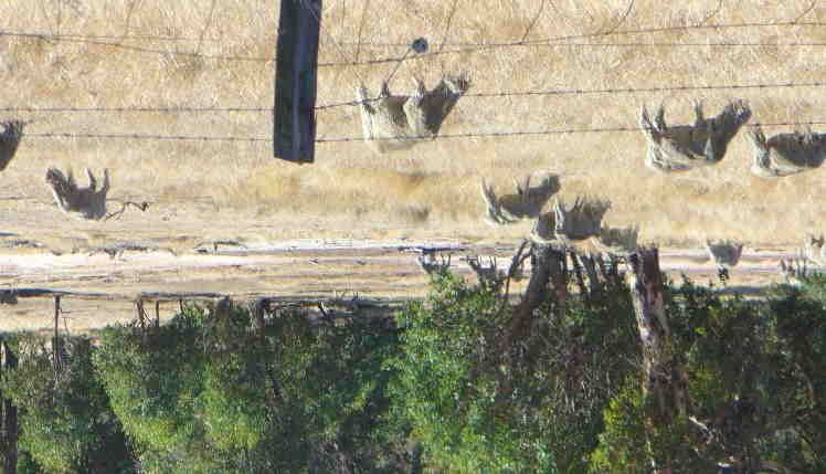
1       Introduction

1.1     Background
The Upper Collie Catchment includes the surface water resources of the Harris Reservoir,
the Wellington Reservoir, and the upper Collie River and its tributaries, including the
Harris and Bingham rivers. It also includes the groundwater resources of the Collie Coal
Basin (Map 1).

Collectively these ground and surface water resources support a variety of consumptive
and non-consumptive uses and values. These include coal mining and power generation,
public water supply, irrigated agriculture, recreation and tourism, and the maintenance of
cultural, aesthetic and ecological values.

The Department of Water (DoW or Department) is the State Government agency
responsible for water resource planning in Western Australia. Currently, the Department
does not a have a water management plan to guide its licensing and allocation decision-
making for the ground and surface water resources of the Upper Collie Catchment.

The development of a plan is timely as the pressures on these water resources are growing,
especially the demand for consumptive use. Most notable are proposals to develop
additional coal-fired power stations in the Collie area. If built these would require a
substantial increase in the volume of cooling water needed. In combination with further
coal mining activity, this could place additional pressure on groundwater resources that are
already experiencing withdrawal above the level of sustainability.

The demands placed on surface water resources are also increasing. Water from the
Wellington Reservoir supports irrigated agriculture in the Collie Irrigation District1 as well
as recreation activities. Other consumptive water users may have a longer-term interest in
this large surface water resource. These include both industry (e.g. the energy sector) and
the Water Corporation to supply the Integrated Water Supply Scheme.

The Department of Water has made a commitment to the National Water Commission2 to
develop a statutory3 water management plan for the water resources of the Upper Collie
Catchment by the end of 2010. The water planning will occur in two stages. The first stage
is to prepare an initial water management plan due for release in 2007. The second stage of
work will be the development of the statutory water management plan by the end of 2010.

1
  The Collie Irrigation District is located downstream of the Wellington Reservoir, west of the Burekup
Weir.
2
  The Commission is the Federal Government body responsible for helping drive national water reform.
3
  Statutory means that the plan will be legally binding.

                                                                                                          1
Map 1 Upper Collie Catchment

                               2
Water Management Planning Objectives
The initial water management plan will:
Provide rules and policies to support sustainability outcomes in management and
licensing decisions, including managing the impact of use
Provide clear requirements for industrial water users to mitigate and minimise the
impact of groundwater abstraction and identify how compliance will be ensured
Facilitate secure water supply for current and future needs (including use and non-
use demand)
Address elements of Water Law Reform particularly relevant to water management
in the Upper Collie Catchment
Guide sustainable water management during the period while further technical work
and legislative reform continues.
1.2 Issue Scoping
The Department retained Beckwith Environmental Planning to conduct an issue scoping
exercise. The objectives of the scoping exercise were to:
Identify stakeholder issues regarding current and future surface and ground water
allocation and resource management in the Upper Collie Catchment.
Identify water features stakeholders view as having significant social and/or cultural
values and the water conditions required to sustain these values.
Provide advice regarding the integration of public engagement in the development
and implementation of the Department’s initial water resource management plan.
Method
Issue scoping is a technique used to gain an understanding of the range of stakeholder
perspectives on a particular topic. In this case, the topic is the future management of
ground and surface water resources in the Upper Collie Catchment.
The outcomes of a scoping exercise can assist an agency to:
Identify areas of agreement and shared perspectives as well as those with the
potential to generate conflict.
Identify stakeholders with complementary perspectives or needs and thus the
potential for partnerships.
Focus its efforts on issues important to stakeholders.
Monitor progress on these issues over the course of the water planning process.
The issue scoping exercise generated data through in-depth interviews with representatives
of a range of stakeholder interests. The major strength of in-depth interviewing is the rich
data it generates. In contrast to a methodology such as a questionnaire, the conversational
style of interviews allows the individual to use their own words and delve more deeply
into the reasons behind their positions and perceptions. To the extent possible, interviews
were conducted individually and face-to-face rather than in groups.
3To encourage consistency in data collection, a semi-structured interview format was
applied. An interview guide was used to ensure that the following 12 issues were explored
during all interviews (Appendix A):
Key water resource issues
Potential barriers to successful water resource management
Priority water uses for resource allocation
Ecological water needs
Pool supplementation
Surface water use and impacts
Groundwater use and impacts
Potential future water uses
Water quality issues
Climate change
Community engagement needs during planning and plan implementation
Water features with notable social/cultural values
Stakeholders were asked additional questions reflecting their specific interests in water
resource management.
The interviewer took hand written notes during interviews and, with the individual’s
permission, interviews were tape recorded to ensure accuracy. The interviews ranged in
duration from 45 minutes to 2.5 hours. The typed interview notes and tape recordings
were reviewed multiple times and the data was organised into themes.
The scoping exercise was not designed to provide a statistically representative sample of
stakeholder or community opinions. Rather, the objective was to ascertain the range of
perspectives held by the stakeholders.
However, to give an indication of the level and type of responses obtained in the
interviews a simple frequency analysis was conducted. The data from each interview was
entered into a database. The database consisted of a series of variables (i.e. issue themes
and sub-themes) and response categories. To allow within group and between group
comparisons, each interview participant was assigned to one of 9 stakeholder categories.
The variables and stakeholder categories are provided as Appendix B.
Participants
With the assistance of the Department’s Bunbury Office, key stakeholder interests and
representatives were identified. For each stakeholder interest, one or more stakeholder
representatives were identified for an interview. This included representatives of local
governments, relevant state government agencies, local environmental groups, industry,
agriculture, the Nyungar community, tree plantations and recreation interests.
Prospective interviewees were contacted by telephone and email to request their
participation and arrange a convenient date and location for an interview. In total, 62
stakeholder representatives were interviewed in the period January-March 2007 (Appendix
C).
All those interviewed will receive a copy of the scoping report. The Department will make
the report available on its website: www.water.wa.gov.au.
41.3 Report Format
Chapters 2-4 examine key themes arising from the stakeholder interviews. Chapter 5
examines water features with notable social values and their social water requirements.
The final chapter discusses the integration of community engagement in the development
and implementation of the DoW’s initial water management plan for the Upper Collie
Catchment.
52 The Water Resources
2.1 Surface Water
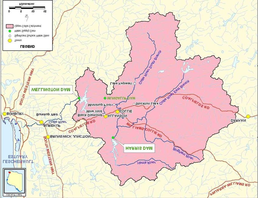
The main river in the Upper Collie Catchment is the Collie River. Its largest tributaries are
the East Branch, the Bingham River, the Harris River and the South Branch (Map 2).
Northeast of the Town of Collie, the East Branch and the Bingham River converge to form
the Collie River. From this point, the Collie River flows westward and is joined by the
Harris River downstream of the Harris Reservoir. Flowing southward, the Collie River
passes through the Collie townsite and converges with the South Branch. The Collie River
then flows westward where it enters the Wellington Reservoir. Below the Wellington
Reservoir, the Collie River continues westward through the Wellington National Park, past
the Burekup Weir, before discharging to the Leschenault Estuary.
The Wellington Dam and
Reservoir are located within
the boundary of the Wellington
National Park. The Wellington
Reservoir is the single largest
reservoir in the South West. It
was built in 1933 as a source
of water for irrigation. Over
the years, its original storage
capacity of 35 GL was
augmented several times by
increases to the height of the
dam wall. The last increase
occurred in 1960, bringing the
storage capacity to its current
186 GL. By the 1950s, the
reservoir was also supplying drinking water to the Great Southern Towns Water Supply
Scheme (GSTWSS). However, increasing salinity levels resulted in its eventual
replacement by the new Harris Reservoir as a source of water for the GSTWSS. A 2
megawatt hydro-power plant was constructed in the 1950s, directly downstream of the
Wellington Reservoir. Owned by Verve Energy, the facility is no longer in operation.
The Harris Reservoir was constructed in 1990 as the new source of public water supply for
the Town of Collie and the 31 towns connected to the GSTWSS. Located on the Harris
River (approximately 12 km north of Collie), it has a storage capacity of 72 GL. Water
from the Harris Reservoir (i.e. Lake Balingall) is treated before transport to the GSTWSS.
Chlorine is added for disinfection and the pH is stabilised by adding lime and carbon
dioxide. Fluoride is also added to the water (Department of Water 2007).
6Map 2 Collie Surface water
7As part of the Water Corporation’s Stirling-Harvey Redevelopment Scheme, opened in
2002, a 16 kilometre water pipeline was constructed to enable 5 GL of water to be moved
from the Harris Reservoir to Stirling Reservoir for use in the Integrated Water Supply
Scheme. However, this water transfer has not occurred in recent years due to lower water
levels in the Harris Reservoir4. “Once a new treatment plant is established at Harris Dam
to maintain water quality during periods of low water level … the Water Corporation plans
to once again undertake transfers to Stirling [Reservoir]” (DoW 2007, pg. 1).
Table 1 Comparison of water storage
Facility Surface area Storage Sustainable Allocation
capacity yield
Wellington Reservoir 1,609 ha 185.0 GL 85.1 GL 68.0 GL
Harris Reservoir 9,575 ha 72.0 GL 17.0 GL 15.0 GL
Mungalup Reservoir 162 ha 0.7 GL 0.5 GL
Serpentine Reservoir 1,067 ha 137.7 GL
Mundaring Reservoir 676 ha 63.6 GL
2.2 Ground Water
Since coal was discovered in the area in 1883, Collie has become the State’s main centre
for coal production and power generation. The Town of Collie and smaller nearby
communities, including Cardiff, were established near the early underground coal mines.
Since 1994, all coal mining in the area employs the open cut method. Griffin Coal and
Wesfarmers Premier Coal are the two coal production companies in Collie.
The main groundwater resources of the Upper Collie Catchment are concentrated in the
Collie Coal Basin (Map 3). The Basin is bilobate in shape and covers an area of 230 km2
near the Town of Collie. It contains significant groundwater and coal resources. The Collie
Coal Basin was proclaimed as part of the Collie Groundwater Area in June 1977.
The Collie Coal Basin is divided into two sub-basins (Map 3). The Cardiff Sub-basin
contains 67% of the Basin’s groundwater resources with the remaining 33% in the Premier
Sub-basin (CWAG 1996). A second, smaller groundwater basin, the Wilga Basin, is
located south of the Collie Coal Basin. The unproclaimed Basin contains groundwater and
coal resources. In addition to the Collie and Wilga Basins, there are a number of small
pockets of groundwater in the catchment. However, they are difficult to delineate and the
DoW considers them too small for management purposes.
The surface of the Collie Coal Basin is gently undulating with streams, creeks and swamps
in low-lying areas. Open-cut coal mining in the Collie Coal Basin has created numerous
mine voids where mining has ceased. Over time, as the groundwater levels return, the old
mine voids flood and become mine lakes. Deeper than natural lakes, several of the former
mine voids are now used as lakes for recreation purposes (i.e. Stockton Lake, Lake
Kepwari5 and Black Diamond A).
4
The transfer from Harris Reservoir to Stirling Reservoir has only happened in one year. The licence
condition indicates that the transfer will only happen once regional needs are met.
5
Lake Kepwari is scheduled to be opened for recreational use in late 2007.
8Map 3 Collie Coal Basin
9The mined coal is used primarily to generate electricity at three power stations near Collie.
Verve Energy’s6 two major coal-fired power stations in the Collie area provide electricity
to the South West Interconnected System 7. Opened in 1966, the Muja Power Station is 22
kilometres east of Collie. The Muja Power Station has four 200 megawatt (MW)
generating units8. Opened in 1999, Verve’s Collie Power Station is situated 10 km north of
Collie and is capable of producing more than 300 MW of electricity. Brine, or saline
wastewater produced during the cooling process, is transported via pipeline to an ocean
outfall9 for disposal.
The third power station, Bluewaters I, will be operated by Griffin Energy10. Construction
has commenced on the 208 MW coal-fired power station. The station is located 10 km
north east of the Collie townsite. Coal supplies for the station will be sourced from Griffin
Coal. Commissioning of the station is expected by late 2008 (South West Development
Commission http://www.swdc.wa.gov.au).
Bluewaters I is designed in a modular fashion to facilitate future growth. Griffin Energy is
seeking to develop a second power station – Bluewaters II (Griffin Energy 2006).
2.3 Future Demand for Consumptive Use
If demand increases it is most likely to come from the energy sector and public water
supply for the Integrated Water Supply Scheme. Although the water in Wellington
Reservoir is still too brackish for use as public water supply, the Water Corporation is
planning ahead and has applied to the Department of Water for a 17 GL allocation from
Wellington Reservoir. The application requests 12 GL for inclusion in the IWSS and 5 GL
of industrial water for use by Verve Energy (Water Corporation 2004a). The Department
of Water has yet to make a determination on the Water Corporation’s application (Water
Corporation 2004a).
Additional water demand would be generated if two proposals for industrial parks near
Collie are realised. The Shotts Industrial Park, a development proposed by the Shire of
Collie and the South West Development Commission, would be located 12 km east of
Collie, near the old Shotts townsite. The proposed park would serve heavy industrial
needs. The second proposal is The Griffin Group’s Coolangatta Industrial Park. Griffin
Coal’s Bluewaters I coal-fired power station would form the foundation of the industrial
park located 10 km north east of the Collie townsite.
Industries outside the Upper Collie Catchment are another potential source of water
demand. The Worsley Alumina refinery is located in the upper portion of the Brunswick
River catchment, just west of the Upper Collie Catchment. The refinery is licensed by the
DoW to use 2.1 GL per year from the Augustus River (a tributary of the Brunswick River).
In order for a planned expansion to proceed, Worsley Alumina needs to increase its
licensed allocation to 2.6 GL per year (Strategen 2005). The company has identified
6
Verve Energy was created in April 2006 when Western Power separated into four businesses as part of the
State Government energy market reforms.
7
The South West Interconnected System (SWIS) provides electricity to an area bounded by Geraldton to the
north, Kalgoorlie to the east and Albany to the south.
8
On 30 April 2007 Verve Energy closed four 60MW generating units at the Muja Power Station.
9
The outfall is off Buffalo Road, north of the Leschenault Estuary.
10
Griffin energy is a subsidiary of The Griffin Group.
10several potential future water supply options. These include: water from a service provider
(e.g. Water Corporation), nearby regional surface sources (e.g. Wellington Reservoir), coal
field dewatering (i.e. Collie) and greater use of the Augustus River (Strategen 2005).
The Kemerton Industrial Park is located 17 km north of Bunbury. Currently, the industrial
park uses local groundwater resources to provide their supply. Increased demand may
arise if new industry establishes in the park. Several stakeholders identified the water
resources of the Upper Collie Catchment and in particular Wellington Reservoir are
possible sources to meet this future demand. Several stakeholders identified Alcoa’s
alumina refinery at Wagerup Refinery as a possible source of future demand.
Several of those interviewed view the former hydro-power station at Wellington Reservoir
as a lost opportunity. There are two proposals to refurbish the former hydro-power plant.
One proposal is to reopen the hydro-power plant in conjunction with development of a
desalination plant. The desalination plant would reduce the salinity of water from
Wellington Reservoir making it viable for use by the Integrated Water Supply Scheme.
The desalination plant would rely on power from several sources, including the hydro-
power plant. The second proposal is to reopen the hydro-power plant as a “green power”
venture and part of a tourist attraction featuring the Wellington Dam.
113 Surface Water Use
3.1 Wellington Reservoir
Salinity
In stakeholder interviews, the dominant
water quality issue was salinity (80% of Salinity Levels (Mayer et al 2005)
interviews). High salinity levels in the Classification
Upper Collie Catchment, have limited the Fresh 5,000 mg/L TDS
River Catchment resulted in the Highly saline 10,000-35,000 mg/L TDS
replacement of deep-rooted trees and Brine >35,000 mg/L TDS
Hypersaline >50,000 mg/L TDS
vegetation by shallow-rooted annual crops
and pastures. This allowed the watertable Seawater contains 35,000 mg/L TDS
to rise, bringing salt stored in the soils to
the surface and eventually into streams.
In 1933, the water in the Wellington Reservoir was ‘fresh’ at about 280 mg/L total
dissolved solids (TDS) (Water and Rivers Commission 2001a). Despite the introduction of
clearing controls upstream of the Wellington Reservoir in the 1970s, salinity levels
continued to rise and eventually exceeded the drinking water guidelines11. In the early
1990s, Wellington Reservoir was replaced by the Harris Reservoir as the source of public
water supply for the Great Southern Towns Water Supply Scheme.
By 1990, clearing controls and an extensive reforestation plan had helped to arrest the
trend of increasing salinity in the Wellington Reservoir. However, by 2001, the water in
Wellington Reservoir was still only ‘marginal’ at around 945 mg/L TDS (DoW 2006). The
State Salinity Strategy (State Salinity Council 2000) identified the Upper Collie
Catchment as one of five water resource recovery catchments 12 and set a salinity target of
500 mg/L TDS by 2015 for the Wellington Reservoir.
The Collie Recovery Team was formed in 1995 to help restore fresh water to the
Wellington Reservoir. It consists of farming, community and agency representatives with
the Department of Water (formerly the Water and Rivers Commission) as the lead agency.
The 12 member team includes: landholders from the East Branch, James Well and South
Branch of the Collie; catchment representatives from the West Arthur and Collie Shire
Councils; Department of Water; Department of Agriculture and Food; Department of
Environment and Conservation; Water Corporation; and Verve Energy.
11
Water at or below 500 mg/L TDS achieves the drinking water quality guideline for salinity (National
Health and Medical Research Council and Natural Resource Management Ministerial Council 2004).
12
Water resource recovery catchments were selected based on two criteria: (1) existing or future water
sources for the South West and (2) without active management would deteriorate beyond recovery.
12Scouring
Since 1976, water from the base of Wellington Reservoir is scoured as part of the dam’s
maintenance. The scouring water is released to the Collie River following the first saline
inflows of the season and when a difference exists in salinity levels between the top and
bottom of the reservoir. This helps minimise the loss of fresh water over the top of the dam
and removes the most saline water from the base of the reservoir.
Those stakeholders who commented on the scouring process accept it as part of managing
the reservoir. Some were unsure as to when water is released from the reservoir for
scouring versus releases for irrigation. Scouring typically occurs between June and August
whereas the irrigation season is from October to April (Harvey Water
www.harveywater.com.au).
Irrigated Agriculture
Although the Wellington Reservoir has a storage capacity of 186 GL, its annual
sustainable yield is 85.1 GL. Currently the only consumptive user of water from
Wellington Reservoir is Harvey Water.
Harvey Water has a licensed allocation of 68 GL/year (Economic Regulation Authority
2006). Of this, the majority is for irrigated agriculture while the remainder goes to
industrial use (i.e. Doral Mining), historical releases and water losses from Harvey
Water’s open channel system. Harvey Water has been using approximately 50 GL
annually or 74% of its allocation
(Water Corporation 2004a).
Harvey Water uses the water from
the Wellington Reservoir to meet the
needs of irrigated agriculture in the
Collie Irrigation District. Water
released for irrigation is temporarily
stored downstream at Burekup Weir.
Here it is diverted into Harvey
Water’s channel system and
delivered to its agricultural
customers.
Harvey Water works closely with
the Water Corporation (the Dam
owner) to time the irrigation releases from the reservoir. It takes approximately 20 hours
for the water to travel from the Wellington Reservoir to the Collie Irrigation District.
Several stakeholders noted that timing the release of irrigation water can be tricky.
Burekup Weir can store only a one-day supply of water for irrigators. If more water is
released from the reservoir, it flows over the top of the Weir. These stakeholders would
like the system to be more efficient. Solutions offered were: (a) raising the Weir although
it would be costly or (b) piping the irrigation water directly from Wellington Reservoir to
circumvent the need for Burekup Weir.
13The water from Wellington Reservoir is not of optimal quality for irrigated agriculture.
Several stakeholders indicated the salinity content is restricting the types of crops that can
be grown. A reduction in salinity would likely stimulate a shift from irrigated pasture to
higher value, but less salt tolerant, horticultural crops.
If salinity of the irrigation water decreased a number of stakeholders indicated that water
demand from the Collie Irrigation District would likely decrease. The ability to grow
higher value crops would make the conversion of the existing channel system to a piped13
system more economically feasible. As has occurred in the Waroona and Harvey Irrigation
Districts, the conversion would significantly reduce the amount of water lost to leakage
and enable irrigators to use more water efficient technology (e.g. pivot systems).
As part of its water licence, Harvey Water is required to release a small amount of water
annually to the Henty and Ferguson Rivers and the Brunswick River to satisfy historical
uses such as the Brunswick Junction pool. It was suggested these releases be reviewed to
determine if they are (a) meeting their intended purpose or (b) still necessary.
Reservoir recreation
The recreation of Wellington Reservoir and its surrounds was discussed by a number of
stakeholders (80%). While the dam is managed by the Water Corporation, the area around
the reservoir is managed by the Department of Environment and Conservation (DEC)14 as
part of the Wellington National Park. In late 2006, the DEC released its Draft
Management Plan for Wellington National Park and Westralia Conservation Park
(CALM 2005).
Recreational fishing, canoeing,
marroning and swimming were
identified as popular activities.
Although the reservoir is not stocked,
recreational fish species include
redfin, perch and trout. Motor boats
and thus water skiing are not allowed
on the reservoir. Nearby camping,
picnicking and bush walking
opportunities complement the water-
based activities.
Many stakeholders view public water supply for the Integrated Water Supply Scheme as a
likely use of Wellington Reservoir at some point in the future. They were also aware that
water quality risk managers consider water-based recreation an incompatible use on public
water supply. Many discussed the potential for conflict should a decision be made to
remove recreation from Wellington Reservoir to protect public water supply quality. It
was noted that an attempt five years ago by the Water and Rivers Commission to consult
with the Collie community regarding the development of a source protection plan for the
Wellington Reservoir was not well received.
13
The starting point for such a pipeline has not been explored.
14
The Department of Environment and the Department of Conservation and Land Management
amalgamated to for the Department of Environment and Conservation on 1 July 2006.
14Many did not believe the removal of recreation was necessary in order to protect public
health. Many stakeholders requested that a range of options be evaluated using a
transparent process before a decision is made about the future of recreation on Wellington
Reservoir. This would include options to increase the level of water treatment rather than
reducing recreation. Some stakeholders gave examples of overseas or eastern states
experiences to support their contention that recreation and public water supply can co-
exist. To emphasise their position, some local stakeholders stated they would be happy to
pay more for their drinking water if it meant recreation could remain on the reservoir.
The ongoing case of Logue Brook, where the Water Corporation plans to shift the
consumptive use of water from ‘irrigation and recreation’ to ‘irrigation and public water
supply’, was given as an example where recreation may lose out to public water supply
protection. A decision has not yet been made on Logue Brook. This case prompted calls
for an evaluation of options to include the impact or cost of finding an alternative
recreation resource to replace recreation activities removed from the reservoir. Most
stakeholders rejected any suggestion that the loss of recreation access at Wellington
Reservoir could be offset by the recently developed Lake Kepwari. Stakeholders view
Lake Kepwari as a positive addition to the community’s recreation assets and a draw card
for those interested in water skiing in particular. However, they do not perceive it as a
replacement venue for recreation. Due to the differences in their characteristics (e.g. size,
natural amenity, type of activities), they view comparing Lake Kepwari with Wellington
Reservoir as a case of comparing apples with oranges.
Many of those interviewed (48%) commented that while a public water supply source
protection plan would, on paper, reduce the risk to water quality and public health a
smaller risk reduction would be realised in practice. The risk would not be reduced to the
intended level if measures in the plan cannot be fully implemented. Several stakeholders
noted that recreation activities such as marroning are prohibited on Harris Reservoir. Yet,
despite clear signage and agency patrols, it is well known that a significant amount of
marroning still occurs. At present there are three State Government agencies that patrol the
Wellington Reservoir - the Department of Fisheries (fishing and marroning regulations);
the Department of Environment and Conservation (fires, rubbish and anti-social
behaviour); and Water Corporation’s catchment officers. The agencies noted that, at
current resource levels, not all undesirable behaviour can be eliminated.
Some stakeholders noted that other uses in the catchment could also pose a threat to public
water supply quality in Wellington Reservoir. The community of Allanson, upstream of
the reservoir, is serviced by septic tanks and was the most frequently cited example. A
couple of stakeholders mentioned forest management and its potential threat to water
quality (e.g. erosion, dieback) and potential to reduce run-off (e.g. canopy density).
Stakeholders questioned how the source protection plan would address these potential
sources of contamination.
Recreation downstream of the reservoir
Within the Wellington National Park, there are five Department of Environment and
Conservation managed recreation venues downstream of the Wellington Reservoir along
the Collie River (Map 4). This includes The Rapids, Big Rock, Little Rock, Long Pool and
Honeymoon Pool sites. The sites offer a variety of recreation opportunities, including
marroning, fishing, picnicking, camping and canoeing.
15Map 4 Wellington National Park Recreation Sites
16A number of stakeholders commented on the popularity of these locations, especially the
two larger sites (i.e. Long Pool and Honeymoon Pool). The DEC and some stakeholders
noted that these areas often reach capacity during school and public holidays. The DEC
has recently upgraded and hardened its visitor facilities downstream of the reservoir.
Aboriginal Cultural Values
The entire Collie River is a registered mythological heritage site (ID 16713) under the
Aboriginal Heritage Act. The river is connected to Ngarngungudditj Walgu, a mythical
water snake deemed responsible for creating the Collie River, the Collie River valley hills
and the Leschenault Inlet (Department of Conservation and Land Management 2005).
The Department of Environment and Conservation consulted with Nyungar elders in the
development of the Draft Management Plan and the upgrading of recreation sites
downstream of the Wellington Reservoir, including camping areas along Lennard Track.
The importance of protecting Aboriginal cultural values limits the potential to expand
recreation venues such as Honeymoon Pool. Following consultation with the Nyungar
community, DEC prohibited informal camping along Lennard Track to minimise
disturbance to the natural environment and protect cultural values.
Future allocation options
During the scoping interviews, the following future allocation scenarios were put forward
by stakeholders for the Wellington Reservoir:
Scenario A: A large allocation is made to public water supply for the Integrated Water
Supply Scheme (IWSS). If at the time of the allocation, the water had yet to attain the
drinking water guideline for salinity, it would be transferred by a new pipeline to either
Serpentine Reservoir or South Dandalup Reservoir for storage and buffering before use
in the Integrated Water Supply Scheme. The remaining water under the diversion limit
would be allocated to irrigated agriculture (i.e. Harvey Water). This volume of water
may or may not meet its water needs.
Scenario B: A large allocation is made to public water supply from the Reservoir in
combination with groundwater from the Collie Coal Basin (i.e. mine dewatering).
Additional water for public water supply may be obtained from irrigated agriculture
(i.e. Harvey Water) through: a water trade of the savings made by piping the Collie
Irrigation District, purchasing all or part of unused water allocations, or purchasing
entitlements from those irrigators willing to sell. Remaining water from Wellington
Reservoir would be supplied to irrigated agriculture or industry.
Scenario C: Meeting the water needs of irrigated agriculture (i.e. Harvey Water) is
given highest allocation priority. The remaining water under the diversion limit would
be allocated to the Water Corporation for inclusion in the IWSS. As a Scenario, the
IWSS bound water would be sent to Serpentine or South Dandalup reservoirs if the
drinking water guideline had not yet been achieved. The difference between Scenarios
A and C is the allocation priority assigned to meeting the water needs of irrigated
agriculture (i.e. Harvey Water).
Scenario D: As in Scenario B, the water needs of irrigated agriculture (i.e. Harvey
Water) are given highest allocation priority. However, the remaining divertible water
would be allocated to local and regional industry (e.g. Verve Energy, Griffin Energy,
17Kemerton Industrial Park). Pipelines would need to be constructed to transfer the water
to the industrial sites.
Scenario E: As in Scenario B, the water needs of irrigated agriculture (i.e. Harvey
Water) are given highest allocation priority. However, the remaining divertible water
would be allocated to a combination of public water supply (i.e. IWSS) and local and
regional industry.
Scenario F: A large allocation is made to industry (e.g. Kemerton, Verve Energy,
Griffin Energy, Alcoa and Worsley Alumina). This would require the construction of
pipelines to transfer the water to industrial sites. Remaining water would be allocated to
irrigated agriculture.
3.2 Harris Reservoir
The Harris Reservoir is located on the Harris River approximately 10 km north of the
Collie townsite. The reservoir has a capacity of 72 GL and an annual sustainable yield of
17 GL15 (DoW 2007).
The Water Corporation has the only licensed allocation from the Harris Reservoir. It is
licensed to use 15 GL annually16 (DoW 2007). Of this, 10 GL is for the Great Southern
Towns Water Supply Scheme and the Muja Power Station and 5 GL17 for inclusion in the
Integrated Water Supply Scheme and Worsley Alumina via pipeline transfer to the Stirling
Reservoir. The Water Corporation has applied to renew its licence and increase its
allocation from 15 GL to 17 GL (DoW 2007). The DoW has yet to make a determination
on their request.
The Great Southern Towns Water Supply Scheme supplies water to farmland and rural
communities in the South West and Great Southern Region, including Collie, Narrogin,
Lake Grace and Hyden. Many stakeholders accept public water supply as the priority use
for water from Harris Reservoir.
The transfer of water to the Integrated Water Supply Scheme via Stirling Reservoir has not
occurred in recent years due to low water levels, organic matter and tannins colour the
water (DoW 2007). “Once a new treatment plant is established at Harris Dam to maintain
water quality during periods of low water level … the Water Corporation plans to once
again undertake transfers to Stirling [Reservoir]” (DoW 2007, pg. 1).
A Draft Drinking Water Source Protection Plan has recently been prepared for the Harris
Dam catchment (DoW 2007). “Limited approved and managed recreation occurs in the
catchment, namely the Bibbulmun Track18 and an overnight accommodation hut” (DoW
2007, viii). Recreation is limited to reduce the risk of contamination to the Harris
Reservoir. As numerous stakeholder noted illegal marroning still occurs. There are
recreation facilities just downstream of the reservoir outside of the public water supply
catchment; this would remain the case, under the source protection plan.
15
The sustainable yield is currently being reviewed by the DoW.
16
The licence indicates the water needs of the region must be provided for before transferring to the IWSS.
17
The transfer from Harris Reservoir to Stirling Reservoir has only happened in one year.
18
The Bibbulmun Track is a popular walking track that extends from Perth to Albany.
18The Water Corporation is required to annually release water from the Harris Reservoir to
help reduce the salinity in the Wellington Reservoir. The release was a ministerial
condition placed on the Water Corporation at the time of the dam’s construction. Releases
of fresh water from the Harris Reservoir are intended to dilute the more saline water in the
Collie River.
Several stakeholders expressed concern that the required release from the Harris Reservoir
has not occurred the past few years. They noted that in summer, the portion of the Collie
River that passes through the townsite often becomes stagnant. The stakeholders want the
release renewed to improve water quality in the Collie River. This could also increase the
River’s social value and benefit recreational events such as the Collie Descent canoe
race19.
3.3 Mungalup Reservoir
Mungalup Dam is located 6 km south west of the Collie townsite on Mungalup Brook, a
small tributary to the Collie River. Built in 1935, it is a Water Corporation operated dam.
The Water Corporation has a licence to take 0.5 GL per year from the reservoir to supply
drinking water to residents in Mungalup and the southern part of the Town of Collie
(Water Corporation 2004b). The water is fluoridated and disinfected prior to distribution
(Water Corporation 2004b).
In 2004 a drinking water source assessment was conducted to identify potential sources of
contamination to the public water supply source (Water Corporation 2004b). The next step
will be the preparation of a drinking water source protection plan for the public water
supply source catchment. There is no public use (e.g. recreation) of the reservoir other
than the Bibbulmun Track along its eastern boundary.
One stakeholder commented that the public water supply system’s water pressure is poor
and attributed this to aging infrastructure. They questioned whether the reservoir would
continue to be used for public water supply in the longer term.
3.4 Minninup Pool
Minninup Pool is located on the Collie River, south of the Collie townsite. It was
identified by stakeholders as a popular area for swimming, picnicking and canoeing. The
site is often busy during school and public holidays and is used primarily by local
residents. The site has a grassed bank area and a small sandy beach, as well as picnic
tables and a carpark. The hardened portion near the pool is managed by the Shire of Collie
while the remainder is managed by the DEC. Because the water is calm, the pool is
popular for “family-style canoeing”. More ‘serious’ canoeists prefer other areas, such as
the section of the Collie River upstream of the pool.
The pool is a registered mythological Aboriginal Heritage site (Site ID 15330). It is where
Ngarngungudditj Walgu rested after creating the Collie River, the Collie River valley hills
and the Leschenault Inlet (CALM 2005).
19
The canoe race has been held since 2003 and runs from the Harris River Winery to Black Diamond A.
19Between Harris Dam and Minninup Pool
Recreational pursuits upstream of Minninup Pool identified by stakeholders include
swimming, fishing, marroning and canoeing. Local stakeholders noted that swimming in
the river used to be a more popular activity than it is today. The exception is Minninup
Pool where the numbers have remained
steady.
The reduction in river swimmers was
attributed to the presence of nardoo
(Section 5.6) and the opening of the Collie
swimming pool20. One stakeholder
indicated that while some marroning
occurs in the river, Wellington Reservoir
is a much more popular marroning site for
locals.
3.5 Pool Supplementation
Pool supplementation was a topic of discussion in 40% of the interviews. Those who did
not discuss the pool supplementation either did not feel knowledgeable enough about the
issue or they did not have an interest in the issue.
Many stakeholders view the pool supplementation issue as very much a Cardiff or
Buckingham issue of limited interest to those not directly affected. However, for those
local stakeholders who value the pools, the future of the supplementation program is a
significant issue.
Both the Collie River South Branch and East Branch are ephemeral. During summer, large
sections dry out reducing the rivers to a series of pools. Historically, the pools were “…
maintained by groundwater in reaches on the Basin in all but the most adverse summers”
(Collie Water Advisory Group 1996, p 3).
Over the years, extensive coal mining in the Collie Coal Basin resulted in lower
groundwater and less discharge to the pools. The potential negative effects on the pools
were initially obscured by the coal companies disposing their mine water to the rivers
along with saline water from the Muja Power Station. However, in the 1990s, mine water
was no longer viewed as wastewater but as a ‘resource’ for use in the power stations as
cooling water. At this time, the Muja Power Station adopted a zero discharge policy
(CWAG 1996). These two factors resulted in the release of much less water to the river
system.
By 1994, residents in the Cardiff/Collie Burn and Buckingham areas were raising concerns
about the decline in water levels in their domestic wells. Declines in pool water levels
were also evident. In 1995, the State Government created the Collie Water Advisory
Group (CWAG) “…to review the water resources management issues in the Collie Basin
and recommend to Cabinet a strategic water-management plan….” (WRC 2002, p 46).
20
The Collie Swimming Pool is a 50m heated pool.
20CWAG determined that the Buckingham Bridge Pool on the East Branch of the Collie
River had been “affected by [groundwater] pumping” and the South Branch of the Collie
River was “probably affected by groundwater abstraction” (CWAG 1996, 12). It
recommended that groundwater abstraction be minimised and eight designated pools be
maintained over a two-year period to preserve their “environmental and recreational
values”. CWAG (1996) anticipated that groundwater levels would recover over the two-
year period negating the need for long-term pool supplementation.
Supplementation began in the summer of 1995/96 but by 1999 it was evident that
groundwater recovery was taking longer than predicted. The WRC advised CWAG “…
that the watertable would have been above the bed level of all pools all year round, under
current climatic and land clearing conditions and without the influences of past mining and
groundwater abstraction” (CWAG 1999, p 3). CWAG concluded that “groundwater level
depression near river pools on the South Branch of the Collie River will continue to cause
some pools to remain dry for prolonged periods during summer until groundwater levels in
the vicinity recover” (CWAG 1999, p 2). They predicted similar impacts would occur on
the East Branch at the Buckingham and Duderling pools.
The Collie Water Advisory Group (1999) recommended that supplementation continue
during the summers of 1998/99 and 1999/00 and added Duderling Pool to the list of
nominated pools (Table 2). It was noted that, in the longer-term, the future of
supplementation should depend on consideration of a number of factors: social values,
environmental values, rate of groundwater recovery and the cost of supplementation
(CWAG 1999).
Table 2 Pools designated for supplementation
South Branch Pools East Branch Pools
Long Pool Buckingham Bridge Pool
Walker Pool Duderling Pool21
Cox Pool
Cardiff Pool (Town Pool)
Graham Pool
Piavanini Pool
Chinaman Pool
The supplementation of the pools has continued under an arrangement between the DoW,
Verve Energy and Griffin Coal. Currently, Verve Energy supplements the South Branch
pools, while Griffin Coal supplements the two East Branch pools. For the companies, their
participation in the supplementation program is as much about being good corporate
citizens and members of the local community as it is about redressing impacts.
The pools are supplemented in summer using an overflow (cascading) technique. The
supplemental water is released to the pool furthest upstream (i.e. Long Pool on the South
Branch), with the other pools filling as the water cascades downstream. Stakeholders
familiar with the pools noted that Piavanini Pool and Chinaman Pool do not receive much,
if any, supplemental water. However, this is not a concern to residents as Piavanini Pool
21
Duderling Pool was added to the list of supplemented pools by CWAG in 1999.
21You can also read