Snow & Prolonged Cold - February 5-14, 2021 - National Weather Service
←
→
Page content transcription
If your browser does not render page correctly, please read the page content below
Snow & Prolonged Cold
                                            February 5-14, 2021
                                         National Weather Service – Billings, MT

After a long period of warm temperatures and below normal snowfall from November through January, the weather
pattern shifted to much colder and snowier a few days into February. Significant snowfall occurred from the 5th through
the 7th over the west half of our forecast area, mainly from Roundup-Billings-Sheridan westward. As the snow fell,
temperatures turned colder as arctic air plunged from northern Canada. A prolonged period of severe cold lasted
through the middle of the month. Although the magnitude of the arctic air was comparable to many other winters, the
long duration of cold was significant.

METEOROLOGY: In early February, strong high pressure aloft built over the northern Pacific Ocean, and a northwesterly
jet stream developed over western Canada. In addition, there was a tap of tropical moisture extending from near Hawaii
to the Gulf of Alaska. The resulting moist northwest flow combined with deepening cold air from Canada produced an
extended period of “overrunning snowfall” in our region. Below is the 300mb jet stream analysis from February 5th.

Snow was fairly continuous through the 7th, as temperatures turned steadily colder. The weather pattern remained
favorable for allowing an air mass originating in the arctic to surge southward and impact a very large portion of central
North America, including our region, for several days. Below is a map of mean sea level pressure (shown in light blue) on
the morning of the 11th. Notice the strong (and cold) high pressure over western Canada extending into the northern
high plains, and much of the central United States.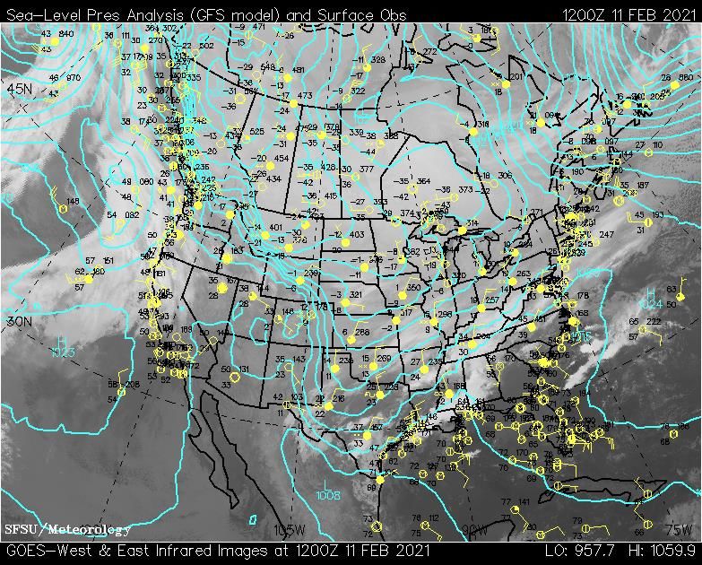
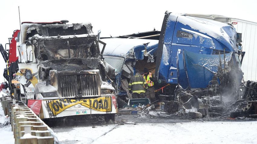
SNOWFALL: Most locations across the west half of our forecast area received between 10 and 15 inches of snow. There
were some higher reports, including 18 inches at Red Lodge and a few miles west of Reed Point. Eastern parts saw some
snow but much less accumulation. The following map shows total snowfall from February 5th through the 7th.

The snow and freezing temperatures caused highways to become snow-covered and very slick, and many accidents
occurred. Some highways were closed briefly due to multi-car pileups. Some of the more notable highway closures
included:
Feb 5 Highway 191 from Harlowton to junction with 87
Feb 6 I-90 MT/WY border
Feb 6 I-90 eastbound at Park City
Feb 7 I-90 westbound between Park City and Columbus
Feb 8 I-90 eastbound between Livingston and Big Timber
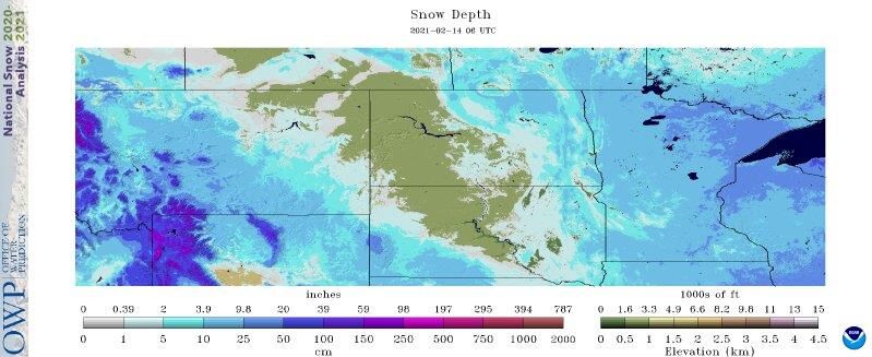
By the middle of February, significant snow cover existed over much of south central Montana and north central
Wyoming, but there was very little snow cover over northeast Montana and western North Dakota (these areas were
missed by several weather systems). Below is a northern plains snow depth analysis from the morning of the 14th.
FRIGID TEMPERATURES: A string of very cold temperatures impacted the region from the 6th through the 14th. Most
locations saw high temperatures stay below zero for about a week. The string of seven straight days with highs below
zero at Billings tied for 3rd longest since records began in 1934, and was the longest since 1985. Baker Municipal Airport,
a station with a period of record beginning in 1998, reported its overall record cold temp with -34°! The following is a
summary of the coldest reported temperatures at several airport and cooperative observer stations.
SITE COLDEST TEMPERATURE
Ingomar 9E -44°
Roundup 15SW -43°
Brandenberg -40°
Mizpah -38°
Hysham -37°
Springdale -37°
Baker -34°
Forsyth -34°
Miles City -34°
Broadus -32°
Hardin -32°
Columbus -30°
Bridger -29°
Livingston -28°
Billings NWS -27°
Sheridan -27°
Billings Airport -22°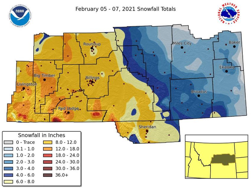
The most impressive facet of the cold snap was its long duration. Here are some statistics to put the week-long cold spell
into historical context.
Billings: 7 straight days with high temps below zero (3rd longest on record)
Livingston: 7 straight days with high temps below zero (longest on record)
Miles City: 6 straight days with high temps below zero (4th longest on record)
Miles City: 8 straight days with low temps of -15° or colder (4th longest on record)
Sheridan: 4 straight days with high temps below zero (6th longest on record)
Sheridan: 8 straight days with low temps of -11° or colder (5th longest on record)
TEMPERATURE AND SNOWFALL RECORDS: Several precipitation, snowfall and temperature records were broken during
this cold snap. Here is a summary from our four main climate stations.
SITE DATE NEW RECORD
Feb 5 5.2” snow
Feb 5 0.31” precip
Billings Feb 6 6.7” snow
Feb 6 0.37” precip
Feb 11 Low of -15°
Feb 13 Low of -28°
Livingston
Feb 14 Low of -24°
Feb 12 Low of -31°
Miles City Feb 13 Low of -28°
Feb 14 Low of -34°
Sheridan Feb 5 0.28” precip
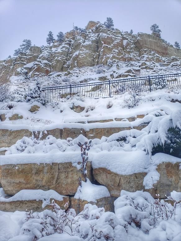
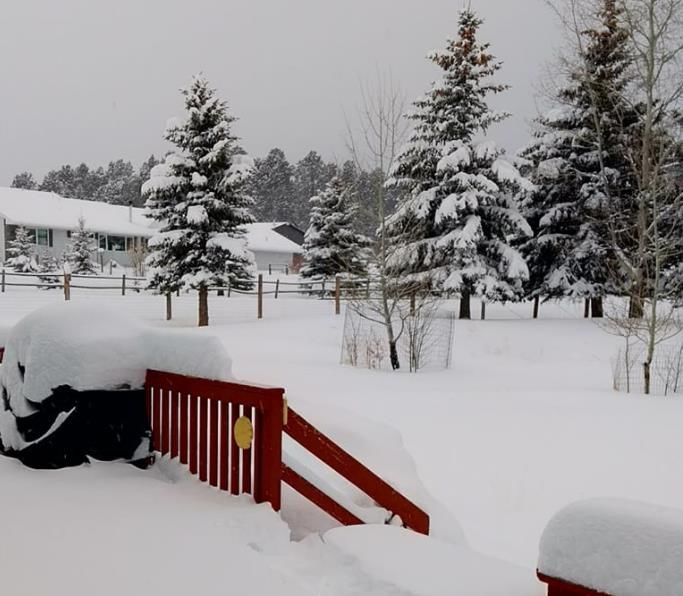
PHOTOS: Here is a sampling of the numerous photos we received. Thanks to everyone for sharing.
I-90 near Park City (Gazette)
Billings (Edwards)
Billings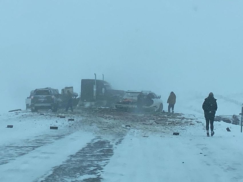
Story, WY (Small)

I-90 between Livingston & Big Timber (Gazette)

You can also read