Spatiotemporal Data Mining: A Survey on Challenges and Open Problems
←
→
Page content transcription
If your browser does not render page correctly, please read the page content below
Noname manuscript No.
                                         (will be inserted by the editor)
arXiv:2103.17128v1 [cs.LG] 31 Mar 2021

                                         Spatiotemporal Data Mining: A Survey on
                                         Challenges and Open Problems

                                         Ali Hamdi 1 . Khaled Shaban 2 .
                                         Abdelkarim Erradi 2 . Amr Mohamed                  2

                                         Shakila Khan Rumi 1 . Flora Salim 1

                                         Received: 24 Jun 2019 / Accepted: 29 Mar 2021

                                         Abstract Spatiotemporal data mining (STDM) discovers useful patterns from
                                         the dynamic interplay between space and time. Several available surveys cap-
                                         ture STDM advances and report a wealth of important progress in this field.
                                         However, STDM challenges and problems are not thoroughly discussed and
                                         presented in articles of their own. We attempt to fill this gap by providing a
                                         comprehensive literature survey on state-of-the-art advances in STDM. We de-
                                         scribe the challenging issues and their causes and open gaps of multiple STDM
                                         directions and aspects. Specifically, we investigate the challenging issues in re-
                                         gards to spatiotemporal relationships, interdisciplinarity, discretisation, and
                                         data characteristics. Moreover, we discuss the limitations in the literature and
                                         open research problems related to spatiotemporal data representations, mod-
                                         elling and visualisation, and comprehensiveness of approaches. We explain
                                         issues related to STDM tasks of classification, clustering, hotspot detection,
                                         association and pattern mining, outlier detection, visualisation, visual analyt-
                                         ics, and computer vision tasks. We also highlight STDM issues related to mul-
                                         tiple applications including crime and public safety, traffic and transportation,
                                         earth and environment monitoring, epidemiology, social media, and Internet
                                         of Things.

                                         Keywords Spatial, Spatiotemporal, Data Mining, Challenges Issues,
                                         Research Problems

                                         1   School of Computing Technologies, RMIT University, Australia
                                         2   Department of Computer Science and Engineering, Qatar University, Qatar

                                         BAli Hamdi
                                         E-mail: ali.ali@rmit.edu.au
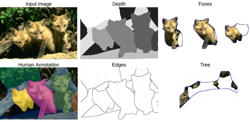
2             Spatiotemporal Data Mining: A Survey on Challenges and Open Problems

1 Introduction

There has been an increase in the research of Spatiotemporal Data Mining
(STDM) due to growing availability of geo-referenced and temporal data and
also due to the complexity and poor performance when applying classical data
mining methods [245, 275]. Large amounts of spatiotemporal data are being
generated and captured through systems that record sequential observations of
remote sensing, mobility, wearable devices, and social media. Spatiotemporal
data represent different phenomena ranging from micro-scale of DNA and cell
evolution, to global ones, e.g., climate change [302]. The wide-availability of
user-generated data via the social media platforms offers great opportunities
to understand people needs, thoughts, and sentiments toward specific topics,
products, or services [89]. Medical sensory devices observe different activities at
various locations of the human body over specific time ranges. STDM proposes
new methods to handle such data through advanced predictive and descriptive
tasks such as classification and clustering to work best with space and time
referenced data. STDM methods are concerned with relationships and de-
pendencies among different measurements. These relationships are complex,
implicit, and dynamically changing. To a large extent, classical data mining
assumes that data are independent and identically distributed (i.i.d.). On the
contrast, spatiotemporal data do not follow this assumption and STDM meth-
ods aim to capture the autocorrelation among different events or data points
that are interdisciplinary in nature, i.e, data from multiple domains that may
require the utilisation of various mining tasks.

Spatiotemporal data comprise spatial and temporal representations. They in-
clude three distinct types of attributes, namely, non-spatiotemporal, spatial
and temporal attributes [263]. The non-spatiotemporal attributes represent
non-contextual features of objects. Spatial attributes define the locations, ex-
tents, and shapes of the objects. Temporal attributes are timestamps and du-
rations of processes denoting spatial object (vector) or field (raster layers). For
example, air pollution spatiotemporal data have non-spatiotemporal attributes
such as air pollution levels or station names, spatial coordinates of the location
where the measurements are taken and temporal timestamps associated with
the collected measurements. Spatiotemporal data types can also be categorised
based on their collection nature to discrete or continuous observations. Events
and data trajectories are examples of spatiotemporal discrete data types, while
continuous data types include point reference and raster data. Spatiotemporal
event data constitute discrete events that happen at geo-locations and times
such as traffic accidents and crime incidents. Figure 1 (a) denotes spatiotem-
poral events of three different types. Each type is presented in different colour
and shape, e.g., red circles are for events of one type and each event is anno-
tated with the its location and time (location l1 in time t1 ). Trajectory data
contain sequences of spatiotemporal instances that trace motions of objects
in geographical spaces overtimes. Trajectories are usually represented by a se-
ries of chronologically ordered points which consist of spatial coordinates and
Spatiotemporal Data Mining: A Survey on Challenges and Open Problems                       3

Fig. 1 Spatiotemporal data types. (a) spatiotemporal events of different types at different
locations and timestamps. (b) spatiotemporal trajectories between locations (l1 and ln ) at
time (t1 and t2 ). (c and d) spatiotemporal point reference data at different locations at
timestamps (t1 and t2 ). (e and f) spatiotemporal raster data of regular grid at time (t1 and
t2 ).

timestamps [337]. For instance, a vehicle trajectory between two locations is a
set of consecutive points of space and time. Figure 1 (b) illustrates trajectories
of three coloured objects between locations (l1 and ln ) at times (t1 and t2 ).
Point reference data measure continuous spatiotemporal fields at moving spa-
tiotemporal reference sites. For example, spatiotemporal point references can
be utilised to measure surface temperature using moving balloons. Figure 1 (c
and d) show spatiotemporal point reference data at different locations (black
squares) at timestamps (t1 and t2 ). Raster data represent measurements of
spatiotemporal fields at fixed cells in grids such as activities in fMRI brain
scans. Figure 1 (e and f) show spatiotemporal raster data of regular grid at
time (t1 and t2 ). These different types of spatiotemporal data are associated
with different research challenges [10]. Classical data mining approaches are
not designed to handle such data.
    This paper consolidates the current state of the challenges associated with
the STDM tasks and applications. There have been several survey articles
that reviewed work related to STDM, each of which discussed the literature
from different perspectives such as spatial databases [133], spatial patterns
[246], spatiotemporal cluster analysis [131], urban concepts and applications
[338], big data analytics [301], big climate data analytics [100], and outliers
detection [3, 180]. [10] surveyed STDM methods and techniques according to
main spatiotemporal problems of clustering, predictive learning, change de-
tection, frequent pattern mining, anomaly detection, and relationship mining.
[198] reviewed the big geo-data mining objectives and issues in terms of hu-
man behaviour and distributions of geographical patterns. The survey by [245]
divided prior surveys in the literature into two types; articles with statistical
4             Spatiotemporal Data Mining: A Survey on Challenges and Open Problems

foundations [61, 133, 181], and others without that [3, 131, 246]. [278] surveyed
the utilised deep learning methods in STDM based on the data types, tasks and
deep learning models. The authors also presented the utilisation of deep learn-
ing methods in various applications. [338] surveyed the concepts and applica-
tions of urban computing and discussed their computing challenges. The work
in [249] presented a review of machine learning methods for STDM sequence
forecasting related problem. They focused on moving point cloud, regular grid,
and irregular grids. Due to the fast pace of advances in STDM, there is a con-
tinuous need for up-to-date surveys. Moreover, to the best of our knowledge,
STDM challenges and problems are not thoroughly discussed and presented in
articles of their own. Specifically, none of these existing researches paid their
focus on the general challenging issues in terms of relationships, data, natures
and limitations of STDM research or the challenges related STDM tasks and
applications. Our survey attempts to fill this gap providing a comprehensive
literature survey on state-of-the-art advances in STDM. Unlike existing sur-
vey papers, we review previous works and describe STDM challenges and their
causes as well as issues related to selected applications and tasks.
    Figure 2 shows a taxonomy of the proposed structure for reviewing the
STDM challenges. The taxonomy highlights the survey main sections and their
sub-sections. The survey is designed to cover the STDM related challenges
from three different perspectives. We start the survey by defining the general
challenging issues in terms of relationships, data, natures and limitations of
research. Then, we discuss the STDM tasks and applications focusing on their
related challenges. Finally, we conclude the survey with a mapping table and
a discussion to connect the general challenges with the tasks and applications
sections.
    The rest of the paper is organised as follows. The research methodology on
how we conducted this survey is presented in Section 2. Section 3 discusses gen-
eral STDM challenges and their causes. Section 4 covers STDM tasks and their
related challenges. Section 5 introduces STDM applications and related chal-
lenges in them. Section 6 summarises the survey and the integration between
the general challenges and STDM related tasks and applications . Section 7
highlights key conclusions and directions for future work.

2 Survey Methodology

We designed our survey to focus on STDM challenges and research problems,
as shown in Figure 2. We built a comprehensive set of STDM challenges, as
shown in Figure 6. This list of challenges is accompanied with their root causes.
We started extracting these challenges and causes from existing STDM surveys
in addition to our knowledge in the area. We then extended the challenges set
in terms of STDM tasks and applications. For example, an STDM previous
survey may list several challenges that are relevant to its scope, e.g., STDM
visualisation. We add these challenges to our survey by extending their defini-
tions and searching for their related work. The most frequent search keywords
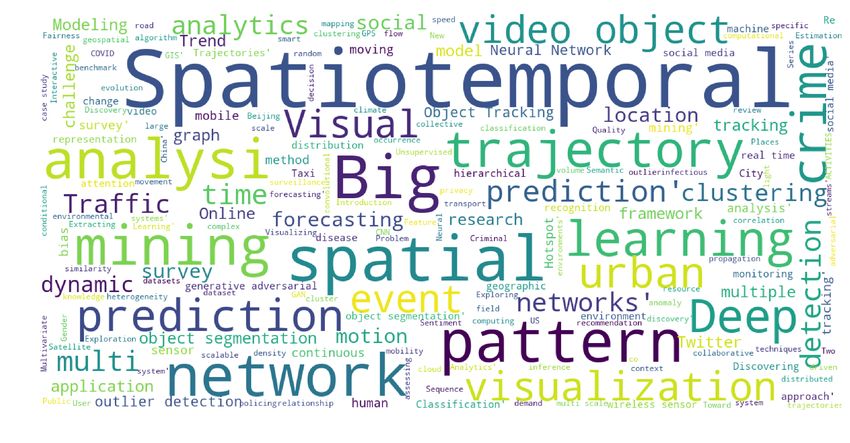
Spatiotemporal Data Mining: A Survey on Challenges and Open Problems                  5

Fig. 2 A taxonomy of the proposed STDM challenges structure. The survey is designed
to cover the STDM related challenges from three different perspectives. We propose to
investigate the general challenges that affect the STDM in terms of relationships, data,
natures and limitations of research. Then, we discuss the STDM tasks and applications
focusing on their related challenges.

are visualised in a word cloud in Figure 3. We included 342 STDM related
work in our survey. These citations are from different publication types, in-
cluding journal articles, conference proceedings, books, book chapters, and
theses. Figure 4 compares between the different ranks and quartiles of the in-
dexed journal articles and conference proceedings. It shows that Q1 journals
are the most cited with 48 percent, followed by A* ranked conferences with
29 percent. The ranks and quartiles are calculated at the Scimago Institutions
Rankings (SJR) 1 and Computing Research & Education (CORE) 2 in De-
cember 2020. We focused the search process on high ranked journals such as:
IEEE Transactions on Big Data, ACM Transactions on Intelligent Systems and
Technology, Cartography and Geographic Information Science, IEEE Transac-
tions on Knowledge and Data Engineering, Neurocomputing, and Transactions

 1   https://www.scimagojr.com/
 2   http://portal.core.edu.au/conf-ranks/
6               Spatiotemporal Data Mining: A Survey on Challenges and Open Problems

Fig. 3 A word-cloud visualisation of the most frequent used search keywords.

Fig. 4 Related work distributions for journal articles and conference proceedings.

in GIS. We also covered a set of highly influential conferences such as ACM
SIGKDD International Conference on Knowledge Discovery and Data Mining,
Proceedings of the IEEE Conference on Computer Vision and Pattern Recog-
nition (CVPR), IEEE International Conference on Data Engineering (ICDE),
IEEE Visualization Conference, AAAI Conference on Artificial Intelligence,
International Joint Conference on Artificial Intelligence (IJCAI), and interna-
tional conference on Ubiquitous computing. The majority of the cited papers,
85 percent, are published in the last ten years. Figure 5 shows the distributions
for the citation of each year between 2011 and 2020.
Spatiotemporal Data Mining: A Survey on Challenges and Open Problems          7

Fig. 5 Related work distributions for years from 2011 to 2020.

3 General STDM Challenges and Research Gaps

There are various factors causing difficulties in STDM. We identify and list
them as follows:

1. Spatiotemporal objects relationships that are complex and implicit.
2. STDM requires interdisciplinary effort and integration of various hetero-
   geneous datasets and multiple data mining algorithms.
3. Spatiotemporal region discretisation problem caused by the scale and the
   zoning effects on the data mining results.
4. Data characteristics such as heterogeneity and dynamicity.
5. Further Efforts Needed in STDM for data representations, advanced mod-
   elling, visualisation, and comprehensiveness.

Figure 6 presents these general challenges using a cause-and-effect diagram
while citing related literature that explains further the used terminologies. In
the next subsections, each of these challenges is discussed.

3.1 Spatiotemporal Relationships

Spatiotemporal objects that exist in one area or during the same time and
share similar characteristics are often related. Finding relationships between
objects is helpful in different tasks such as spatiotemporal hotspot prediction
[6]. However, discovering valuable relationships from spatiotemporal data is
more challenging compared to traditional numerical and categorical data be-
cause of the complex data characteristics. The next sub-sections describe three
of these characteristics of spatiotemporal relationships, namely; complexity,
implicitness, and non-identical distributions.
8              Spatiotemporal Data Mining: A Survey on Challenges and Open Problems

Fig. 6 Cause-and-effect diagram of STDM general challenges. The figure shows a taxonomy
of STDM challenging issues.
Spatiotemporal Data Mining: A Survey on Challenges and Open Problems           9

3.1.1 Complexity

The complexity of spatiotemporal relationships poses difficulty to extracting
spatiotemporal patterns [245, 247]. [213] stated that this complexity stems from
the fact that spatiotemporal data are discrete representations of what are, in
reality, continuous in space and time. For example, traffic sensing devices that
are fixed in roads capture data of moving vehicles in certain locations while
these vehicles are continuously moving. Moreover, co-located spatiotemporal
objects influence each other and hinder the detection of relationships. In other
words, the pattern of a moving object might be affected by nearby objects
such as a car’s direction, speed and acceleration are influenced by other cars
around it.

3.1.2 Implicitness

Non-spatiotemporal data have explicit relationships represented through arith-
metic relations, such as ordering, instance-of, subclass-of, and member-of. On
the contrary, relationships between spatiotemporal objects are implicit [246].
Spatial relationships are built based on qualities or feature such as distance,
volume, size and time. These relationships can occur among points, lines, re-
gions or a mixture of them. For instance, Figure 7 shows that topological
relationships between two regions, include, disjoint, overlap, contains, covers,
meet, equal, inside and covered-by [54]. A spatiotemporal point can co-locate
with another point. A line in a spatiotemporal environment can intersect, over-
lap, touch or be within another line or spatiotemporal area. For example, in
the case of migrant birds, flying birds can be described as a complex network
of multiple spatiotemporal lines. The work in [139] analysed a daily temporal
resolution for migration trajectories of 118 migratory bird species from 2002
to 2014. In order to address this issue, the spatiotemporal relationships can
be transformed into traditional relationships mined using classical data min-
ing methods. However, this process causes information losses which inevitably
preclude detecting subtle relationships. For example, in the case of traffic mon-
itoring, using distributed sensing systems capture micro-scale sensing data for
the whole sensed area; while using fixed traffic sensors can only collect trans-
action data for anonymous moving objects’ speed, direction and acceleration.
The former represents the actual, but implicit, movement patterns. The latter
aggregates the sensing data. This data aggregations leads to loss of data about
tracking the relationships between them.

3.1.3 Non-independent and Non-identical Distribution

Spatiotemporal data objects have positive autocorrelation or dependency. Nearby
things in space and time tend to be related and more similar than distant
things. In moving cars, for example, there are many dependent variables such
as location, direction, connectivity and temporal attributes [181]. For instance,
if there is heavy traffic in an intersection at 4 pm, the chances are that there
10             Spatiotemporal Data Mining: A Survey on Challenges and Open Problems

Fig. 7 Examples of topological relationships between two areas.

will be some traffic at 4.01 pm as well. Moreover, opportunity contributes
more to the probability that a spatiotemporal pattern to occur [4]. For exam-
ple, crime often occurs when a criminal and a victim are found in the same
location and time. This is an autocorrelation as opposed to classical data that
are independent and identically distributed. The autocorrelation between spa-
tiotemporal objects degrades the performance of data mining algorithms [30].
Additionally, measuring the spatiotemporal autocorrelation in large datasets
is computationally expensive.
Identifying spatiotemporal distribution characteristics is useful for patterns
discovery. It is also important for detecting regularly repeating relationships
between spatiotemporal objects [151]. Spatiotemporal distribution was dis-
cussed in various studies in different domains such as phenology, geology, eco-
toxicology, and criminology. Such studies reported that spatiotemporal data
tend to have a non-identical distribution across space (spatial heterogene-
ity) and over time (temporal non-stationarity). A spatiotemporal dataset may
have geographical regions and temporal periods with distinguishable distribu-
tions [216]. For example, drivers’ behaviours are varying concerning location
and time. Driving seems to be safer in quiet areas and night hours. While it
is expected to be dangerous in crowded areas, especially during rush hours.
Moreover, spatiotemporal data has skewed distribution in different locations
of a city, e.g., a city downtown may have high-volume data than the other
suburbs. This issue can affect the performance of STDM tasks.

3.2 Interdisciplinary and Combined Data Mining

STDM requires interdisciplinary efforts and ever-expanding knowledge from
different domains. For instance, spatiotemporal crime data analysis requires
large-scale macro datasets analysis for socio-economy, socio-psychology, cul-
ture and demography [64], and micro-environmental datasets such as interur-
ban structure, distance, density clusters and tactics to crimes [97]. Other fac-
tors also have been investigated, such as globalisation and social and demo-
graphic change. Figure 8 shows data sources from different domains need to
be combined with crime datasets. This combination enables analyses of crime
patterns and criminal behaviors. Dealing with a variety of data from different
domains requires integrating multiple data mining techniques such as clas-
sification, regression, clustering, and association rules discovery. Using mul-
tiple heterogeneous datasets or utilising multiple data mining algorithms is
Spatiotemporal Data Mining: A Survey on Challenges and Open Problems           11

Fig. 8 Different sources of data needed for crime analysis

known as combined mining [4]. [239, 339] proposed hybrid predictive models
for air quality prediction combining different predictors, e.g., spatial, tempo-
ral, and inflection predictors. [339] considers the sudden change in climate as
an inflecting predictor. This interdisciplinary nature is a challenging issue that
contributes to the complexity of STDM. For example, bird migrations are in-
terrelated to climate, e.g., temperature, humidity and wind; which affects the
forest areas and water quantities; which may be removed and replaced by
urbanisation caused by economic development.

3.3 Spatiotemporal Region Discretization

Before analysing spatiotemporal datasets, spatiotemporal discretisation (or
aggregation) is applied. The discretisation is useful to summarise information
and help in extracting features within a range rather than measuring a single
point [79]. For example, the crime rate cannot be measured for a single spatial
point but requires the aggregation of the crimes occurred in wide areal units.
Spatiotemporal patterns are scale-dependent. They shape variant clusters at
different scales. For example, the crime patterns and rates are affected by
the discretisation scale. Spatiotemporal data can be aggregated at different
levels or areal units. It is not always easy to define the best level to apply
the spatiotemporal region discretisation as the results vary according to the
different areal units. This is defined by [194] as Modifiable Areal Unit Problem
(MAUP). According to [259], MAUP includes the scale effect and the zoning
12             Spatiotemporal Data Mining: A Survey on Challenges and Open Problems

Fig. 9 Spatial scaling between a or b and c and zoning between a and b. The figure shows
the impact of having different scales and zones on the analysis results.

effect. The scale effect would reflect the different statistical measures if the data
were aggregated to different scales of areal units. The zoning effect considers
the change in the borders of different areal units and their effects on the results.
Figure 9 presents the MAUP scaling between a or b and c, and zoning between
a and b. Another efficient method is to discretise the region through a regular
grid with small size cells [78]. The small size is relevant to the region, i.e.,
the cell size could be a fraction of that region. In [78], each trajectory is used
to compute the cell densities. They calculate how many cell points intersect
other neighbourhood points in the trajectory. There are many previous works
in the literature that studied the effects of spatiotemporal discretization on
different applications such as remote sensing [248], physical geography [162],
traffic safety [110], economy [127], health [222], crime [68], and ecology [240].

3.4 Data Characteristics

STDM uses spatial, temporal and non-spatiotemporal or thematic data at
different levels of granularity [4]. This fact introduces various challenging data
characteristics including specificity, vagueness, dynamicity, social, networking,
heterogeneity, privacy and poor quality. These characteristics are explained in
the following subsections.

3.4.1 Specificity

Spatiotemporal data when is used to build a good model for a particular appli-
cation domain may not be useful in another one. For instance, a model that is
built for the bird migrations neither be useful for vehicles movements in a city
nor molecular movement in a microscopic level. This challenge is also applica-
ble to different geographical areas having different nature and characteristics.
Therefore, spatiotemporal models cannot be generalised as they are designed
specifically for certain domains [201].
Spatiotemporal Data Mining: A Survey on Challenges and Open Problems                    13

3.4.2 Vagueness

Spatiotemporal data objects or events have similarities that are important
in different STDM tasks such as clustering. However, these similarities have
different interpretations stem from different criteria. Two similar events may
belong to different classes or be triggered by different patterns. Figure 10
shows an example where trajectories 2 and 3 are similar from the spatial per-
spective, but after adding some semantic information, they become dissimilar.
Because trajectory 2 departs from a train station while trajectory 3 departs
from a company. In contrast, trajectory 1 and 2 appear dissimilar in terms
of their spatial attributes while both of them start, pass by and end at the
same location. This vagueness increases the analysis difficulty and adds fur-
ther modelling and processing complexity in multiple STDM tasks such as
classification, clustering and pattern extraction [245]. Therefore, there is an
increasing need for more research efforts in STDM semantic annotation and
enrichment.

Fig. 10 Vagueness due to data similarities stem from different criteria. Trajectory 2 and 3
have similar spatial attributes. However, they are semantically different.

3.4.3 Dynamicity

Spatiotemporal data require dynamical models to capture the evolution of
their distributions or densities. Figure 11, a, b and c represent three different
time-stamps of moving objects. As can be seen, the distribution of spatiotem-
poral moving objects is changing over time. This dynamic evolution of the
densities can be found in different applications. [9] described the dynamics of
14             Spatiotemporal Data Mining: A Survey on Challenges and Open Problems

Fig. 11 Dynamic changing of the spatiotemporal distribution of moving objects

diseases in populations, [269] discussed the spatiotemporal dynamics of crimi-
nal events, and [120] raised the need to study the spatiotemporal dynamics in
the case of brain transcriptome to better understand the neurodevelopment in
order to predict brain disorders.

3.4.4 Social

Spatiotemporal social datasets describe societies and people daily lives in
different places and eras. Social media platforms contain big data related
to human behaviour, traditions and people lifestyles. The social data such
as text posts or tweets, images and videos are correlated with the socioe-
conomic characteristics. Besides, the growth of sensor technologies produces
large spatiotemporal data such as check-in and geo-temporal tags. Therefore,
spatiotemporal social datasets can be utilised to recognise spatiotemporal pat-
terns in social media data or to predict social trends. Such data can also be
used to discover the causes behind new social phenomena. The spatiotempo-
ral analysis of social data is an evolving area. It has different tasks such as
density estimation [295], collaborative filtering for recommender systems [205,
152] and sentiment analysis [241]. However, recent studies have shown that
such models may have biasness and discrimination against different races and
genders. Spatiotemporal datasets tend to have bias that affects these models.
Buolamwini and Gebru [24] evaluated bias present in automated facial anal-
ysis systems and datasets. They found that the analysed datasets are biased
toward lighter-skinned subjects. Specifically, they categorised the gender and
skin type of two facial benchmarks, namely Adience and IJB-A, according to
their skin-type classification with representations of 86.2% and 79.6% respec-
tivly. They also showed that darker-skinned women are most mis-classified
class with 34.7% error rate. There is a need to capture balanced datasets that
lead to unbiased systems. Bias was also investigated in employee assessment
and hiring algorithms. The work in [209] studied bias in hiring systems. Specif-
ically, they considered bias in data collection and target predictions processes.
The study in [75] proposed datasheets for datasets. These datasheets are de-
signed to avoid bias in data collection and usages.
Spatiotemporal Data Mining: A Survey on Challenges and Open Problems           15

3.4.5 Networked

Spatiotemporal data may be captured from moving objects or devices that
are connected in space and time, such as GPS-tagged fleet of vehicles or an-
imals. They form different types of networks such as in transportation [342,
90], cellular [136], wireless sensors [5], and smart cities [82]. Matching the raw
trajectory data with road networks makes it easier to mine the trajectory pat-
terns. In such a case, the trajectory mining problem is done sequentially of the
sequences the road network edges and stops. However, dealing with networked
trajectory data is difficult due to the influence between the data points and
trajectories in the network, in addition to the enormous volume of data and
the exponential number of expected relationships.
    When raw trajectory data, e.g., GPS readings, are matched to the road
network, dealing with the resulting data is not always difficult. In the litera-
ture, such representation is considered as 1.5-dimensional and finding patterns
and clustering this data is more straightforward in some contexts. For exam-
ple, the problem of trajectory pattern mining could be reduced to the problem
of sequential string pattern mining of the sequences of edge ids of the streets.

3.4.6 Heterogeneity and Non-stationary

Any environment is often affected by continuous change through space and
time. Spatiotemporal data show variation in measurements and relationships
due to the influences of this continuous change. For example, trajectories and
behaviour of road users of a city can vary over space and time. Hence, tra-
jectories vary for cold days compared to sunny days. This variation is known
as spatial heterogeneity and temporal non-stationarity [245]. Thus, most of
the spatiotemporal data tend to have an intrinsic degree of uniqueness that
may cause inconsistencies between a global model and regional models. Conse-
quently, this heterogeneity requires building different mining models for vary-
ing spatiotemporal regions. Otherwise, a global model built from a spatiotem-
poral dataset may not describe well the observed data for a specific space and
particular time [181]. Therefore, finding the best parameters to build local
models is a crucial challenge. The heterogeneity is a challenging issue that
must be considered when analysing spatiotemporal data in many application
domains — for instance, heterogeneity of socioeconomic observations across
regions throughout social network analysis [318].

3.4.7 Limited Access and Privacy

Mining spatiotemporal data is often restricted by limited access due to pri-
vacy issues. Spatiotemporal datasets may contain information about public
behaviours and norms. Service providers can mine these personal data and
discover patterns and trends [79], which may reveal sensitive information.
For example, spatiotemporal trajectories include important data about people
movements, vehicles and mobile calls. Therefore, there is a concern with the
16 Spatiotemporal Data Mining: A Survey on Challenges and Open Problems side effects of STDM on privacy. The research on privacy-preserving STDM focuses on individuals’ and personal data privacy and corporate privacy for governments and organisations. There are different approaches to protect the privacy of the data, such as suppression of the identities of individuals, per- turbation through adding noise or randomising the original data, data saniti- sation, i.e., adding fake records. These methods aim to swap, modify or delete some aspect to protect the data [159, 160]. In this regard, researchers face a double-edged issue, i.e., to protect privacy vs. achieving accurate analysis. 3.4.8 Poor Quality The quality of spatiotemporal data directly affects the results of the analyses. Consequently, it is important to ensure high-quality data before analysing it. This data quality assurance may not be easy to achieve when utilising interdisciplinary data that may be fragmented and distorted in disordered environments. Causes of such poor quality are uncertainties, partial knowledge, and conjectures [4]. For example, STDM on bird migrations, at all times and for all locations, requires climate, water, forests data that are uncertain, sparse and reflect non-measurable aspects. Monitoring the physical world is affected by errors and noise that may be caused by faulty or obstructed sensors [333]. These errors and noise are to be corrected in order not to affect the STDM tasks [264]. 3.4.9 Big Data and Cloud Computing Spatiotemporal data always exist in large volumes. These large volumes are being generated by 3.8 billion people and 8.06 billion devices which are con- nected to the Internet [125]. [274] reported 1ZB of data was created in 2010 and rose to 7ZB in 2014. This fast generation of large spatiotemporal data creates various challenges to overcome including volume, variety, and velocity. Spatiotemporal big data volume refers to the huge size that causes significant challenges in terms of storage and processing [59]. The data volume is growing faster than the computational processing systems [31]. In terms of velocity, spatiotemporal data in most applications are continuous streams of data. As such, they require expensive computational cost for processing [233]. These challenging characteristics of big data cause multiple issues to various STDM and applications. [244] tackled the issue of clustering big spatiotemporal in- terval data, e.g., large parking data. They evaluated spatiotemporal-intervals clusters based on the similarity and balance between them. [211] tackled the heterogeneity issue at a large number of contextual features. They proposed a model for predicting taxi-driver wait-time at airports. [243] utilised a big GPS data of aircraft at the airport. They proposed a framework to cluster the air- craft trajectories incrementally based on such data. [217] developed a location query browse method utilising a large WiFi data of indoor physical and web activities. Such large and varied data have a spatiotemporal dependency and contextual influence on people’s information and physical behaviour.
Spatiotemporal Data Mining: A Survey on Challenges and Open Problems           17

    Cloud computing has emerged to provide support to STDM to tackle differ-
ent challenges in data management, storage, processing, analytics, and visuali-
sation. Cloud computing offers large amounts of resources that enable fast, and
accurate STDM. STDM computational problems are solved using new cloud
technologies such as Hadoop, MapReduce, and Spark, on distributed stor-
age systems. However, distributed frameworks suffer from many limitations
in terms of data sharing, processing scalability, and interactive performance
[157]. Besides, existing cloud solutions have limited support to the visuali-
sation of the GIS big data [280]. Specifically, conventional cloud computing
techniques are not designed to handle the spatiotemporal data. Therefore,
spacial cloud computing techniques have recently been proposed to leverage a
layer of data-as-a-service (DaaS) to virtualise the spatiotemporal data [303].
The advancements of the GIS harnessed the wide availability of the cloud-
based spatiotemporal services [206]. Spatiotemporal data storage and paral-
lel processing are widely provided by open-source cloud systems [307]. Other
technologies such as Esri Geospatial Cloud and Google Earth Engine are also
providing significant Earth observations spatiotemporal data. Overall, spatial
cloud computing aims to solve spatiotemporal issues related to storage and pro-
cessing. It also tends to offer better spatiotemporal data utilisation through the
"as-a-service" paradigm. However, there is a difficulty in representing physical
spatiotemporal phenomena that are continuous via the classical discrete based
cloud approaches. This issue stems from the heterogeneity, dynamic scalability,
and complex distributions of the spatiotemporal data.
   The issues of big data and cloud computing are discussed in different sur-
veys in the literature such as big spatiotemporal data analytics [301], social
media big data analytics [77], deep learning for big data [331], and big envi-
ronment data [261].

3.5 Open problems in STDM Research

There exists a wealth of research in data mining, most of which, however,
focus on extracting knowledge from non-spatiotemporal data. Applying classi-
cal data mining techniques on spatiotemporal data often produces poor results
[245, 275]. Classical data mining focuses on groups of items that satisfy some
rules, e.g., if events are happening together. STDM often analyses events or-
dered by one or more dimensions and focuses on the discovery of relationships
between these ordered events, which adds more complexity to the spatiotem-
poral analysis. STDM deserves further research efforts to address the identi-
fied challenges and to improve the analysis methods and tools. In particular,
STDM requires efforts to develop advanced data representations, modelling,
visualisation, comprehensive STDM approaches, and Fairness, Accountability,
Transparency, and Ethics (FATE).
18 Spatiotemporal Data Mining: A Survey on Challenges and Open Problems 3.5.1 Data Representations Spatiotemporal data representation is an open research problem [266]. There are multiple well-established spatial methods for both object-based and field- based data representation, including vector, raster data structures, spatial joins and indexing, and topological operators. These spatial data represen- tation methods are supported in most of existing Geographical Information Systems (GIS) and spatial database systems. Their focus has been on the evo- lution of objects and fields over time in regards to discrete changes in object evolution and movement. However, this is not enough to cover spatiotemporal events and relationships [234]. The need for new methods to represent the spa- tiotemporal events and relationships is important due to its impact on STDM modelling [53]. Recent advances in deep learning have introduced spatially- structured networks such as graph convolutional networks [86] and recurrent neural networks [212]. 3.5.2 Advanced Modelling One important research direction in STDM is to develop new techniques for modelling the spatiotemporal data. For instance, noticeably, most existing hotspot detection methods produce poor results when they depend only on high-density locations while ignoring the temporally related attributes, e.g., occurrence date and time, of the clustered objects. Neglecting the temporal aspects when analysing and building models from spatiotemporal data and fo- cusing only on spatial attributes leads to unfavourable outcomes. Despite the large volume of work in GIS, there is a little support of temporal data min- ing in popular GIS [225]. The temporal pattern discovery remains an under- explored area [188]. Spatiotemporal pattern extraction methods are not able to accurately predict a pattern that may happen in a specific time because of disregarding the location and time-stamp together [6]. [70] proposed a hy- brid model combining a Bayesian network and a neural network to predict car speeds. The spatial and temporal correlation among the traffic variables led to better results. Moreover, the thematic attributes are important to discover hid- den knowledge in the spatiotemporal data. [51] improved accuracy of visual clustering by considering both the temporal and thematic information with spatial information in their spatiotemporal data. Besides, modelling real-time spatiotemporal data is challenging when they are sporadically observed. This issue means that the spatiotemporal sampling is irregular such as in clinical patient time-series data. The work in [44] proposed a continuous-time Gated Recurrent Unit based on the Neural Ordinary Differential Equations [32] and a Bayesian update network. The proposed methodology encodes the continu- ity and dynamics of the sporadic multidimensional observations. Capturing both global and local patterns is an essential objective of STDM modelling. DeepGLO [236] is proposed as a deep forecasting method to think globally and act locally. It combines a global matrix factorisation with local temporal fea- tures. Also, temporal information is useful in flow-estimation for applications
Spatiotemporal Data Mining: A Survey on Challenges and Open Problems            19

such as video restoration. Existing methods mostly fails to capture long-range
temporal features. Establishing spatiotemporal dependencies is challenging as
well. Spatiotemporal Transformer Network process multiple frames at once
to solve the occlusion issues in estimating the optical flow [130]. Generative
Adversarial Networks (GAN) have also utilised for spatiotemporal modelling,
simulation and data generation [73]. GANs are used to process different data
types such as trajectories [167, 279], events [147, 315], time series [336, 80] and
spatiotemporal graphs [71].

3.5.3 Visualisation

Visualisations in data analysis are important for the decision-making as they
visually summarise and present results in digestible and easy to understand
forms. Thus, it is useful to develop new approaches tailored to visualising the
dynamic spatiotemporal data and the analyses results. GIS applications and
current research work still focus on developing techniques for spatial visu-
alisation, while less consideration is given to spatiotemporal [310]. This gap
requires more efforts to develop effective methods that can produce realistic,
smoothing and dynamic visualisation. Recently, online news sources have pro-
duced large amounts of text data. One major issue in such data is visualising
spatio-textual, and spatiotemporal online news trends [122]. STDM methods
can also be employed to visualise 3D active motions. The work in [231] pro-
posed to project high-frequency patterns on moving objects to visualise their
3D motion. Inspired by the human visual system, their method integrates light
rays over time. Besides, spatiotemporal visualisation methods are essential to
observe and analyse urban activities and behaviours. The authors in [223] vi-
sualised the spatiotemporal and directional trends in urban activities. They
examined both city and district levels using location-based social data. The
work in [232] Spatiotemporal geo-visualisation method for dynamic data of
the criminal activity. Data-driven approaches have recently been developed to
estimate and visualise deficiencies in medical resources during the COVID-19
pandemic [238].

3.5.4 Comprehensive Approaches

The nature of STDM necessitates the development of comprehensive and in-
tegrated spatiotemporal models. For example, to detect spatiotemporal crime
hotspots, some other spatiotemporal tasks may be needed, such as cluster-
ing and outliers detection. Existing STDM approaches often focus on certain
problems, and they do not introduce comprehensive spatiotemporal solutions
[185]. Future work in STDM ought to consider the interplay among different
data types and various domains.
20               Spatiotemporal Data Mining: A Survey on Challenges and Open Problems

3.5.5 Fairness, Accountability, Transparency, and Ethics (FATE)

The attention around societal concerns of fairness, accountability, transparency,
and ethics in machine learning and data mining has seen a noticeable increase
recently. These concerns include amplifying genders, denying people services,
and racial biases [52]. Web search engines results might be biased or offensive
when, for example, they contain misbeliefs or posting undesirable behaviours
[193]. Retrieving the right information that are considered fair in both spatial
and temporal dimensions is not an easy task as what is considered an offensive
to a specific group may change over location and time. Buolamwini and Gebru
[24] evaluated bias present in automated facial analysis systems and datasets.
They found that the analysed datasets are biased toward lighter-skinned sub-
jects. The work in [209] reported that bias exists in employee-hiring systems.
The work in [18] studied bias in Natural Language Processing systems, and
found that existing methods are inferior when it comes to mitigating bias.
People with disabilities (PWD) such as hearing impairments are directly im-
pacted by automated systems like speech recognition systems. [83] states that
such systems "may not work properly for PWD, or worse, may actively dis-
criminate against them." Microsoft has released Fairlearn 3 [17], a toolkit to
help data scientists and developers mitigate fairness-related issues. Later in
this paper, we discuss different FATE related studies in multiple sections such
as in STDM predictive modelling, public safety, mobility, environment, and
Smart IoT applications.

4 STDM Task-related Challenges

STDM has different tasks, such as prediction, clustering, hotspot detection,
pattern discovery, outlier analysis, visualisation, and visual analytics. These
tasks are important in different applications such as understanding the be-
haviour of moving objects like people, birds, animals and vehicles [107]. The
next sub-sections explain the challenging issues related to these STDM tasks.

4.1 Spatiotemporal Prediction

Data mining predictive models aim to predict target variables based on learn-
ing from annotated features of observations. These models can be either clas-
sification models or regression models. Classification models are for categor-
ical or discrete targets, and regression models are for continuous targets. In
STDM, the prediction task formulations are based on the input and output of
spatiotemporal data representations. For examples, predicting an output vari-
able, continuous or categorical, using time series at different locations in raster
[113], predicting a scalar output using the complete information in raster data
[316], or predicting spatiotemporal responses using observations collected at
 3   https://fairlearn.github.io/
Spatiotemporal Data Mining: A Survey on Challenges and Open Problems         21

other time-stamps in spatial neighbourhoods [126]. STDM prediction methods
use extracted discriminative features, e.g., average speed, acceleration, dura-
tion, distance, length and direction, from labelled spatiotemporal data to train
standard classifiers or regressors. The prediction can be done by single models
e.g., Decision Trees (DT) [129], Support Vector Machines (SVMs) [1], or en-
sembles, e.g., Random Forest (RF) [200] or deep learning, e.g., Convolutional
Neural Network (CNN), Recurrent Neural Network (RNN) [168, 149, 196, 328].
Other STDM tasks such as clustering can be applied to extract features for
prediction. For instance, TraClass [142] applied segmentation and clustering
for the region and sub-trajectory feature extraction, then trained an SVM
classification model. STDM trajectory-based prediction estimates the future
location or route of moving objects using different methods such as the Hid-
den Markov Model (HMM). Predictive models predict the next location of
a trajectory to build more accurate decisions and deliver more precise rec-
ommendations. There are two different approaches proposed based on the
moving object or other neighbours, as well as a hybrid approach that com-
bines both [313]. Recently, deep learning-based models have been applied to
tackle various spatiotemporal prediction problems, e.g., crowd flow, car-hailing
supply-demand, and traffic predictions [60]. Here, the models take into account
temporal instances, near and far spatial dependencies, and other influential
external factors for the spatiotemporal prediction problem. [228] tackled an-
other problem of predicting continuous trajectory, not only a single future
location. Based on a user’s morning trajectory, their model can predict the
whole-day trajectory of the user. The spatiotemporal dependencies between
multiple contexts cause an imbalance problem as one spatiotemporal event can
be rare or infrequent compared to other [210]. This data imbalance problem
affects the accuracy of the STDM prediction task. The multi-scale effect or the
spatiotemporal discretisation issue also poses another challenge as the results
of the spatiotemporal classification or regression vary based on the different
scales and zones. In order to train a prediction model, spatiotemporal features
must be generated using data aggregation. However, the aggregation process
can be challenging in building multiple relationships between spatiotemporal
objects to build the feature sets. Moreover, the process of generating spa-
tiotemporal features is resource and time-consuming. Spatiotemporal Kriging
is an important geo-statistical regression-based interpolation method with a
spatiotemporal covariance matrix and variograms. Simply, it can predict the
target values at unobserved locations based on observations at other locations,
even with noisy data. However, Kriging suffers from the limitation of assum-
ing the isotopic nature of the random variables [245]. Recently, multiple deep
learning-based studies focused on the spatiotemporal trajectory classification,
such as using Long Short Ten Memory (LSTM) networks for sequence classi-
fication. However, these approaches fail to consider both spatial and temporal
information simultaneously. For example, Time-LSTM handles trajectories’
temporal information and neglects the spatial ones [164]. Explanation of the
spatiotemporal predictions is another issue of concern. Most existing prediction
models are mostly black boxes and, in many decision making applications such
22             Spatiotemporal Data Mining: A Survey on Challenges and Open Problems

Fig. 12 An example of explaining a model prediction of flue based on different symptoms,
from LIME [220].

as medical diagnosis, understanding of the reasoning behind the predictions
are required. The authors in [220] proposed LIME (Local Interpretable Model-
agnostic Explainations), a method that explains model predictions by learning
an interpretable model locally around the predictions. Figure 12 shows the pro-
cess of explaining model predictions by using different symptoms to predict
that a patient has a flu. The proposed algorithm tend to identify which symp-
toms contribute to the model predictions. For example, sneeze and headache
led to the flu prediction while ’no fatigue’ is not relevant.

4.2 Spatiotemporal Clustering and Hotspot Detection

In contrast with classification, clustering partitions a set of spatiotemporal ob-
jects into similar groups based on their characteristics without having labelled
datasets. STDM clustering methods aim to determine the cluster of a given
object based on different features, including spatiotemporal ones. For example,
trajectory clustering may harness the similarities using features such as route
origins and destinations. There are different approaches used in STDM clus-
tering such as partitioning, hierarchical and density-based. Many statistical
models are also used such as HMM, spatiotemporal extensions of the density-
based spatial clustering of data with noise (ST-DBSCAN), and time-focused
clustering of trajectories of moving objects (T-OPTICS) [131]. TraClus [143]
algorithm works on parts of trajectories in order to define similar trajectories
based on visiting the same type of places. Clustering spatiotemporal data is af-
fected by the large size of data which leads to a trade-off between the accurate
clustering results and computational cost [115]. It is also affected by noise and
outlier patterns. Also, shapes and sizes of patterns add more complexity to
spatiotemporal clustering. Spatiotemporal clustering differs according to the
data types, such as clustering locations based on thematic attributes over time,
clustering moving objects and clustering trajectories. Since a trajectory is a
sequence of time-stamped point locations of a moving entity through space,
clustering moving trajectories is complex due to their continuous object move-
ment and evolving. Thus, more efforts are needed to discover the interaction
and change in the spatiotemporal trajectory movements in order to achieve
more accurate clustering [107]. Such efforts may propose modifications of exist-
ing clustering algorithms to make them more suitable for spatiotemporal data
Spatiotemporal Data Mining: A Survey on Challenges and Open Problems          23

[16]. Another open issue related to spatiotemporal clustering approaches is
related to their evaluation techniques. While traditional clustering approaches
require computations in single Euclidean space, the spatiotemporal clustering
approaches need computations in multiple spaces [244]. Besides, computing
the trajectory similarity based on point matching results in low-accuracy re-
sults [156]. Specifically, such methods handle two different point-sequences in
a different way albeit they belong to the same trajectory.
    On the other hand, spatiotemporal hotspots refer to locations that contain
an unexpectedly high number of objects in a time [46]. The spatiotemporal
hotspot detection is complex because the number and features, e.g., size, shape
and number of objects, of hotspots are unknown. STDM hotspot detection task
is utilised for identifying dense conglomeration of events both in space and
time in applications such as the outbreaks of diseases [23, 65]. [138] proposed
a spatial scan statistical (SSS) method for hotspot detection. The method
explores the potential region of multiple circular-shaped sizes. The hotspot
is defined as the region with a significantly high incidence of points. Later,
multiple methods were proposed to generalise this SSS for spatiotemporal
data [38]. However, the problem is still complex as results of shapes of regions,
background distributions, and speeds of search. STDM hotspot detection is
also utilised in various applications such as public emotion analysis, public
safety, and traffic management. [344] proposed a hotspot detection method for
the analysis of public sentiment using geotagged photos. The proposed method
detects the emerging concentrations of certain sentiment class. [173] proposed
a hotspot detection for political violence. The proposed method tries to solve
the problem of uncertain and less predictable violence against civilians. STDM
hotspot detection is employed to explore the potential locations and times
of traffic accidents. [224] proposed a spatiotemporal network kernel density
estimation. Using the STDM hotspot detection methods such as scan statistics
and kernel density estimation are not useful in such traffic accidents cases.
This is because these methods focus on Euclidean space and ignore traffic-
related aspects such as constrained road networks [224]. Research studies were
proposed to detect hotspots in the network space such as linear route detection
which focuses on the spatial aspect and neglects the temporal dimension.

4.3 Spatiotemporal Pattern Mining

Spatiotemporal patterns represent the details of frequent behaviors in space
and time. STDM pattern mining works on discovering hidden information, i.e.,
occurrences in space and time, such as movement patterns from trajectories
of spatiotemporal objects. Multiple methods were proposed to mine several
types of movement patterns including; periodic or repetitive patterns that
concern regular movements which are repeated at certain time intervals such
as bird migration [324], and frequent pattern mining to discover the sequence
of visited locations and the transition times between them [95]. Trajectory
pattern (T-pattern) is an example of frequent pattern defined by [78] as a
24 Spatiotemporal Data Mining: A Survey on Challenges and Open Problems set of trajectories that visit the same sequence of places consuming similar transition time. T-pattern can be mined by analysing sequences of regions of interest with time-stamps [14] or discretisation of space to determine the regions of interest [78]. Group pattern mining tends to identify movement pat- terns for groups of objects that move together in near space and time. Several group patterns were proposed based on spatiotemporal closeness constraint, group construction and members’ properties. Examples of group patterns in- clude flock [276], convoy [300], swarm [251], leadership [7] and chasing [169]. They were also studied as mixed-drove or co-occurrences [282, 28] for time- unordered patterns, spatiotemporal cascades [182] for partially time-ordered patterns, and spatiotemporal sequential patterns [172] for totally time-ordered patterns. Mining of spatiotemporal pattern mining has key challenges. One ma- jor challenge is that there are no explicit transactions in the spatiotemporal datasets. The number of possible patterns is exponential, and there is a po- tential for over-counting. Accordingly, these issues lead to a trade-off between the accuracy of the output and computational efficiency. There are different statistical methods used for mining the spatiotemporal co-location patterns, such as cross-K-function, spatial regression model [39] and mean nearest neigh- bour distance [252]. However, these statistical methods are computationally expensive due to the exponential number of candidate patterns. Furthermore, discovering spatiotemporal association or co-occurrences from trajectories is challenging due to temporal duration, different moving directions, and wrong locations. 4.4 Spatiotemporal Outlier Detection In contrast to pattern mining, STDM outlier detection aims to find unusual patterns that do not follow the common path, using a set of whole trajectories [325] or parts of trajectories [166]. Like prediction, STDM outlier detection methods usually come after other data mining methods; especially clustering to discover objects that are not similar to any cluster. STDM classification has also been used for outlier detection based on predefined features, e.g., location, speed, angle and direction, and utilising various distance measures [319]. Spa- tiotemporal outlier detection aims to discover spatiotemporal objects that are discontinuous or inconsistent with their space and time neighborhoods. Discon- tinuity means that the thematic or non-spatiotemporal attributes of the outlier objects significantly deviate from other observations [213]. Outlier detection depends on different statistical methods which are affected by several chal- lenging issues related to model generalisation and scalability, lack of effective spatiotemporal data representation methods, and low focus on interpretabil- ity. Although the mathematical and statistical foundation of spatiotemporal outlier detection is important, most previous researches focus only on the computation efficiency and intuitive analysis [3]. Additionally, spatiotemporal outliers can be important and refer to interesting events, e.g., the formation of cyclones, or they can be noise [266].
You can also read


