EARLY WARNING & TSUNAMI - A Feasibility Study for an Offshore Geophysical Monitoring Network - Early Warning Offshore Cascadia
←
→
Page content transcription
If your browser does not render page correctly, please read the page content below
EARTHQUAKE
& TSUNAMI
E A R LY WA R N I N G
ON THE CASCADIA
SUBDUCTION ZONE

A Feasibility Study for an
Of fshore Geophysical Monitoring Network
Earthquake and Tsunami
Early Warning on the Cascadia
Subduction Zone
A Feasibility Study for an Offshore
Geophysical Monitoring Network

PREFACE
This study advances efforts to implement earthquake early warning along the U.S. West
Coast. An optimized detection and warning system must be adapted to the local geology
and particular earthquake risks for a region. Compared to other plate boundaries, residents
of subduction zone environments likely benefit the greatest from earthquake early warning
because the population is likely to receive the longest warning times. This is because the
major inland populations are far from the earthquake source, which lies almost entirely
offshore. But subduction zones present a challenge: the geophysical network that detects
the earthquake is limited to the land, rather than surrounding the earthquake source region
offshore. Subduction zones also pose a second major hazard in the form of a tsunami that
is frequently triggered by the offshore earthquake. Therefore, the timeliness, accuracy, and
reliability of earthquake and tsunami early warning in subduction zones, such as found
in the Pacific Northwest, would be enhanced by offshore geophysical instrumentation.
However, offshore instrument networks are technically challenging to design, install, and
maintain.

The feasibility and design of an offshore geophysical network for earthquake and
tsunami early warning in the Pacific Northwest was evaluated by a team of scientists and
engineers at the University of Washington with support from the Gordon and Betty Moore
Foundation. The team’s goals were to (1) consider the justification for such a system, (2)
identify the high-level system specifications, (3) evaluate current and emerging technologies,
(4) determine the feasibility and approximate costs of illustrative designs, and (5) make
recommendations about the path forward. To inform the study, a workshop of over 100
participants was organized after some preparatory work (Wilcock et al., 2016). Attendees
were drawn primarily from academia, but representatives from federal agencies, industry,
the emergency management community, and the media were also present (Schmidt et al.,

                                                                 Offshore Earthquake and Tsunami Early Warning   1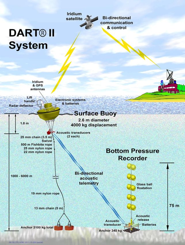
2018). The deliberations and recommendations of the workshop were important in guiding
                         the completion of the study. This report and its supporting documents present the study’s
                         results.

                         The instrument network designs presented here are neither final nor optimized, but
                         rather are illustrative of options that utilize established and emergent approaches. While
                         the report notes the necessity of incorporating an offshore geophysical network into a
                         comprehensive strategy for preparedness, education, warning, and response, it does
                         not present a holistic mitigation plan, nor does it explore in any detail how offshore data
                         would be integrated with existing warning systems that are operated by the United States
                         Geological Survey (USGS) and the National Oceanic and Atmospheric Administration
                         (NOAA). This report is best viewed as a resource on the scientific and technical
                         considerations, as well as the societal benefit, for earthquake and tsunami detection
                         in subduction zones, such as in Cascadia and similar locations across the planet with
                         populations at risk.

                         AUTHORS
                         David Schmidt, Earth and Space Sciences, University of Washington
                         William Wilcock, School of Oceanography, University of Washington
                         Randall LeVeque, Applied Mathematics, University of Washington
                         Frank Gonzalez, Earth and Space Sciences, University of Washington
                         Geoffrey Cram, Applied Physics Laboratory, University of Washington
                         Dana Manalang, Applied Physics Laboratory, University of Washington
                         Mike Harrington, Applied Physics Laboratory, University of Washington
                         Emily Roland, School of Oceanography, University of Washington
                         Paul Bodin, Pacific Northwest Seismic Network, University of Washington

                         ACKNOWLEDGMENTS
                         This work was funded by the Gordon and Betty Moore Foundation through grant
                         GBMF5231 to the University of Washington. Report editing and layout by Brian Rasmussen
                         and Kim Reading. Graphic design and visualizations by Hunter Hadaway. The authors thank
                         Kate Moran, Diego Arcas, Christian Meinig, and Diego Melgar for thoughtful comments on
                         an early draft.

                         RECOMMENDED CITATION
                         Schmidt, D., W. Wilcock, R. LeVeque, F. Gonzales, G. Cram, D. Manalang, M. Harrington, E.
                         Roland, and P. Bodin. Earthquake and Tsunami Early Warning on the Cascadia Subduction
                         Zone: A Feasibility Study for an Offshore Geophysical Monitoring Network. Seattle: University of
                         Washington, 2019, 81 pp.

2   Offshore Earthquake and Tsunami Early Warning
Table of Contents
5      EXECUTIVE SUMMARY
7      INTRODUCTION
11     OFFSHORE EARLY WARNING: MOTIVATIONS AND BENEFITS
			      The Threat of Subduction Zone Earthquakes and Tsunamis
			      Early Warning Systems
			      Early Warning Systems Using Offshore Observations
			      Early Warning Saves Lives and Reduces Damage
			      Early Warning as Part of a Holistic Loss Reduction Plan
			      An Opportunity for New Scientific Insights

31     INSTRUMENTS TO DETECT AND MONITOR OFFSHORE EVENTS
			      Detecting earthquakes and tsunamis and measuring deformation

38		   SYSTEM REQUIREMENTS
			      Requirements for earthquake and tsunami early warning and for monitoring and scientific research

42		   INSTRUMENT PLATFORMS AND NETWORK DESIGN
			      Cabled Systems
			      Moored Buoys
			      Mobile Platforms
			      Wireless Seafloor Networks
			      Emerging Platforms and Auxiliary Technologies
			      Risks
			      Summary of Design Options

59     IMPLEMENTATION PLAN
			      Community Engagement
			      Preparatory Scientific Studies
			      Instrument Network Design Research
			      Funding
			      Installation Timeline

71     SUMMARY
73     REFERENCES
78     APPENDIX A: GLOSSARY OF TERMS
80     APPENDIX B: ACRONYMS
81     APPENDIX C: RESOURCES

                                                          Offshore Earthquake and Tsunami Early Warning     3
4 Offshore Earthquake and Tsunami Early Warning
Executive Summary
Subduction zones are responsible for the largest earthquakes on our planet
and generate the largest tsunamis. The nearshore communities of the
Pacific Northwest are at great risk from these natural hazards. Early warning
systems provide seconds-to-minutes of warning for people and automated
systems to take actions that decrease deaths, injuries, and damages. Existing
tsunami early warning systems, such as NOAA DART buoys, are designed
primarily for far-field tsunamis that propagate across the world’s oceans on
time scales of hours. Near-source tsunami warning is challenging because
nearfield observations are rarely available to characterize the disturbance
of the sea surface quickly and to provide an accurate prediction of the
immediate impacts. Efforts are underway to obtain rapid near-source
tsunami predictions from land-based measurements of earthquake rupture,
but the most accurate and complete predictions will require offshore
observations. On the U.S. West Coast, earthquake early warning is now
provided by terrestrial geophysical networks that contribute data to the
ShakeAlert system. But the timeliness and accuracy of the warning are
diminished for offshore earthquakes because of the great distance between
the offshore source zone and the instruments on land.

For coastal residents, earthquake early warning helps ensure that individuals
secure themselves prior to severe ground shaking and avoid injury, so that
they are then able to evacuate areas at risk from the tsunami. Offshore
instruments would improve earthquake early warning accuracy and reduce
the mischaracterization of earthquakes. For many coastal communities,
seconds matter, because the tsunami may arrive before an evacuation can
be completed. A tsunami early warning can be more accurate and timely if it
is informed by an earthquake early warning, as this information can be used
to initiate predictive models that forecast the height, arrival time, and inland
flooding of the incoming tsunami wave. Offshore instruments can also detect
and warn of tsunamis that might be triggered from submarine landslides
that produce no discernable shaking or slow earthquakes that produce
diminished shaking relative to their magnitude and fail to alert coastal
residents of a potential tsunami risk.

                                                        Offshore Earthquake and Tsunami Early Warning   5
Installing instruments in subduction zones presents logistical and
                         engineering challenges because the offshore source zone is inaccessible
                         and inhospitable. A variety of instruments can be used to detect an
                         emergent earthquake and tsunami, with ocean bottom seismometers
                         and pressure gauges being the most established. Research is needed to
                         understand whether seafloor pressure gauges are sufficient to measure
                         an emergent tsunami within the source zone or whether they must be
                         complemented by direct observations of sea surface displacement.
                         One technical challenge when building an offshore system is providing
                         reliable power and communications. Cabled systems are the most mature
                         technology for enabling both earthquake and tsunami early warning from
                         offshore instruments, but at considerable upfront cost. Moored buoys
                         are well demonstrated for tsunami warning, but their latency is likely too
                         large for earthquake early warning. A hybrid approach that uses multiple
                         technologies, such as a combination of cabled and buoy systems, may be
                         ideal because benefits of each technology can be maximized while the risks
                         and costs minimized. Emerging technologies may provide new solutions,
                         but significant research and development is required to evaluate these
                         approaches and demonstrate that they are scalable.

                         The implementation of an offshore instrument network will require the
                         cooperation and support of many, diverse stakeholders. Extensive research
                         and development is needed to ensure that an offshore system is optimally
                         designed and well implemented. Early warning systems must be developed
                         in synergy with other planning, mitigation, and educational activities to
                         maximize regional preparedness, response, and resilience.

6   Offshore Earthquake and Tsunami Early Warning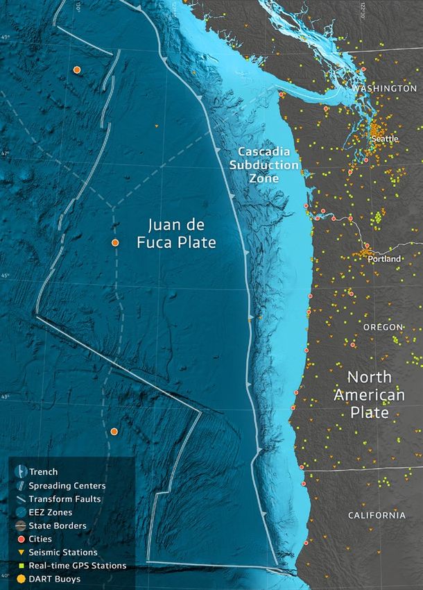
Introduction
The western parts of Northern California, Oregon, Washington, and British Columbia will
experience a major earthquake and tsunami that will cause extensive property damage
and loss of life. The source of the threat to the Pacific Northwest is the Cascadia subduction
zone, which marks the boundary between the North American continental plate and the
Juan de Fuca oceanic plate. As these two plates converge at a rate of 1.5 inches/year, the
Juan de Fuca plate slides beneath the North American plate. The major fault that forms
between these two plates remains locked for many hundreds of years, allowing stress to
build in the Earth’s crust. Eventually, the fault will fail and the plates will lurch past each
other, producing an earthquake as large as magnitude 9. During the event there will be
several minutes of violent shaking strong enough to knock people off their feet and destroy
many buildings. The vertical movement of the seafloor during this event will raise the sea
surface suddenly, initiating a large tsunami. Tsunami waves will strike the nearby coast of the
Pacific Northwest 10–20 minutes after the earthquake begins. Wave heights may be 10–50
feet at exposed coastal locations proximal to the source, with secondary arrivals continuing
to inundate the coast for many hours. Subduction zone earthquakes are particularly
devastating because they are often compound natural disasters. The earthquake generates
a tsunami and produces widespread regional destruction that challenges emergency
responses and hinders post-event recovery.

While scientists know that stress is accumulating now and will eventually result in a large
earthquake and tsunami, it is not known when this event will occur. The USGS estimates
the probability is 10–14% (up to a 1-in-7 chance) that an earthquake of magnitude 8 or
greater will occur on the Cascadia subduction zone in the next 50 years (Petersen et al.,
2002). Independent studies report similar probabilities in the range of 11–17% in the next 50
years (Kulkarni et al., 2018; Onur and Seemann, 2004). The geologic record of paleoseismic
deposits offshore suggests that the probabilities may be higher (21–42%) on the southern
section of the subduction zone (Goldfinger et al., 2012). For comparison, the lifetime odds
of a male being diagnosed with prostate cancer or a female being diagnosed with breast
cancer (1-in-8; Howlander et al., 2019) are about the same odds as for a resident of the
Pacific Northwest experiencing a major subduction zone earthquake in their lifetime.
Unlike these diseases, however, when an earthquake strikes, it will affect the well-being,
infrastructure, and economy of the entire region instantly; 100% of the population will be
impacted. There are simple strategies our society can take to mitigate the potential impacts
of a large earthquake and tsunami in the Pacific Northwest. All, however, require advanced
planning and infrastructure investment by state and federal governments, in partnership
with the private sector.

Actions that can help the region prepare and mitigate potential losses from a subduction
zone earthquake and tsunami include updating building codes to reflect our evolving

                                                                  Offshore Earthquake and Tsunami Early Warning   7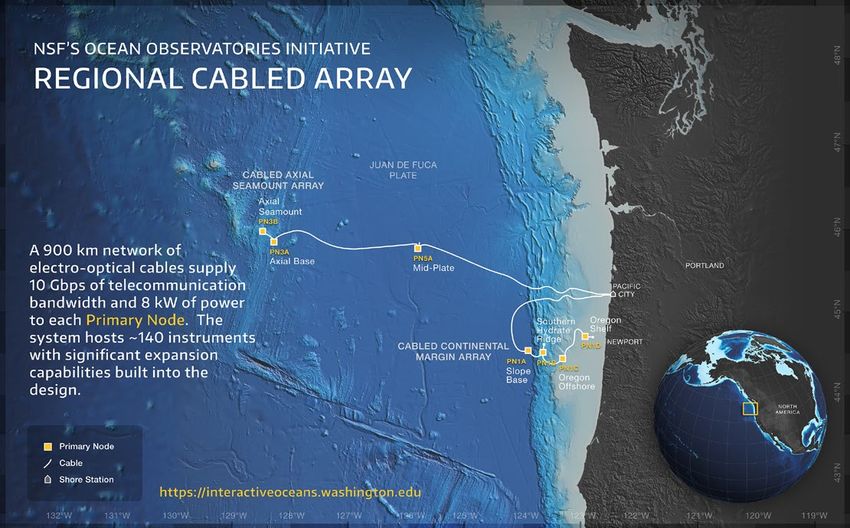
understanding of the hazard, constructing vertical evacuation structures on the coast
                                 where tsunami evacuation is hindered by geographic barriers, retrofitting unreinforced
                                 buildings, hardening infrastructure and transportation systems, educating the population,
                                 and developing post-disaster response and recovery plans. There is the potential to
                                 minimize injuries, deaths, and damage by taking pre-emptive actions in the seconds before
                                 strong ground shaking arrives or the minutes before tsunamis arrive on the coast. Early
                                 warning systems, such as the USGS ShakeAlert (Given et al., 2014), are designed to inform
                                 the public of an impending event, based on real time seismic data, so that people and
                                 automated systems can take appropriate actions.

                                 Early warning systems are most effective when designed to sense the beginning of an
                                 earthquake or tsunami as quickly as possible, maximizing the warning time. Because the
                                 events initiate offshore, tsunamis and offshore earthquakes represent challenging natural
                                 events to detect, characterize, and warn the public about in real time. The USGS ShakeAlert
                                 system currently relies on land-based seismic networks (Figure 1), which have diminishing

             Figure 1. The Pacific Northwest
           with geological features, political
           boundaries, and existing onshore
       geophysical instrumentation labeled.
         The source zone for the subduction
            zone earthquake and tsunami is
      below the continental shelf and slope,
      located between the coastline and the
          trench (thick blue line with teeth).

8   Offshore Earthquake and Tsunami Early Warning
Early warning systems are most effective
when designed to sense the beginning of
an earthquake or tsunami as quickly as
possible, maximizing the warning time.
sensitivity to earthquakes that initiate offshore. The early detection of offshore events by
the ShakeAlert system are often mischaracterized or have high rates of false negatives.
NOAA operates a tsunami warning system that uses earthquake source estimates and
observations of wave heights from buoy and coastal tide gauge data across the Pacific.
Tsunami warnings issued from global or regional terrestrial earthquake sensing systems
alone are often too slow and lack enough detail to warn vulnerable local communities when
the tsunami is generated near shore.
Direct measurements of tsunamis by existing NOAA DART (Deep Ocean Assessment and
Reporting of Tsunamis) buoys (Bernard and Meinig, 2011), which are located primarily
in deep-water regions, detect and characterize well tsunamis that originate in distant
areas of the Pacific. Tsunami warnings for nearshore events in Cascadia are inferred from
earthquake source data, as well as new DART nearfield technology that is now undergoing
ocean trials. Ocean Networks Canada has recently installed bottom pressure recorders
and coastal radars that can detect tsunamis from nearshore events off Vancouver Island.
Otherwise, there are few instruments offshore that could observe a tsunami generated near
shore, and provide an immediate and accurate warning for coastal residents of Washington,
Oregon, and Northern California. Coastal residents are advised to move to higher ground
upon feeling an earthquake, but many may be unfamiliar with proper courses of action,
particularly during summer months when tourism increases coastal populations. Residents
may not take action because they assume that shaking is not significant enough, or they are
not fully aware of what is happening.
A fast and accurate earthquake early warning could be provided by an offshore instrument
network (Figure 2). This system could also provide the first in-situ observations of local
tsunami initiation and serve as a tsunami early warning system for Pacific Northwest
communities. Offshore seismic observations could provide up to 15 seconds of additional
time before the ground starts shaking, and provide more accurate location and magnitude
There are few instruments offshore
that could observe a tsunami generated
nearshore and provide an immediate and
accurate warning for coastal residents.
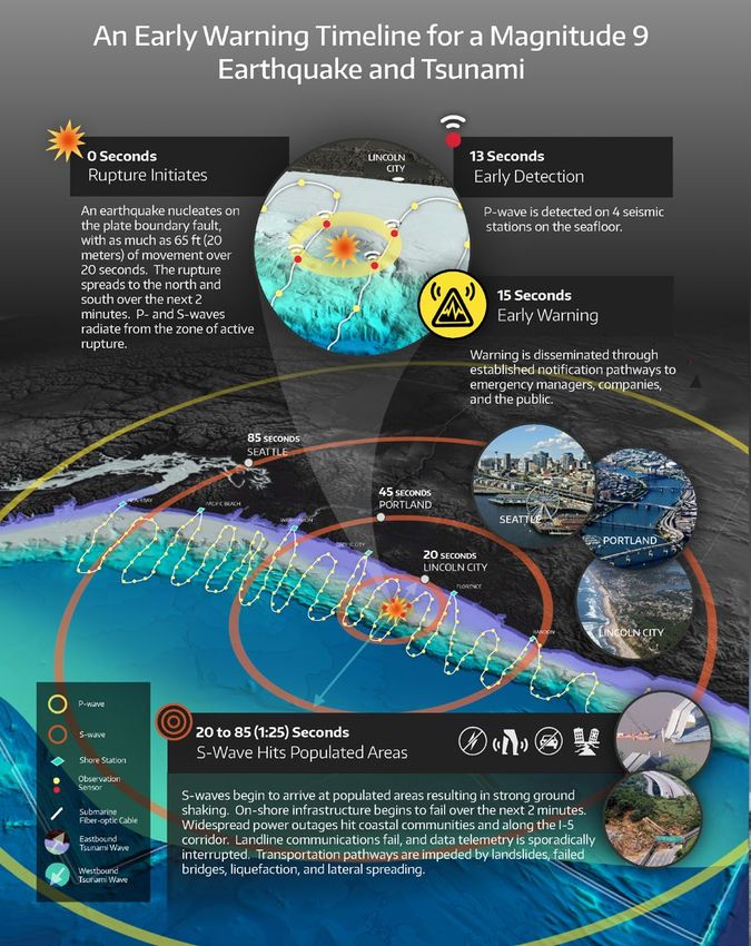
Offshore Earthquake and Tsunami Early Warning 9Figure 2. A timeline for earthquake and tsunami early warning that would be enabled by an offshore instrument network. The timeline
will vary for different locations depending on the epicenter of the earthquake (center star burst), here depicted offshore Oregon.
estimates. Direct observations of seafloor movement and sea surface height change would
provide immediate constraints on calculations to pinpoint a tsunami source, and help to
forecast the coastal wave height within the first 5–10 minutes after the earthquake, prior
to tsunami wave inundation along the closest coastline. The potential benefit of these
early warning systems is a significant reduction in deaths, injuries, and damage through
preemptive and automated mitigation actions.
Continuous, real time observations from an offshore instrument network would also
provide important seismological and geodetic data for the research community. Lacking
sustained observations, scientists are not certain what constitutes normal seismic behavior
on the Cascadia subduction zone; a long time series that includes normal seismic activity
is required to interpret precursory phenomena. Following the 2011 Tohoku Japan and 2014
Iquique Chile subduction zone earthquakes, post-event analysis revealed that undetected
transient fault slip was ongoing in the months prior to the earthquakes (Ruiz et al., 2014;
Kato et al., 2012). Had fault slip been detected, the data would have provided an indication
of unusual behavior along the faults prior to the large events. A similar strategy to monitor
precursory events is used now to predict volcanic eruptions well in advance. Real time
instrument networks located near the threat are key to the strategy. More research is
needed to evaluate whether precursory behavior near subduction zone faults is common,
and whether it may help indicate periods of heightened risk (Obara and Kato, 2016), but
an earthquake and tsunami monitoring network deployed offshore that was developed for
early warning purposes would also facilitate important research toward this goal.
10 Offshore Earthquake and Tsunami Early WarningOffshore Early Warning:
Motivations and Benefits
The Threat of Subduction Zone
Earthquakes and Tsunamis
Several recent events from around the globe have demonstrated the destructive power
of subduction zone earthquakes and tsunamis, and motivate the need to better equip
the population of the Pacific Northwest with an early warning system. Since 1960, more
than 254,000 tsunami deaths have occurred as a result of five large earthquakes with
magnitudes greater than 8.8 (Table 1). An additional 7,441 fatalities since 1960 were due to
eleven magnitude 8–8.7 events. The 2004 Indian Ocean Sumatra–Andaman magnitude 9.1
earthquake and tsunami collectively killed more than 225,000 people, and the 2011 Tohoku
Japan magnitude 9.1 earthquake and tsunami killed more than 20,000 people. Economic
damage associated with this scale of a compound natural disaster is often difficult to
quantify, but incorporates costs from extensive relief efforts, damage to infrastructure, and
severe impacts to important industries (e.g., fishing and tourism for Indonesia in 2004 and
the nuclear energy, automobile, and manufacturing industries for Japan in 2011). For both of
Table 1. Earthquakes of magnitude ≥ 8.8 and their societal impacts since 1960
Data from National Centers for Environmental Information (NCEI) / World Data Service (WDS), Global Historical Tsunami
Database, NOAA, doi:10.7289/V5PN93H7 and NCEI/WDS, Significant Earthquake Database, NOAA. doi:10.7289/V5TD9V7K
(both accessed April 8, 2019).
*Injury numbers are not divided between earthquakes and tsunamis.
**The databases do not distinguish deaths from the tsunami and earthquake. The NCEI has an information sheet on the
1960 Chile earthquake noting that deaths in Chile were estimated between 490 and 5,700 for the combined earthquake
and tsunami and that over 200 people died in Japan, Hawaii, and the Philippines due to the tsunami (May 22, 1960 Southern
Chile Earthquake and Tsunami, NGDC Information Sheet, Updated March 2015, NOAA, www.ngdc.noaa.gov/hazard/data/
publications/1960_0522.pdf).
Offshore Earthquake and Tsunami Early Warning 11the great earthquakes, damage estimates exceed many billions of dollars, and communities
are still recovering many years later.
The primary goal of a tsunami early warning system would be to save lives by giving
residents the maximum window of time to seek higher ground. For Cascadia, the resulting
tsunami will primarily affect residents who live along the outer coast, where the at-risk
population is estimated to be more than 43,000, swelling substantially during the summer
months, with an additional 21,000 in Northern California (Oregon Seismic Safety Policy
Advisory Commission, 2013). The number of fatalities is expected to be about 8,440 in
Washington (Washington Emergency Management Division, 2015), 1,300–10,000 in Oregon
(Oregon Seismic Safety Policy Advisory Commission, 2013), and 1,000 in Northern California
(FEMA, 2013). Communities along the inland Salish Sea are also at risk from a tsunami. But
of greatest concern are communities located on peninsulas facing the Pacific Ocean, such
as Ocean Shores, WA, where the time needed to evacuate by foot will exceed the time it
takes for the tsunami to reach the shore. In these circumstances, strategic siting of vertical
evacuation structures can reduce fatalities, but every second is critical to ensure life safety.
Tsunami forecasting is a more complex exercise than earthquake magnitude or location
calculations. Most tsunami warnings issued immediately after an earthquake are
provisional, because coastal impacts may depend heavily on spatial details of the coseismic
deformation and few near-source observations are available immediately. Examples of
this challenge are the 2011 Tohoku Japan and 2004 Indian Ocean Sumatra–Andaman
earthquakes, which produced tsunamis that were surprisingly large compared with
initial forecasts. Furthermore, many offshore earthquakes, including those as strong as
magnitude 8.0, do not produce a tsunami, particularly if the earthquake is located deep in
Earth’s crust. In contrast, the magnitude 7.5 2018 Sulawesi earthquake produced a large
tsunami with a maximum run-up of 35 feet above the regular sea level, killing an estimated
4340 (Marshall, 2019). This may be an example of a relatively small earthquake triggering a
submarine landslide on the continental slope where the sediments are unstable, thereby
resulting in a displacement of water and the formation of a tsunami (Heinrich et al., 2000).
The Sulawesi event may also be an example of a compound event (Heidarzadeh et al., 2019),
which complicates the correlation between felt ground motions and tsunami sources,
potentially making tsunamis more dangerous for unsuspecting coastal residents. Tsunamis
can also strike a coast with little or no strong ground shaking, as has been observed for
some slow earthquakes (Kanamori, 1972). Direct observations of seafloor or sea surface
movement from an offshore instrument network would provide the best information about
tsunami generation potential, and reduce the ambiguity when predicting the size of an
incoming tsunami.
Early Warning Systems
An early warning system is one that identifies disturbances in the natural world that are
likely to have a significant impact on society and provides useful alerts in anticipation of the
impacts, which can then lead to a response to mitigate the effects (Basher, 2006). These
alerts are triggered following the onset of an event, unlike a forecast that provides an
estimate or prediction of an event’s occurrence. For example, NOAA issues a tornado
watch to indicate when tornadoes are possible, whereas a tornado warning is issued
when a tornado has been sighted or detected on local radar. All warning systems share
basic components:
12 Offshore Earthquake and Tsunami Early Warning• Instruments to record a physical signal
• Low-latency data transmission pathways
• Algorithms to detect an event, to estimate the size and location, and to
generate alerts
• Pathways to distribute alerts rapidly to end-users
• An educated and informed set of users who know the proper response to
a warning, or automated systems that respond appropriately
Earthquake Early Warning
Earthquake early warning (EEW) systems rely on observing the characteristics of an
earthquake as close to the source (the rupturing fault) and as far from the asset (populated
area) to be alerted as possible. Most seismic systems rely on very brief measurements (a
few seconds at most) of the fast but weak early primary wave (P-wave) arrivals to determine
the size and location of a source. The P-wave information is used to forecast the arrival of
strong shaking from the more slowly propagating and more energetic secondary S-waves
and surface waves (Figure 3). Such systems usually use networks of instruments to detect
and locate the initiation of the event prior to the arrival of seismic waves at population
centers. The USGS ShakeAlert system is based on this detection strategy (Given et al.,
2018). Other seismic methods (e.g., Kuyuk et al., 2015; Kodera, 2018) use the pattern of
strong shaking observed closer to the source to forecast strong shaking arrivals at more
distant sites; this strategy is slower. Network methods may process data in real time at the
instrument location, and convert the observations to EEW parameters (amplitudes and/
Figure 3. The principles of earthquake early warning. (Image by Erin Burkett, USGS, and Jeff Goertzen, Orange County Register.)
Offshore Earthquake and Tsunami Early Warning 13Figure 4. Simulation of improved
earthquake warning times resulting from
the addition of offshore sensors. The white
contours indicate the additional seconds
of warning from an offshore earthquake,
when compared to a detection system using
only land-based instruments. The time
between the onset of an earthquake and
the time to detect P-waves on four stations
was first calculated as a function of location
using just the land-based stations (smaller
orange triangles). The calculation was then
repeated after the addition of six clusters of
offshore stations (larger red triangles) and
the reduction in detection time contoured
(white contours labelled in seconds).
Earthquake warning times for a subduction
zone earthquake (the locked region is
outlined by a dashed black line) improve
by up to 10–15 seconds for an earthquake
nucleating near the western updip limit of
the subduction zone.
or frequency content) or they may stream the complete
data package to a center where data processing and alert
production happen in near-real time.
Geodetic data — direct observations of the deformation
associated with the fault rupturing process (the ground
distortion) — are also used to identify the size and
location of an emerging earthquake in near-real time.
Geodetic EEW is most effective for large earthquakes
observed close to the source. Geodetic methods
include monitoring of monument positions using Global
Navigation Satellite Systems (GNSS) such as the Global
Positioning System (GPS). While geodetic methods are
generally slower than seismic methods, they are the
most certain to capture the full scale and slip distribution
when an earthquake’s magnitude exceeds a magnitude
7.5 threshold. The slight delay of geodetic estimates
compared to seismic methods is largely a consequence of
the observed phenomenon itself — it can take minutes for
a very large earthquake to grow to its full size. In this way,
seismic and geodetic data are complementary and independent inputs for a robust warning
of very large earthquakes. Real time geodetic methods are in the early stages of being
integrated into the ShakeAlert system (Murray et al., 2018).
EEW is used to notify people so that they may take mitigating actions — drop, cover, and
hold on, and be aware of nearby falling hazards — and to initiate automatic actions for
machine-controlled processes — slow trains, close or open valves, open elevator and fire
station doors. Mitigation actions depend on the intensity of shaking expected and the
warning time afforded. For a given earthquake, locations closer to the source will be shaken
with higher intensities than more distant sites, yet will receive shorter warnings.
14 Offshore Earthquake and Tsunami Early WarningThe alerts produced by an EEW system may be delivered by a host of technologies.
Generally, an alert center generates and sends an electronic message, which is then
provided to users through a low-latency delivery system. The messages themselves may be
brief electronic files that contain the location and size of the earthquake and its expected
shaking distribution. Receivers of these alerts can be technology enablers that use the
alerts automatically to take actions to prepare for, and protect from, incipient shaking.
Public alerts may be distributed by PA systems and/or sirens, by TV and radio broadcast
interrupts, and by cell phones or other personal communications devices, among others.
The ShakeAlert system will provide a warning for subduction zone earthquakes. The
timeliness and, perhaps, the reliability of the warning, however, would be improved
with offshore instrumentation. Instruments near the offshore epicenter would detect a
subduction zone earthquake earlier than coastal stations and are the only means to provide
a warning to coastal communities near the earthquake (Figure 4). Earthquake early warning
is most reliable for events that occur within the instrument network and thus, offshore
instruments may reduce the possibility of false alarms caused by detections of more distant
offshore earthquakes.
A Pacific Northwest Seismic Network Station
Tsunami Early Warning
Tsunamis are generated by the displacement of water. If the water surface is disturbed due
to seafloor motion, then gravity acts to redistribute the water to a new equilibrium. This is
accomplished by the initiation of a wave that propagates outward from the disturbance.
As the wave approaches a coastline, the wave is compressed and the height increases.
Local topographic features can also focus the wave, increasing inundation in some coastal
regions. Because of its long wavelength, a tsunami appears onshore as a flood that flows
inland for a great distance before receding. Earthquakes initiate this process by raising
or lowering the seafloor, and subduction zone megathrust earthquakes have created the
largest tsunamis in recorded history (Figure 5). Landslides can also produce tsunamis.
Offshore Earthquake and Tsunami Early Warning 15For tsunamis caused by earthquakes, tsunami early warning (TEW) systems typically
depend on an initial estimate of an earthquake source (location and size). Computer models
can then be used to estimate the deformation of the seafloor and the resulting perturbation
of the sea surface, predicting the inundation time and wave height along the coastlines. The
timeframe for TEW is different than EEW because the tsunami evolves and propagates over
minutes-to-hours before impacts are realized, whereas earthquake shaking is experienced
in seconds-to-minutes from the onset of the event. While TEW is a more complex operation
compared to EEW, there is more time to perform calculations and issue the alert.
Currently, most tsunami warnings in the U.S. and other countries use DART systems, which
were developed by the NOAA Pacific Marine Environmental Laboratory specifically for
real-time detection and transmission of tsunami measurements to NOAA Tsunami Warning
Centers in Alaska and Hawaii. The research and development effort was initiated in 1996,
and by 2003 operational responsibility was transferred to the NOAA Data Buoy Center for
the initial network of six DART systems off Alaska (three), Oregon (two), and near the equator
(one). The success and value of the network became evident when six potential false alarms
were avoided during 2000–2003 (González et al., 2005). Following the 2004 Indian Ocean
Sumatra–Andaman tsunami the network grew to 64 DART stations in the Atlantic, Pacific,
and Indian oceans, of which 39 are operated by the U.S. and 25 by partner countries.
Figure 5. The physical processes that generate a tsunami during a subduction zone earthquake. (Image from Atwater et al., 2005.)
Ocean bottom pressure instruments at sites distant from the tsunami source measure
changes in the hydrostatic pressure of the water column due to the increased surface
elevation as a long-wavelength tsunami passes; they are also affected by S-waves. These
data are used in real time to perform source inversion calculations and estimate the
tsunami accurately enough that more distant coastal regions can be warned. The source
inversion is accomplished by matching the DART observations to a linear combination of
tsunami wave forms that have been precomputed from numerical models (Gica et al., 2008;
Percival et al., 2011). This system provides tsunami warnings well in the Pacific Northwest for
far-field tsunamis originating in, for example, Japan, Alaska, or Chile (Figure 6).
For nearfield warning in Cascadia, data from the existing DART buoy network has limited
value. For example, a numerical model predicting the tsunami from a simulated magnitude
~9 earthquake that originates off the Oregon coast (Figure 7) shows that 15 minutes after
the earthquake, the tsunami is already striking some coastal regions, but has not yet
16 Offshore Earthquake and Tsunami Early Warningreached any of the three DART buoys in the Northeast Pacific. To provide nearfield warning,
NOAA is now considering the future installation of DART buoys directly west of the trench,
and thus closer to the source zone. One hour after the earthquake, the leading depression
(blue) wave caused by co-seismic subsidence is entering Puget Sound while the much larger
positive (red) tsunami wave is still traversing the Strait of Juan de Fuca, with an amplitude of
Figure 6. (left) A tsunami simulation of the 2011 Tohoku Japan tsunami 5 hours after the earthquake with color bar indicating displacement of the sea
surface, which is relatively small while the waves propagate in deep water. (right) Seafloor pressure time series recorded by DART instruments at sites
21413 and 52402 for 10 hours after the earthquake. Tsunami seismic and hydroacoustic waves arrive at these instruments within the first hour after the
earthquake, while the tsunami takes roughly 1.5 and 3.5 hours to reach these locations. The tsunami does not reach Hawaii or California until roughly 8
and 10 hours post-quake, respectively, giving ample time to issue warnings based on DART observations.
about 3 m (10 ft) in this simulation. At 2 hours post-quake, the tsunami is striking Whidbey
Island, the San Juan Islands, and the community of Port Townsend, WA. At 3 hours, a
diminished, but still potentially deadly, wave is apparent throughout Puget Sound, with
particularly large wave heights in Bellingham Bay and farther north in the Salish Sea (not
shown).
The simulation also shows that along the outer Pacific Coast there are large edge waves
with complex structure that propagate up and down the continental shelf for many hours,
with positive amplitude striking the vulnerable communities near Grays Harbor and Willapa
Bay at 3 hours post-quake (Figure 7). This hypothetical earthquake was chosen from a
set of 1300 simulations (Melgar et al., 2016). These simulated quakes and tsunamis yield
different wave patterns for events with the same magnitude, and different amplitudes and
arrival times (particularly for secondary waves) at each location. This variability is due largely
to differences in the deformation patterns of the ocean bottom and coastal regions for
different earthquake models and accentuates the need for better methodologies to assess
the detailed nature and potential impact of an actual earthquake in real time.
For nearfield warnings, the U.S. system now relies primarily on rapid point source seismic
inversion estimates of earthquake parameters including location, magnitude, and faulting
style. The median response time for the warning is around 8 minutes and it does not
include a forecast of the expected tsunami wave heights. Because the current system relies
mostly on regional seismic data, the seismic estimate is prone to magnitude saturation, in
which the system cannot distinguish between large and very large earthquakes. Thus, even
if a tsunami forecast were to be made it would likely underestimate the hazard. This was
the case during the 2011 Tohoku Japan earthquake, in which the initial warning severely
underestimated the hazard and was not updated until many hours after the earthquake.
Offshore Earthquake and Tsunami Early Warning 17Figure 7. The tsunami predicted by a numerical model for a hypothetical magnitude ~9 earthquake that originates off the
Oregon coast and ruptures bilaterally to the north and south over about 5 minutes. The initial seafloor deformation is –2.7
to +8.6 m. The red-blue color indicates elevation of the tsunami waves above or below sea level, respectively, and the colors
saturate at ±1-m elevation for clarity of the plots, although the tsunami generated is more than 10 m (33 ft) high when
striking parts of the coast. The top three frames show the tsunami 1, 3, and 15 minutes after the earthquake starts with the
location of three DART buoys in the region shown (dots in top row). The bottom three frames show a zoomed view of the
Washington coast, the Strait of Juan de Fuca, and Puget Sound at 1, 2, and 3 hours after the earthquake.
Efforts are now underway to incorporate geodetic observations from onshore GNSS
stations into the rapid source inversion process (Crowell et al., 2018a, b; Biffard et al., 2017).
A recent study reports that geodesy circumvents the magnitude saturation problem and
produces reliable estimates of earthquake source characteristics in the first 1–2 minutes
and a near-source tsunami warning within ~10 minutes (Melgar et al., 2016). Incorporating
this technology into the warning centers could lead to immediate improvements in nearfield
tsunami amplitude forecasting. Additional improvements in forecast ability for nearfield
hazards could be made by incorporating offshore observations. These efforts are already
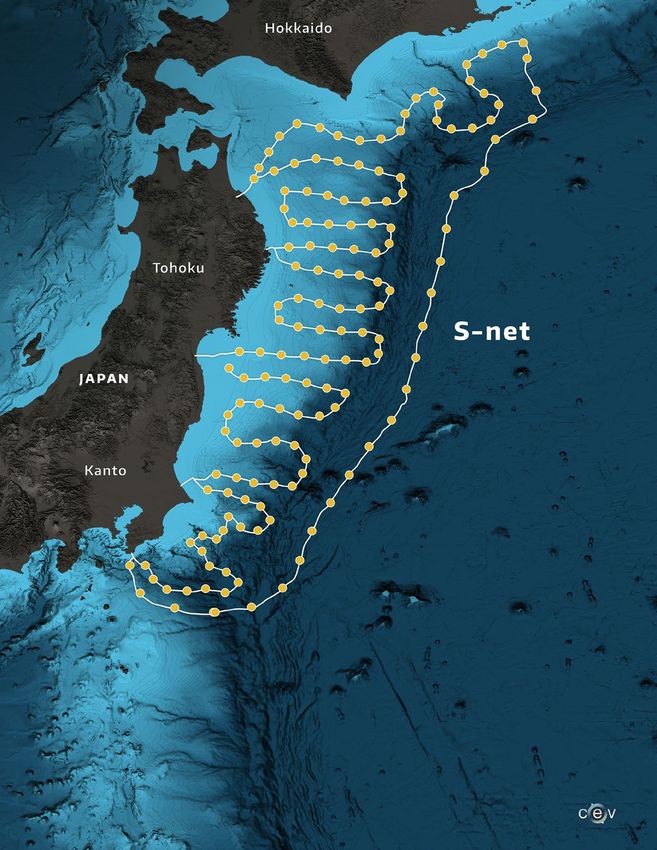
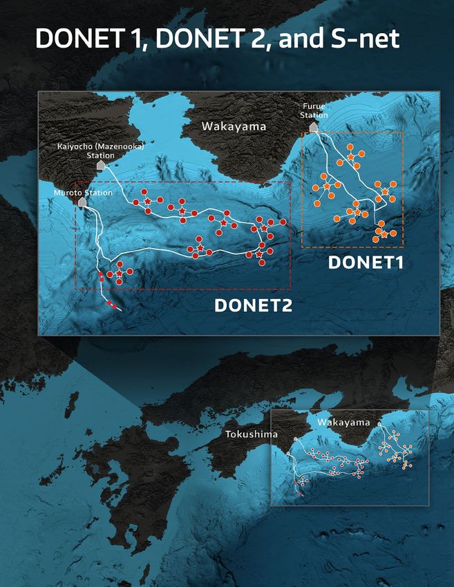
underway in Japan, using data from the Seafloor Observation Network for Earthquakes and
Tsunamis (S-Net; p. 44–45) and Dense Ocean Floor Network for Earthquakes and Tsunamis
(DONET; p. 44–45) cabled networks.
18 Offshore Earthquake and Tsunami Early WarningEarly Warning Systems Using
Offshore Observations
An effective earthquake and tsunami early warning system must answer the following
questions:
• Has an event happened?
• How large is the event?
• Where is the event?
• How long until ground shaking/tsunami waves reach populated areas?
• How intense will ground shaking/tsunami waves be?
• When is it safe to return to coastal regions?
Developing a framework for answering these questions, and designing warning and
response activities is the focus of existing earthquake and tsunami early warning
protocols (Given et al., 2018); research and development efforts are underway to design
observation-based algorithms to provide warnings. There are specific observations needed
for EEW, TEW, and rapid modeling of events (Table 2). Some of these observations are
similar for onshore and offshore environments, but some cannot be made without offshore
instruments. For either case, offshore observations would make warnings faster and
more accurate.
If a magnitude 9 earthquake on the Cascadia subduction zone occurred, how would an
EEW and TEW system work? Paleoseismic studies (Goldfinger et al., 2012; Witter et al.,
2013) report that large megathrust earthquakes, many extending along the entire Cascadia
margin, have occurred repeatedly, most recently in 1700 (Atwater et al., 2015; Satake et al.,
2003). Such an event is a reasonable and even likely scenario of a future Pacific Northwest
great earthquake. Considering an earthquake and tsunami scenario based on a magnitude
9, full-margin rupture, key parameters such as the north–south (along-strike) and east–west
(down-dip) rupture extent, the amount of seafloor uplift, and maximum amount of slip along
the fault have important effects on the size of resulting tsunami waves, on the amount of
strong ground shaking experienced along the West Coast, and on the propagation time of
surface waves and tsunami waves that are expected to impact the region.
Table 2. Observations required for early warning
Offshore Earthquake and Tsunami Early Warning 19The scenario illustrated here (p. 20–21) uses a hypothetical source hypocenter (the initiation
point of the earthquake rupture) approximately 40 miles offshore Lincoln City, Oregon;
the location of the hypocenter influences the time by which communities begin to
experience earthquake effects and tsunami waves. The scenario also specifies the amount
of seafloor deformation, based on recent research of possible earthquake events (Witter et
al., 2011, 2013).
20 Offshore Earthquake and Tsunami Early WarningThe key milestones of the hypothetical scenario are the initiation of the earthquake, the
measurement of shaking by an instrument network, the detection of the incipient event
and the generation of a warning (application of well-developed early warning algorithms),
the transmission of the warning to population centers, and the onset of local impacts in the
form of strong ground shaking and water inundation along the coastline. Rupture along the
fault during a magnitude 9 earthquake would develop over 3–5 minutes, perhaps longer.
Offshore Earthquake and Tsunami Early Warning 21Offshore observations would make earthquake
and tsunami warnings faster and more accurate.
Promptly after rupture initiation, warning system elements would start reacting: ~10–15
seconds after the initiation of an event of any size, seismic stations would have observed
the fastest P-waves, and an alarm would be issued. Soon thereafter, and well before the
earthquake process has completed, strong ground motions would be felt at the closest
communities such as Lincoln City (~20 s after initiation), Salem (~40 s), Portland (~45 s), and
Seattle (~85 s). The destructive impacts to infrastructure begin as soon as these ground
motions begin. The EEW would also trigger the tsunami modeling algorithms and seed initial
modeling parameters.
As the event continues to grow in magnitude, the seafloor displacement would begin
generating tsunami waves, the largest of which would be sourced near the region of the
largest shallow fault slip, again offshore Lincoln City, and potentially extending in a north–
south extent along most of the margin. As soon as seafloor displacement occurs, seafloor
geodetic instrumentation would be used to characterize the source of the tsunami, refine
the ongoing modeling, and produce a detailed tsunami forecast. Models and inundation
maps driven and generated by data from offshore instruments should be capable of
producing a detailed warning well before tsunami waves reach the Oregon coastline,
about 10–15 minutes after the initiation of fault slip. Refinement of warnings, earthquake
source estimates, and tsunami source models would continue as more data were collected
from onshore and offshore instruments, and as the rupture continues to evolve. Tsunami
forecasts would continue to be updated for several hours after the earthquake to determine
when it is safe to return to coastal areas.
Coastal residents expect that any local large tsunami will be preceded by strong ground
shaking, but this is not always the case. Subduction zones like Cascadia, such as the Chile,
Central America, Sumatra, and Alaska margins have generated tsunamis that were not
accompanied by the ground shaking associated with a magnitude 8–9 earthquake. These
present a special challenge to existing tsunami warning systems. ‘Tsunami earthquakes’
have been documented at subduction zones globally (Ammon et al., 2006; Kanamori, 1972;
Kanamori and Kikuchi, 1993; Lay et al., 2007) and are usually characterized as an earthquake
that occurs near the updip extent of a plate boundary fault, usually far offshore and with a
slow rupture relative to that of a typical earthquake. These events generate a large tsunami
relative to the magnitude of the earthquake. One recent example is the magnitude 7.8
2010 Mentawai earthquake, which ruptured the shallow portion of the subduction zone
off Sumatra and generated a run-up that was much larger than anticipated by locals who
felt the earthquake; 431 lives were lost (Lay et al., 2011). A relatively small earthquake can
also trigger a large slope instability (Heinrich et al., 2000), or a slope instability can occur
with no earthquake at all (Schiermeier, 2017). Here, displacement of material along the
seafloor creates a large tsunami wave without any ground shaking felt at the coastline. These
scenarios, in which there is little or no earthquake shaking experienced on land, would
make seafloor instrumentation essential for sensing the initiation of a large tsunami. For a
slow earthquake rupture or submarine landslide source, the initial EEW sequence may be
less important than the integration of direct seafloor displacement and sea surface height
measurements into an offshore tsunami warning system. Because little or no ground shaking
22 Offshore Earthquake and Tsunami Early Warningwould be felt by people on land, they would have even less awareness that a tsunami is
imminent in these scenarios (p. 24–25).
The scenarios described here and other models provide a tool to evaluate the relative
timelines of the source process, seafloor and land-based observational goals, analysis goals,
and impacts. They also can be used to prioritize specific system elements. Extending a
seismic monitoring network offshore reduces the time needed to detect the arrival of initial
P-waves by several seconds, adding this amount of time to the total earthquake warning time
for both the closest and more distant communities. The capability to quantify the seafloor
deformation patterns in real time using a seafloor instrument network could identify the
onset of a tsunami, reduce the time needed to conduct accurate tsunami modeling, and
provide several additional minutes of accurate tsunami impact estimates to guide warnings
and emergency responses (LeVeque et al., 2018). Currently, without geodetic information
offshore, tsunami modeling begins when an earthquake source is determined from far-field
seismic stations, after the earthquake rupture process has completed (~ 5 minutes). Tsunami
models driven by the far-field seismic stations produce less accurate forecasts of anticipated
impacts such as run-up heights, which are critical to the nearfield coastal communities.
Early Warning Saves Lives
and Reduces Damage
It is widely accepted that early warning systems save lives (UNISDR, 2010). A relatively well-
established example of successful warning systems are cyclone warning systems, which
provide longer warning times (days as compared to minutes), but also require much greater
evacuation distances. The Hong Kong Tropical Cyclone Warning System has dramatically
reduced the number of deaths and missing persons since 1960 (Rogers and Tsirkunov, 2010).
Cyclone deaths in Bangladesh have also decreased dramatically since 1970, due in part to the
Bangladesh early warning system (Haque et al., 2012).
Motivated by the clear benefits, EEW systems have already been implemented in several
countries worldwide, including Mexico, Japan, Turkey, Romania, China, Italy, and Taiwan. Both
Mexico and Japan operate systems that disseminate widespread warnings to the public
and the lessons learned from these systems (Allen et al., 2012) are helping to guide similar
implementations in several other countries, including the U.S., where the ShakeAlert system
is being developed for the West Coast. The best demonstration of the effectiveness of an
EEW system is the 2011 Tohoku Japan earthquake. Here, the Japanese EEW system provided
several million people with 15–20 s of warning prior to the most severe shaking, with 90%
reporting that they took actions to protect themselves or their family from injury (Fujinawa
and Noda, 2013). Studies of the casualties from the Tohoku Japan tsunami show that an
earlier evacuation start time was an important predictor of survival (Yun and Hamada, 2015).
Japan is now in the process of developing the world’s first nearshore tsunami warning system
using local offshore observations to improve the quality and timeliness of warnings.
The benefits of early warning in the Pacific Northwest are reduced damage to infrastructure
and its impacts, and fewer fatalities and injuries. The economic benefits of early warning
are likely substantial, although they are difficult to estimate and more detailed studies
are needed. Direct and indirect economic losses for a subduction zone earthquake have
been predicted to be approximately $49 billion in Washington, $32 billion in Oregon
(Cascadia Region Earthquake Workgroup, 2013), and CAN$75 billion for British Columbia
(AIR Worldwide, 2013). For comparison, estimates of the actual losses for the 2011 Tohoku
Offshore Earthquake and Tsunami Early Warning 23SCENARIO RESPONSE/ACTIONS
A
Large Magnitude Earthquake TRAINS &
(Major shallow fault slip—extreme shaking) ELEVATORS
OREGON INITIATE
WASHINGTON
COAST
SHUTOFF
PROCEDURES
GAS/ELECTRIC IMPROVED
EMERGENCY
RESPONSE
TSUNAMI TRIGGERED
DROP! COVER! HOLD ON!
B
Tsunami Earthquake 15 SECONDS OF EARTHQUAKE EARLY WARNING
(Slow rupture and less-severe ground shaking
on the coast) OREGON
WASHINGTON
COAST
0 1 2 3 4 5 6 7 8 9 10 11 12 13 14 15
EARTH
QUAKE (SECONDS)
TED
DETEC
G IN
SHAKIN
0:15DS
SECON
TSUNAMI TRIGGERED
A EXTREME SHAKING
B MILD SHAKING
C Submarine Landslide on the
C NO SHAKING
Continental Slope
(No shaking)
0 1 2 3 4 5 6
Tsunami Warning…
But there’s NO shaking?
?!?
?!
?!?
?!?
24 Offshore Earthquake and Tsunami Early Warning
TSUNAMI TRIGGEREDTSUNAMI EARTHQUAKE &
SUBMARINE LANDSLIDE EVENT
There are three possible scenarios that can lead to a tsunami: (A) a large magnitude earthquake that
distorts the seafloor (see page 18 for the magnitude 9 scenario), (B) a tsunami earthquake (or sometimes
called a slow earthquake) that distorts the seafloor, and produces a tsunami that is larger than expected
relative to the magnitude of the earthquake, or (C) a submarine landslide that displaces seawater and
initiates a tsunami. For these three scenarios, residents on the coast would experience dramatically
different levels of ground shaking prior to the arrival of the tsunami, ranging from intense shaking from a
large earthquake, to mild shaking from a tsunami earthquake, to no shaking for the submarine landslide.
The violent shaking of a large offshore earthquake would forewarn the coastal population of a possible
tsunami. But the population may be caught by surprise when a tsunami arrives with little or
no ground shaking. An offshore geophysical instrument network would provide direct
information about an offshore tsunami, and could initiate a tsunami early warning for all three
scenarios. An early warning would alert the coastal populations, instigate a response to seek
high ground, and activate emergency response plans. REFUGE
VES GET TO VERTICAL
EVACUATION
STRUCTURES
GET TO
HIGHER
GROUND
7 8 9 10 11 12 13 14 15 16 17 18 19 20
(MINUTES)
MI
TSUNA
IN G
WA R N
15 MINUTES OF TSUNAMI EARLY WARNING
ES IN
ARRIV
15:00 ES
MINUT
PREDICT WAVE IMPROVE EMERGENCY PROVIDE CONTINUAL
HEIGHT/INUNDATION FIRST RESPONDERS UPDATED FORECASTS
Offshore Earthquake and Tsunami Early Warning 25
RESPONSE/ACTIONSearthquake range from $220 billion (Table 1) to over $300 billion (Daniell et al., 2011).
Much of the direct damage from an earthquake and tsunami cannot be avoided by early
warning but there are some significant exceptions. For example, EEW can be used to shut
down gas lines to minimize fires, secure delicate manufacturing and data systems, and
protect transportation infrastructure by slowing down trains and securing airports (Strauss
and Allen, 2016). The indirect economic benefits from early warning are likely to be more
widespread because if society is more resilient, economic activity can resume more quickly.
The Multihazard Mitigation Council has found that, on average, every $1 spent on mitigation
of natural disasters provides $4–$6 in cost reduction (Multihazard Mitigation Council, 2017).
The benefits of fewer casualties gained with early warning are easier to estimate. For
example, based on the nature of casualties following the magnitude 6.9 1989 Loma Prieta
and magnitude 6.7 1994 Northridge California earthquakes (Shoaf et al., 1998), EEW might
be expected to reduce injuries by over 50% for a population that is well trained about
effective responses. For the Northridge earthquake the estimated cost of injuries was $1.8–
2.9 billion (Porter et al., 2006), so EEW might have translated into savings of $1–1.5 billion
(Strauss and Allen, 2016). A TEW system would save lives by giving individuals the maximum
amount of time to evacuate the inundation zone. Given FEMA’s value of $6.3 million per
life and anticipated fatalities of 16,000 along the coast, the potential human cost from a
Cascadia subduction zone tsunami is near $100 billion. Even with only a small reduction in
injuries and fatalities, an earthquake and tsunami early warning system would pay for itself
and other preparedness planning.
Without a warning system in place, strong shaking along the coast would likely be the only
advanced warning that a large tsunami is expected. Planning and education is essential to
ensure that people know to move as quickly as possible to high ground, as far above sea
level as possible. However, there are several reasons why it is also desirable to develop
more effective methods for providing nearfield earthquake and tsunami warnings.
Improved earthquake warnings that allow people along the coast time to drop, cover, and
hold on before the worst shaking starts, or potentially leave an unsafe building or stop
dangerous activities, would reduce injuries, and increase the number of people who would
then be able to move quickly out of the inundation zone or access vertical evacuation
structures once the shaking stops. Moreover, although the first wave will arrive at coastal
locations near the earthquake source region very quickly, tsunami wave inundation often
continues for many hours after the first wave has arrived. An improved TEW system would
provide more detailed information about the wave heights, expected arrival times, and later
arriving waves than is available from the current warning system. Along with more timely
warnings to the public, this would aid first responders and provide better data to guide
decision making by emergency managers.
Although the correlation between earthquake ground shaking and a potential imminent
tsunami is becoming more recognized by the general public, this type of warning will not
exist for all scenarios, as some events and locations will not necessarily be associated with
strong shaking. The advantages of creating a TEW system are especially clear for coastal
communities in the Salish Sea (including Puget Sound). These communities will experience
the first wave more than two hours after the earthquake due to the relatively slow
propagation through the Strait of Juan de Fuca. In scenarios where tsunamis are triggered
by an earthquake concentrated on the southern edge of the Cascadia subduction zone
from a ‘tsunami earthquake’ that has relatively little shaking, or by a submarine landslide
event that is aseismic, a better nearfield tsunami warning system could provide the only
warning for these communities that a tsunami is imminent, as well as valuable information
regarding the time, size, and severity of a coming event.
26 Offshore Earthquake and Tsunami Early WarningYou can also read