ST THOMAS' CHURCH PARK LANE, Liverpool
←
→
Page content transcription
If your browser does not render page correctly, please read the page content below
ST THOMAS’
            CHURCH
            PARK LANE,
Liverpool
            Liverpool

            Archaeological
            Watching Brief Report

             Oxford Archaeology North

             Grosvenor

             July 2010

             Issue No: 2010-11/1078
             OA North Job No: L10203
             NGR: SJ 3455 8982
St Thomas’ Churchyard, Park Lane, Liverpool: Archaeological Watching Brief                                                     1

                                                      CONTENTS

ACKNOWLEDGEMENTS ................................................................................................... 3

SUMMARY ....................................................................................................................... 4

1. INTRODUCTION ........................................................................................................... 5
   1.1 Contract Background ...........................................................................................5

2. METHODOLOGY .......................................................................................................... 6
   2.1 Project Design .....................................................................................................6
   2.2 The Watching Brief..............................................................................................6
   2.3 Biographical Research .........................................................................................6
   2.4 The Archive.........................................................................................................7

3. BACKGROUND ............................................................................................................. 9
   3.1 The Site ...............................................................................................................9
   3.2 Brief History of St Thomas Church......................................................................9

4. BRIEF HISTORY OF SELECTED PERSONS INTERRED WITHIN THE GRAVEYARD ........ 13
   4.1 Introduction .......................................................................................................13
   4.2 Tate / Williamson ..............................................................................................13
   4.3 Fuhrer ................................................................................................................16
   4.4 Prince ................................................................................................................16
   4.5 Bushell...............................................................................................................17
   4.6 Pownall..............................................................................................................18
   4.7 Lake...................................................................................................................19
   4.8 Cross .................................................................................................................19
   4.9 Corlett ...............................................................................................................20
   4.10 Lewis.................................................................................................................20
   4.11 Ridings ..............................................................................................................20
   4.12 Hamer................................................................................................................21
   4.13 Hutchinson ........................................................................................................21
   4.14 Douglas .............................................................................................................22
   4.15 Blackburne.........................................................................................................23
   4.16 Watkinson..........................................................................................................23
   4.17 Roughsedge .......................................................................................................25
   4.18 Openshaw ..........................................................................................................26
   4.19 Kent...................................................................................................................27
   4.20 Stewart / McNeill...............................................................................................27
   4.21 Wainwright........................................................................................................28
   4.22 Price / Southworker / King.................................................................................28
   4.23 Abbott ...............................................................................................................29
   4.24 Foreshaw ...........................................................................................................29
   4.25 Boulton / Twist/ Wrights....................................................................................29
   4.26 Richardson.........................................................................................................30
   4.27 Rathbone ...........................................................................................................30
   4.28 Bourne...............................................................................................................31
   4.29 Currie ................................................................................................................31

For the use of: Grosvenor                                                                                 ©   OA North July 2010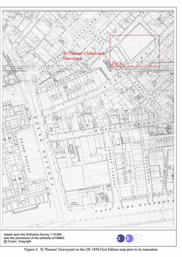
St Thomas’ Churchyard, Park Lane, Liverpool: Archaeological Watching Brief                                                    2

   4.30 Swarbrick ..........................................................................................................32
   4.31 Fearnley / Feaviour ............................................................................................32
   4.32 Haigh.................................................................................................................33
   4.33 Brown................................................................................................................33
   4.34 Goore / Staniforth ..............................................................................................34
   4.35 Shaw..................................................................................................................36
   4.36 Leather ..............................................................................................................37
   4.37 Molyneux ..........................................................................................................37

5. WATCHING BRIEF............................................................................................... 38
   5.1 Introduction .......................................................................................................38
   5.2 Fieldwork Results ..............................................................................................39
   5.3 Finds..................................................................................................................42

6. CONCLUSIONS .......................................................................................................... 44

7. BIBLIOGRAPHY ........................................................................................................ 45

APPENDIX 1 - PROJECT DESIGN .................................................................................... 47

APPENDIX 2 - CONTEXT LIST ....................................................................................... 52

ILLUSTRATIONS ............................................................................................................ 53

For the use of: Grosvenor                                                                                ©   OA North July 2010
St Thomas’ Churchyard, Park Lane, Liverpool: Archaeological Watching Brief                    3

                               ACKNOWLEDGEMENTS

OA North would like to thank Grosvenor for initiating the work and assistance in the course
of the project. In particular, we would like to thank David Parsons and Rod Holmes of
Grosvenor for setting up the project and Mark Ellison and James Alderson, for their
continued support during the secondary phase of the investigation. In addition, we would
like to thank the staff of Willerbys Landscaping, including Paul White, for their assistance
throughout. We would also like to thank Mark Adams (Diocesan Archaeologist) and Sarah
Jane Farr (Merseyside Archaeologist) for their help and support in setting up the project.
We would also like to thank the Friends of Williamson’s Tunnels who provided considerable
support, enthusiasm, and a wealth of documentary information. In particular, we are grateful
to the following: Claire Moorhead, Frank Hodges, Don Higham (who undertook much of
documentary work for the 2005 investigation), Bill Douglas, Les Coe, Steve Moran and Jeff
Jones. Thanks are also due to Gabriel Muies, of the Joseph Williamson Society, for his
support.
The field work was undertaken by Rik Buckle, Tim Christian, Dana Campbell, John
Griffiths, Jamie Quartermaine and Caroline Raynor. The report was compiled by Caroline
Raynor and Dana Campbell, who also undertook the survey; the drawings were produced by
Anne Stewardson. The project was managed by Jamie Quartermaine, who also edited the
report.

For the use of: Grosvenor                                                    ©   OA North July 2010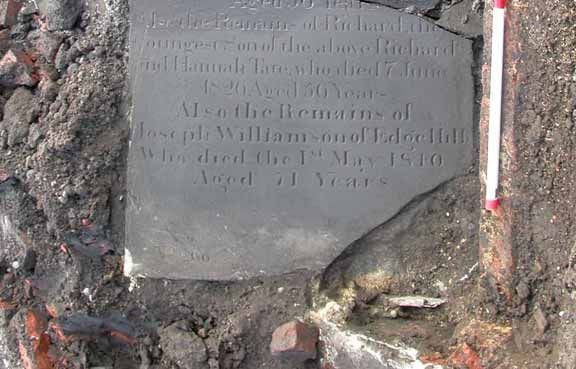
St Thomas’ Churchyard, Park Lane, Liverpool: Archaeological Watching Brief                    4

                                           SUMMARY

In October 2009 and January 2010 Oxford Archaeology North (OA North) undertook a
watching brief on Site LA6A of the Paradise Street Development Area (PSDA) project
located in Liverpool city centre (SJ 3455 8982), on behalf of Grosvenor. Site LA6A is a
triangular area located between the southern end of Paradise Street and Park Lane and was
formerly the site of St Thomas’s Church and graveyard.
The site was being developed as an area of urban park, requiring landscaping. The graveyard
has never been deconsecrated and any below ground impact required a faculty from the
Diocese of Liverpool to enable ground works to proceed. In order to facilitate this, and to
ensure that there was limited impact to the graves which were less than 0.5m below the
surface, the design of the park provided for minimal below ground impact. The landscaping
works included the remodelling of the area with the addition of a retaining wall, tree pits and
seating area to create St Thomas’ Memorial Garden. Despite this, there was some anticipated
invasive impact, requiring a watching brief. The watching brief was undertaken in
accordance a project design compiled by OA North (Appendix 1), and was approved by the
Diocesan Archaeologist. This followed on from an earlier watching brief, during which
numerous grave stones and grave plots were uncovered in the north-western part of the site
(OA North 2005), and was required to establish the survival of graves and the location of
that of Joseph Williamson. The intention during this secondary phase of investigation was to
provide a mitigative record of any extant remains uncovered as a result of the landscaping
process.
The proposed garden was located within the walled sandstone boundaries of the original
churchyard as seen on the 1850 and 1893 Ordnance Survey maps. The only surviving
element of the boundary wall is the original north/south wall, which is parallel with the
present Park Lane. During the present watching brief further grave stones were exposed, as
was a small section of church wall. The slabs have been recorded and individually
photographed, the locations of the majority of the graves were planned and detailed records
were made for each.
A programme of biographical research was undertaken to present a picture of selected
individuals within the graveyard who have contributed significantly to the development of
Liverpool and who were important members of Liverpool Society. This was intended to
inform a proposed information panel that is to be erected within the Memorial Garden. St
Thomas’Church was at the centre of Liverpool in the eighteenth century; many of the more
influential and wealthy citizens of Liverpool lived or worked in its environs and a significant
number were interred within its graveyard. The research examined only a small number of
the interred individuals and these were scattered throughout the former graveyard, not just
within the extent of the proposed Memorial Garden.

.

For the use of: Grosvenor                                                    ©   OA North July 2010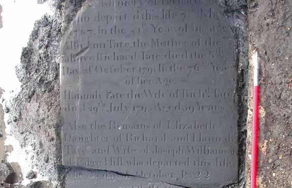
St Thomas’ Churchyard, Park Lane, Liverpool: Archaeological Watching Brief 5
1. INTRODUCTION
1.1 CONTRACT BACKGROUND
1.1.1 A watching brief was undertaken by Oxford Archaeology North (OA North) at the
site of the former St Thomas’ Church graveyard, which is at the intersection of Park
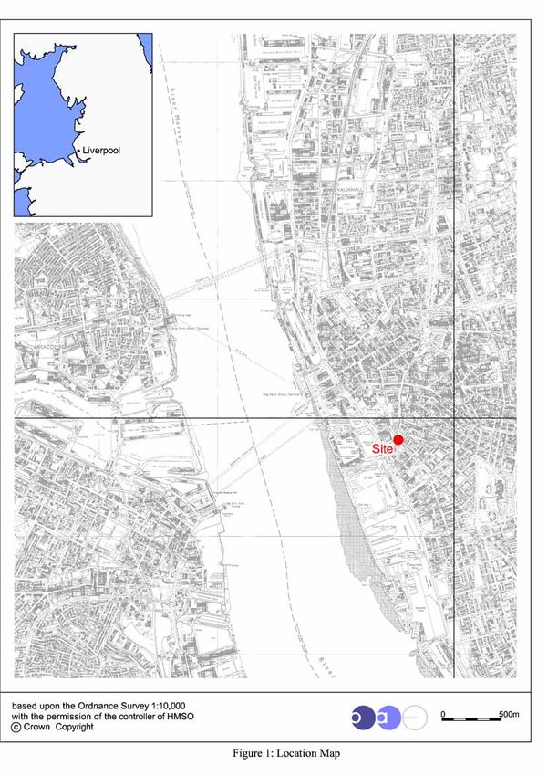
Lane and Paradise Street in Liverpool City Centre (SJ 3455 8982) (Fig 1). The work
was undertaken on behalf of Grosvenor and entailed the observation of landscaping
works for the construction of a Memorial Garden, dedicated to those still buried on
the site.
1.1.2 The proposed landscaping by Grosvenor was designed to have a minimal impact
upon the underlying remains, and so as to afford protection for the graves, the level
of the ground was raised using imported soil. It was anticipated, however, that there
would be some localised disturbance into the present ground surface. The design
element that had the greatest impact both in the short and long term was the planting
of trees, as there needed to be an allowance for the root bowl.
1.1.3 The church yard is still consecrated, even though St Thomas’ Church was closed in
1905 (Fig 2). As such, any development to the site is subject to a faculty from the
Diocese of Liverpool. Work is required as part of a programme of works across the
PSDA site and in line with a guidance document issued by The Church of England
and English Heritage, which sets out best practice and outlines specific
considerations: ‘Guidance for best practice for treatment of human remains excavated
from Christian burial grounds in England’ (2005). The maintenance of an
archaeological watching brief during the intrusive ground works to the site was a
planning requirement and subject to Diocesan Advisory Committee (DAC) Faculty.
1.1.4 The site had previously been investigated by OA North (2005) which revealed that
the grave slabs were, for the most part, intact and in situ, although there were some
relocated from part of the site that had been disturbed by the construction of the
adjacent south-eastern extension of Paradise Street. The previous watching brief also
discovered the disturbed slab marking the burial vault in which Joseph Williamson,
the Mole of Edge Hill, had been interred.
1.1.5 The Phase 2 watching brief took place intermittently between the 4th of November
2009 and the 9th of February 2010 as the nature of the work meant that no permanent
presence was required.
1.1.6 In addition to the watching brief, documentary research was undertaken about
selected individuals interred within the graveyard so as to inform a proposed
information panel to be erected on the site. The summary results of that research are
presented within this report (Chapter 4).
For the use of: Grosvenor © OA North July 2010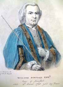
St Thomas’ Churchyard, Park Lane, Liverpool: Archaeological Watching Brief 6
2. METHODOLOGY
2.1 PROJECT DESIGN
2.1.1 A project design was submitted by OA North in September 2009 (Appendix 1) in
accordance with a verbal brief by the Diocesan archaeologist. The project design
provided for an archaeological watching brief and options for excavation and exposure
of any burial slabs. The work undertaken followed the method statement detailed in the
project design (Appendix 1) and complied with current legislation and accepted best
practice, including the Code of Conduct and the relevant professional standards of the
Institute of Field Archaeologists (IFA).
2.1.2 Following acceptance of the project design, OA North undertook the watching brief of
the service trench in December 2009 and January 2010.
2.2 THE WATCHING BRIEF
2.2.1 The watching brief entailed the monitoring of the excavation of shallow foundation
trenches for a retaining wall to the required formation level of c500-800mm, and small
discrete trenches for the installation of tree pits and foundation pads for a bench at the
north-east corner of the site. The excavations was undertaken using a two ton tracked
excavator, with a 1m ditching bucket, and a pneumatic breaker used to remove
concrete, hardcore and overburden deposits. Where possible the design solution for the
proposed garden limited the interference of extant archaeological features relating to
both the church and burials and, consequently, the watching brief for the most part
exposed only the grave slabs.
2.2.2 Recording: the recording comprised a full description and preliminary classification of
features, horizons or structures revealed, on OA North pro-forma sheets, and their
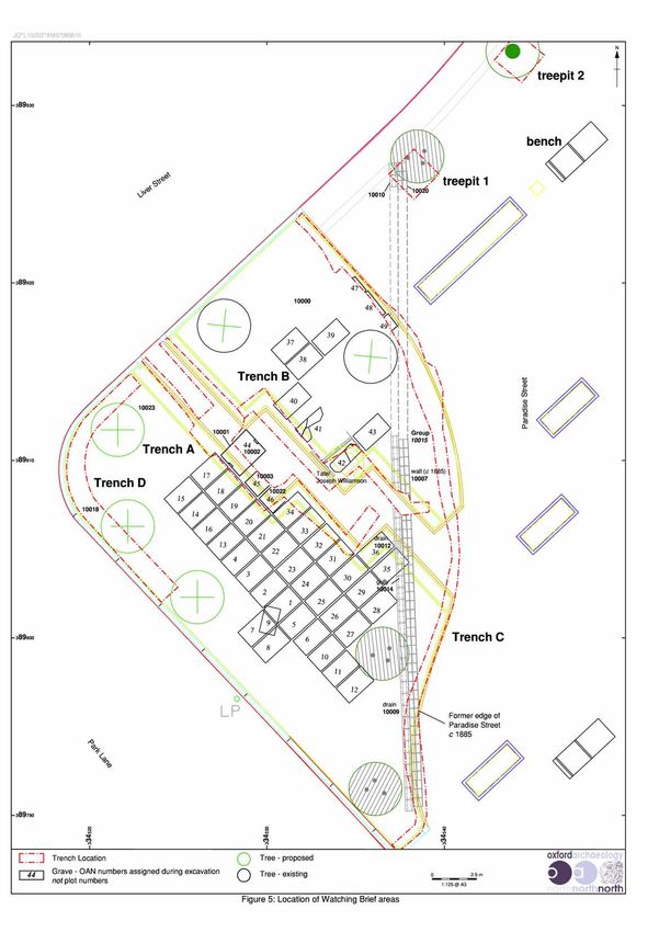
accurate location in plan (Fig 5), which was tied into the National Grid. A
photographic record in both colour slide and monochrome formats was also produced.
2.2.3 All horizons exposed were examined within the excavated areas, with all
archaeological features, horizons and any artefacts found during the excavation,
recorded as appropriate. The excavation of any human remains, had it been necessary,
was to be undertaken by an osteologist for immediate reburial following appropriate
analysis; however, in the event no articulated remains were exposed.
2.3 BIOGRAPHICAL RESEARCH
2.3.1 A programme of biographical research was undertaken to present a picture of selected
individuals within the graveyard who have contributed significantly to the
development of Liverpool and who were important members of Liverpool Society. It is
difficult to provide a clear overview of the cross section of individuals buried within St
Thomas’ Graveyard because only a small portion of it has been thoroughly excavated
and recorded and there are limited surviving records detailing the burial inscriptions
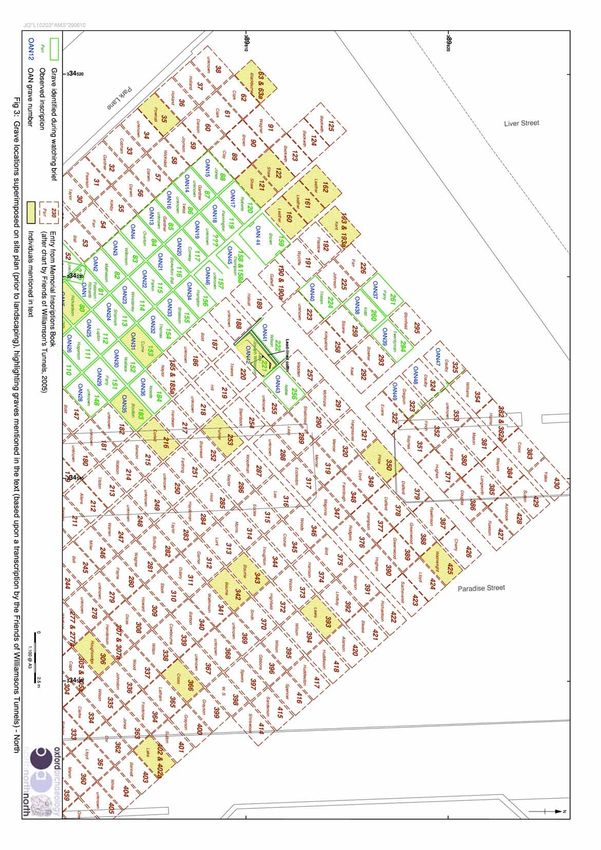
(Figs 3-4).
2.3.2 The Liverpool Records Office holds a microfiche of an anonymous document
produced c1906 prior to the church being demolished (LRO/Hf352 CEM 1/17/2), and
provides a simple record of the inscriptions of some of the grave stones that survived
For the use of: Grosvenor © OA North July 2010St Thomas’ Churchyard, Park Lane, Liverpool: Archaeological Watching Brief 7
in the graveyard after 1885 (LRO/Hf352 CEM 1/17/1). It is unclear if the document
was originally more extensive or if the person who produced the record chose only to
record a small random sample of the existing inscriptions, perhaps based on those
which were most legible at the time. The anonymous document provides us with 39
family names and associated inscriptions. Exploratory work by OA North between
2005 and the present day have added to this with the identification of a further 49
grave stones, helping to confirm the accuracy of the Memorials Inscription book
lodged at the Liverpool Record Office. This gives a total of 88 out of the original 445
burials (20%) which have been recorded. An earlier burial plot proposal from 1765
(CH/TCBP) (Plate 9) details the layout of the burial layout, but the plot numbers do
not match those of the later burial plan (LRO/Hf352 CEM 1/17/2) and does not record
the identity of the incumbents.
2.3.3 The overall size of the graveyard indicates that it would probably have been able to
accommodate approximately 532 standard brick shaft graves. It is not clear, however,
whether all of these plots were ever occupied. If each grave was occupied to capacity
with six individuals then the graveyard would have had the capacity to contain 3192
individuals. This represents over half of the people recorded as living within the Parish
of St Thomas at the height of the Parish’s expansion in the nineteenth century before
numbers started to dwindle leading to the closure of the church.
2.3.4 The Memorial Inscriptions book at the Liverpool Records Office provides family
names for approximately 445 plots, suggesting that 85% of the graveyard was
occupied, or at least purchased with the intention of occupation. Following the
extension of Paradise Street in 1885, approximately 222 graves (roughly 50% of the
graves and a maximum of 1332 burials) were moved to make way for the new road.
2.3.5 Because the church was built by subscription and because of the nature of the graves
(standard rectangular brick shaft graves), it was predominantly wealthy individuals
who could afford to purchase a family plot, and who were interred within the
graveyard. Despite this perceptible class barrier, a number of individuals were mindful
enough to purchase plots for their servants.
2.3.6 Due to the limited nature of the excavation work carried out, it has not been possible to
provide a complete overview of the social demographic of persons interred within the
graveyard of St Thomas, as the brief was to provide an overview of selected
individuals. It is likely that a further period of research could produce further in-depth
biographical material for the majority of the individuals documented here.
2.3.7 One of the most extensively used resources during the course of this research was a
microfiche copy of memorial inscriptions from St Thomas Churchyard (Hf 352 CEM
1/17/2). This document is simply titled a Transcript of the graves of St Thomas’
Churchyard; it was produced in c1906 and trancribes graves left in situ and those that
were removed as part of the widening of Paradise Street in 1885. Given that the author
probably recorded grave stones visible within the surviving portion (western side) of
the graveyard, this suggests that many of the gravestones that were removed as part of
the 1885 Paradise Street extension were kept on site within the surviving section of the
graveyard.
2.4 THE ARCHIVE
2.4.1 Archive: a full archive of the watching brief has been produced to a professional
standard in accordance with current IFA and English Heritage guidelines (1991). This
For the use of: Grosvenor © OA North July 2010St Thomas’ Churchyard, Park Lane, Liverpool: Archaeological Watching Brief 8
archive will be lodged with Merseyside County Record Office (Liverpool) and a
summary lodged with the National Monuments Record (NMR)
For the use of: Grosvenor © OA North July 2010St Thomas’ Churchyard, Park Lane, Liverpool: Archaeological Watching Brief 9
3. BACKGROUND
3.1 THE SITE
3.1.1 The St Thomas’ Church graveyard lies at the junction with Paradise Street and Park
Lane in Liverpool city centre (Fig 1) and is now under the jurisdiction of Grosvenor
as part of the Paradise Project; it is designated as Site LA6A of the PSDA
development. The site is centred on NGR SJ 3455 8982 (Fig 2).
3.2 BRIEF HISTORY OF ST THOMAS CHURCH
3.2.1 St Thomas’s Church was built by subscription; an extract from records held at
Liverpool Records office states that ‘a number of gentlemen living principally to the
south and east of the Old Dock (Steers Dock)’ agreed that if Reverend W Martin, one
of the parish curates, ‘would become their minister, they would build a church’
(Thompson 1905, 56). By 1746 £2,300 had been subscribed towards the construction
of the new church and one John Okill (c1687–1773), a timber merchant, had
promised a site for the construction, of which the town council granted a reversion in
1747 (ibid).
3.2.2 In 1748 the Liverpool Corporation Act provided for the building of the new church
and stated that patronage of the church should belong to the Town Council and that
seats and pews within the building should be vested in the subscribers to the building.
St Thomas’ Church, on Park Lane, was consecrated and opened in July 1750 (ibid)
(Fig 2). The church was designed by Henry Sephton and the act of consecration was
performed by the Mayor, with the first appointed Minister Reverend W Martin, who
was incumbent from 1750-1771. When the church was completed it was the third
church erected within the town centre and it boasted the tallest spire.
3.2.3 Despite the area of Cleveland Square and Park Lane being relatively salubrious and
inhabited by wealthy merchants, a letter written by an anonymous tourist in 1814
details how the area still suffered from water-logging during heavy rains, probably as
a direct result of it being so near the original ‘pool’ area.
In times of heavy rain, the lower parts of the town are deluged with water, but a
slight rain supplies us with mud in vast abundance; at these times it may be said, that
in Liverpool, mud reigns in all the plenitude of Majestic dignity, more especially so in
the vicinity of St Thomas’s Church: this church may be truly said to be environed
with pollution - I have seen the miry collections from the streets, the offals from
slaughter-houses and stables and human defilement, piled up in the environs of the
church-yard, till it was almost impassable, and it is in the highest degree disgusting
to see a building dedicated to the worship of the Supreme Being sacrilegiously
defiled with every impurity from man and beast. - Alas! St Thomas, hadst thou seen
what I have seen, thou wouldst have indignantly said ‘O fie! O fie! I withdraw my
patronage, I own thee not! (Anon 1814)
3.2.4 An extract from the Picture of Liverpool: Strangers Guide (Anon 1834, 18) states
that:
This structure is situated at the bottom of Park Lane and was consecrated in 1750. It
is a handsome stone building, with a rusticated base and has on each side two rows
For the use of: Grosvenor © OA North July 2010St Thomas’ Churchyard, Park Lane, Liverpool: Archaeological Watching Brief 10
of windows, adorned with Ionic Pilasters, crowned with a cornice and balustrade,
and surmounted by vases. The chancel end is of a semi circular form.
The lower part of the steeple is quadrangular, supplied with windows, and
ornamented with Corinthian columns, on which rises a neat balustrade. This spire
when complete was 258 feet high, and remarkable for it’s beautiful symmetry, and
was seen to great advantage from the river and the opposite shore: but on the 15th
March 1757, a violent gale blew down forty feet, and the interior of the church was
much damaged by the stones falling through the roof. Afterwards it was rebuilt to the
height of 240 feet; but subsequently in consequence of the apprehensions entertained
respecting its stability which were caused by its frequent vibration, particularly
during high winds, the common council resolved on the 11th of March 1822 that the
whole of the spire should be taken down to the part where it sprung from the tower
and since that time it has continued in it’s present imperfect state.
The chancel is panelled and decorated with beautiful gilt fluted Corinthian pilasters.
The galleries rest on eight pedestals, which support a corresponding number of
columns, of the Corinthian order of architecture. The pews are commodious and
calculated to seat 1188 persons.
3.2.5 The Burials Act of 1853 meant that no further burials were permitted within urban
centres. This measure hoped to limit the spread of contagion and the pollution of
water courses in fast developing cities such as London, Liverpool and Bristol, where
the overcrowding of churchyards with decomposing corpses was causing a problem.
This prompted a move towards garden cemeteries in the suburbs (in Liverpool, this
entailed the development of Toxteth Park Cemetery).
3.2.6 In 1871 the church underwent yet more alterations, apparently in an effort to make it
more accessible to the poor, and it is believed that this was because there had been a
population shift in the dockland area. The demographic had previously been wealthy
Protestants, but this shifted to a poorer catholic population. In order to make the
church more accessible the gallery was opened at no cost (although the renovation
work itself cost £1250) and at the same time the interior of the church was renovated
and the organ altered and improved (Hill 1905).
3.2.7 By 1885 the churchyard was officially closed and the south-eastern half was given
over to street improvements, that is the extension of Paradise Street to the south. The
Liverpool Improvement Act of 1885 stated that an agreement was made ‘between the
Corporation and incumbent patron and church wardens of the Church of St Thomas
in the Parish of Liverpool that the compensation to be paid under this act in respect
of St Thomas churchyard shall be seven hundred and fifty pounds and the
Ecclesiastical Commissioners for England... approve this agreement and are willing
to receive and administer said sum as an additional endowment for the encumbent,
for the time being of the said Church of St Thomas and its expedient to provide
accordingly. The remaining portion of the graveyard was laid out as an ornamental
garden and later went on to become a private car park (LRO 283 THO/2230).
3.2.8 By 1900 it is thought that around sixty five percent of the population in that area were
Roman Catholics and, as such, the presence of St Thomas’ Church was no longer in
keeping with the spiritual needs of the Diocese. The church was closed for good, after
a final service, on 31st December 1905 (LRO 283 THO/2230; Thompson 1905).
3.2.9 The area around the former site of St Thomas’ Church and graveyard fell into great
disrepair and suffered as a direct result of the decline in shipping trade. There was a
For the use of: Grosvenor © OA North July 2010St Thomas’ Churchyard, Park Lane, Liverpool: Archaeological Watching Brief 11
brief resurgence in dockland activity during World War II; however, this was short-
lived and palled in comparison to the devastation that was wreaked on Liverpool City
Centre by the blitz of May 1941, where the majority of buildings from the north end
of Park Lane to Castle Street were destroyed or severely damaged by a range of
bombs and incendiary devices. The Customs House and the buildings around it were
severely damaged. The Customs House was demolished during the 1950s, with the
cellars left exposed to public view and the surrounding area was levelled to provide
car parking facilities adjacent to the docks.
3.2.10 The area to the north of the site was redeveloped in the 1980s as an office complex
with the creation of the three acre Chavasse Park, surrounded by Steers House and
Canning Place Police Headquarters and, latterly, the Queen Elizabeth II Crown
Courts. The park essentially covered an area of mass devastation caused by the
bombing while the new building complex quickly fell out of use leaving a spatial
break in the perceived relationship between the docks and the commercial district of
the city. The site of the church itself was also given over for car parking until 2004
when it was acquired as part of the PSDSA Project.
3.2.11 Recent Investigations: in November 2004, a service trench was opened at the
northern terminus of Park Lane as part of maintenance work in the area (Fig 5).
During this time a small section of sandstone wall and part of a brick path, orientated
east/west, were observed at the base of the trench. These structures are likely to
represent the remnants of church foundations and possibly an exterior pathway at the
south side of the church. These observations were made informally as the work was
not subject to an archaeological watching brief.
3.2.12 A formal watching brief was undertaken intermittently on the site between July 2005
and October 2005. The primary aim of the watching brief was to assess the survival
and condition of the underlying graves and, specifically, to locate and expose the
grave marker of the Tate family vault which was the last resting place of Joseph
Williamson. It was intended that this would serve to enable the design of a memorial
garden dedicated to Williamson, and the other significant persons buried within the
cemetery, upon completion of development works in the area. Originally an area of
excavation was marked out by Laing O’Rourke surveying staff using co-ordinates
provided by the Friends of Williamson Tunnels, taken from the original St Thomas’
churchyard burial plan (Plate 9) (LRO/CH/TCBP).
3.2.13 The mechanical excavation was undertaken using a 5 ton tracked excavator starting
from the co-ordinates for Plot 221, which was believed to be the location of the Tate
vault. The grave markers were typically found to be uniform horizontal sandstone
slabs, 1.66m x 0.97m in size, and were orientated east/west with the inscription at the
western end of the stone. These were arranged in uniform rows over brick vaults
orientated north/south along the long axis of the graveyard (Figs 3 and 4). All
inscriptions were recorded as fully as possible in the allotted time; however, not all
inscriptions were clearly legible and (…) indicates words, particularly names or
dates, that have been omitted. Graves 1 - 12 were located and recorded on 3rd July
2005, Graves 13-36 on 10th July 2005, and Graves 37-43 on 23rd October 2005.
3.2.14 Also identified during the watching brief was a brick path which ran around the south
side of the church, dividing it from the graveyard. During excavation it was evident
that some of the backfill around the graves came from the demolition of the church,
as bricks with fragments of a green and white intricate floor mosaic were recovered.
For the use of: Grosvenor © OA North July 2010St Thomas’ Churchyard, Park Lane, Liverpool: Archaeological Watching Brief 12
3.2.15 During the final phase of excavation (23rd October 2005) a substantial yellow
sandstone wall was identified; it was one course wide, two courses high and was
orientated north-west/south-west. It was set in the north-eastern corner of the
graveyard, and was evidently a boundary wall for the church or graveyard. The use of
yellow sandstone would suggest that its construction was contemporary with the
original construction of the church or, alternatively, that it was a later wall using
stone reused from the demolished church. It was during this phase of work that the
plot containing the remains of Joseph Williamson was identified (Plates 10 and 11),
which was adjacent to the disturbed grave of Edward Wilson (Plate 12).
3.2.16 Following the 2005 series of investigations, the ground was reinstated and the area
was given over to storage during the rest of the PSDA construction works. It was
understood that a further watching brief would be undertaken during the course of the
final landscaping project to mitigate against the potential disturbance of existing
vaults and inhumations.
For the use of: Grosvenor © OA North July 2010St Thomas’ Churchyard, Park Lane, Liverpool: Archaeological Watching Brief 13
4. BRIEF HISTORY OF SELECTED PERSONS INTERRED
WITHIN THE GRAVEYARD
4.1 INTRODUCTION
4.1.1 The first phase of the watching brief was undertaken with the primary aim of
locating the grave of Joseph Williamson and establishing the nature and depth of
the surviving burials within the area of site of LA6A prior to landscaping the area
as a memorial garden. During the course of this work it became clear that a large
number of individuals were still interred and remained in situ along with the
original gravestones which act as capping stones sealing the brick vaults. The
whole area within the churchyard boundary wall is given over to a series of brick
vaults designed for multiple burials (usually around six individuals). There is no
evidence that any area of churchyard was given over to inhumations that were
interred directly into the ground.
4.1.2 The second phase of the watching brief was undertaken in order to locate and
record any further grave stones or extant church features which might be exposed
during the course of intrusive works as part of the landscaping process. In tandem
with this, additional research on the graveyard and those buried there allowed
further understanding of the significance of this site. The research was combined
with graphic design elements to produce an information panel which will be sited
adjacent to the Liver Bird at the heart of the memorial garden.
4.1.3 Many of the individuals interred within the graveyard, and whose graves are still in
situ, included some of the elite members of eighteenth and nineteenth century
Liverpool society. These included: Joseph Williamson, William Hutchinson,
Richard Tate, William Pownall, James Currie, Charles Goore, Edward Molyneax,
the Parr Family who individually contributed to the success of Liverpool as an
internationally significant Maritime City. The summary biographical history of
these selected individuals interred within the graveyard are presented below. The
biographical information is in no specific order and does not attempt to characterise
individuals in terms of their wealth or status; however, it follows that available
documentary sources for the period are biased towards people of wealth, mark and
social standing.
4.2 TATE / WILLIAMSON
4.2.1 The Tate family, including Joseph Williamson, were interred in plot 221 in the
north-west side of the graveyard (Fig 3). This grave was identified and recorded as
part of the archaeological investigation in 2005.
4.2.2 Joseph Williamson: Joseph Williamson was buried at St Thomas’ within the Tate
family vault in plot number 221 (Plate 1). He was born in Warrington on the 10th
March 1769, and came to Liverpool in 1780 to work for Richard Tate, a tobacco
manufacturer (Hand 1928, 106; Whittington-Egan 1952, 110). In 1802 he was
married to Elizabeth Tate, the daughter of his employer Richard Tate, at the family
church St Thomas’s. The succeeding employer, Thomas Moss Tate, died in 1803,
leaving him the business (Hand 1917, 2; Whittington-Egan 1952, 110).
For the use of: Grosvenor © OA North July 2010St Thomas’ Churchyard, Park Lane, Liverpool: Archaeological Watching Brief 14
4.2.3 By 1806 he had begun to lease the land around Mason Street (Head 1995, 4). In
some sources it states that Williamson bought the land (Hand 1917, 2; Whittington-
Egan 1952, 109-10); however, it is recorded that the leases ran out in 1858 when
the land reverted to the West Derby Commission (Head 1995, 4; Stonehouse 1863,
185; Stonehouse 1879, 131) and therefore he could not have owned it. Williamson
retired from business in 1818 (Hand 1917, 2) and concentrated on the construction
of the complex of buildings and tunnels within and adjacent to the study area.
Plate 1: Sketch of Joseph Williamson (courtesy of Athenaeum, Liverpool)
4.2.4 Williamson's building works continued for many years. He employed large
numbers of the poor at a time when the Napoleonic Wars had left many of the
returning soldiers without work. His workforce built houses along Mason Street
one of which, Number 44, he took for his own home (Hand 1928, 88). Presumably,
the houses built by Williamson filled in gaps between the detached houses that had
been constructed a few years earlier along Mason Street, since maps from 1817
onwards show a continuous row of houses along the west side of the street (LRO
Hf 912 1817/53; Fig 2). A drawing by Stonehouse of 1846 (LRO H 942 570 1/3)
shows that the layout of gardens were in existence at this time, and that the rear
boundary of the gardens is the same as those shown on later maps. Therefore, the
land may have already been terraced by this date.
4.2.5 In addition to houses, he built an incredible complex of tunnels and caverns which
extended right across his land and beneath Mason Street. Many of the houses were
built on arches over the tunnels, and there were underground passageways linking
the buildings. Williamson himself was said to live in a cellar beneath his house.
For the use of: Grosvenor © OA North July 2010St Thomas’ Churchyard, Park Lane, Liverpool: Archaeological Watching Brief 15
The tunnels were multi-layered in places, lying one over another, and seemingly
had no function beyond creating work for the local population.
4.2.6 Work began in 1832 on George Stephenson's railway tunnel, which was to connect
Edge Hill station with Lime Street. Williamson's workmen broke through into the
tunnel from beneath. Stephenson was given a conducted tour around Williamson's
tunnels, with which he was very impressed (Hand 1917, 15). The railway tunnel,
now a cutting, forms the northern boundary to the study area, although
Williamson's tunnels extend beyond it to the north and east.
4.2.7 Williamson died on 1st of May 1840 aged 71 years and was buried with his wife
and her family in the Tate family vault located within the graveyard of St Thomas’
church. Williamson died having produced no heir to the Williamson fortune, and by
1840 he had amassed lands and businesses to the value of £40,000. There are four
codicils attached to his will suggesting that he outlived all but one of the executors.
With the death of Williamson work on the tunnels ceased immediately and the lease
on the land expired in 1858 (op cit, 23). Many of the tunnels had begun to be filled
in with rubbish, even by 1845. The Liverpool Corporation then took over the land
and a deliberate policy was adopted of using the tunnels to dump rubbish (Head
1995, 4; The Porcupine 1867, August 31st and November 23rd).
4.2.8 Richard Tate: Richard Tate, although now considerably less well known than his
son-in-law, was a very wealthy and successful merchant and had a high standing
within Liverpool society. He was born in 1736 and his father was a glassmaker at
Gawber Hall near Barnsley. Richard Tate was listed in Liverpool’s street
directories for 1766, 1767 and 1768 as a merchant on Duke Street; in 1772 he was
recorded as living on Wolstenholme Square (which backed onto Duke Street). This
was a prestigious area at the time and the square was one of the first to have a
central garden area. Tate dealt in tobacco and snuff and at the time of his death his
business was expanding to take over several properties on Pan Street.
4.2.9 He was a keen patron of the arts and was a member of Liverpool Library from
1782. He was also one of the Founder members of an early Liverpool Art Society,
which in 1769 took a room over the subscription library in John Street. Other
founders of this society included PP Burdett (a cartographer and aquatint engraver),
Thomas Chubbard and Richard Caddick, who were both portrait painters, Charles
Eyes the surveyor and cartographer and his brother John Eyes, a lawyer. In 1774
the society held the first art exhibition in provincial England and Richard Tate
exhibited 11 of his own works.
4.2.10 In 1783 the Liverpool Society for the promotion of Painting and Design was
formed and Richard Tate exhibited further works as an honorary exhibitor. Tate
was friendly with Joseph Wright of Derby who was a noted artist of the day.
Wright lodged with Tate when he visited Liverpool and tutored William Tate
(Richard’s brother) who went on to become a noted artist in his own right. Richard
Tate died in 1787 and his business interests were taken on by his son Thomas Moss
Tate who subsequently sold the business to Joseph Williamson.
4.2.11 The memorial inscription reads:
‘To the memory of Richard Tate who departed this life 7th May 1787 in the 51st year
of his age.
Also Ann Tate the mother of the above Richard Tate died the 6th day of October
1791 in the 76th year of her age.
For the use of: Grosvenor © OA North July 2010St Thomas’ Churchyard, Park Lane, Liverpool: Archaeological Watching Brief 16
Hannah Tate the wife of Rich’d Tate died 29th July 1793 aged 59 years.
Also the remains of Elizabeth, daughter of Richard and Hannah Tate and wife of
Joseph Williamson of Edge Hill who departed this life the 3rd day of October 1822
aged 56 years.
Also the remains of Richard, the youngest son of the above Richard and Hannah
Tate who died 7th June 1826 aged 56 years.
Also the remains of Joseph Williamson of Edge Hill who died 1st May 1840 aged 71
years.’
4.3 FUHRER
4.3.1 Andrew Fuhrer and Benedict Wagner: Andrew Fuhrer was buried in plot 253, on
the west side of the churchyard (Fig 3), and his grave plot is located on the
boundary of the 1885 Paradise Street extension. Fuhrer was a merchant partnered
with Benedict Paul Wagner, who also attended St Thomas’ Church and was buried
in plot 281. The two partners operated from premises on Mersey Street (the street to
the south side of the Old Dock, and previously known as Canning Place) and are
listed as Fuhrer and Wagner Merchants in the 1766 Gores Directory (Anon 1766),
although the directory does not specifically list the type of merchandise. It is likely
that Fuhrer lived above the premises as there is no listing for him other than for his
business premises, while Wagner lived in a residential area on Pitt Street (now
called Cleveland Square).
4.3.3 These two merchants were of German origin and their descendants most likely
arrived in Liverpool as refugees from Palatine in Southern Germany around 1709
(the partners listed in the 1766 Gores directory are likely to be second generation
German immigrants). A large number of Germans (c13,000), known as ‘poor
palatines’, fled the Palatinate states at this time due to political and religious
upheavals (Statt 1995). The majority were shipped to New York from London but a
few remained in Britain making homes and establishing businesses in major cities
such as Bristol and Liverpool. At least nine of the names listed in the Memorial
Inscription for St Thomas appear to be of German descent.
4.3.4 The inscription on the Fuhrer grave, recorded in 1906 reads;
‘Sacred to the memory of Andrew Fuhrer Esq.
Merchant in Liverpool, where though a stranger here
He rose to Esteem and wealth by Integrity and Industry and died respected at the
advanced age of 83 years. Dec 10th 1797. His widow erected this monument as a
Tribute due to his worth and affection.’
(Transcript of Graves of St Thomas’s Churchyard - Hf352 CEM 1/17/2)
4.4 PRINCE
4.4.1 Sarah Prince: Sarah Prince was buried within the graveyard, although the location
of her plot has not yet been determined. It is not listed in the St Thomas Memorial
Inscription book and it is likely that she may be interred in one of the many plots
marker N.I (No Internment) as the recent watching brief work has demonstrated
that most of these plots were in fact occupied.
For the use of: Grosvenor © OA North July 2010St Thomas’ Churchyard, Park Lane, Liverpool: Archaeological Watching Brief 17
4.4.2 Little is documented about Sarah other than the fact that she was married to the
Reverend JC Prince who was minister of the church of St Thomas from 1835 to
1851. She would have played an active part in the church community and may have
been involved in the school associated with the church, although there is no
documentation to substantiate this. What is most unusual about her grave is that
neither her husband, nor children, were interred here, although this may reflect that
her husband left the Parish of St Thomas to serve at another church after Sarah’s
death.
4.4.3 The inscription on the grave reads;
‘Sacred to the memory of Sarah, daughter of the late Thomas Huson Esq of Everton
and the beloved wife of Rev J.C Prince M.A, Chaplain of this church who died on
the 31st day of May 1841, Aged 47 years. Her ambition was Quietly, faithfully and
Religiously to do her duty in that state of life unto which it has pleased god to call
her. As a daughter, a wife, a mother and a friend. The righteous have hope in her
death Prov. 10 – 14 V32’
(Transcript of Graves of St Thomas’s Churchyard - Hf352 CEM 1/17/2)
4.5 BUSHELL
4.5.1 Mary Bushell: Mary Bushell had plot 208 dedicated to her memory; the grave is
located at the south-east side of the churchyard and would have been removed at
the time of the 1885 Paradise Street extension (Fig 4). The Bushell grave, is an
usual memorial as it clearly indicates that Mary Bushell was not actually buried at
St Thomas’s but rather at St James (located at the south end of Park Lane rather
than the north). No one else is mentioned as having been interred in this plot so it
can only be assumed that the plot remained empty and acted as a memorial rather
than a final resting place.
4.5.2 The plot is registered under the name of Longton, her sisters married name, but no
members of the Longton family were interred here; the inscription suggests that
Mary may have died a spinster. Mary Bushell was the daughter of Dr Daniel
Bushell who was employed as a surgeon at the Royal Infirmary around 1770, and
who acted as ships Surgeon on board The Alice, which sailed from St Vincent in
1792. No records could be found which directly related to the life of Mary Bushell.
4.5.3 The memorial inscription reads;
Sacred to the memory of Mary Bushell,
Daughter of Daniel and Jane Bushell of this town,
Who departed this life Feby 13th 1860 Aged 81 years
And was interred at St James Churchyard
In remembrance of their beloved Aunt
The children of her deceased sister
Jane Longton have erected this tablet as a token of their gratitude to her who
performed all duties of a tender and devoted parent.
Her life was that of a consistent Christian
Endeavouring in all humility to follow the steps of her Blessed Lord and Saviour
For the use of: Grosvenor © OA North July 2010St Thomas’ Churchyard, Park Lane, Liverpool: Archaeological Watching Brief 18
‘Them that honour me, I will honour’ 1st Sam.2.20
(Transcript of Graves of St Thomas’s Churchyard - Hf352 CEM 1/17/2)
4.6 POWNALL
4.6.1 William Pownall is most notable for having achieved the rank of Mayor (Plate 2).
The location of William Pownall is somewhat uncertain as there are three plots
attributed to the Pownall family (plots 24, 25 and 35) (Fig 4). He was probably
interred in plot 35 on the south west side of the graveyard at the junction of Park
Lane and Liver Street, as this is a single plot (he was interred alone) and because
his death, in 1768, was shortly after the Church and churchyard had opened; this
would place him in close proximity to the church. Pownall operated as a merchant
and lived on Liver Street (now Park Lane), and, due to the proximity of his house
and business to St Thomas’ Church, it is likely that he would have played a very
active interest in its construction.
Plate 2: William Pownall (1768) (Image courtesy of the Athenaeum Liverpool)
4.6.2 As well as a thriving merchant business he was able to commission the construction
of ships with his partner John Gorrill, and it is likely that he was responsible for the
commissioning of the ship HMS Liverpool, a Coventry class frigate; the keel was
laid down in 1756 and the ship was launched in 1758. The ship was wrecked in
Jamaica Bay, Long Island in 1778 (Winfield 2007).
4.6.3 He was Mayor of Liverpool from 1767 to 1768 but died during his Mayoralty,
allegedly after catching a severe cold while helping to quell a serious riot of the
Irish at Devil’s Acre near the Salthouse Dock (Stonehouse 1863, 129). Baines
(1852, 132) notes that his death was met with ‘universal lament’. as he was so well
liked in the city. It is a credit to his importance to the city that Pownall Street and
Pownall Square, located directly opposite the churchyard, were named after him
following his death.
4.6.4 The memorial inscription reads;
‘Underneath this stone are deposited the remains of William Pownall Esq Late
Mayor of this town who dy’d 12th of March 1768 aged 49. It would be doing
injustice not to point out his conduct in the station of life he bore as the retrospect
For the use of: Grosvenor © OA North July 2010St Thomas’ Churchyard, Park Lane, Liverpool: Archaeological Watching Brief 19
will return fraught with please and instruction. As a Merchant of Extensive
Commerce in who trade had the truest friend, as by his punctual integrity therein
he did an honour to business. As a magistrate steadfast to the justest principles,
exemplary exercise in his office and firm in his allegiance. As a husband, father
and Master, Equally distinguished in the several dutys relative thereto. In public
life a successful arbitrator and reconciler of differences. Ready to every good work,
which benevolence of disposition proved him the friend of mankind in general. Such
he lived a favourite of The Friends of Merit.’
(Transcript of Graves of St Thomas’s Churchyard - Hf352 CEM 1/17/2)
4.7 LAKE
4.7.l The Lake family were buried in Plot 402 and 402a, which was located at the eastern
side of the graveyard (Fig 3) and was moved as part of the 1885 extension of
Paradise Street. This grave was not excavated as part of the archaeological
investigation.
4.7.2 The memorial inscription of plot 402 reads:
‘In Memory of Mary Lake, relict of Richard Lake Esq who departed this life on 6th
of October 1796 aged 79 years.
John Srange Lake departed this life 8th May 1797 aged 13 months and 1 day
Also in memory of Thomas Lake, Esq eldest son of the above Richard and Mary
Lake who departed this life on the 13th September 1803 in the 58th year of his age.’
(Transcript of Graves of St Thomas’s Churchyard - Hf352 CEM 1/17/2)
4.7.3 The memorial inscription of plot 402a reads;
‘In Memory of Richard Lake who departed this life the 20th August 1775 aged 70
years. Ann, the wife of William Charles Lake Esq. Departed this life at Birkenhead
Priory Cheshire on the 3rd of September 1810 in the 52nd year of her age leaving a
husband and 15 children deeply to deplore an irreparable loss.’
(Transcript of Graves of St Thomas’s Churchyard - Hf352 CEM 1/17/2)
4.8 CROSS
4.8.1 Catharine Cross: Catharine Cross was the wife of William Cross, a barber and
peruke maker (popular eighteenth century type of wig) who, according to Gores
Directory of 1766 (Anon 1766), had a business on Dale Street. Catharine Cross was
buried in plot 366 on the south-east side of the graveyard, which was removed as
part of the 1885 Paradise Street expansion. No further information could be found
regarding Catherine Cross.
4.8.2 The memorial inscription reads;
‘In memory of Catharine, wife of William Cross
In beauty she was equalled by few, In virtue surpassed by none. She died
immediately after the birth of her 4th child, July 22nd 1772, in the 29th year of her
age.
(Transcript of Graves of St Thomas’s Churchyard - Hf352 CEM 1/17/2)
For the use of: Grosvenor © OA North July 2010St Thomas’ Churchyard, Park Lane, Liverpool: Archaeological Watching Brief 20
4.9 CORLETT
4.9.1 Thomas Corlett and his family were buried in plot 216 on the western side of the
graveyard (Fig 3); their grave is likely to still be in situ although it was not
excavated as part of the archaeological investigation. The memorial inscription
reads;
‘Here lyeth the body of Thos. Corlett
Who departed this life the 19th May 1774
In the 44th year of his age
‘If merit dead compels the gushing tear,
In justice, Reader pay that tribute here
Hast thou a brother, Son or Dearer name
Now then our loss we once enjoyed the same
No brighter soul treads the celestial plains
Than warms the dust this peaceful grave contains’
Isabella his daughter died the 9th Feb 1768
Isabella his daughter died the 7th June 1770
John Corlett, son of the above died 3rd of October 1794 aged 24 years
Also James Killop
Grandson of the above Thomas Corlett was interred here Feb 6th 1821 aged 26
years’.
(Transcript of Graves of St Thomas’s Churchyard - Hf352 CEM 1/17/2)
4.10 LEWIS
4.10.1 Resolution Lewis: Resolution Lewis was buried with his wife in plot 393 (Fig 3).
Despite having what can only be described as a unique name, no further
information could be found about Resolution Lewis at this time. Plot 393 was
located on the east side of the graveyard and would have been moved as part of the
1885 Paradise Street extension.
4.10.2 The memorial inscription reads;
‘Here resteth the body of Resolution Lewis who died Nov. 6th 1779 aged 59 years.
Ellen Lewis relict of Resolution Lewis departed this life, the 29th day of October
1798 Aged 85 years.’
4.11 RIDINGS
4.11.1 Mary Ridings: Mary Ridings was buried in Plot 233, located at the south-east side
of the graveyard (Fig 4) and so would have been moved as part of the 1885
clearance; the grave was not identified during the archaeological investigation.
Although Mary was interred here her husband, Samuel Ridings, was not. Mary was
the daughter of the Reverend Henry Richmond, Rector of Liverpool in 1721 and, as
such, would have been based at the Chapel of St Mary del Key.
For the use of: Grosvenor © OA North July 2010St Thomas’ Churchyard, Park Lane, Liverpool: Archaeological Watching Brief 21
4.11.2 The memorial inscription reads;
‘Here lieth the body of Mary Ridings, widow of Samuel Ridings Esq. Of Manchester
& daughter of the Rev. Henry Richmond, formerly one of the Rectors of this town
who departed this life May 17th 1785 aged 73 years.’
(Transcript of Graves of St Thomas’s Churchyard - Hf352 CEM 1/17/2)
4.12 HAMER
4.12.1 Henry Hamer: Henry Hamer was a Customs House officer and had a house on
Union Street (now known as Old Hall Street). The Hamer family was buried in plot
232 in the south-east side of the graveyard (Fig 4); their grave would have been
removed as part of the 1885 clearance. This grave was not investigated as part of
the archaeological investigation.
4.12.2 The memorial inscription reads;
‘Elizabeth Hamer, widow of the late Henry Hamer and daughter to the above
named Henry Richmond died 4th April 1788 Aged 72 years.
Michael Hamer of this place, merchant died 18th March 1787. Aged 41 years.’
(Transcript of Graves of St Thomas’s Churchyard - Hf352 CEM 1/17/2)
4.13 HUTCHINSON
4.13.1 William Hutchinson was buried in plot 239, located at the south-east side of the
graveyard (Fig 4). This plot would have been removed as part of the 1885 clearance
and it was not recorded as part of the archaeological investigation.
Plate 3: William Hutchinson from a painting held at the LRO
4.13.2 William Hutchinson was born in Newcastle-upon-Tyne in 1715 and went to sea
probably around 1727, and then steadily worked his way up the sea-faring ranks
from cabin boy to captain, although not on the same vessel. He quickly established
himself as one of Liverpool’s most famous sons and thrived in his adopted city
(Williams 1897) (Plate 3).
4.13.3 Between 1738-1739 he sailed in an East Indiaman as forecastleman to India and
China. By 1747 he was allied with Fortunatus Wright, one of Liverpool’s most
famous and successful privateers, and in 1750 was in command of a Lowestoft
For the use of: Grosvenor © OA North July 2010You can also read