State of Delaware Ambient Surface Water Quality Monitoring Program FY 2022 (July 1, 2021-June 30, 2022) - Division of Watershed Stewardship ...
←
→
Page content transcription
If your browser does not render page correctly, please read the page content below
State of Delaware Ambient Surface
 Water Quality Monitoring Program
FY 2022 (July 1, 2021-June 30, 2022)

           Division of Watershed Stewardship

     Watershed Assessment and Management Section

                      June 1, 2021
Table of Contents
Executive Summary ............................................................................................................ 1
Ambient Surface Water Quality Monitoring Program - FY 2022 ...................................... 3
  The General Assessment Monitoring Network (GAMN) ............................................... 5
  Chesapeake Bay Non-tidal Monitoring ........................................................................... 8
  Continuous Water Quality Monitoring ............................................................................ 9
  Biological Assessment Monitoring ............................................................................... 11
  Toxics in Biota Monitoring ........................................................................................... 11
  Toxics in Sediment Monitoring ..................................................................................... 11
  Monitoring under the Watershed Approach to Toxics Assessment and Restoration
  (WATAR) Plan .............................................................................................................. 11
Field and Laboratory Procedures ...................................................................................... 12
Quality Assurance, Documentation, Data Usage and Reporting ...................................... 12

List of Tables
Table 1 - Station Locations, Descriptions, Parameters, and Sampling Frequency ........... 13
Table 2 - Water Quality Parameters to be monitored at all stations - FY 2022 ................ 19
Table 3 - Metal Parameters ............................................................................................... 20
Table 4 - Additional parameters needed for freshwater stations with Biotic Ligand Model
   Sampling for Copper (BLM Parameters) ................................................................... 21
List of Figures
Figure 1 – State of Delaware Watersheds and Basins ........................................................ 4
Figure 2 - Delaware's Surface Water Quality Monitoring Sites ......................................... 6
Figure 3 - Delaware's Rotating Priority Monitoring Basins ............................................... 7
Figure 4 - Delaware's Non-tidal Monitoring Sites .............................................................. 8
Figure 5 - Delaware's Continuous Monitoring Sites ......................................................... 10

                                                               ii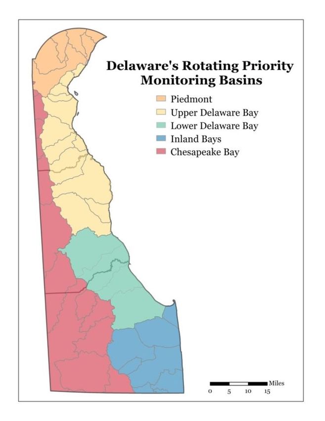
Executive Summary
Delaware’s Surface Water Quality Monitoring Program for Fiscal Year 2022 as
conducted by Delaware Department of Natural Resources and Environmental Control
(DNREC) is described in this report. Elements of Delaware’s monitoring program
include: General Assessment Monitoring, Chesapeake Non-tidal Monitoring, Continuous
Water Quality Monitoring, Biological Assessment Monitoring, Toxics in Biota
Monitoring, Toxics in Sediment Monitoring, and Monitoring under the Watershed
Approach to Toxics Assessment and Restoration (WATAR) Plans. Each element of the
monitoring program is briefly described below:
   •   Delaware maintains a General Assessment Monitoring Network (GAMN).
       GAMN stations are considered long term stations whose data is used to perform
       long term status and trend assessments of water quality conditions of the State’s
       surface waters and support compilation of Watershed Assessment Reports as
       mandated by the Clean Water Act under section 305(b). In addition, the data is
       used to calculate annual nutrients and other pollutants loads, and to track progress
       toward achieving the targets established by the Total Maximum Daily Loads
       (TMDLs) for many of the watersheds of the State. Furthermore, the data will be
       used to identify effect of land use on N and P concentrations. The State’s GAMN
       currently has a total of 139 stations. 23 of the monitoring stations are considered
       category 1 stations (C1) and are monitored monthly. These stations are co-
       located with a United States Geological Survey (USGS) stream gaging station or
       are located at the mouth of a tidal river. The remaining 116 monitoring stations
       are Category 2 (C2) stations and are monitored monthly for 2 years and bi-
       monthly for 3 years according to a 5-year rotating basin schedule. 4 storm
       samples (one per season) are collected annually at 12 C1 and C2 sites statewide
       shown at the end of Table 1. During FY 2022, Inland Bays and Upper Delaware
       Bay Drainage Basins are the priority basins and all stations in these two basins are
       monitored every month. Monitoring frequency at stations in the other 3 basins
       (Lower Delaware Bay, Piedmont, and Chesapeake Bay) will be bi-monthly.
   •   Delaware DNREC is participating in the Chesapeake Bay Program’s Non-tidal
       Monitoring Program and collects samples from two of the non-tidal sites located
       in Delaware. These two sites are Nanticoke River near Bridgeville and
       Marshyhope Creek at Fishers Bridge Rd. Samples at these two sites are collected
       according to sample collection protocol developed by the Chesapeake Bay
       Program Non-tidal Monitoring Workgroup. Monthly samples and 8 storm
       samples per year (2 storm samples per season) are collected at these two sites.
       The data collected at these two sites are provided to the Chesapeake Bay Program
       and are used for calibrating the Chesapeake Bay Watershed Model. The data are
       also used to monitor water quality status and to perform trend analysis.
   •   Delaware DNREC, in cooperation with the Delaware Geological Survey (DGS)
       and the United States Geological Survey (USGS), is maintaining 6 continuous
       water quality monitoring sites. In the 6 continuous water quality monitoring sites,
       monitoring of water temperature, dissolved oxygen (DO), pH, and specific
       conductance at these sites are conducted at fifteen-minute intervals by using
       multi-parameter water-quality sondes (YSI sondes).

                                            1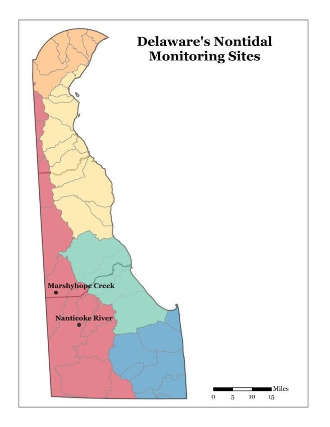
•   During FY 2022, Delaware DNREC will not conduct any new habitat/biological
    survey. Instead, it will review the results of surveys conducted during the past
    several years to evaluate the condition of habitat/biota and to identify any areas
    where data gap exist and where additional monitoring is needed. Future
    habitat/biological monitoring will be based on the findings of this data review and
    analysis.
•   During FY2022 DNREC’s WATAR Team plans to focus on fish tissue sample
    collection from the Christina Basin and Shellpot Creek. In addition, the team will
    attempt to sample fish tissue from Army Creek and the Appoquinimink River,
    which sampling team were unable to collect in FY 2021 due to COVID related
    sampling restrictions.

                                         2
Ambient Surface Water Quality Monitoring Program - FY 2022
The purpose of the Ambient Surface Water Quality Monitoring Program is to collect data
on the chemical, physical, and biological characteristics of Delaware's surface waters.
The information that is collected under this program is used to:
Describe surface water quality conditions in the State;
Identify long term trends in surface water quality;
Determine the suitability of Delaware surface waters for water supply, recreation, fish
and aquatic life, and other uses;
Monitor achievement of Surface Water Quality Standards;
Identify and prioritize high quality and degraded surface waters;
Calculate annual nutrient and select metal loads and track progress toward achieving
Total Maximum Daily Load (TMDL) targets; and
Evaluate the overall success of Delaware's water quality management efforts.
Major components of Delaware's Surface Water Quality Monitoring Program include the
following:
General Assessment Monitoring
Chesapeake Non-tidal Monitoring
Continuous Water Quality Monitoring
Biological Assessment Monitoring
Toxics in Biota Monitoring
Toxics in Sediment Monitoring
Monitoring under the Watershed Approach to Toxics Assessment and Restoration
(WATAR) Plan.
This report discusses the General Assessment Monitoring in detail. In addition, it briefly
discusses other components of the Delaware’s Surface Water Quality Monitoring
Program including the Biological Assessment Monitoring, Toxics in Biota Monitoring,
Toxics in Sediment Monitoring, and WATAR monitoring.
3Figure 1 – State of Delaware Watersheds and Basins
4The General Assessment Monitoring Network (GAMN)
The General Assessment Monitoring Network (GAMN) provides for routine water
quality monitoring of surface waters throughout the State of Delaware. Currently the
monitoring network includes 139 monitoring stations (see Table 1). Each station is
monitored for conventional parameters such as nutrients, bacteria, dissolved oxygen, pH,
alkalinity, and hardness (Table 2). Some stations are monitored for dissolved metals as
well as the parameters that are needed to conduct Biotic Ligand Model (BLM) analysis
for metals toxicity (see Tables 1, 3 and 4).
The data collected as part of this effort is entered into the EPA’s STORET database. In
addition, the data is reviewed and analyzed to assess water quality condition of the
State’s waters to be included in the Integrated Watershed Assessment Report (CWA
Sections 305 (b)/303(d) Report) which Delaware Department of Natural Resources and
Environmental Control produces every 2 years. Furthermore, the data is used to assess
water quality status and trends as well as tracking progress toward achieving water
quality standards and TMDL targets.
As stated earlier, the GAMN currently has a total of 139 stations. These stations fall into
2 categories:
a. C1 - Category 1 stations are high priority stations. Currently, GAMN contains 23
Category 1 sites. Data collected at C1 Stations are used for calculating annual
loads and long-term trends. These stations are generally co-located with a United
States Geological Survey (USGS) stream gaging station or are located at the
mouth of a tidal river. Monitoring at these stations is conducted monthly,
regardless of rotating priority basin schedule. In addition, annually 4 storm
samples (1 per season) are collected at these sites.
b. C2 - The remaining 116 stations are Category 2 stations and are monitored
monthly for 2 years and bi-monthly for 3 years according to a 5-year rotating
priority basins schedule.
Figure 2 shows the location of monitoring sites and C1 and C2 stations. During FY 2022,
the Inland Bays and Upper Delaware Bay Drainage Basins are priority basins and all
stations in these two basins are monitored monthly. Stations in the 3 remaining basins
(Lower Delaware Bay, Piedmont, and Chesapeake Bay) are monitored 6 times per year
(bi-monthly). Figure 3 shows Delaware’s Priority Rotating Basins.
Data collected as part of this monitoring effort is archived in the US EPA’s STORET
data base. In addition, the data can be viewed or downloaded from the University of
Delaware’s Environmental Observatory System (DEOS) Water Quality Data Portal site at
the following url: http://demac.udel.edu/waterquality/
5Figure 2 - Delaware's Surface Water Quality Monitoring Sites
6Figure 3 - Delaware's Rotating Priority Monitoring Basins
7Chesapeake Bay Non-tidal Monitoring
Delaware DNREC is participating in a multi-State non-tidal monitoring Program
conducted by the Chesapeake Bay Program and other jurisdictions including Maryland,
Virginia, West Virginia, Pennsylvania, New York, and the District of Columbia. The
Chesapeake Bay Non-tidal Monitoring Network has about 120 monitoring sites and the
following two sites are in Delaware:
1. Nanticoke River near Bridgeville
2. Marshyhope Creek at Fishers Bridge Rd
Location of the Chesapeake Bay Non-tidal monitoring sites in Delaware is shown in
Figure 4. Monitoring at the above two sites is conducted monthly using sample
collection protocol developed by the Chesapeake Bay Program Non-tidal Monitoring
Workgroup [1]. In addition to monthly sampling, 8 storm samples per year (2 per
season) are collected at these sites.
Figure 4 - Delaware's Non-tidal Monitoring Sites
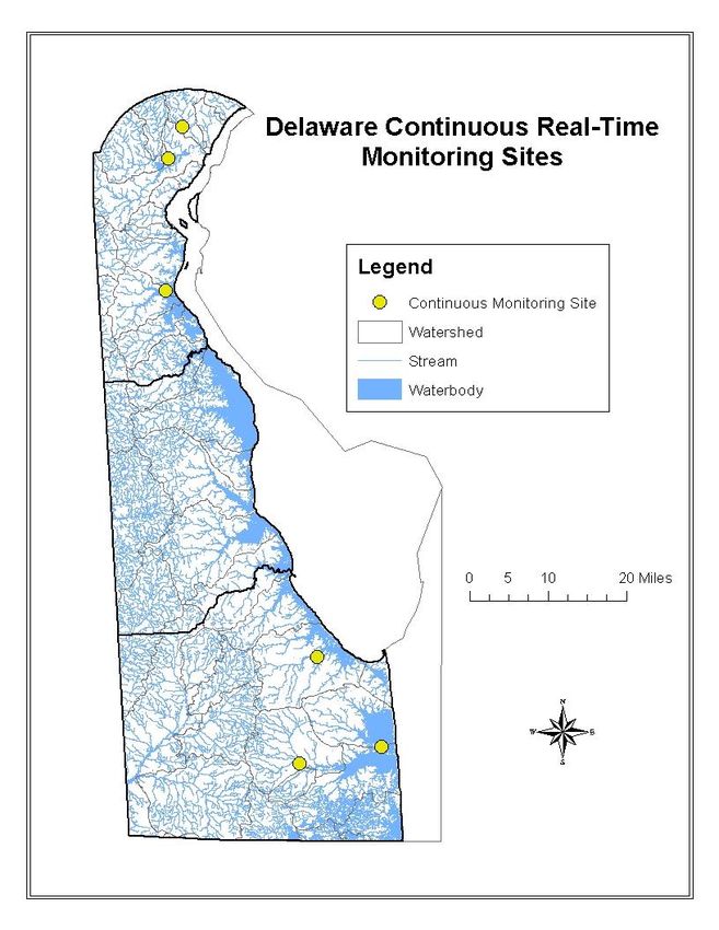
8Continuous Water Quality Monitoring
Delaware DNREC, in cooperation with the Delaware Geological Survey (DGS) and the
United States Geological Survey (USGS), is maintaining a number of continuous
Monitoring sites in the State. During FY 2022, six sites in Delaware are being monitored
continuously. These sites include:
1. Brandywine Creek at Wilmington
2. Christina River at Newport
3. Appoquinimink River near Odessa
4. Millsboro Pond Outlet at Millsboro
5. Broadkill River near Milton
6. Massey Ditch at Massey Landing
Figure 5 shows the location of the above continuous monitoring sites. Measurements of
water temperature, dissolved oxygen (DO), pH, and specific conductance at these sites
are conducted at every fifteen minutes interval by using multi-parameter water-quality
data sondes (such as YSI sondes). All data are collected following USGS protocols and
are stored in USGS National Water Information System (NWIS) databases,
http://waterdata.usgs.gov/de/nwis/current/?type=quality
9Figure 5 - Delaware's Continuous Monitoring Sites
10Biological Assessment Monitoring
To assess habitat and biological integrity of Delaware’s surface waters, Delaware
DNREC conducts habitat and biological monitoring of its streams. Macroinvertebrate
and habitat assessments are generally performed at perennial, non-tidal, wadable streams
throughout the State of Delaware using a probabilistic design. Random sites are selected
through the assistance by the Environmental Protection Agency (EPA) using an EMAP
approach. Randomization of sites will allow for a statewide, unbiased probability-based
estimate of stream conditions throughout the state. Data from this survey will be used for
305(b) analysis.
During FY 2022, Delaware DNREC is not conducting any new habitat/biological survey.
Instead, it will review the results of surveys conducted over the past several years to
evaluate the condition of habitat/biota and to identify any areas where data gap exist and
where additional monitoring is needed. Future habitat/biological monitoring will be
based on the findings of this data review and analysis.
Toxics in Biota Monitoring
The FY 2022 Toxics in Biota Monitoring program is being incorporated into the
WATAR monitoring effort (see below).
Toxics in Sediment Monitoring
The FY 2022 Toxics in Sediment Monitoring program is being incorporated into the
WATAR monitoring effort (see below).
Monitoring under the Watershed Approach to Toxics Assessment and
Restoration (WATAR) Plan
In FY 2022, the WATAR team plans to focus its annual sampling efforts on fish tissue in
the Christina Basin and Shellpot Creek. In addition, the team will attempt to collect fish
tissue samples from Army Creek and the Appoquinimink River in FY 2022. Field
sampling in FY 2021 was severely restricted due to COVID-19, and planned sampling
was not able to be conducted. The data collected will inform/extend fish tissue trend
assessments that were compiled and submitted to USEPA in 2018. The data will also be
used to update fish advisories for the areas sampled. Additional surface water and/or
sediment sampling will also be conducted in support of potential TMDL development for
DxF TEQs and DDT and metabolites in the Red Clay Creek. For more detailed
information on planned activities and field work, please refer to the WATAR 5-year
workplan for 2018-2022 [2 and 5].
11Field and Laboratory Procedures
Field procedures for sample collection activities are detailed in DNREC’s Environmental
Laboratory Services Quality Manual [3]. Method references, STORET codes and
reporting levels for parameters listed in Table 2 are provided by the DNREC’s
Environmental Laboratory Section. Any deviation from standard field, laboratory
procedures, or this sampling plan shall be documented with a complete description of the
alteration.
Quality Assurance, Documentation, Data Usage and Reporting
The quality assurance objectives and quality control procedures for these surveys are
documented in the Quality Assurance Project Plan prepared by the Watershed
Assessment and Management Section, Division of Watershed Stewardship [4].
A duplicate water column sample will be collected and analyzed on 10% of the samples
from this project. All analytical results from the duplicate analyses shall be reported with
the other data.
All analytical results shall be reported to the Watershed Assessment and Management
Section digitally (using standard Environmental Laboratory Section’s data report forms).
12Table 1 - Station Locations, Descriptions, Parameters, and Sampling Frequency
BLM Parameters
Copper, Lead
Arsenic (As)
Category
and Zinc
Iron (Fe)
BASIN PROJECT SITE DESCRIPTION STORET Freq.
Little Mill Creek @ DuPont Rd. 106281 C2 6 X X
Christina River near Conrail Bridge 106291 C1 12 X X
Brandywine Creek @ Foot Bridge in
104011 6 X X
Brandywine Park C2
Brandywine Creek @ New Bridge Rd. (Rd.
104021 12 X X
279) C1
Red Clay Creek @ Lancaster Pike (Rt. 48) 103031 C1 12 X X
Red Clay Creek @ Barley Mill Rd. (Rd. 258A) 103041 C2 6 X X
Burroughs Run @ Creek Rd. (Rt. 82) 103061 C2 6 X X
Brandywine Creek @ Smith Bridge Rd. (Rd.
North Piedmont 104051 6 X X
221) C2
Christina River beneath Rt. 141 Bridge 106021 C2 6 X X
Red Clay Creek @ W. Newport Pike (Rt. 4) 103011 C2 6 X X
White Clay Creek @ Delaware Park Blvd. 105151 C1 12 X X
PIEDMONT White Clay Creek @ McKees Lane 105171 C2 6 X X
Christina River @ Nottingham Rd. (Rt. 273) 106191 C2 6 X X
White Clay Creek @ Chambers Rock Rd. (Rd.
105031 6 X X
329) C2
Christina River @ Sunset Lake Rd. (Rt. 72) 106141 C1 12 X X
Smalleys Dam Spillway @ Smalleys Dam Rd. 106031 C2 6 X X
Naaman Creek S. Branch @ Darley Rd. (Rd.
101031 6
207) C2
Naaman Creek @ State Line near Hickman
101021 6
Rd. C2
Northeast Naaman Creek South Branch @ Marsh Rd.
Piedmont 101061 6
(Rt. 3) C2
Shellpot Creek @ Carr Rd. 102081 C2 6
Shellpot Creek @ Market St. (Rt. 13 Bus.) 102051 C1 12
Shellpot Creek @ Hay Rd. (Rd. 501) 102041 C2 6 X
Army Creek @ S. DuPont Hgwy. (Rt. 13) 114021 C2 12
13BLM Parameters
Copper, Lead
Arsenic (As)
Category
and Zinc
Iron (Fe)
BASIN PROJECT SITE DESCRIPTION STORET Freq.
Army Creek @ Rt. 13 near Rt. 40 114051 C2 12
Trib Army Crk. @ Rt. 13 near Airport Ind. Park 114041 C2 12
Army Creek @ River Rd. (Rt. 9) 114011 C2 12
Red Lion Creek @ Rt. 9 107031 C2 12
North Delaware
Dragon Creek @ Wrangle Hill Rd. (Rt. 9) 111011 C2 12
Bay
C & D Canal @ DuPont Pkwy. (Rt. 13) N. side 108021 C2 12
Dragon Creek @ S. DuPont Hwy. (Rt. 13) 111031 C2 12
Red Lion Creek @ Bear Corbitt Rd. (Rt. 7) 107011 C2 12
Lums Pond @ Boat Ramp 108111 C2 12
Drawyer Creek off Rt. 13 @ parking area 109071 C2 12 X X
Shallcross Lake @ Shallcross Lake Rd. (Rd.
109191 12 X X
420) C2
Deep Creek Branch @ Summit Bridge Rd. (Rt.
109251 12 X X
71) C1
Appoquinimink Noxontown Pond @ Noxontown Rd. (Rd. 38) 109131 C2 12 X X
River
UPPER Appoquinimink River @ DuPont Pkwy. (Rt. 13) 109041 C2 12 X X
DELAWARE Appoquinimink River @ MOT Gut (west bank) 109171 C2 12 X X
BAY Appoquinimink River @ Silver Run Rd. (Rt. 9)
109121 12 X X
NE C2
Appoquinimink River @ Mouth 109091 C1 12 X X
Little River @ Bayside Dr. (Rt. 9) 204031 C2 12
Little River @ N. Little Creek Rd. (Rt. 8) 204041 C2 12
Leipsic River @ Denny St. (Rt. 9) 202031 C2 12
Smyrna River @ Flemings Landing (Rt. 9) 201041 C2 12
Blackbird Creek @ Taylors Bridge Rd. (Rt. 9) 110041 C2 12
Delaware Bay Blackbird Creek @ Blackbird Station Rd. (Rd.
110011 12
Drainage 463) C1
Blackbird Creek @ Blackbird Landing Rd. (Rd.
110031 12
455) C2
Duck Creek @ Smyrna Landing Rd. (Rd. 485) 201051 C2 12
Mill Creek (Lake Como outfall) @ Rt. 13 201011 C2 12
Providence Creek @ Duck Creek Rd. (Rt. 15) 201161 C2 12
Mill Creek @ Carter Rd. (Rd. 137) 201021 C2 12
14BLM Parameters
Copper, Lead
Arsenic (As)
Category
and Zinc
Iron (Fe)
BASIN PROJECT SITE DESCRIPTION STORET Freq.
Garrisons Lake @ DuPont Hwy. (Rt. 13) 202021 C2 12
Leipsic River @ Mt. Friendship Rd. (Rt. 15) 202201 C2 12
St. Jones River @ mouth, Bowers Beach 205011 C1 12
St. Jones River @ Barkers Landing 205041 C2 12
St. Jones River @ East Lebanon Rd. (Rt. 10) 205091 C2 12
St. Jones River Derby Pond @ Boat Ramp (Rt. 13A) 205211 C2 12
Moores Lake @ S. State St. (Rd. 27) 205181 C2 12
Fork Branch @ State College Rd. (Rd. 69) 205151 C2 12
Silver Lake @ Spillway (Dover City Park) 205201 C2 12
Murderkill River @ Rt. 13 206011 C1 12 X X
Browns Branch @ Milford-Harrington Hwy.
206041 6 X X
(Rt. 14) C2
McColley Pond @ Canterbury Rd. (Rt. 15) 206361 C2 6 X X
Coursey Pond @ Canterbury Rd. (Rt. 15) 206451 C2 6 X X
Double Run @ Barratts Chapel Rd. (Rd. 371) 206561 C2 6 X X
Murderkill River Murderkill River @ Bowers Beach Wharf
206101 12 X
(mouth) C1
Murderkill River near levee @ MNWA (RM
206141 6 X X
3.25) C2
Murderkill Rv. @ confl. of KCWWTF discharge
206231 6 X X
LOWER ditch C2
DELAWARE Murderkill River @ Bay Rd. (Rt. 1/113) 206091 C2 6 X X
BAY Beaverdam Branch @ Deep Grass Ln. (Rd.
208231 12
384) C1
Abbotts Pond @ Abbotts Pond Rd. (Rd. 620) 208181 C2 6
Silver Lake @ Maple Ave. 208211 C2 6
South Delaware Mispillion River @ Rt. 1 208021 C2 6
Bay
Mispillion River @ Cedar Creek confluence 208061 C1 12
Cedar Creek @ Cedar Beach Rd. (Rt. 36) 301091 C2 6
Cedar Creek @ Coastal Hwy. (Rt. 1) 301031 C2 6
Swiggetts Pond @ Cedar Creek Rd. (Rt. 30) 301021 C2 6
Savannah Ditch @ Savannah Drive (Rd. 246) 303011 C2 6
Broadkill River
Ingram Branch @ Gravel Hill Rd. (Rd. 248) 303021 C2 6
15BLM Parameters
Copper, Lead
Arsenic (As)
Category
and Zinc
Iron (Fe)
BASIN PROJECT SITE DESCRIPTION STORET Freq.
Beaverdam Creek @ Carpenter Rd. (Rd. 259) 303181 C2 6
Beaverdam Creek @ Cave Neck Rd. (Rd. 88) 303171 C2 6
Round Pole Branch @ Cave Neck Rd. (Rd.
303311 6
88) C2
Broadkill River @ Union St (Rt. 5) 303031 C2 6
Pemberton Branch @ Gravel Hill Rd. (Rt. 30) 303341 C2 6
Red Mill Pond @ Rt. 1 303051 C2 6
Broadkill River 0.10 Miles From Mouth 303061 C1 12
Broadkill River @ Rt. 1 Bridge 303041 C2 6
Waples Pond @ Rt. 1 303331 C2 6
Indian River Inlet @ Coast Guard Station 306321 C1 12 X X
Little Assawoman Bay Mid-Bay (Ocean Park
310071 12 X X
Lane) C2
Little Assawoman Bay @ Rt. 54 (The Ditch) 310011 C2 12 X X
Dirickson Creek @ Old Mill Bridge Rd. (Rd.
310031 12 X X X
381) C2
Beaver Dam Ditch @ Beaver Dam Rd. (Rd.
310121 12 X X X
368) C1
Blackwater Creek @ Omar Rd. (Rd. 54) 308361 C2 12 X X X
White Creek @ mouth of Assawoman Canal 312011 C2 12 X X
Inland Bays w/ Bundicks Branch @ Rt. 23 308371 C2 12 X X X
INLAND BAYS Pocomoke & Pocomoke River @ Bethel Rd. (Rd. 420) 313011 C2 12
Delaware Bay Whartons Branch @ Rt. 20 (Dagsboro Rd.) 309041 C2 12 X X X
Pepper Creek @ Rt. 26 (Main St.) 308091 C2 12 X X X
Buntings Branch @ Rt. 54 (Polly Branch Rd.) 311041 C2 12 X X X
Millsboro Pond @ Rt. 24 308071 C1 12 X X X
Cow Bridge Branch @ Zoar Rd. (Rd. 48) 308281 C2 12 X X X
Swan Creek @ Mount Joy Rd. (Rd. 297) 308341 C2 12 X X X
Guinea Creek @ Banks Rd. (Rd. 298) 308051 C2 12 X X X
Burton Pond @ Rt. 24 308031 C2 12 X X X
Indian River @ Buoy 49 (Swan Creek) 306181 C2 12 X X
Indian River @ Island Creek 306331 C2 12 X X
16BLM Parameters
Copper, Lead
Arsenic (As)
Category
and Zinc
Iron (Fe)
BASIN PROJECT SITE DESCRIPTION STORET Freq.
Island Creek upper third 306341 C2 12 X X
Indian River Bay @ Buoy 20 306121 C1 12 X X
Massey Ditch @ Buoy 17 306111 C2 12 X X
Rehoboth Bay @ Buoy 7 306091 C2 12 X X
Lewes & Rehoboth Canal @ Rt. 1 305011 C2 12 X X
Lewes & Rehoboth Canal @ Rt. 9 305041 C2 12 X X
Roosevelt Inlet, mouth 401011 C2 12
Raccoon Prong @ Pepperbox Rd. (Rd. 66) 307371 C2 6 X X
Hitch Pond Branch @ Pepper Pond Rd. (Rd.
307081 6 X X
449) C2
Nanticoke River @ Rt. 13 304471 C2 6 X X
Concord Pond @ German Rd. (Rd. 516) 304311 C2 6 X X
Deep Creek @ Old Furnace Rd. (Rd. 46) 304741 C2 6 X X
Gravelly Branch @ Coverdale Rd. (Rd. 525) 316011 C2 6 X X
Gravelly Branch @ Deer Forest Rd. (Rd. 565) 316031 C2 6 X X
Nanticoke River @ Beach Hwy. (Rt. 16) 304681 C2 6 X X
Nanticoke River
Clear Brook @ Cannon Rd. (Rt. 18) 304371 C2 6 X X
Bucks Branch @ Conrail Rd. (Rd. 546) 304381 C2 6 X X
Williams Pond @ East Poplar St. 304321 C2 6 X X
CHESAPEAKE
Broad Creek @ Bethel Rd. (Rd. 493) 307031 C2 6 X X
Records Pond @ Willow Street 307011 C2 6 X X
Horsey Pond @ Sharptown Rd. (Rt. 24) 307171 C2 6 X X
Nanticoke River @ Sharptown 304011 C2 6 X X
Nanticoke River @ Buoy 66 (mouth of DuPont
304151 6 X X
Gut) C2
Sewell Branch @ Sewell Branch Rd. (Rd. 95) 112021 C2 6
Tappahanna Ditch @ Sandy Bend Rd. (Rd.
207081 6
Chesapeake 222) C2
Drainage Culbreth Marsh Ditch @ Shady Bridge Rd.
207091 6
(Rd. 210) C2
Cow Marsh Creek @ Mahan Corner Rd. (Rd.
207021 6
208) C2
17BLM Parameters
Copper, Lead
Arsenic (As)
Category
and Zinc
Iron (Fe)
BASIN PROJECT SITE DESCRIPTION STORET Freq.
White Marsh Br. @ Cedar Grove Church Rd.
207111 6
(Rd. 268) C2
Nanticoke River @ Rifle Range Rd. (Rd. 545) 304191 C1 12 X X
Chesapeake Bay
Nontidal Marshyhope Creek @ Fishers Bridge Rd. (Rd.
302031 12 X X
258) C1
Nanticoke River @ Rifle Range Rd. (Rd. 545) 304201 C1 8 X X
Chesapeake Bay
Nontidal Storm Marshyhope Creek @ Fishers Bridge Rd. (Rd.
302031 8 X X
258) C1
Shellpot Creek @ Market St. (Rt. 13 Bus.) 102051 C1 4
Brandywine Creek @ New Bridge Rd. (Rd.
104021 4 X X
279) C1
Red Clay Creek @ Lancaster Pike (Rt. 48) 103031 C1 4 X X
White Clay Creek @ Delaware Park Blvd. 105151 C1 4 X X
Christina River @ Sunset Lake Rd. (Rt. 72) 106141 C1 4 X X
Deep Creek Branch @ Summit Bridge Rd. (Rt.
109251 4 X X
71) C1
State-Wide Storm Blackbird Creek @ Blackbird Station Rd. (Rd.
110011 4
463) C1
Murderkill River @ Rt. 13 206011 C1 4 X X
Millsboro Pond @ John Williams Hwy. (Rt. 24) 308071 C1 4 X X X
Silver Lake @ Spillway (Dover City Park) 205201 C2 4
Beaver Dam Ditch @ Beaver Dam Rd. (Rd. C1 4
310121
368)
Beaverdam Branch @ Deep Grass Ln. (Rd.
208231 C1 4
384)
18Table 2 - Water Quality Parameters to be monitored at all stations - FY 2022
Parameter Method Reference1 Reporting Level2
Water Column Nutrients
Ammonia Nitrogen EPA 350.1, Rev. 2.0 (1993) 0.010 mg/l N
Nitrite+Nitrate Nitrogen EPA 353.2, Rev. 2.0 (1993) 0.010 mg/l N
Nitrogen, Total, Alkaline Persulfate SM 4500-P J-2011 0.100 mg/l N
Soluble Ortho-phosphorus EPA 365.1, Rev. 2.0 (1993) 0.005 mg/l P
Phosphorus, Total, Alkaline Persulfate SM 4500-P J-2011 0.010 mg/l P
Carbon and Organics
Total Organic Carbon SM 5310 B-2011 1 mg/l
Dissolved Organic Carbon SM 5310 B-2011 1 mg/l
Chlorophyll-a (Corr) EPA 445.0, Rev. 1.2 (1997) 1 µg/l
Biochemical Oxygen Demand
BOD5, N-Inhib (CBOD) SM 5210 B-2011 2.4 mg/l
BOD20, N-Inhib (CBOD) SM 5210 B-2011 2.4 mg/l
Field Measurements
Conductivity SM 2510 B-2011 1 µS/cm
Dissolved oxygen SM 4500-O G-2011 or 0.1 mg/l
ASTM D888-09 (C)
pH - Field SM 4500-H+ B-2011 0.2 pH units
Salinity SM 2520 B-2011 0.1 ppt
Temperature SM 2550 B-2010 Water -5.00 oC
Air -10 oC
Secchi Depth3 EPA-841-R-14-007 0.1 meters
4
Light Attenuation EPA-841-R-14-007 0.1 µmol/s/m2
General
Alkalinity SM 2320 B-2011 2.3 mg/l
Chloride SM 4500-Cl− E-2011 3 mg/l
Hardness SM 2340 C-2011 5 mg/l as CaCO3
Total Suspended Solids SM 2540 D-2011 2.5 mg/l5
Turbidity SM 2130 B-2011 1 NTU
Bacteria
Enterococcus Enterolert® 1 mpn/100 ml
191
SM refers to Standard Methods.
2
The Environmental Laboratory Section defines the Limit of Quantitation (LOQ) as the lowest standard in
the calibration curve or, in instances where a standard curve is not specified by the procedure, LOQ
represents the limitations of the method. For those tests where reference spiking material exists, the ELS
measures Method Detection Limit (MDL), as defined in the Federal Register 40 CFR Part 136 Appendix
B. MDL values are generated or verified once per year. Results less than the MDL are considered to be
not detected and “< MDL” is reported. Results greater than the MDL but less than the LOQ are qualified
with a J to indicate a result that is extrapolated or estimated. For tests where MDL is not applicable,
results less than the LOQ are reported as “< LOQ”. ELS MDLs meet or exceed (i.e., are lower than) the
reporting level requirements listed in Table 3. The reporting levels listed represent the LOQ or method
defined limit.
3
Secchi Depth to be measured at designated stations. The reappearance depth is recorded.
4
Light attenuation to be conducted as practical to obtain correlation with Secchi disk readings. PAR at
the surface and at one meter depth is recorded and reported.
5
Reporting Limit based on 1000 ml filtration volume. The reporting limit will be adjusted according to
actual volume filtered. The method specifies to decrease volume if complete filtration takes more than 10
minutes.
Table 3 - Metal Parameters
Dissolved Metals Method Reference (EPA) Reporting Level6
Copper EPA 200.8, Rev. 5.4 (1994) 1.0 ug/l
Lead EPA 200.8, Rev. 5.4 (1994) 1.0 ug/l
Zinc EPA 200.8, Rev. 5.4 (1994) 2.0 ug/l
Iron EPA 200.7, Rev. 4.4 (1994) 100 ug/l
Arsenic EPA 200.8, Rev. 5.4 (1994) 1.0 ug/l
6
High levels of dissolved solids in the sample may cause analytical interferences. For example, EPA
method 200.8 recommends that the dissolved solids levels not exceed 0.2% (w/v) (~2,000 mg/L) to reduce
such effects. Samples may be diluted during analysis to minimize the instrument interferences associated
with high salinity/conductivity. The reported MDLs and LOQs for the parameters will be adjusted due to
the sample dilution.
20Table 4 - Additional parameters needed for freshwater stations with Biotic Ligand
Model Sampling for Copper (BLM Parameters)
Reporting
Dissolved Parameters Method Reference (EPA)
Level
Alkalinity SM 2320 B-2011 2.3 mg/l
−
Chloride SM 4500-Cl E-2011 3 mg/l
Calcium EPA 200.7, Rev. 4.4 (1994) 1000 ug/l
Magnesium EPA 200.7, Rev. 4.4 (1994) 1000 ug/l
Potassium EPA 200.7, Rev. 4.4 (1994) 1000 ug/l
Sodium EPA 200.7, Rev. 4.4 (1994) 1000 ug/l
Sulfate EPA 300.0 0.75 mg/l
References:
1. Chesapeake Bay Program. 2008. Chapter V, Non-tidal Water Quality Monitoring.
Annapolis, MD.
2. DNREC. 2017. Quality Assurance Project Plan - Collection and Analysis of Surface
Water, Sediment and Fish Tissue Samples for Toxics in Delaware Watersheds that
Flow to the Chesapeake Bay. Division of Watershed Stewardship, Delaware
Department of Natural Resources and Environmental Control, Dover, DE.
3. DNREC. 2019. Quality Manual for DNREC Environmental Laboratory and Field
Operations, Environmental Laboratory Section, Division of Water.
4. DNREC. 2019. Delaware Ambient Surface Water Quality Monitoring Program
Quality Assurance Program Plan (QAPrP), Division of Watershed Stewardship,
Watershed Assessment and Management Section.
5. DNREC. 2018. Watershed Approach to Toxics Assessment and Restoration 2018-
2022. DNREC Division of Watershed Stewardship and Division of Waste and
Hazardous Substances.
21You can also read