STRONG-MOTION SEISMOGRAPH NETWORK - OPERATED BY NIED: K-NET AND KIK-NET
←
→
Page content transcription
If your browser does not render page correctly, please read the page content below

Journal of Japan Association for Earthquake Engineering, Vol. 4, No. 3 (Special Issue), 2004

     STRONG-MOTION SEISMOGRAPH NETWORK
       OPERATED BY NIED: K-NET AND KiK-net

                     Shin AOI1, Takashi KUNUGI2, and Hiroyuki FUJIWARA3
     1
         Senior Researcher, National Research Institute for Earth Science and Disaster Prevention,
                                      Tsukuba, Japan, aoi@bosai.go.jp
            2
              Researcher, National Research Institute for Earth Science and Disaster Prevention,
                                    Tsukuba, Japan, kunugi@bosai.go.jp
         3
           Project Director, National Research Institute for Earth Science and Disaster Prevention,
                                   Tsukuba, Japan, fujiwara@bosai.go.jp

     ABSTRACT: After the 1995 Hyogoken-Nanbu earthquake, NIED (National Research
     Institute for Earth Science and Disaster Prevention) installed the K-NET that uniformly
     covers all Japan with more than one thousand strong-motion accelerometers on the
     ground surface. In addition to the K-NET, NIED constructed an uphole/downhole
     observation network, KiK-net, with approximately 669 stations. Each KiK-net station
     has a borehole of 100 m or more in depth and strong-motion seismographs have been
     installed both on the ground surface and at the bottom of the boreholes. The velocity
     profiles and geological information as well as the observed records are widely accessible
     on the website.

     Key Words: Strong-motion, seismograph network, K-NET, KiK-net

                                            INTRODUCTION

During the 1995 Hyogoken-Nanbu (Kobe) earthquake, only few strong motion stations recorded data
in the ‘Damaged belt’. Ground motion observation in such a damaged area is a central matter for
interpreting the earthquake impact. Based on the lessons from the 1995 Hyogoken-Nanbu
earthquake and the measures for the next supposed large earthquakes in/around Japan, the National
Research Institute for Earth Science and Disaster Prevention (NIED) constructed two strong motion
seismograph networks, K-NET (Kinoshita, 1998) and KiK-net (Aoi et al., 2000). Station
distributions for these networks are designed to cover all Japan as uniformly as possible with the
instrumentation for most stations being of the same type. The main difference between these two
networks is that K-NET is an observation network, which records data only on the free surface, and
KiK-net has boreholes with installed sensors located both at the bottom of the borehole and on the
surface.

K-NET (Kyoshin NETwork)

Just after the 1995 Hyogoken-Nanbu earthquake, construction of K-NET began and was completed in
just over one year (Kinoshita, 1997). The term K-NET stands for ‘Kyoshin network’ where
‘Kyoshin’ means ‘strong motion’ in Japanese. At its inception, K-NET consisted of 1000 stations

                                                     - 65 -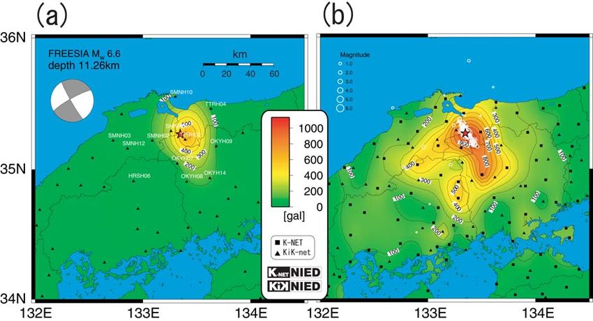
whose average station-to-station distance was about 20 km. All the stations were outfitted with the
same type of strong motion accelerometers, K-NET95, which were installed on the free surface.
Afterward, some stations were added to K-NET, such as the existing stations within the Kanto-Tokai
area or the cable type ocean-bottom strong motion accelerometers at the Sagami Bay. The number of

                                                            Table 1. Distribution of the
                                                            KiK-net borehle depth.

                                                              Table 2. Stations that have a
                                                              borehole depth greater than
                                                              1000 m.

Fig. 1. Distribution of (a) K-NET and (b) KiK-net stations. Red and blue circles in (a) show
stations whose outfitted with instruments of K-NET95 and K-NET02, respectively. Color in
(b) indicates borehole depth. The yellow square shows the DMC of NIED located in Tsukuba.

                                               - 66 -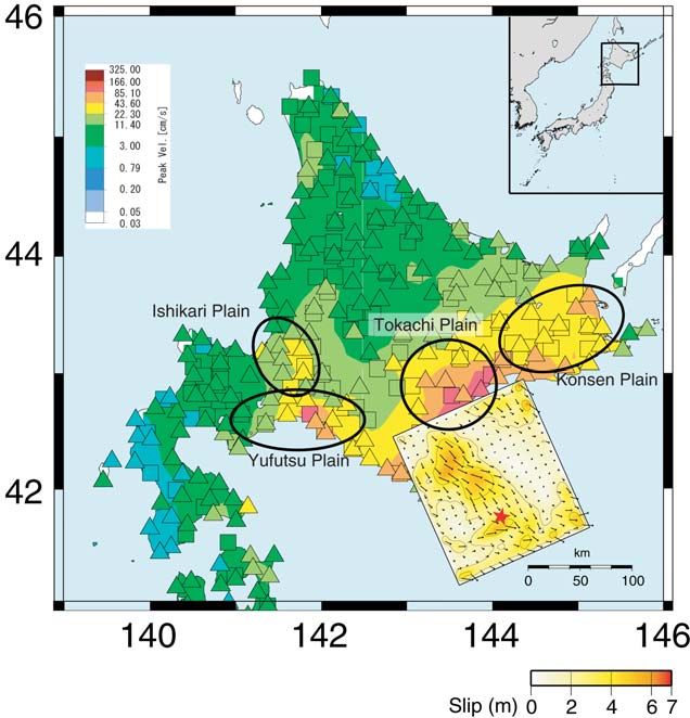
Fig. 2. Observation facility for (a) K-NET and (b) KiK-net. Tri-axis strong-motion
    accelerometers are installed on the free surface for both networks. For the KiK-net,
    a strong-motion accelerometer is also installed at the bottom of the borehole stored in
    a pressure-resistant tube made of stainless steel together with the high-sensitivity
    seismographs (Hi-net). (c) shows a downhole instrument for KiK-net.

stations currently is 1030, and this amount varies as new stations are added or old stations are taken
off-line.

KiK-net (Kiban Kyoshin network)

The Japanese government established ‘the Headquarters for Earthquake Research Promotion’ on July
18, 1995, and the ‘Fundamental Survey and Observation for Earthquake Research’ plan was developed
under their direction. In short, this plan is called KIBAN, which is a Japanese word meaning
fundamental or infrastructure. The main part of the ‘Kiban’ project consists of the total observation
network (Okada et al., 2004), which is composed of several different types of observation networks:
the high sensitivity seismic network (Hi-net; Obara et al., 2002), the strong motion observation
network (KiK-net; Kiban Kyoshin network, Aoi et al., 2000), the broadband seismic observation
network (F-net, Fukuyama et al., 1996), and the continuous GPS observation network (GEONET;
Geographical Survey Institute, 1998). Each KiK-net station has an observation borehole of more
than 100 m deep. Strong motion seismographs are installed on the ground surface and also at the
bottom of the observation boreholes together with high sensitivity velocity seismographs for Hi-net.

   One of the characteristics of these two networks is that they are open data networks. Strong
motion records are available through the Internet several hours after the occurrence of an earthquake.
Figures for the peak ground motions, waveforms of each station, paste-up waveforms, the geological
information and velocity profiles for most stations are also available.                 The URL is
http://www.k-net.bosai.go.jp for K-NET and http://www.kik.bosai.go.jp for KiK-net.

                                                - 67 -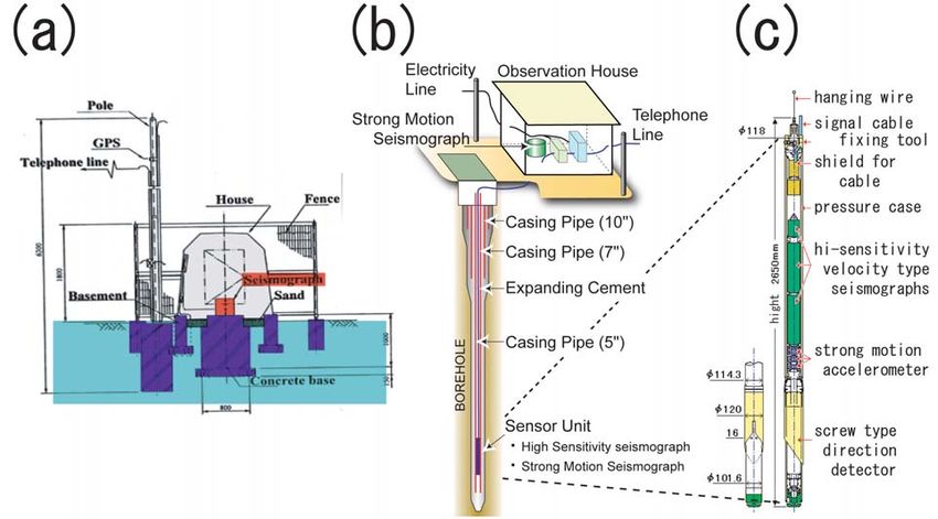
LOCATION OF STATIONS AND INSTRUMENTATION

K-NET and KiK-net consist of 1030 and 669 stations, respectively, and uniformly cover almost all
Japan (Fig. 1). Most K-NET stations (Fig. 2) are constructed on the grounds of a public facility such
as the public office of a municipal government, fire station, school or park and the sensors are installed
only on the free surface. This means that the K-NET sites are located near areas where human
activity takes place. In many cases, K-NET stations are located on type D (180 m/s < Vs < 360 m/s)
or type E (Vs < 180 m/s) soil as defined by the National Earthquake Hazards Reduction Program
(NEHRP; e.g. BSSC, 1997). While the K-NET stations were mainly constructed on sedimentary
sites, some of the KiK-net stations (Fig. 2) are located on weathered rock or on thinner sediment (C:
360 m/s < vs < 760 m/s). On average, site conditions of KiK-net are harder than those of K-NET.
KiK-net differs from the K-NET in that a pair of strong-motion sensors is installed at each station. One
is installed on the ground surface just above the borehole and the other is located at the bottom of the
borehole. The horizontal distance of these two sensors is a few meters in most cases. Records from
the pair of seismographs enable us to quantitatively evaluate the site effects at each station together
with the site information from downhole logging data. At most sites, downhole logging was carried
out on the occasion of the boring and the velocity profiles and soil conditions are available on the
Internet.
     Table 1 shows the distribution of the KiK-net borehole-depth. The borehole was design so that it
penetrates the sediment and reaches a type A (Vs < 1500 m/s) or type B (760 < Vs < 1500 m/s) rock as
defined by NEHRP. The depth of most boreholes is between 100 m to 200 m. At stations in urban
areas, which are located on thick sediment within large plains, such as the Kanto plain or Osaka basin,

          Fig. 3. Total characteristics of the instrument used for the K-NET and
          KiK-net.    (a) and (b) show the amplitude and phase characteristics,
          respectively. The cut-off frequency of the filer is 30 Hz.

                                                  - 68 -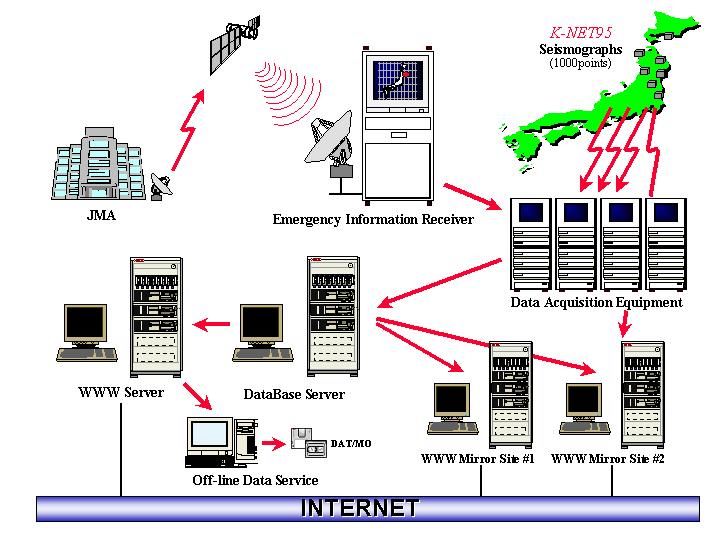
deeper boreholes are constructed and 21 of them are deeper than 1000 m (Table 2).
      Instrumentation used for the K-NET and KiK-net is basically the same. The sensor being used
is a V403 or V404 tri-axial force-balance accelerometer with a natural frequency of 450 Hz and a
damping factor of 0.707, which is manufactured by the Akashi Corporation. The typical sensor gain is
3 V/g (0.306 V/m/s^2). The data loggers used, K-NET95 (K-NET) and SMAC-MDK (KiK-net),
which are also manufactured by the Akashi Corporation, have a 24-bit A/D (effective resolution is at
least 18-bit) converter and a maximum measurable acceleration of 2000 gals (cm/s^2). Waveforms
are recorded with a sampling rate of 100 Hz for the K-NET and 200 Hz for the KiK-net. Figure 3
illustrates the amplitude and phase response of the transfer function of the total system.
      Ground motion is stored only if the ground motion satisfies the pre-set trigger condition. The
event trigger system of the data recorder is controlled using the signals on the surface (K-NET) or
downhole seismometer signals (KiK-net). Typically, event recording starts at a threshold level of 2
gals (K-NET) or 0.2-0.4 gals (KiK-net), and ends with a 30 seconds continuous signal of 2 gals or
lower (K-NET) or 0.1 gals or lower (K-NET). A minimum recording length of 120 seconds is assured
which includes the 15 seconds pre-trigger data. K-NET95 has 8 MB of memory, which can store a
total of about 2.5 hours of three component data digitized at a sampling frequency of 100 Hz, and
SMAC-MDK has 85 MB of memory that corresponds to about 6.5 hours for 200 Hz of six component
data. About 10% of this memory is reserved for large earthquakes. When the 90% memory area
used for normal earthquake activity becomes full, ground motion that exceeds a certain threshold,
typically 100 gals (K-NET) or 20 gals (KiK-net), is recorded in this reserved memory. The internal
clock used for the recording system (1 ppm precision) is automatically calibrated by a GPS signal
every hour on the hour with an accuracy of 5 m seconds.
      The orientation of horizontal components of downhole seismographs used in the KiK-net have
some uncertainty due to difficulties during installation. Orientations are estimated by evaluating
correlation of teleseismic waveform data (Shiomi et al., 2003). Sensor orientations may change
every time the sensor is re-installed for maintenance or some other reason. The updated orientations
are also available through the Internet.

              Fig.4 The flow of K-NET data release.

                                               - 69 -
DATA COLLECTION AND PUBLICATION
The NIED Data Management Center (DMC) located at Tsukuba unifies all observed stations through
public telephone lines (Fig. 4). When an earthquake occurs, the JMA (Japan Meteorological Agency)
immediately determines the source parameters (location and magnitude) and distributes them through
weather satellites. Dial-up operation for the collection of waveform data is triggered when this
information is received. The areas where the recorders are expected to be triggered are estimated
from the depth and magnitude of the earthquake and the dial-up operations are automatically started.
All digital data collected from earthquakes with a JMA magnitude of more than 3 are manually
checked and provided on our website as soon as possible (typically, within a few hours to one day
after the earthquake) in the K-NET format. Users can select specific events or stations with a
combination of key parameters to download. Station maps, individual waveforms, and a paste-up of
waveforms can also be browsed, selected and downloaded. All data and information is also available
through an FTP site (www.k-net.bosai.go.jp for the K-NET and ftp.kik.bosai.go.jp for the KiK-net).
EXAMPLE OF DATA
We would like to introduce two large earthquakes as examples of typical data recorded by our
Fig. 5. Waveforms observed
on the surface and the bottom
of the 100 m deep borehole at
Hino station (TTRH02) at 8
km away from epicenter.
The maximum acceleration
was 1135 gals (vector
composition of three
components) and the JMA
seismic intensity was 6.6.
- 70 -Fig. 6. The distribution of PGA associated with the 2000 Western Tottori earthquake (a) at
100-200 m depth and (b) on the ground surface. On (a), the moment tenser solution of
F-net is shown. On (b), the aftershock distribution in the period, 13:30-23:59JST, October
6, is overlaid.
networks. One is the 2000 Western Tottori earthquake of 13:30 (JST), October 6, 2000 (Mw 6.6),
that was the first inland earthquake of the over-M6.5-class after K-NET and KiK-net were deployed all
over Japan. The other earthquake is the 2003 Tokachi-oki earthquake (Mw 8.0), which occurred in
the southern Kuril subduction zone on September 26, 2003, 4:50 (JST), that was the first M8-class
interplate earthquake around Japan after the beginning of the modern digital strong motion
seismograph network was established.
The 2000 Western Tottori earthquake
The 2000 Western Tottori earthquake (2000/10/06, 13:30 JST, 35.275N, 133.348E, 11 km; JMA, Mw
6.6) triggered 303 K-NET stations and 220 KiK-net stations. The nearest station, TTRH02 (Hino;
epicentral distance of 8km, Fig. 5) recorded peak vector accelerations (vector summation of three
components) of 1135 gals on the ground surface and 653 gals at the bottom of the 100 m borehole.
This was the first JMA seismic intensity VII waveform recorded by our network. The waveforms
were recorded at 31 stations within 100 km from the epicenter and 10 of them were within 50km.
Figure 6 shows the distribution of the peak vector accelerations around the source region, where
(a) is the one at the bottom of the boreholes (100-200 m depth) of KiK-net, and (b) is the one on the
ground surface of K-NET and KiK-net. Aftershock distribution in the period, 13:30-23:59JST,
October 6, is overlaid in Figure 6(b). Compared to the simple elliptic pattern at the well bottom, the
pattern on the surface is rather complex reflecting the variety of soil conditions. The similar
tendencies in the distribution differences of peak accelerations were also observed for many
earthquakes. The difference of the PGA distributions between downhole and surface records enables
us quantitative evaluation of the site effects.
The 2003 Tokachi-oki earthquake
The 2003 Tokachi-oki earthquake, occurred in the southern Kuril subduction zone on the 26th of
September 2003, 4:50 JST (41.7797.N, 144.0795.E, 42 km; JMA, Mw 8.0). This earthquake was
- 71 -Fig. 7. Comparison between observed peak ground motions and an empirical
attenuation relationship (dashed lines). Left: PGA at the surface. Right: PGV
on the engineering bedrock (Vs = 600 m/s), with the correction following by Si
and Midorikawa (1999). Dotted lines indicate the standard deviations for the
empirical relationships.
the first M8-class interplate earthquake around Japan after the dense and modern strong motion
seismograph network was established. The ground motions due to the event were observed over a
wide region covering 655 K-NET and KiK-net stations. The overall features of observed PGA (peak
ground acceleration) and PGV (peak ground velocity) can be explained by empirical attenuation
relationships (Fig. 7). A maximum PGA of 988 gals was observed at station HKD100 and
amplitudes greater than 200 gals were observed over a wide area covering eastern Hokkaido.
Large oil tanks at Tomakomai, 200 km eastern away from the epicenter, located in the Yufutsu
plane were seriously damaged by sloshing caused by the long duration of long period waves. The
main cause of this phenomenon was the large plane structure with very thick sediment. The PGV
distribution (Fig. 8) shows that the PGV at the Yufutsu plane was larger than its surroundings. Last
year, NIED started to routinely analyze the source process for large earthquakes (Fig. 8) by waveform
inversion under the vision that accumulation of rupture models is very useful in understanding the
fault mechanism and also in evaluating the strong motion.
DISCUSSION AND CONCLUSIONS
It is important in disaster mitigation to obtain various types of large-amplitude records and investigate
the relationships between ground motion and damage. The 1995 Hyogoken-Nanbu earthquake made
us realize again that there is a possibility that large earthquakes can occur anywhere in Japan, due to
the great number of active faults all over the country and plates surrounding the Japanese Islands. To
record these unpredictable strong motions as accurately as possible, NIED has constructed the
permanent dense strong motion network, K-NET and KiK-net. Eight years have passed since K-NET
went into operation, and during this time, it has provided large quantities of strong motion data
including near fault ground motion of inland earthquakes such as the 2000 Western Tottori earthquake,
and large interplate earthquakes such as the 2003 Tokachi-oki earthquake. Table 3 shows the records
- 72 -Fig. 8. Distribution of PGV and estimated total slip distribution by NIED. PGV's
were obtained by integrating observed accelerations by K-NET and KiK-net. Star
indicates the hypocenter. Slip distribution was estimated by a multi-time window
analysis using K-NET and KiK-net data for a bandwidth of 5-50 seconds. (Honda et
al., 2004).
that exceeded 900 gals. The dense network showed that the large accelerations were not accidental
phenomena and PGA of over 1g (980 gal) is not a very rare occurrence, although they were observed
within a spatially limited area. When observations are sparse, it is difficult to judge whether large
ground motions are caused just by local conditions such as topography effects or soft soil like bank or
not. We believe that it is necessary to maintain the network to record important strong motion data
for expected future large earthquake.
Recently, the instruments at 443 K-NET stations, which indicated by blue circles in Fig. 1(a) have
been replaced with a new system, the K-NET02. This new system has several advantages over the
current system, the K-NET95. (1) K-NET02 has been officially approved as a seismic intensity
meter by the JMA. Seismic intensity is automatically sent to JMA and DMC at NIED within two
minutes after being triggered. This information will contribute directly to the decision and actions of
administration. (2) K-NET02 will automatically call the DMC at NIED several seconds after being
triggered and transmit waveform data even while recording. This function not only reduces much of
the time for data collection but also helps in avoiding any overcrowding of telephone lines. The only
practical countermeasure for overcrowding is to connect to the line before it becomes crowded. (3)
The signal to noise ratio of K-NET02 in the long-period band has been improved by a factor of ten
compare with the K-NET95. This will improve the accuracy of data analysis in the long period
band such as waveform inversion analysis of source processes. NIED is now planning to replace the
rest of the K-NET system in the near future because we believe that the new system will better
contribute to both disaster mitigation and the acquisition of fundamental data in the field of strong
motion seismology.
- 73 -Table 3. Over 900 gals ground motions recorded by K-NET and KiK-net.
ACKNOWLEDGMENTS
Comments by two anonymous reviewers were useful in improving the manuscript. Some figures
were drawn by GMT Ver.3.3.4 (Wessel and Smith, 1995).
REFERENCES
Aoi, S., Obara, K., Hori, S., Kasahara, K. and Okada, Y. (2000). “New strong-motion observation
network: KiK-net.” EOS. Trans. Am. Geophys. Union, Vol. 81, F863.
BSSC (Building Seismic Safety Council) (1997). NEHRP recommended provisions for seismic
regulations for new buildings and other structures, Part 1: Provisions (FEMA 302), Building
Seismic Safety Council, Washington, D.C., USA., 33.
Fukuyama, E., Ishida, M., Hori, S., Sekiguchi, S. and Watada, S. (1996). “Broadband seismic
observation conducted under the FREESIA Project.” Rep. Nat'l Res. Inst. Earth Sci. Dsas. Prev.,
Vol. 57, 23-31.
Geographical Survey Institute (1998). “Crustal deformation of Japan detected GEONET.”
http://mekira.gsi.go.jp/ENGLISH/index.html.
Honda, R., Aoi, S., Morikawa, N., Sekiguchi, H., Kunugi, T. and Fujiwara, H. (2004). “Ground motion
and rupture process of 2003 Tokachi-oki earthquake obtained from strong motion data of K-NET
and KiK-net.” Earth Planets Space, Vol. 56, 317-322.
Kinoshita, S. (1998). “Kyoshin Net (K-NET) .” Seism. Res. Lett., Vol. 69, 309-332.
Obara, K. (2002). “Hi-net: High sensitivity seismograph network, Japan.“, Lecture Notes in Earth
Sciences, Vol. 98, 79-87.
Okada, Y., Kasahara, K., Hori, S., Obara, K., Sekiguchi, S., Fujiwara, H. and Yamamoto, A. (2004).
“Recent progress of seismic observation network in Japan --- Hi-net, F-net, K-NET and KiK-net
---.” submitted to Earth Planets Space.
Shiomi, K., Obara, K., Aoi, S. and Kasahara, K. (2003). “Estimation on the azimuth of the Hi-net and
KiK-net borehole seismometers.” Zisin2, Vol. 56-1, 99-110.
Si, H. and Midorikawa, S. (1999). “New attenuation relationships for peak ground acceleration and
velocity considering effects of fault type and site condition.” (in Japanese) J. Struct. Constr. Eng.,
AIJ, Vol. 523, 63-70.
Wessel, P. and Smith, W. H. F. (1995). “New version of the Generic Mapping Tools released.” EOS
Trans. AGU, Vol. 76, 329.
(Submitted: May 6, 2004)
(Accepted: June 22, 2004)
Copyright JAEE
- 74 -You can also read