STRATEGIC HOUSING DEVELOPMENT PLANNING APPLICATION SCHOOLS DEMAND AND CHILDCARE FACILITIES ASSESSMENT
←
→
Page content transcription
If your browser does not render page correctly, please read the page content below
LANDS AT BALSCADDEN
                        Schools Demand & Childcare Facilities Assessment

    STRATEGIC HOUSING DEVELOPMENT
              PLANNING APPLICATION
     SCHOOLS DEMAND AND CHILDCARE
               FACILITIES ASSESSMENT
FOR LANDS AT BALSCADDEN & FORMER BAILY COURT
                     HOTEL, HOWTH, CO.DUBLIN

                                                  CLIENT
                            Balscadden GP3 Limited

                                                    DATE
                                           March 2022

                                                                     1
LANDS AT BALSCADDEN
Schools Demand & Childcare Facilities Assessment

DOCUMENT CONTROL SHEET

Project No.         6880
Client:             Balscadden GP3 Limited
Project Name:       Lands at Balscadden
Report Name:        Schools Demand and Childcare Facilities Assessment
Document No.        RPSC05
Issue No.           02
Date:               21/03/22

This document has been issued and amended as follows:
 Issue     Status                                                  Date          Prepared     Checked
 01        Draft – for Strategic Housing Development Application   17 Feb 2022   HM           PB
 02        Final- for Strategic Housing Development Application    21 Mar 2022   HM           PB

     Brady Shipman Martin                                                              www.bradyshipmanmartin.com
     DUBLIN
     Mountpleasant Business Centre
     Ranelagh
     Dublin 6
     + 353 1 208 1900

     CORK
     Penrose Wharf Business Centre
     Penrose Wharf
     Cork
     +353 21 242 5620

     LIMERICK
     11 The Crescent
     Limerick
     +353 61 315 127

     mail@bradyshipmanmartin.com

 2
LANDS AT BALSCADDEN
                                                                                Schools Demand & Childcare Facilities Assessment

TABLE OF CONTENTS

1   INTRODUCTION ............................................................................................................. 4
    1.1     Background ...................................................................................................................................4
    1.2     Methodology ................................................................................................................................4

2   PROPOSED DEVELOPMENT ........................................................................................... 5
    2.1     Site Description.............................................................................................................................5
    2.2     Description of Development ........................................................................................................6
    2.3     Proposed Development ................................................................................................................7

3   PLANNING POLICY CONTEXT ......................................................................................... 7

4   DEMOGRAPHIC PROFILE OF THE STUDY AREA............................................................ 11
    4.1     Population Profile ...................................................................................................................... 11
    4.2     Age Profile ................................................................................................................................. 12
    4.3     Average Household Size ............................................................................................................ 13
    4.4     Population of The Proposed Development ............................................................................... 15

5   EXISTING AND PROPOSED CHILDCARE PROVISION ..................................................... 15
    5.1     Existing Childcare Provision ....................................................................................................... 15
    5.2     Proposed Childcare Provision.................................................................................................... 20

6   ESTIMATED CHILDCARE DEMAND AND ANALYSIS ...................................................... 20
    6.1     Early Years Sector Profile Report 2019/2020 ............................................................................ 20
    6.2     Childcare Facilities: Guidelines for Planning Authorities (2001) ............................................... 21
    6.3     Estimated Childcare Demand Summary. .................................................................................. 21

7   EXISTING AND PROPOSED SCHOOL PROVISION .......................................................... 22
    7.1     Existing Primary School Provision.............................................................................................. 22
    7.2     Proposed Primary School Provision .......................................................................................... 25
    7.3     Existing Secondary School Provision ......................................................................................... 25
    7.4     Proposed Secondary School Provision ...................................................................................... 28

8   ESTIMATED SCHOOL DEMAND AND ANALYSIS ........................................................... 28
    8.1     Estimated Primary School Demand ........................................................................................... 28
    8.2     Estimated Secondary School Demand ...................................................................................... 29
    8.3     Estimated School Demand Summary ........................................................................................ 30

9   CONCLUSION ............................................................................................................... 31

                                                                                                                                                       3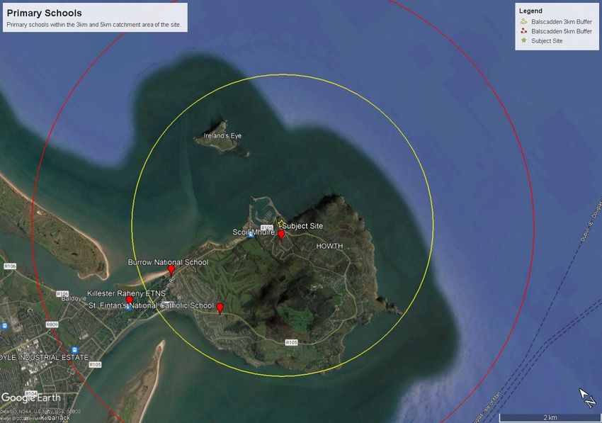
LANDS AT BALSCADDEN
Schools Demand & Childcare Facilities Assessment

1     INTRODUCTION

The purpose of this Report is to assess the provision and need for childcare facilities and school
places in the area close to the subject application site of c.1.43ha (hereafter called ‘the site’). The
site comprises lands at Balscadden Road, south of the Martello Tower, and at the Former Baily
Court Hotel, Main Street, Howth, Co. Dublin.

This Report has been prepared in response to the requirement of planning policy including the
Provision of Schools and the Planning System; the Childcare Facilities Guidelines (2001); Fingal
County Development Plan 2017-2023; Sustainable Residential Development in Urban Areas (2009);
and The Sustainable Urban Housing: Design Standards for New Apartments Guidelines for Planning
Authorities (2020).

This Report should be read in conjunction with the other documentation (reports and drawings)
accompanying this Strategic Housing Development (SHD) application.

1.1    Background

Childcare
The provision of childcare facilities is an important factor for economic and social wellbeing. The
Childcare Facilities Guidelines for Planning Authorities, 2001 (Childcare Facilities Guidelines 2001)
states that access to quality childcare services contributes to the social, emotional, and educational
development of children with clear economic benefits from the provision of childcare. Quality
childcare can benefit children, their parents, employers, and communities in general.
The Fingal County Childcare Committee supports a childcare infrastructure of 364 early childhood
facilities that collectively employ in excess of 3,000 staff. The requirement to assess the need for
childcare facilities is set out in the Fingal County Development Plan 2017-2023 and the Childcare
Facilities Guidelines (2001).

Schools
This Report has been prepared in response to the requirements of Fingal County Council who will
consider future school developments having regard to specific requirements of the Department of
Education and Skills and guidance set out within The Provision of Schools and the Planning System,
A Code of Practice for Planning Authorities, the Department of Education and Science, and the
Department of the Environment, Heritage and Local Government, 2008 (The Provision of Schools
Guidelines, 2008). New schools shall be developed in areas where new/additional schools are
required as identified by the Department, referred to as School Planning Areas, and/or within
existing school/ education sites.

1.2    Methodology

Given the location of the site located and its proximity to the sea, a 5km catchment area has been
selected in order to cover a fair representation of land. A 3km catchment area has also been

 4
LANDS AT BALSCADDEN
                                                        Schools Demand & Childcare Facilities Assessment

selected to show refined results and illustrate those childcare facilities and schools closest to the
site.

This report is primarily a desktop-based study, using freely available data and information services
to assess the proposed development and its future population, in the context of nearby existing
childcare facilities and schools.

The unit numbers and mix used in this report reflects the future composition of the development’s
population. This information was used to indicate potential childcare demand and school places
arising from the proposed development, in tandem with the composition of nearby developments,
to reflect future demand in the area.

Information in relation to the existing childcare providers was obtained from TUSLA’s register of
early years published in December 2020.

Enrolment data was obtained from the most up to date Department of Education and Skills
2021/2022 statistics available on www.gov.ie. Data in relation to the future provision of schools in
the area was obtained from the Department of Education and Skills website.

Population data was also obtained from the Central Statistics Office (CSO, 2016) and used to create
a demographic profile of the immediate area.

2     PROPOSED DEVELOPMENT

2.1    Site Description
The site is located in Howth, County Dublin approximately 16 km northeast of the city centre. While
the site is on the edge of the urban extent of Dublin City it is within the administrative area of Fingal
County Council and is designated as an area for the future consolidation of Dublin City.

The site is located between the western side of Baldscadden Road and lies south of the Martello
Tower which is a protected structure. The Martello Tower looks down over the site. The site is
bounded by Balscadden Road and Balscadden Bay to the east. The site is bounded to the south by
Asgard Park and on the west the site includes the former Baily Court Hotel which fronts onto the
Main Street and Abbey Street.

The site has 2 no. road frontages from the Balscadden Road and Main Street. Balscadden Road rises
steeply from the Harbour Road to the north and follows a route around the base of the mount to
the Martello Tower to pass Asgard apartments which lie on the eastern side of the road before
reaching the site. Balscadden Road is a one-way road that runs from the east pier of Howth
Harbour and forms a T-Junction with Kilrock Road. There is a narrow footpath on the eastern bay
side of the road and double yellow line parking restriction are on both sides of the road. The road
is used by vehicles and pedestrians to access the cliff walk to Howth Head and the Howth SAAO,
which is a popular tourist destination in Fingal County.

                                                                                                      5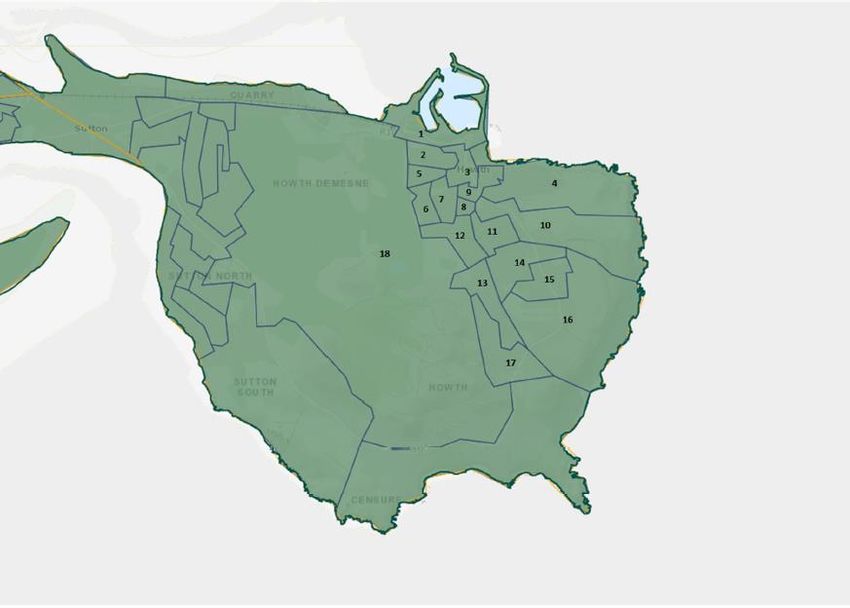
LANDS AT BALSCADDEN
Schools Demand & Childcare Facilities Assessment

2.2    Description of Development
The proposed development relates to lands located to the south of the Martello Tower on
Balscadden Road & the former Baily Court Hotel, Main Street, Howth, County Dublin. The
development will consist of the demolition of existing structures on the proposed site including the
disused sports building and the former Baily Court Hotel buildings and the construction of a
residential development set out in 4 no. residential blocks, ranging in height from 2 to 5 storeys to
accommodate 180 no. apartments with associated internal residential tenant amenity and external
courtyards and roof terraces, 1 no. retail unit and 2 no. café/retail units. The site will accommodate
car parking spaces at basement level and bicycle parking spaces at basement and surface level.
Landscaping will include new linear plaza which will create a new pedestrian link between Main St
and Balscadden Rd to include the creation of an additional 2 no. new public plazas and also
maintains and upgrades the pedestrian link from Abbey Street to Balscadden Road below the
Martello Tower. Please see the accompanying Statutory Notices for a more detailed description.

Figure 2-1: Subject Site in the Urban Context (Source: Google Maps with BSM overlay in Red, 2022).

 6
LANDS AT BALSCADDEN
                                                     Schools Demand & Childcare Facilities Assessment

2.3      Proposed Development
The proposed development comprises approximately 180 no. units. The following table outlines
the unit mix:
 Size                               Apartments
 Studios                                 4
 1 bed units                             62
 2 Bed Units                             89
 3 Bed Units                             25
 4 bed units                             -
 Total                                   180
 Excluding 1 bed units                   114
 and studios

3     PLANNING POLICY CONTEXT

3.1 Project Ireland 2040 – National Planning Framework
The National Planning Framework 2040 (NPF 2040) is the national framework to guide
development through national objectives and key principles. The NPF 2040 is a development
strategy which is key to shaping national, regional and local spatial development in economic,
environmental, and social terms until 2040.

The NPF 2040 recognises the importance of the provision of childcare facilities and schools for
future growth of the country stating that “the continued provision and enhancement of facilities
and amenities for childcare and young people such as childcare, schools, playgrounds, parks and
sportsgrounds, remains necessary and will need to be maintained at similar levels for the
foreseeable thereafter”.

The NPF 2040 sets out National Policy Objectives (NPOs) in order to deliver the overall vision
outlined in the framework. The NPO in relation to childcare services and schools, both primary and
secondary, is set out below:

NPO 31: “Prioritise the alignment of targeted and planned population and employment growth
within investment in the provision of childcare facilities and new and refurbished schools on well
located sites within or close to existing built-up areas, that meet the diverse needs of local
populations.”

3.2      Eastern & Midland Regional Assembly Regional Spatial & Economic Strategy 2019-
         2031
The Eastern & Midland Regional Assembly Regional Spatial & Economic Strategy 2019-2031 (the
RSES) is a strategic plan and investment framework to assist the future growth and regional
planning and economic development throughout the eastern and midland region.

                                                                                                  7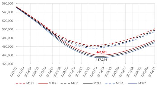
LANDS AT BALSCADDEN
Schools Demand & Childcare Facilities Assessment

Regarding childcare facilities and schools, the RSES states that Local Authorities should consider
demographic trends and patterns when carrying out an assessment of the need for social
infrastructure, the impact of factors such as an ageing population and the resulting demand for
facilities. There are a number of Regional Policy Objectives (RPOs) that support the provision of
childcare facilities and schools which are set out below:

RPO 9.20: “Support investment in the sustainable development of the Region’s childcare services as
an integral part of regional infrastructure to include… quality and supply of sufficient childcare
places”.

RPO 9.21: “In areas where significant new housing is proposed, an assessment of need regarding
schools’ provision should be carried out in collaboration with the Department of Education and Skills
and the statutory plans shall designate new school sites at accessible, pedestrian, cycle and public
transport friendly locations”.

3.3   Childcare Facilities: Guidelines for Planning Authorities (2001)
The Childcare Facilities: Guidelines for Planning Authorities (2001) (Childcare Facilities Guidelines
2001) aims to provide guidance on sustainable childcare facilities to ensure a consistent approach
throughout the country.

The Childcare Facilities Guidelines 2001 state that in larger new housing developments 1 no.
childcare facility should be provided per every 75 no dwellings:

“Planning authorities should require the provision of at least one childcare facility for new housing
areas unless there are significant reasons to the contrary for example, development consisting of
single bed apartments or where there are adequate childcare facilities in adjoining developments (our
emphasis). For new housing areas, an average of one childcare facilities for each 75 dwellings
would be appropriate.”

The Childcare Facilities Guidelines 2001 further note that the “threshold for provision should be
established having regard to the existing geographical distribution of childcare facilities and the
emerging demographic profile of area”.

3.4   Action Plan for Education 2021-2023
The Action Plan for Education 2021-2023 is a high-level plan that aims to support the provision of
high-quality education, deliver appropriate systems and infrastructure and ensure equity of
opportunity in education for all students.

The Action Plan for Education 2021-2023 highlights the importance of the role of schools and
education settings play in creating a sustainable community. It further pledges to work with the
Department of Housing and Local Government and will “continue to cooperate with regard to
school infrastructure planning processes.”

 8
LANDS AT BALSCADDEN
                                                      Schools Demand & Childcare Facilities Assessment

3.5        The Provision of Schools and the Planning System: A Code of Practice (2008)
The Provision of Schools and the Planning System: A Code of Practice 2008 (Provision for School
Guidelines 2008) sets out several initiatives to promote proper planning and sustainable
development with regard to the effective co-ordination of development and school provision.
The document was designed to facilitate the provision of schools and related infrastructure
alongside mechanisms for new schools through the following actions:

      1.    Forecasting Future Education Demand
      2.    Planning for New Schools through Local Authority Development Plans
      3.    Location of Schools – Planning Considerations
      4.    Site Development Standards
      5.    School Development Proposals and the Development Management Process
      6.    school Site Identification and Acquisition

In relation to Development Management Guidelines, The Provision for School Guidelines 2008
require planning authorities to:

“Take due account of the requirements of section 4.4 of the draft planning guidelines on Sustainable
Residential Development in Urban Areas, which requires planning applications for major housing
proposals to be accompanied by assessments of the capacity of local schools to accommodate the
proposed development.”

3.6        Guideline for Planning Authorities on Sustainable Residential Development in Urban
           Areas (2009)
The Guidelines for Planning Authorities on Sustainable Residential Development in Urban Areas
(2009) (Sustainable Residential Development Guidelines) are relevant to school provision. The
Sustainable residential Development Guidelines state:

“Planning applications for 200+ dwelling units should be accompanied by a report identifying the
demand for school places likely to be generated by the proposal and the capacity of existing schools
in the vicinity to cater for such demand. In very large-scale residential developments (say, 800+),
planning authorities must consider whether there is a need to link the phased completion of
dwellings with the provision of new school facilities.”

Whilst the proposed development consists of 180 no. units, this report has been prepared as good
practice and responds to the requirements of Section 4.4 of the Sustainable Residential
Development Guidelines.

3.7        Sustainable Urban Housing: Design Standards for New Apartments (2020)

The Sustainable Urban Housing: Design Standards for New Apartments (2020) (Design Standards
for New Apartments) reiterates the standard of childcare facilities that should be provided within
the Childcare Guidelines but emphasises how sites should be considered on individual merit:

                                                                                                   9
LANDS AT BALSCADDEN
Schools Demand & Childcare Facilities Assessment
“Notwithstanding the Planning Guidelines for Childcare Facilities (2001), in respect of which a
review is to be progressed, and which recommends the provision of one child-care facility
(equivalent to a minimum of 20 child places) for every 75 dwelling units, the threshold for provision
of any such facilities in apartment schemes should be established having regard to the scale and
unit mix of the proposed development and the existing geographical distribution of childcare
facilities and the emerging demographic profile of the area. One-bedroom or studio type apartments
should not generally be considered to contribute to a requirement for any childcare provision and
subject to location, this may also apply in part or whole, to units with two or more bedrooms”
(emphasis added).
3.8 Better Outcomes, Brighter Futures – The national policy framework for children and
young people 2014 – 2020 (DCYA, 2014).
Better Outcomes, Brighter Futures represents the first overarching national children’s policy
framework comprehending the age ranges spanning children and young people (0 – 24 years). It
adopts a whole Government approach and will be underpinned by a number of constituent
strategies in the areas of early years, youth and participation.
3.9 Fingal County Development Plan 2017-2023
The site is in the administrative area of Fingal County Council which is governed by the Fingal
Development Plan 2017-2023 (Development Plan). The Development Plan sets out the Council’s
proposed policies and objectives for development of the County between the plan period of 2017-
2023.
Regarding childcare, schools and education facilities, the Development Plan states the importance
of childcare and education facilities in accessible locations:
“Appropriate accessible locations is important as they contribute positively to an enhanced quality
of life.”
Childcare Facilities
Regarding childcare facilities the Development Plan sets out the following considerations:
Objective PM74 “Encourage the provision of childcare facilities in appropriate locations, including
residential areas, town and local centres, areas of employment and areas close to
public transport nodes.”
Objective PM75 “Ensure that childcare facilities are accommodated in appropriate premises,
suitably located and with sufficient open space in accordance with the Childcare
(Pre-School) Services) (No. 2) Regulations 2006.”
Objective PM76 “Require as part of planning applications for new residential and commercial
developments that provision be made for appropriate purpose-built childcare
facilities where such facilities are deemed necessary by the Planning Authority.”
10LANDS AT BALSCADDEN
Schools Demand & Childcare Facilities Assessment
Schools
Fingal County Council will consider school developments having regard to specific requirements of
the Department of Education and Skills and guidance set out within ‘The Provision of Schools and
the Planning System, A Code of Practice for Planning Authorities, the Department of Education and
Science, and the Department of the Environment, Heritage and Local Government, 2008’.
Fingal County Council aims to work closely with the Department of Education and Skills under the
Memorandum of Understanding for the acquisition of school sites to identify and procure school
sites where a shortfall in school places is identified.
In September 2015, a €3.8 billion capital plan was announced by the Government. This funding is
for investment in primary, secondary and third level education facilities, combining the upgrade
and extension of existing educational infrastructure and the provision of new buildings over the
period 2016 – 2021. The Development Plan aims to provide for the provision of schools through a
series of objectives including:
Objective PM78: “Reserve individual sites for primary and secondary schools in consultation with
the Department of Education and Skills, based on current population using the
most up to date statistical data, anticipated additional growth based on
residentially zoned land, taking into consideration the timelines of planning and
constructing new school places, and in line with access to public transport.”
Objective PM83: “Promote and encourage the use of multiple usage of school buildings so that
school facilities are also available for use by the local community after school
hours.”
4 DEMOGRAPHIC PROFILE OF THE STUDY AREA
It is considered that a total catchment area of 5km is a fair representation of accessible childcare
facilities and schools given the location of the site. As noted above, a 3km buffer is also shown to
illustrate those childcare facilities and schools closest to the site in which the future population can
avail of.
As mentioned in Section 1.3, the demographic profile is based on population data from the Census
2016. The site is located within the administrative area of Fingal and within Howth Electoral
Division (ED) (CSO Ref. 04024) which forms the main demographic profile of the area surrounding
the site.
4.1 Population Profile
Between 2011 and 2016 the population of Fingal grew at a faster rate (8.1%) in comparison to the
State at 3.8% and Dublin at 5.1%. However, Howth ED is increasing at a slower rate with population
increasing by 0.8% between 2006 and 2011 and 0.5% between 2011 and 2016 as shown in Table
4-1.
11LANDS AT BALSCADDEN
Schools Demand & Childcare Facilities Assessment
Area 2006 2011 2006-2011 2016 2011-2016
population population change (%) population change (%)
State 4,239,848 4,588,252 8.2% 4,761,865 3.8%
Dublin 506,211 527,612 4.2% 554,554 5.1%
Fingal 239,992 273,991 14.1% 296,020 8.1%
Howth ED 8,196 8,261 0.8% 8,294 0.5%
Table 4-1: Population growth within The State, Fingal and Howth ED between 2006-2016 (Source: CSO
2006,2011,2016).
4.2 Age Profile
In order to assess the proportion of the population which require childcare services and school
provision, the age profile of Fingal and Howth between 2011 and 2016 was reviewed as shown
below in Table 4-2.
Age Group Fingal 2011 Fingal 2016 % Howth ED Howth ED %
Population Population Change 2011 2016 Change
Population Population
Pre-school (0-4 26,708 24,899 -6.8% 457 401 -12.2%
years)
Primary School 33,076 39,349 18.9% 744 803 7.9%
(5-12 years)
Secondary 19,054 22,892 20.1% 602 630 4.6%
School (13-18
years)
Young Adults 20,188 18,980 -6.0% 594 513 -13.6%
(19-24 years)
Adults (25-64) 155,104 162,865 5.0% 4,051 3,904 -3.6%
Older Adults 19,861 27,035 36.1% 1,808 2,043 13.0%
(65+)
Total: 273,991 296,082 8.1% 8,256 8,295 0.5%
Table 4-2: Age Profile of Fingal and Howth ED between 2011 and 2016 (Source: CSO 2011 & 2016).
CSO Census data from 2011 and 2016 indicated that that the pre-school population (typically 0-4
years) has decreased in both Fingal (-6.8%) and Howth ED (-12.2%) respectively. This follows the
trend of the State where the population of pre-school children decreased by 7% between 2011 and
2016.
The 0–4-year-old age cohort of Howth ED accounted for an acute proportion of the overall
population in 2016 at 4.8%. The pre-school age profile of Fingal and Howth ED is shown below in
Table 4-3.
12LANDS AT BALSCADDEN
Schools Demand & Childcare Facilities Assessment
Area 0 years 1 years 2 years 3 years 4 years Total % of total
old old old old old population
Fingal 4,455 4,768 5,056 5,132 5,488 24,889 8.4%
Howth ED 57 99 63 86 96 401 4.8%
Table 4-3: 0–4-year-old breakdown in Fingal and Howth ED (Source: CSO 2011 & 2016)
According to the CSO, this downward trend of the 0–4-year-old age cohort is primarily due to a fall
in births since 2009.
However, there was a large increase in the population of those within primary school age (typically
5-12 years) and of secondary school age children (typically 13-18 years) within Fingal and Howth
between 2011 and 2016. The primary school population in Fingal increased by 18.9% between
2011 and 2016 whilst in Howth ED it increased by 7.9%.
According to the Census 2016, within Howth ED there are 803 no. children of primary school age,
which is an increase of 7.9% from 744 no. children in 2011. The primary school age cohort within
Howth ED accounts for 10% of the total population.
Likewise, those of secondary school age increased by 4.6% from 2011 to 2016 with 602 no. children
to 630 no. children. Those of secondary school age account for 7.6% of Howth ED’s total
population.
4.3 Average Household Size
The average household size is calculated using the total number of houses divided by the total
number of people within the households. Table 4-4 below shows the average household size in
Fingal and Howth ED. Howth ED has a considerably smaller household size of 2.68 people in
comparison to Fingal with approximately 3.2 people per household.
The Census 2016 confirms that the average number of children per family nationally is 1.38.
Area Households Persons Average Household Size
Fingal 96,812 292,989 3.02
Howth ED 3,069 8,248 2.68
Table 4-4: Average Household Size in Fingal and Howth ED
To refine the results further, small area populations (SAPs) within the immediate area of the site
have been analysed showing a total of 1,579 no. households with a population of 4,501 no. people.
13LANDS AT BALSCADDEN
Schools Demand & Childcare Facilities Assessment
Figure 4-1: Satellite view of Small Area Populations used to create population profile of proposed development
(Source: CSO 2016).
Figure 4-1 illustrates the SAPs within the immediate area of the site. Table 4-6 shows the average
household size of those living in apartments within the 18 no. SAPs which equates to 2.33 people.
This is slightly lower than the overall average household size in Howth ED (2.68).
Apartments/Flat
SAP REF Households Persons
267095022 59 156
267095015 1 1
267095028 28 60
276095031 7 10
276095012 1 1
267095013 0 0
267095014 2 9
267095029 0 0
267095030 5 9
267095033 27 83
267095032 0 0
267095016 1 1
267095024 2 3
267095025 15 26
267095026 4 7
14LANDS AT BALSCADDEN
Schools Demand & Childcare Facilities Assessment
267095027 1 2
267095023 1 1
267095005 10 14
Total 164 383
Average HH Size 2.33
Table 4-5: Average Household Size of SAPs in the Immediate Area (Source: CSO 2016).
4.4 Population of The Proposed Development
The proposed development is comprised of 180 no. units consisting of 4 no. studios, 62 no. 1-bed
units, 89 no. 2-bed units and 25 no. 3-bed units across 4 no. blocks (A-D) within a c.1.43ha site.
As noted above, the average household size for Fingal is 3.02 people and 2.68 people in Howth ED.
Refining the surrounding area through analysing the SAPs in the immediate area and the proposed
development type, the average household size for those living in apartments surrounding the
subject site is 2.33 people. Table 4-7 shows the envisaged population of the proposed development
applying the average household size from Fingal, Howth ED and the Immediate Area (SAPS).
Area Calculation Total
Fingal 180 (no. of units) X 3.02 (avg. HH size) 544 people
Howth ED 180 X (no. of units) X 2.68 (avg. HH size) 482 people
Immediate Area (SAPS) 180 (no. of units) X 2.33 (avg. HH size) 419 people
Table 4-6: The Population of the Proposed Development
Acknowledging the Howth ED population average household size of 2.68 no. people and the SAPs
average household size of 2.33 no. people, this would suggest a proposed population in the range
of 419-482 no. people resulting from the development.
For the purposes of this report, we will continue to assess the demand for childcare and school
provision with reference to the average household size of Howth ED (2.68) in order to provide a
fair representation for the purposes of childcare requirements.
5 EXISTING AND PROPOSED CHILDCARE PROVISION
As part of this report, we have surveyed the provision of Childcare Services in the area to provide
a summary of both existing and permitted childcare facilities in the vicinity.
5.1 Existing Childcare Provision
Figure 5-1 below outlines the number and distribution of childcare facilities within the area. Within
5km there are 12 no. childcare facilities in which 7 no. of the facilities fall within a 3km radius from
the site.
All childcare facilities are of varying scale and operational services as shown in the corresponding
table (Table 5-1), however 5 no. facilities are of larger scale with the capacity to accommodate
between 55 and 100 no. children per day. St Lawrence Child Day Centre is within closest proximity
to the site (c. 0.17km) and has capacity to accommodate for 45 no. children through full time and
sessional day care services.
15LANDS AT BALSCADDEN Schools Demand & Childcare Facilities Assessment The 12-no. childcare facilities within the 5km catchment area have a total capacity of 609 no. places with 345 no. of those places (56%) being within 3km. Given the relatively low population density of the surrounding neighbourhood there is a high number of childcare facilities in the area. 16
LANDS AT BALSCADDEN
                                                                                                                                 Schools Demand & Childcare Facilities Assessment

Figure 5-1: Overview of existing and permitted childcare services within a 5km radius from the site (Source: Google Maps 2021, Adapted by BSM 2022)

                                                                                                            17
LANDS AT BALSCADDEN
Schools Demand & Childcare Facilities Assessment
No. Childcare Facility Name Address Age Profile Service Type No. of Children can Distance from
be accommodated the Site (km)
1. St. Lawrence Child Day Methodist Church, St. 6 Months – 9 Years Full Time and Part Time 45 c. 0.17km
Care Centre Lawrence Road, Sessional
Howth
2. Fairyhill Playschool Howth Tucketts Lane, Howth 2-6 Years Sessional 20 c. 0.30km
Preschool Playgroup
Limited
3. Deerpark Montessori Deerpark 2-6 Years Sessional 22 c. 0.99km
School Montessori, St.
Mary’s Parish Hall,
Howth
4. Bracken Hill Nursey School Balkhill Road, Howth 2-6 years Sessional 55 c. 1.12km
5. The Cottage Montessori Howth Presbyterian 2-6 Years Sessional 22 c.1.51km
School Church Hall, 103
Howth Road, Howth
6. Little Rainbows (Sutton) The Old Convent, 1-6 Years Old Full Day and Part Time 96 c. 2.37km
Greenfield Road, Sessional
Dublin 13
7. Bumblebee School Ltd Westbury House, St, 0-6 Years Full Day Part Time Sessional 85 c. 2.56km
Fintan’s Road, Dublin
13
18LANDS AT BALSCADDEN
Schools Demand & Childcare Facilities Assessment
8. Rainbow Montessori Suttionans Rugby 2-6 Years Sessional 22 c. 3.44km
Sutton Club, Station Road,
Sutton, Dublin 13
9. Little People Creche and 33 Baldoyle Road, 0-6 Years Full Time and Part Time 34 c. 3.96km
Montessori Sutton, Dublin 13 Sessional
10. Mo’s Montessori Baldoyle Community 2-6 Years Sessional 32 c. 4.42km
Centre, Main Street,
Baldoyle, Dublin 13
11. Kids Klubs Childcare Unit 15, Bayside, 2-6 Years Full Day and Part Time 76 c. 4.99km
Limited Shopping Centre, Sessional
Sutton, Dublin 13
12. Anchor Childcare Centre Racecourse Shopping 2-6 Years Full Day 100 c. 5.00km
CLG Centre, Grange Road,
Baldoyle, Dublin 13
Total 609 no. childcare
places
Table 5-1: Overview of Childcare Services within the 3km and 5km Catchment Area from the Site
19Lands at Balscadden
Schools Demand and Childcare Facilities Assessment
5.2 Proposed Childcare Provision
As part of this report, we have also considered other significant permitted schemes within the surrounding
area which includes the provision of childcare facilities and will contribute to the overall quantum of childcare
places available. Details of the permitted childcare facilities are shown in Table 5-2.
Reg. Ref. Address No. of Children Size (sq.m) Pedestrian Avg Drive
can be Distance Time from
accommodated from Site Site (mins)
(km)
ABP-306102 Claremont SHD - Former 57 c. 236sq.m c. 1.2km c. 3 minutes
Techrete Site, Beshoff
Motors and Garden Centre,
Howth Road, Howth, Dublin
13
FCC F17A/0615 Santa Sabina SHD – Former 32 - c.3.7km c. 12
Sabina Dominican College minutes
and Convent Complex
Total 89 no. childcare
places
Table 5-2: Permitted Childcare Services in the Surrounding Area.
Within c. 2.5km of the site there are 2 no. permitted childcare facilities that will accommodate 89 no.
children.
6 ESTIMATED CHILDCARE DEMAND AND ANALYSIS
Including both existing and permitted childcare facilities, there are a total of c.698 no. childcare places within
5km of the site for future residents to avail of. This shows a surplus of childcare places within the catchment
area as there are more places than those of pre-school age in Howth ED with 401 no. 0-4 years olds as
recorded in the 2016 census.
6.1 Early Years Sector Profile Report 2019/2020
We contacted the Department of Children and Youth Affairs whom directed us to recently produced ‘Early
Years Sector Profile Report 2018/2019’ (December 2019) which provides detail in relation to childcare
capacity in the Country.
An updated report has since been released ‘Annual Early Years Sector Profile Report 2019/2020’ however it
does not contain information on enrolments, waiting lists and vacancies as this information was not available
due to the pause of childcare services in March 2020 and the incremental effects of Covid-19.
Therefore, based on the 2018/2019 report, capacity figures (enrolled and vacant places) within Fingal
increased by 0.7% with 11,599 in 2017/2018 to 11,678 in 2018/2019. Both enrolment and vacant places
within Fingal remain stable. Table 6-1 below shows capacity and vacancy numbers in Fingal in 2018/2019.
20Lands at Balscadden
Schools Demand and Childcare Facilities Assessment
County Enrolled Capacity Vacant places Vacancy rate
Dublin – Fingal 11,142 11,678 536 5%
Table 6-1: Enrolment and Vacancy numbers in Fingal (Source: DYCA/ Pobal 2019).
During 2018/2019 Fingal had 536 no. vacant places with a vacancy rate of 5%.
6.2 Childcare Facilities: Guidelines for Planning Authorities (2001)
As noted above in Section 3, the Childcare Facilities Guidelines 2001 recommend an average of one childcare
facility for each 75 no. dwellings stating:
“Planning authorities should require the provision of at least one childcare facility for new housing areas
unless there are significant reasons to the contrary for example, development consisting of single bed
apartments or where there are adequate childcare facilities in adjoining developments. For new housing areas,
an average of one childcare facilities for each 75 dwellings would be appropriate.”
Within the proposed development there are 4 no. studio apartment units and 62 no. 1-bedroom apartment
units which equates to 36.7% of the development. Excluding the studio apartments and 1-bedroom units, as
per the Sustainable Urban Housing: Design Standards for New Apartments (2020), set out above, leaves a
remaining 114 no. 2-bedroom and 3-bedroom units, considered to contribute to a requirement for childcare
provision.
Based on the exclusion of studio and 1-bedroom units the following childcare places are required:
114 no. units/ 75 dwellings = 1.5 X 20 (minimum required spaces) = 30 no. childcare places.
The proposed development generates the demand for c. 30 no. childcare places which equates to 4.3% of
the existing and permitted childcare places within the 5km catchment area, this is lower than the vacancy
rate of 5% recorded in Fingal during 2018/2019.
However, as set out above at section 4.3, Census 2016 confirms the average number of children per family
nationally (CSO Census 2016) to be 1.38.
On this basis, the child population of the proposed development would equate to 114 no. of applicable units
by average number of children per family (1.38) giving an anticipated child population of c. 157. With an area
specific percentage breakdown of population in 0‐4 age group (see Section 4.2) of 4.8%, this indicates an
upper limit of pre‐school childcare potential requirement of c. 7.5 no. childcare places.
It is submitted that this assessment takes into account the upper limit of the potential requirement for
childcare facilities, noting that not all families will avail of crèche facilities.
6.3 Estimated Childcare Demand Summary.
Whilst the Childcare Guidelines 2001 were considered in estimating the demand for childcare services, the
Census 2016 figures were used for more realistic estimation as they are the most recent figures available.
However, there is a 5% vacancy rate in childcare services within Fingal as recorded in 2018/2019 (the most
recent available figures). The maximum spaces estimated under the Childcare Guidelines 2001 equates to
21Lands at Balscadden
Schools Demand and Childcare Facilities Assessment
4.3% of the total childcare places within the catchment area, therefore it is considered both existing and
permitted facilities can easily accommodate this additional demand.
As noted above in Section 5.2 there are 2 no. permitted childcare facilities which will have capacity for
approximately 89 no. children and it is envisaged that these facilities will be functioning before the proposed
development is inhabitable.
Overall, the proposed development will generate a demand for an additional 7.5 no. childcare spaces.
Combining the existing and permitted childcare facilities, there are at least 698 no. childcare places within
the 5km catchment area. It is therefore submitted that no child care facility is required as part of this
proposed development.
7 EXISTING AND PROPOSED SCHOOL PROVISION
As part of this report, we have surveyed the provision of both primary and secondary schools within the 5km
catchment area.
7.1 Existing Primary School Provision
The number and distribution of primary schools within 5km of the site is illustrated below in Figure 7-1. All
primary schools are of varying scales as shown in Table 7-1 and include a range of schools including an Irish-
medium school.
There are 4 no. primary schools within 5km of the subject site for future residents to avail of. Howth Primary
School – Scoil Mhuire is within closest proximity (c.0.36km) with 389 no. children enrolled in 2021/2022 and
an average class size of 26 no. pupils.
The largest primary school, St. Fintan’s National Catholic School, recorded 450 no. attendees in 2021/2022
and is c. 2.18km from the site. Killester Raheny Clontarf ETNS has the smallest primary school population
with 34 no. pupils enrolled in 2021/2022.
No. Primary School Address Enrolled Enrolled Pupils Average Distance from
Pupils 2021/2022 Class Size the Site
2020/2021 2021/2022
1. Howth Primary 2 Tuckett’s Lane, 417 389 26 c.0.36km
School – Scoil Howth, Dublin
Mhuire 13
2. St. Fintan’s Carrickbrack 454 450 27 c.2.18km
National Catholic Road, Sutton
School North, Dublin 13
3. Burrow National Howth Road, 216 211 27 c.2.44km
School Sutton, Dublin
13
4. Killester Raheny Station Road, 18 34 8 c 3.45km
Clontarf Educate Burrow, Dublin
Together National 13
School (ETNS)
Total 1,105 1,084 22
Table 7-1: Overview of Primary Schools within the 3km and 5km Catchment Area (Source: www.mygov.ie)
22Lands at Balscadden
Schools Demand and Childcare Facilities Assessment
The 4 no. primary schools within the 5km catchment area have a total capacity of 1,084 no. places with 1,050
no. of those places (96.8%) within 3km, given the relatively low population density of the surrounding
neighbourhoods there is a large capacity for primary school pupils.
Killester Raheny Clontarf ETNS recently opened in 2019. At present the enrolment figures are low which
suggests that capacity is available until the school becomes more established.
23Lands at Balscadden Schools Demand and Childcare Facilities Assessment Figure 7-1: Primary Schools within the 3km and 5km Catchment Area (Source: Google Earth, adapted by BSM 2022). 24
Lands at Balscadden
Schools Demand and Childcare Facilities Assessment
7.2 Proposed Primary School Provision
In order to provide for school provision, the country is divided into 314 no. school planning areas using a
range of data sources including enrolment figures. The proposed development is within the Donaghmede_
Howth_D13 school planning area as shown below in Figure 7-2.
In respect of future provision the Department of Education and Skills (DES) committed to establishing 40 no.
new schools between 2019-2022, of which 28 no. schools were designated to be primary schools.
Killester Raheny ETNS was delivered as part of the commitment of 40 no. new schools and opened in 2019.
Gaelscoil Ghrainne Mhaol within the Donaghmede Howth school planning area, albeit exceeding the 5km
catchment area (c. 6.2km), was recently completed and officially opened in September 2021.
There are currently no new school projects planned for the Donaghmede_Howth_D13 school planning area.
Figure 7-2: Donaghmede Howth D13 School Planning Area (Source: www.mygov.ie).
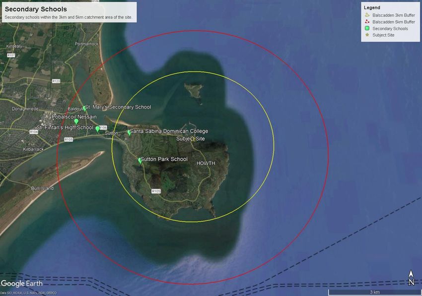
7.3 Existing Secondary School Provision
The number and distribution of primary schools within 5km of the site is illustrated below in Figure 7-2. All
primary schools are of varying scales as shown in Table 7-2 and include a range of schools including boys,
girls, all genders, Irish-medium school and boarding school.
There are 5 no. secondary schools within the 5km catchment area, with 2 no. secondary schools within 3km
from the site. Across 5 no. secondary schools there are a total of 2,713 no. pupils enrolled with 1,099 no. of
places (46.8%) within 3km of the site. Santa Sabina Dominican College is the largest secondary school in the
catchment area with an enrolment of 703 no. pupils in 2020/2021.
The number children enrolled in secondary schools within the catchment area has decreased by 15.6%
between 2019/2020 and 2020/2021.
25Lands at Balscadden
Schools Demand and Childcare Facilities Assessment
No. Secondary Type AddressEnrolled Enrolled Distance
School Pupils Pupils from the
2019/2020 2020/2021 Site
1. Sutton Park Mixed – St. Fintan’s 345 396 c. 2.21km
School Boarding Road, Sutton,
School Dublin 13
2. Santa Sabina Girls Greenfield 669 703 c. 2.36km
Dominican Road, Sutton,
College Dublin 13
3. St. Fintan’s Boys Dublin Road, 703 202 c. 3.58km
High School Burrow,
Dublin 13
4. St. Marys Girls Baldoyle, 267 235 c. 4.30km
Secondary Dublin 13
School
5. Pobailscoil Mixed Irish- School Lane, 729 810 c. 4.55km
Nessain medium Baldoyle,
Dublin 13
Total 2,713 2,346
Table 7-2: Overview of Secondary Schools within the 3km and 5km catchment area from the subject site (Source: www.gov.ie
and Schooldays.ie)
26Lands at Balscadden
Schools Demand and Childcare Facilities Assessment
Figure 7-3: Overview of Secondary Schools within the 3km and 5km Catchment Area (Source: Google Earth, adapted by BSM 2022).
27Lands at Balscadden Schools Demand and Childcare Facilities Assessment 7.4 Proposed Secondary School Provision As noted above in Section 7.2, the DES made a commitment to deliver 40 no. new schools between 2019- 2022, of which 19 no. were secondary schools. There are no new secondary schools proposed within the Donaghmede_Howth_D13 school planning area. A new secondary school was proposed for the nearby area of Baldoyle/ Stapolin in 2021 however has since been deferred. 8 ESTIMATED SCHOOL DEMAND AND ANALYSIS The Minister of Education has set out key priorities for during the National Development Plan (NDP) period 2021-2024 regarding school provision including the delivery of c. 150-200 new school building projects annually to provide necessary additional capacity. 8.1 Estimated Primary School Demand Within Howth ED there are 803 no. primary school aged children (typically 5-12 years old) according to the Census 2016, this has increased by 7.9% since 2011 from 744 no. children. The primary school aged population equates to 9.6% of the total population of Howth ED which is lower than County Fingal as a whole (13.2%). As recorded in the ‘Regional Projections of full-time enrolments, Primary and Second Level 2021-2036’ produced by the DES, it is projected that the Dublin region will see primary school enrolments fall by almost 24% (34,500 pupils) between 2020 and 2036 as illustrated in Figure 8-1. The primary school enrolment figures within Howth ED are in line with these projections and the enrolment numbers gradually decreased from 1,105 no. pupils in 2020/2021 to 1,084 no. pupils in 2021/2022 (1.93%). Figure 8-1: Projected Enrolment at Primary School Level 2021-2040 (Source: Department of Education). As noted in the Provision of Schools and the Planning System: A Code of Practice 2008 it is assumed that an average of 12% of the population are expected to be present for primary education. An analysis of the likely 28
Lands at Balscadden
                                                                   Schools Demand and Childcare Facilities Assessment

primary school demand from the proposed development based on the number of units and the average
household size within Howth ED has been applied in Table 8-1 below:

 Units                         Average HH Size (Howth        Population     of  the      Projected Primary School
                               ED)                           Proposed Development        Population (12%)
 180 (total units)             2.68                          482 no. people              58 no. of children
 114 (total units minus        2.68                          305 no. people              37 no. of children
 studios and 1 bed units)
Table 8-1: Estimated Demand of Primary School Population (Source: CSO 2016).

The demand for primary school places generated by the proposed development is c. 58 no. places, this
equates to c. 7 no. places per year group based of an eight-year primary school cycle. Disregarding 1-
bedroom units applying the same methodology as the childcare demand analysis, the proposed development
generates the need for 37 no. places which equates to c. 5 no. places per year group.

Within the catchment area there are 1,084 no. children enrolled across 4 no. primary schools. Assuming as
one year group leaves 271 no. primary school places will become available (total no. children enrolled in
primary schools / 8 no. years).

Based on this analysis, the demand for primary school places is lower than the estimated school places
available per year, therefore the primary schools within the catchment area will easily facilitate the
anticipated demand from the proposed development. This is further supported by the low enrolment figures
in Killester Rahane Clontarf ETNS which suggests capacity is available.

8.2      Estimated Secondary School Demand
Within Howth ED there are 630 no. children of secondary school (typically 13-18 years old) which equates to
7.5% of the total population of Howth ED. Similar to the primary school population, this is slightly lower than
County Fingal with secondary school children accounting for 7.7% of the total population.

As recorded in the ‘Regional Projections of full-time enrolments, Primary and Second Level 2021-2036’
produced by the Department of Education, it is envisaged that enrolments will increase by 10,694 no. places
between 2020 and 2024 as illustrated in Figure 8-2, however will begin to decrease between 2025-2036 by
16,323 no. places. Given the timeline of pre and post construction requirements, it is expected that the
proposed development will not be habitable by 2024 therefore will not contribute to the secondary school
population until the figures are expected to decrease in 2024.

Whilst it is envisaged that enrolments will increase from now until 2020-2024, enrolment figures in
secondary schools have varied between 2019/2020 and 2021/2022. Sutton Park School, Santa Sabina
Dominican College and Pobailscoil Nessain have seen an increase in enrolments since 2019/2020 which
suggest that there is still capacity available for additional pupils in these secondary schools.

                                                                                                                 29
Lands at Balscadden
Schools Demand and Childcare Facilities Assessment
Figure 8-2: Projected Enrolment at Secondary School Level 2021-2040 (Source: Department of Education).
Based on these figures the proposed secondary school population is set out below in Table 8-2.
Units Average HH Size (Howth Population of the Projected Secondary
ED) Proposed Development School Population (7.6%)
180 (total units) 2.68 482 no. people 37 no. of children
114 (total units minus 2.68 305 no. people 23 no. of children
studios and 1 bed units)
Table 8-2: Estimated Demand of Secondary School Population (Source: CSO 2016).
The proposed development calculates a demand for c. 37 no. secondary school places which equates to 6
no. school places per year group based of a six-year secondary school cycle. Disregarding the 1-bedroom
units there is an anticipated demand of 23 no. places which equates to 4 no. places per year group.
Within the catchment area there are 5 no. secondary schools within a total of 2,346 no. pupils enrolled.
Assuming as one year group leaves this creates capacity for 391 no. new pupils.
Based on this analysis, the secondary schools within the catchment area have capacity to facilitate the
anticipated demand for secondary school places generated by the proposed development as the demand is
significantly less than the capacity available.
8.3 Estimated School Demand Summary
To estimate the demand for primary and secondary school places several factors were considered including
the available school provision within the catchment area, primary and secondary school age-cohorts within
Howth ED, average household size, unit mix and the projected population from the proposed development.
Overall, the demand for both primary and secondary school places generated by the proposed development
is low. It is anticipated that a maximum of 58 no. primary school places and 37 no. secondary school places
are required. It can be expected that the number of places required may decrease in line with the projected
enrolment figures published by the Department of Education.
30Lands at Balscadden
Schools Demand and Childcare Facilities Assessment
Enrolment figures in primary school will decrease until 2033 and whilst enrolment figures in secondary
schools will gradually increase until 2024/2025, it is expected that hereafter enrolments will significantly
decrease.
Therefore, both primary and secondary schools within the catchment area will be able to easily facilitate the
anticipated demand for school places by the proposed development.
9 CONCLUSION
The proposed development of the lands at Balscadden represents an opportunity to deliver new
development offering a quality living environment, respectful of its context, site topography, and site
character, in the heart of Howth Village.
Considering the proposed development’s characteristics; namely unit mix; the demographic profile of the
area; and, the existing and permitted provision of childcare facilities and school provision; we submit that a
childcare facility is not required as part of this development and that the provision of schools within the
catchment area will be able to facilitate the additional demand of the proposed development.
We consider the proposed development to be in accordance with Government guidance in relation to the
Fingal County Development Plan 2017-2023 policies and objectives and all other policies and guidelines as
listed in Section 3.
31You can also read