SUMP Scenarios Glyfada, Greece
←
→
Page content transcription
If your browser does not render page correctly, please read the page content below
Urban Sustainable Mobility in focus: student education,
          community involvement and participative planning

                                  SUMP Scenarios
                                  Glyfada, Greece

                                      June 2021

"The European Commission's support for the production of this publication does not
constitute an endorsement of the contents, which reflect the views only of the authors, and
the Commission cannot be held responsible for any use which may be made of the
information contained therein."

                                                                                         1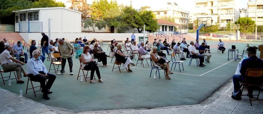
Contents

PART 1. Necessity of Sustainable Urban Mobility Planning .................................................................... 3
   1.1        Why do we need Sustainable Urban Mobility Plans (SUMPs)? .............................................. 3
   1.2   Why is it important to involve residents, businesses and civil society into a participative
   SUMP planning? .................................................................................................................................. 3
   1.3        Aims of the document............................................................................................................. 4
PART 2. Preparation and Analysis ........................................................................................................... 5
   2.1        Planning context ..................................................................................................................... 5
   2.2        Main problems and opportunities .......................................................................................... 7
   2.3        Options for the future ........................................................................................................... 12
PART 3. Alternative scenarios ............................................................................................................... 15
   3.1        Scenario 1. Mild intervention ............................................................................................... 15
   3.2        Scenario 2. Moderate/Dynamic Intervention ....................................................................... 25
   3.3        Scenario 3. Restoration of Sustainable Urban Mobility in the City ...................................... 26
Part 4. Discussion and evaluation of scenarios ..................................................................................... 27

                                                                                                                                                    2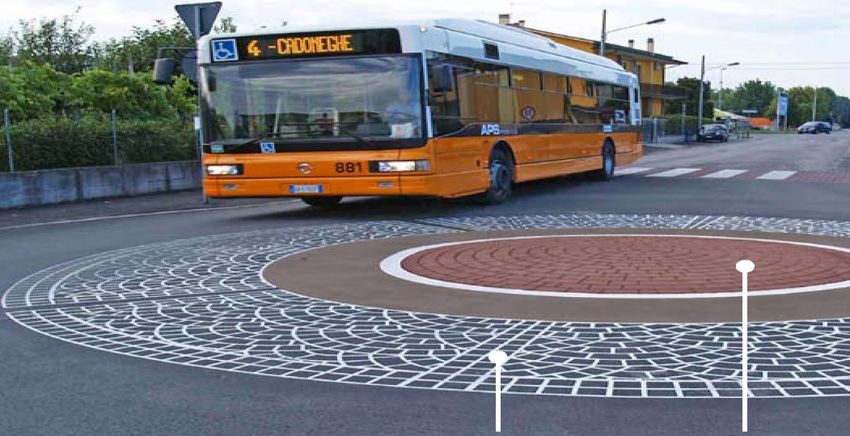
PART 1. Necessity of Sustainable Urban Mobility Planning

1.1     Why do we need Sustainable Urban Mobility Plans (SUMPs)?

Sustainable Mobility is the term used to describe the urban mobility aspect of the future sustainable
city. The term refers to securing safe and friendly mobility conditions for all citizens while limiting
energy consumption and CO2 emissions. This is accomplished through an integrated system of
combined transport, limiting the role of the private car to where its use is absolutely necessary, and
allowing other alternative transport means to become competitive to the car for certain transport
objectives, time periods and routes. Alternative transport means, like the public transport, cycling,
walking, car pooling and car sharing are upgraded in this combined transport paradigm and become
its main components.
Why are we trying to replace the private car with other alternative means of urban mobility? Why
are we trying to shift a paradigm that has been dominant in urban mobility worldwide? The pollution
or the noise that come with the car are valid answers; however, the modern technological progress
is expected to provide solutions to the pollution and noise problems soon – the electric and
autonomous cars technologies are advancing fast and promise to minimize both the pollution and
noise produced by cars, as well as reduce the number of cars on the road with ridesharing
capabilities and reduce the urban CO2 emissions by 80% worldwide.
The main problem with the car-dominated urban mobility paradigm is its impact on the availability
and quality of urban space. Car infrastructure has already taken up a great part of the public urban
space in European cities and continues to do so, with more demand for parking space and new road
networks to facilitate the increasing traffic. The problem of space is especially evident in the historic
centres of European cities, built before the invention of the car and therefore lacking the space
necessary to support increasing car traffic (Chronopoulos, 2015). Moreover, SUMP is promoting a
change of approach in planning, from the offer of means of transport, to the offer of mobility
options. A shift from transfer to mobility: The citizen is no longer regarded as a passive passenger to
be transported to a destination, but as an active citizen able to choose the best way of reaching a
destination. The focus is no longer on means of transport (e.g. private car, public transport) but on
the citizen and on the choices offered to travel in the city in a friendly, safe, comfortable and
healthier way in terms of physical exercise and lower levels of stress.

1.2 Why is it important to involve residents, businesses and civil society into a
participative SUMP planning?

The participation of the local community in Sustainable Urban Mobility Planning is a core component
of the SUMP concept. Active citizens’ participation is in fact key to any contemporary spatial
planning action, whether related to land use planning, urban regeneration projects, or urban
mobility planning. Involving the local community in an informed and active manner guarantees that
the needs and vision of the citizens for their neighbourhoods and cities are taken into account, and

                                                                                                       3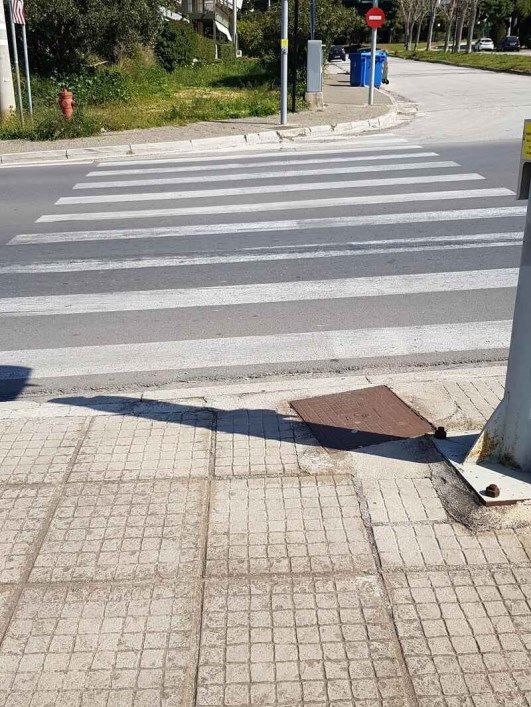
the local community is in a position to understand the overall planning strategy and support the
interventions made in this framework. Moreover, active civic participation plays a central role in
promoting local democracy.
One of the most important aspects of civic participation is the essential participation in the planning
of the city where we live and work. Urban planning in general and SUMPs in particular have, with
their application in the city, serious implications for the way the city operates, affecting our quality
of life on a daily basis. However, although the participation of citizens in spatial planning and
decision-making processes at the local level is a prerequisite in many European countries - as only
through their participation the citizens are informed and aware, in Greece there is poor experience
in quality participation. Young people and women in particular are usually absent from consultation
procedures. The reasons behind the insufficient involvement of citizens in spatial planning processes
reflect the weaknesses of both civil society and local authorities, and are related to ignorance and
lack of awareness on environmental issues, such as climate change and SUMP policies, but also
social issues such as the perception of the "common good" and the need to implement participatory
planning processes at all levels (Information, Consultation, Dialogue, Partnership). Lack of
participatory planning tools and techniques that will inspire confidence in citizens, and a sense of
inadequacy due to lack of necessary knowledge or skills, are also deterring factors (Vlastos,
Bakoyannis, 2019). This stresses even more the importance of the project’s activities regarding the
involvement of residents, the civil society and the local authority in Glyfada.
Indeed it is the first time a SUMP Task Force is created in the Municipality of Glyfada, involving
representatives from the City Council, the municipal departments, civil society organisations, the
local school education community and experts, to research and map the urban mobility issues
through a SUMP approach and develop SUMP scenarios for the future of a case study area. The
interest and dedication demonstrated by the Task Force members throughout the work of the Task
Force, as well as their contribution in mapping urban mobility issues through walking on the streets
of the case study area and using a platform for collaborative mapping in mobile devices (Siftr –
www.siftr.org), and in collaboratively formulating the SUMP Scenarios, reflect the need for such
participative approaches in SUMP and their potential effectiveness.
1.3 Aims of the document
This document aims on one hand at facilitating the project activities foreseen within the Urban
SCOPE project, and on the other hand at providing documentation and a basis for discussion
regarding the future of SUMP in Glyfada, especially in light of the formulation of the first Sustainable
Urban Mobility Plan for the city to commence soon. In specific, the objectives of the present
document are presented below.
Objectives relating to the Urban SCOPE project:
To provide a basis for the learning material to be developed in following phases of the
project (Learning Methodology and Learning Course for secondary education) to be applied
in a secondary school of Glyfada
4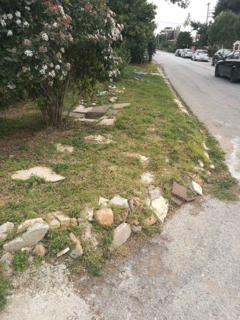
To be employed as reference with regard to the SUMP Competition foreseen in Greece
Objectives relating to SUMP in Glyfada:
To raise awareness of the residents and stakeholder organisations (including the City Council
and other local authority officials) on SUMP in Glyfada, raise the topic on the local agenda
and encourage public discussion on the SUM vision
To encourage SUMP interventions in the case study area, through the approval of an Action
Plan based on the preferred SUMPO Scenario by the City Council
To provide documentation and proposals, as well as good practice examples with regard to
participative planning, especially in light of the formulation of the SUMP of the Municipality
of Glyfada
To provide a basis for educational and awareness raising activities in schools of Glyfada
PART 2. Preparation and Analysis
2.1 Planning context
The city of Glyfada does not have a Sustainable Urban Mobility Plan in place, or any integrated policy
regarding the SUM approach to urban transport. Like the vast majority of Greek cities, Glyfada is a
city of the private car. However, the municipality’s vision is to take decisive steps towards
introducing SUMP policies and interventions. This will of the local authority is evident in the
proposals made in the framework of the urban mobility guidelines included in the Glyfada Urban
Plan, soon to be approved and guiding the city’s spatial development for the next 20 years.
The urban mobility strategy expressed in the Glyfada Urban Plan through guidelines and general
proposals for interventions, that have to be further examined and specialised in an integrated SUMP
for the city, adopts the SUMP approach to urban mobility and disregards the traditional car-based
strategy expressed by a transport plan prepared 8 years ago for the city of Glyfada (but never
approved by the city council). It accepts that the approach recognising car use as the necessary
factor to support the various commercial and recreational land uses in the city centre has been
rendered obsolete by the recent European developments in urban mobility policy and practice.
Consequently, the Plan proposes to establish a low traffic zone in the city centre that takes away
space from cars (street and parking space) and allocates it to space for safe walking and cycling
options to access the centre. This will be achieved through an integrated parking policy and the re-
design of public space, including the maintenance and redesign of pavements, and the creation of
pedestrian ways and an integrated cycleway network. Moreover, through the development of a
wide esplanade that connects a green space next to the city centre with the – soon to be
regenerated – seafront, it aims to encourage local residents and visitors to take long walks for
recreation purposes. The Urban Plan’s strategy also includes a proposal for gradually reducing the
car speed limit to 30km/h (from 50km/h) in all residential neighbourhoods of the city, and proposes
5
design solutions to promote walking and upgrade the position of the pedestrian when met with car
traffic by unifying the pedestrian space (see Image 6 below). As a rule, with the exception of the 2
main road arteries crossing the city in a north to south direction, the strategy proposes to decrease
the car speed on busy streets by introducing roundabouts (see Image 7).

Image 1: The diagram on the right presents an alternative to the conventional model on the left
regarding the pedestrian crossings. Source: General Spatial Plan of Glyfada, PRISMA, 2016

                                                             Image 2: The roundabouts can help in
                                                              maintaining constant traffic flows at
                                                              lower speed. Source: General Spatial
                                                              Plan of Glyfada, PRISMA, 2016

The urban mobility strategy of the Urban Plan also refers to the concept of Flexible Transport
Systems. These cover the gap between the more flexible but also more expensive taxi service, and
the less flexible conventional public bus service; they include a wide range of means like minibus
service, and demand-responsive transport, as well as special transport services (e.g. for disabled
persons or school pupils).
Car-pooling and car-sharing are also included in the urban mobility services proposed for Glyfada;
the strategy proposes the creation of a “mobility office” in the local authority that will be
responsible for coordinating the implementation of the SUMP and related interventions, including

                                                                                                   6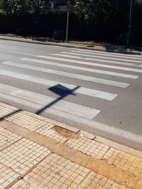
the management of car-pooling and car-sharing online platforms dedicated to offering secure and
safe service to users.

Finally, the urban mobility strategy proposes the development of a wide cycling network and
promotes the creation of a municipal system for bicycles to rent in order to encourage potential
cyclists to use the bicycle for their everyday trips for work or recreation – it estimates that a fleet of
300-400 bicycles and 25-35 bicycle stops would be sufficient for the starting phase of the system.

2.2     Main problems and opportunities
Glyfada, similar to other cities forming the Athens Metropolitan Area, has been developed with the
private car at the centre of the urban transport approach. Located at a distance of around 12 km
south of the centre of Athens, and still not connected through fixed track means (e.g. railway, tram,
metro), the city has always depended heavily on the private car use. This has had a profound impact
on both the layout of the city – with 2 major road arteries crossing it and a significant part of the city
surface being dedicated to road and parking infrastructure – and the mentality and attitudes of the
local residents and businesses strongly in favour of the car. A steep population increase through the
decades has led to Glyfada being expanded to its natural limits (mouth Hymmetus to the east and
the sea to the west), reaching its maximum population capacity, and resulting in an ever increasing
number of cars on the roads. These factors, together with the city’s strong dependence on the
private car and motorcycle, and a chronic problematic planning enforcement common to the
majority of Greek cities, have also led to alternative mobility means and their corresponding
infrastructure falling into contempt.
Walking, the simplest autonomous mobility option to cover small and medium distances, has to a
large extent been stripped of its minimum necessary infrastructure: pavements offering safe and
free passage to pedestrians, including citizens with special mobility needs (i.e. disabled, parents with
baby strollers etc.). Although the city plan allocating sufficient width to pavements has been
implemented in practice, the existing pavements often are not in a condition to facilitate pedestrian
mobility. They are often blocked by municipal waste bins, public utility infrastructure, parked cars or
motorcycles, trees and plants etc., they have often been turned into gardens or parking spaces by
the local residents, or have been damaged to such an extent that no longer offer a safe passage. As a
result, in the case study area it is common for pedestrians to use the street to walk, putting
themselves in danger from oncoming traffic, or engaging in a slalom to avoid obstacles on the
pavements. The situation is even worse when it comes to citizens with special mobility needs, like
the elderly, disabled persons on wheelchairs or parents with baby strollers.

Although cycling is popular in the case study area among teenagers who often cycle at leisure for
short distances to access a local sports facility or meeting place, cycling is hardly a reliable mobility
mean for everyday trips in Glyfada. The lack of cycling infrastructure like cycle lanes or cycle ways
that can offer a safe space for cyclists, as well as bicycle parking facilities, together with the
mentality of the average Greek driver against sharing the street with other users, do not encourage
locals to cycle.

                                                                                                        7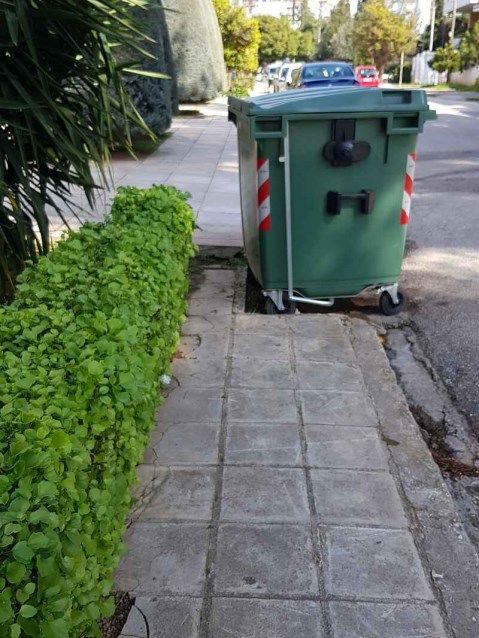
Public transport in the case study area is limited to main line bus routes. Although main line bus
service covers a good part of the case study residential areas, its limited reliability in terms of
punctuality, the delays resulting from it being subject to traffic jams, and the lack of reliable live
information on estimated times of arrival and trip duration, do not render it competitive against the
use of the private car.

The municipal bus service operating in Glyfada in the last few years could prove an important
instrument in connecting residential areas to main destinations in Glyfada and the Metro station just
outside the city borders. However, the 2 available routes were designed as circular in order to cover
a bigger area of the city and therefore facilitate a greater number of citizens, sacrificing direct access
to destinations and resulting in long travel times.
The dominance of the private car is evident when it comes to parking. The great number of cars on
the streets of Glyfada does not correspond to the available parking spaces, especially during rush
hours in the city centre and local neighbourhood centres. Cars park on pavements, double or even
triple park on the streets, and block access to private car parks or access ramps on pavements. Until
now there has not been a parking control system, and the work of the municipal police has not been
effective in reducing the illegal parking phenomena.
Regarding the SUM situation described above, we need to take into account that until today there
has not been any SUM Plan or an integrated SUM policy in place by the municipality. However, this is
about to change; the current mayor and the city council have openly declared their commitment to
developing a SUM Plan for the city, having for the first time assigned the formulation of the Plan to
an experienced team of experts. Moreover, the city council has approved the new Urban Plan of
Glydafa which includes a framework for developing SUM interventions. In addition, the municipality
participates as a partner in the Urban SCOPE project; the project gives a precious opportunity for
participative planning involving the residents and the civil society, raising the SUMP topic in the local
agenda, and launching related educational and awareness-raising activities in Glyfada.

                                                                                                        8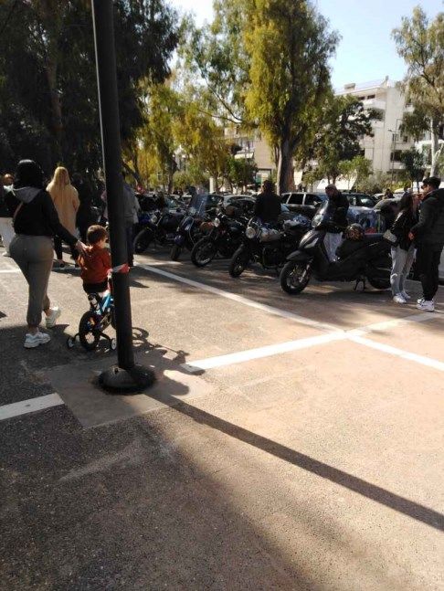
The following tables present a SWOT analysis with regard to SUMP in the city of Glyfada:

                A framework of SUMP guidelines is included in the city's Urban Plan, currently under
                approval.
                Recent Urban Plan covering the whole municipality and planning the urban space in 6
                new operational neighbourhoods, each including residential areas and the necessary
                services for the residents (commercial centres, education and sports facilities, open and
                green spaces etc.), thus supporting the adoption of a SUMP that promotes alternative
                and competitive mobility options to the private car to cover shorter distances on a daily
                basis (15-minute city approach).

                Municipality's participation in the Urban SCOPE project as partner and implementation
                of project activities key for promoting a SUMP approach to urban mobility, like the
                following:
                - SUMP Research for Glyfada and the case study area
   Strengths

                - Creation and effective collaboration of a SUMP Task Force, involving a wide range of
                local stakeholders
                - Documentation and mapping of SUM issues in the case study area
                - Formulation of SUMP Scenarios for the case study area
                - Presentation of the SUMP Research and Scenarios in an event with 70 participants,
                engaging the local community in a discussion about SUMP in Glyfada and raising the
                topic in the local agenda

                Strong political support by the Mayor and the City Council for developing and
                implementing the Glyfada SUM Plan
                Presense of an active civil society, committed to engage in collaborative planning
                processes and to participate in the SUMP process

                Generally adequate width dedicated to pavements throughout the city street network

                Operation of a municipal bus service, complemented by independent bus stops
                equipped with a seating area and electronic information board

                Absence of a Sustainable Urban Mobility Plan and municipal SUM policy framework
                Local authority's lack of experience in participative approaches to planning and
                processes of SUMP monitoring
   Weaknesses

                Two major metropolitan highways cross the city (Poseidonos Highway and
                Vouliagmenis Highway), acting as barriers to the mobility of pedestrians and
                bicycles/scooters from the residential areas of the city to the city centres and the
                seafront
                Current mobility practice and attitude of the residents strongly in favour of the private
                car use, based on decades of car domination in urban mobility; lack in education and
                awareness-raising on the subject of SUMP

                                                                                                       9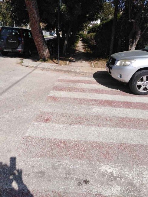
Pavements are in their majority not friendly for pedestrians and citizens with special
                mobility needs like the disabled and parents with baby strollers; they are either blocked
                (by plants, trash bins, amenity infrastructure, street furniture etc.), taken over by other
                uses (e.g. turned into private gardens or parking spaces by the residents), absent or in
                need of repair, and lack access ramps. As a result, most pedestrians have to walk on the
                streets.
                Absence of Metro stations in the city, connecting it to other destinations in the Athens
                Metropolitan Area
                Municipal bus service routes are circular, planned to cover as many areas of the city as
                possible, but not taking the mobility demands of the residents into account; this results
                in long trips, constituting it non competitive to the private car.
                Main line bus service is not popular among residents, due to the outdated bus stops,
                lack of live information on the bus arrival, inconsistency of bus arrivals etc.
                Minimal and fragmentary bicycle infrastructure (e.g. cycle lanes, cycle ways, bicycle
                parking spaces), absence of an overall plan for a bicycle network
                Problems related to car parking, especially in commercial areas (e.g. city centre); cars
                are parked on pavements, blocking residential car parking ways, or are double-parked
                especially during rush hours

                Formulation of the Glyfada Sustainable Urban Mobility Plan to commence, covering the
                whole city and foreseeing participative planning processes involving the residents and
                civil society

                The existing and foreseen SUMP infrastructure on the city seafront (pedestrian ways,
                cycle ways, car parks) and proposed crossings for pedestrians and bicycles on the 2
                major metropolitan highways, could integrate into an overall SUMP for the city

                The education and awareness raising campaign foreseen in Glyfada in the framework of
                the Urban SCOPE project (including the SUMP Competition) could encourage a more
                friendly attitude of the residents and businesses towards SUMP, their active
Opportunities

                participation in the formulation of the SUMP of the city, and the support of the local
                community towards the SUMP interventions

                The knowledge and experience gained by the Municipality through the participation in
                the project activities of Urban SCOPE, i.e. the SUMP Research, the collaborative work of
                the SUMP Task Forse and the formulation of SUMP Scenarios, could be used further to
                establish participative planning processes and SUMP monitoring protocols

                Glyfada could be promoted as the first SUMP city in the Athens Metropolitan area,
                investing in civic pride and attracting investments related to SUMP infrastructure and to
                other fields
                Restructuring the municipal bus routes, utilising the existing bus stops infrastructure
                and complementing it, in order to address the mobility needs of the citizens by offering
                a competitive option to the private car for everyday trips
                Taking advantage of modern smart city applications regarding car parking and
                combination of mobility means

                                                                                                        10
The future creation of 3 Metro stations in Glyfada, as foreseen in the expansion plans of
the Metro company (Attiko Metro), can be integrated to the SUM Plan in order to offer
more mobility options with regard to combining the Metro with other autonomous
mobility means (walking, cycling, scooters etc.) and other public transport means (main
line and municipal bus networks)
The dominant attitude of the local community (residents, businesses) in favour of the
private car, together with a general reluctance for a change in lifestyle and everyday
mobility practices, may lead to a SUM Plan that lacks the brave decisions and important
interventions needed to make Glyfada a city friendly for the pedestrian and the bicycle
The lack of experience and administrative capacity by the Municipality in developing
SUMP interventions, monitoring their effectiveness and engaging in effective
participative planning processes, may limit the potential impact of the SUM Plan
The simple and yet crucial interventions needed to make Glyfada a city friendly to
pedestrians, including citizens with special mobility needs, may require substantial
Threats
funding that may not be easily secured. In addition, requiring the financial contribution
of real estate owners in the city to repair and re-design the pavements (as is foreseen in
the municipality regulations) may incur political cost
Taking into account that the city of Glyfada is a south suburb of the Athens
Metropolitan Area, neighbouring with urban municipalities to the north and south and
in effect being part of a continuous urban area, it is necessary to collaborate with the
neighbouring municipalities at the planning stage in order to make sure their SUMPs
complement each other and offer maximum benefits to their citizens. For example, a
cycling network in Glyfada should not stop at the borders of the municipality, but
should connect with the respective networks of adjacent cities. Unfortunately, there is
no substantial collaboration experience between municipalities in the Athens
Metropolitan Area and this could put this integrated approach in danger
112.3 Options for the future
Technology to substitute the conventional car
Sustainable Urban Mobility is the mobility paradigm of the future city, aimed at reducing the CO2
emissions produced by conventional urban transport in cities across the world. A key objective of
SUM is the reductions of the private car and motorcycle’s role in everyday urban mobility, as the
main polluters, and the promotion of cleaner alternatives and their combination, as competitive
options in terms of economic, health, social and environmental criteria. But what if the conventional
car was substituted by a cleaner vehicle?
The electric car is on its way to future cities as a clean alternative to the conventional, internal
combustion engine can we use today. How clean the electric car really is, depends on how clean the
source of the electric power it uses really is; in Greece today most of the electric power produced is
still not carbon-free, coming from burning natural gas and lignite (63% in 2019). Moreover, the
prevalence of the electric car will not solve the issue of the increasing number of cars on our streets
and the need for increasing investment in infrastructure to accommodate for their needs in terms of
space (roads, parking spaces etc.).
Another vehicle coming even further in the future to substitute the conventional car, is the
autonomous car, i.e. the electric vehicle that can drive itself with little or no involvement of the
human passenger; the idea is that autonomous vehicles could transport passengers on demand with
safety and comfort, and the passengers would not own such a vehicle but would pay for the service.
In terms of urban mobility, the arrival of the autonomous car would bring many benefits, ranging
from the need for a much smaller number of vehicles on the streets, to less space needed for their
use and parking. However, important issues are still to be resolved before the fully autonomous cars
become a reality in our daily lives in cities; issues not limited to the field of technology, but also to
legal issues and philosophical issues. The autonomous car will probably not come soon, and the
planet is running out of time.
The role of new technologies in SUMP
The emergence of new technologies in the field of urban transport can have an important impact on
the way we drive, the way we cycle, even the way we walk, and on our ability to offer feedback and
participate as active citizens in the design of the urban mobility policies.
New technologies focusing on the car can make it safer for other street users; technologies that can
help monitor and regulate the car speed, the visibility of the car driver, detect the driver’s tiredness
and map his/her attitude as a driver based on information collected by car sensors. Moreover,
modern GPS technology can navigate drivers away from traffic congestion areas and help limit the
aimless car trips: there are a great number of aimless car trips every day, a classic example being the
case where a driver is searching for a parking space; GPS technology can provide solutions by
offering live information on the availability of a parking space, also giving the option to book it.
GPS technology can also be employed in the field of bike sharing, making it no longer necessary to
develop costly bicycle stations by equipping all new generation bicycles with GPS. In this way, the
12bicycles can be traced through a mobile device (smartphone, tablet), picked up through a mobile
application and left at the user’s destination, wherever that is. Dockless bike sharing can have an
immediate impact on Greek cities, because private dockless bike sharing companies are now in a
position to make available a great number of bicycles in Greek cities within a very short time, thus
encouraging citizens to use the bicycle and broadcast a SUMP message wide and clear.
The GPS and telematics technologies can also find effective applications in public transport, offering
to the passengers waiting at a stop or station live and reliable information on the estimated time of
arrival of a bus or train, while inside the vehicles the system can offer valuable information regarding
the itinerary, alternatives for combined use of different public transport means, as well as
information on places of interest and life in the city.
Finally, the internet and ICT applications in the field of crowdsourcing and communication, can
enhance the way citizens can offer feedback or proposals for interventions in the city. Such
proposals may include improvements to the walkability or cyclability of certain areas, pointing out
problems and dangers in the transport network and suggesting solutions. Moreover, they can
enhance civic engagement and participation of citizens of different profiles (ages, genders,
educational backgrounds, etc.) to planning.
The city we want
Through the interviews, the online survey, focus group meetings and the work of the SUMP Task
Force in Glyfada, there was an effort to paint the picture of the future city in terms of urban
mobility. Participants shared their views on the SUMP future of Glyfada, focusing on the case study
area. Future Glyfada would have the following characteristics:
A city friendly to pedestrians: The current issues related to walking in Glyfada were raised by
the majority of the participants. Turning Glyfada into a city that is friendly and safe for
pedestrians, including citizens with special mobility needs, was stressed as a crucial part of
the future city. Providing safe and suitable infrastructure for walking like pavements and
pedestrian ways, as well as safe crossings and complementary infrastructure like benches
and green spaces that can be enjoyed and appreciated by pedestrians, are necessary in
order to encourage citizens to walk more.
A city that welcomes the bicycle and scooter: The bicycle was recognized as an ideal mean
for covering short and medium distances in the city; moreover, the electric bicycle can help
cyclists with the steeper gradients of neighbourhoods closer to the foot of mount
Hymmetus. The scooter and the electric scooter are also becoming more popular among the
citizens of Glyfada. Both the bicycle and the scooter are autonomous mobility means that
cover greater distances faster than walking and can be easily combined with other mobility
means like public transport (bus, metro, tram) or the car. However, both means need to be
protected when they come close to car traffic, and also need a space separate from
pedestrians in order to be safe and effective in terms of travel time on an everyday basis.
They need to be welcomed in the city as reliable options for covering everyday mobility
needs, and not just for leisure.
13 A city with municipal transport services that respond to the mobility needs of citizens:
Municipal bus service in future Glyfada must respond to the actual mobility needs of the
citizens, filling in the gaps of main line bus transport, and not just providing more main line
bus routes. It needs to be flexible and provide a competitive option against using the private
car.
A city connected through key public transport networks, like the Metro: The development of
Metro stations in Glyfada has been a long-standing request of the city council and the local
community. The creation of 3 Metro stations in Glyfada, as foreseen in the extension plans
of the Attico Metro company, will offer quick connection to Athens and other areas in the
Athens Metropolitan area, and will boost the SUMP potential of Glyfada by offering more
options to the citizens.
A city where the role of the car is respected but controlled: The private car and the
motorcycle cannot be banned from Glyfada, as they are used by the vast majority of the
citizens today for their everyday mobility needs. However, although in the future city the
role of the car in urban mobility is respected, it should also be controlled, leaving room for
alternative means and combinations of means to become competitive, and also promote
combinations of the car and other mobility means (e.g. Park and Ride approaches). Moving
away from the car is a gradual process that will take time, especially in a city like Glyfada
which depends on it. It will require SUMP infrastructure and measures to make alternative
mobility choices competitive to the car, together with a dedicated education and awareness
raising campaign.
14PART 3. Alternative scenarios
The SUMP Task Force has developed 3 SUMP Scenarios, corresponding to different levels of
intervention and periods of implementation:
1. The Scenario of Mild Intervention with implementation in the short term (2021-
2022)
2. The Scenario of Medium-Dynamic Intervention with implementation in the medium
term (2022-2025)
3. The Scenario of Restoration of Urban Sustainable Mobility in the City, with
implementation in the long term (2025-2030)
The proposed scenarios are, in summary, the following:
Scenario 1 – Mild Intervention: It focuses on improving the movement of pedestrians and
selectively of bicycles, while it foresees improvements in the municipal bus services, the
adoption of a parking control system in areas where there is a high concentration of cars
(Glyfada city centre), measures to discourage illegal parking and the allocation of parking
spaces for people with disabilities and bicycles.
Scenario 2 – Medium/Dynamic Intervention: It focuses on the creation of an integrated
cycling network and the gradual replacement of municipal bus vehicles with electric
vehicles, the application of electronic information on the routes and timing of buses, the
construction of multi-storey parking spaces where there is a concentration of vehicles and
phenomena of illegal parking, the creation of electric car charging stations, and the
introduction of incentives for switching to electric vehicles and car sharing. The Scenario
also foresees the full restoration and re-design of pavements for unhindered pedestrian
mobility.
Scenario 3 – Restoration of Sustainable Urban Mobility in the City: The traffic of
conventional cars is drastically reduced and the charging stations and incentives for electric
cars are increased, the walking and cycling networks are maintained so that the movement
is seamless and safe, the replacement of municipal buses with electric vehicles is completed
and the municipal bus network is expanded acquiring the main role for the mobility of
citizens with vehicles and the connection of all the areas of the Municipality with the
transport means of fixed track (metro, tram), on-demand municipal bus service is
introduced for the areas further away from the centre, and the integrated cycling network
and the multi-storey parking buildings are completed.
The proposed Scenarios are presented in detail below, with regard to their foreseen
interventions.
3.1 Scenario 1. Mild intervention
Approach: The role of the car is not limited, but walking and cycling are strongly facilitated.
The proposed interventions in this scenario are divided into top priority interventions
(within 2021 in blue) and priority interventions (in 2022).
15Implementation of the corresponding Action Plan: Immediate (2021-2022)
Priorities:
1. Improving the walkability of pavements through
o Removal of obstacles (see Image 3) or construction of small technical works to
ensure the minimum width for free passage of pedestrians and wheelchairs (1,50 m
or in the case of existing pavements of smaller width, 0,80 m).
Priority for immediate intervention in 2021:
Removal of the municipal waste bins in places where the width of pedestrian
passage is reduced below 80 cm, and especially from pavement corners where
they prevent access to accessibility ramps.
Removal by the Municipality of low vegetation which reduces the passage width
of pedestrians
In cases of big trees and public utility infrastructure (e.g. electricity poles) which
reduce the passage width to less than 80 cm, the width of the pavement is
extended locally at the expense of one car parking space.
o Repair of pavement surfaces (see Image 4) — activation and improvement of the
Municipality’s regulations on the responsibility for the construction, reconstruction
and repair of municipal pavements.
Priority for immediate intervention in 2021:
Repair/construction the surfaces of pavements that fall under the responsibility
of the Municipality (e.g. in front of municipal buildings), by municipality
workers.
Repair by municipality workers of the pavements especially where deep
potholes or steps are observed and create “traps” for pedestrians and
wheelchairs, putting them in danger of injury. Pavement surfaces should be
normalized In areas where private parking ramps create obstacles to the
movement of wheelchairs – a common phenomenon. In cases where the
obstacle cannot be removed, a coloured marking should be placed to warn the
pedestrians.
o Cooperation with the Municipal Police for the removal of cars parked on the
pavements (see Image 5), placement of physical barriers along the pavement and
warning signs for the imposition of fines and removal of cars in case of parking on
the pavement.
Priority for immediate intervention in 2021:
Imposing a fine on cars parked on the pavement
16 Placement of physical barriers along the pavement, in areas where the
phenomenon of parking on the pavement is more often observed (e.g. at the
Glyfada city centre)
Placing “No Parking” signs with an image of a crane removing a car, to warn that
trespassers’ cars will be removed
Image 3: Pavement layout by the Municipality Image 4: The pavement has been
for placing the waste bin, which in practice transformed into a green area by
cancels the pavement. Socratous Street. residents. Corner of Socratous and Meg.
Alexandrou Streets.
Image 5: Cars parked on the pavements in residential area.
172. Pedestrian crossings
Priority for immediate intervention in 2021:
o Immediate improvement of street marking on pedestrian crossings (renewal of
markings, most of which are erased) – see Image 8.
o Location of pedestrian crossings: Need to review the location of crossings in areas
which are dangerous for pedestrians (e.g. near street corners), remove obstacles in
contact with the crossings and place access ramps at the length of the crossings (see
Image 6) — Need for immediate intervention!
o Highlighting the marking of pedestrian crossings especially when they are not
accompanied by traffic lights and offer access to places of gathering (e.g. schools,
sports and/or green areas, public and municipal services, etc.), with red columns,
signs and lights with a button for the pedestrians – see Image 7. Considering
redesigning the crossings by raising the crossing level to the level of the pavement,
forcing cars and motorcycles to reduce speed (see case of Image 9). Especially in
school areas, volunteers (e.g. among the school staff or parents) can attend to the
safe arrival/departure of students.
o Suggestions to the Municipality for the design of new pedestrian crossings in the
case study area, in places that facilitate access for pedestrians to gathering points
(e.g. schools, sports areas and/or green, public and municipal services, etc.)
o Design of overpasses over Vouliagmeni Highway at points close to schools (e.g. at
the intersection with R. Feraiou street).
o Reducing the speed limit in residential areas to 30 km/h, placing signs — Need for
immediate intervention!
Image 6: Pedestrian crossing without Image 7: Example of signposted pedestrian
accessibility ramps crossing with solar panels on D. Gounari street
(Source: www.zafeiropoulos-sa.gr)
18Image 8: Crossing on D. Gounari street (tennis Image 9: The marking of the crossing near a
courts) without an accessibility ramp and high school is not clear.
speed traffic
193. Public and Municipal Transport
Priority for immediate intervention in 2021:
o Review of all bus stops with regard to passenger safety (e.g. Image 8, Image9)
o Review of the municipal bus stops, with a view to changing the routes so as not to
cross too narrow streets
o Review of the routes of the municipal bus service, connecting the routes to the
nearest metro station, also taking into account the school schedules to facilitate
arrival and departure of students.
o Offering information about routes and stops. At municipal bus stops, the available
electronic panels should be activated in order to offer live information about the bus
arrival.
o Design of the bus stops so that there is an access ramp for wheelchairs or baby
strollers. Construction of platforms at bus stops where necessary in order to reduce
the elevation between the bus entrance and the stop, thus facilitating the boarding
of citizens with special needs (e.g. seniors)
Image 10: Bus stop on Vouliagmenis Image 11: Municipal bus stop on D.Gounari
Highway. There’s no adequate pavement or street. Very small waiting area and at a very
acces ramps. Very small waiting area and at short distance from the road (high speeds of
a very short distance from the high speed oncoming traffic).
traffic.
204. Parking
Priority for immediate intervention in 2021:
o Allocation of parking spaces for people with disabilities in all areas where parking is
permitted
o Allocation of spaces for bicycle parking in schools and outside municipal buildings
and places of gathering
o Allocation of parking areas specifically for motorcycles, forbidding illegal parking
concentrations (Image 12)
o Adoption of a parking control system by placing parking meters in shopping areas,
the city centre being a priority.
o Creation of the parking spaces foreseen in the Glyfada Urban Plan for cars and
motorcycles around the city centre.
Image 12: Illegal parking of motorcycles on the Lambraki
pedestrian street
215. Cycling
Priority for immediate intervention in 2021:
o Creating a cycling route in the new municipality project, the Peripheral Road of
Aixoni, turning a lane (or part of it) of the new road into a cycling lane, with the
appropriate marking.
o Examine the alternative proposal for the creation of a cycling route along the
M.Alexandrou street, a street parallel to Vouliagmeni Highway, wide enough to
facilitate the creation of a cycling lane that allows the movement of bicycles on the
North-South axis. This cycling lane can be connected to a new cycling lane on
R.Feraios street offering access to the 2nd Gymnasium of Glyfada, that will cross the
Vouliagmenis Highway, connect to the existing cycling route of Agios Nikolaos street
and reach the Glyfada Golf with one branch, while with another branch it can reach
the planned seafront cycling route through the Lambraki wide pedestrian street (see
Image 13).
o In the framework of the Glyfada SUMP formulation, the proposal to introduce one-
way traffic streets should be examined, in order to provide for wider pavements
and/or the creation of cycling ways. This proposal should especially be examined
with regard to the two-way residential streets of the case study area, east of
Vouliagmeni Highway.
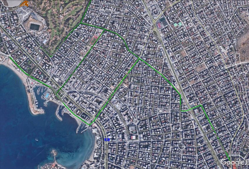
22Image 13: Proposal for a local cycling network that connects the case study area with the city centre, the Glyfada Golf and the seafront area.
236. Education and awareness raising campaign
o A campaign to inform and raise awareness among the residents of Glyfada on
the benefits of SUMP, with the cooperation of Municipality and civil society
organisations, research centres and academic organisations (e.g. Sustainable
Urban Mobility Team of the National Technical University of Athens). The
campaign, which will aim to inform residents about sustainable urban
mobility measures adopted and implemented, as well as raising awareness
about SUM, may include:
Priority for immediate intervention in 2021:
Design and creation of electronic and printed information
material
Social media campaign
Organisation of Workshops/Conferences
Organisation of open workshops where citizens will be invited
to share their views and proposals on SUMP in Glyfada
Presence in the media (radio, television)
o Implementation of educational activities in the schools of the Municipality,
with the participation of students’ parents.
7. Administrative capacity of the Municipality towards sustainable urban
mobility
Priority for immediate intervention in 2021:
o Establishment of a Sustainable Urban Mobility Department in the
Municipality, responsible for:
The implementation of the Glyfada Sustainable Urban Mobility Plan
Monitoring and evaluating the impact of interventions in the field of
SUM, and offering feedback to the Plan;
The cooperation with other departments and services of the Municipality
so that any interventions in other fields (e.g. cleaning, technical
infrastructure etc.) take into account the guidelines of sustainable urban
mobility.
The coordination of information and education/awareness raising
activities of the Municipality in the field of SUMP
Representing the Municipality in cooperation/promotion networks in the
field of SUMP, in Greece and at European/international level
243.2 Scenario 2. Moderate/Dynamic Intervention
Approach: The private car traffic is selectively reduced, the free movement of
pedestrians and bicycles is restored, the municipal transport is significantly
improved.
Horizon of implementation: Medium-term (5 years)
This Scenario includes the measures and interventions foreseen in Scenario 1, and in
addition foresees:
o Creation of a cycling network that will serve the entire case study area, and
municipal bicycles are installed for use of a few hours.
o The municipal bus vehicles are gradually being replaced by electric vehicles.
o Public and municipal transport is reinforced by redesigning routes based on
research and passenger needs analysis in Glyfada in order to offer targeted
transport services.
o Electronic information tables are installed to all bus stops, and applications
for mobile devices with live information on bus arrival times at stops are
introduced for citizens.
o The traffic of private cars and motorcycles is selectively restricted (e.g. on
central commercial roads, which are redesigned as low traffic streets
introducing traffic calming interventions)
o Creation of electric car charging stations, introduction of incentives for
electrification and car sharing.
o Extension of parking control to the areas of neighbourhood centres.
o The construction of the planned multi-storey parking buildings for cars and
motorcycles (foreseen by the Glyfada Urban Plan currently under approval)
around the city centre begins.
o The number of pedestrian crossings is increased, their clear marking is
established and strict fines are foreseen for cars that do not stop when
pedestrians cross.
o All obstacles from the pavements are removed, ensuring the minimum width
of free passage; pavements are equipped with access ramps and the
Municipality’s regulation on pavements is fully enforced.
o The communication and awareness raising campaign unfolds further.
253.3 Scenario 3. Restoration of Sustainable Urban Mobility in the City
Approach: Use of the car is drastically limited, the networks of unobstructed mobility
of pedestrians and bicycles are completed, municipal and public transport takes on a
key role in citizens’ mobility.
Horizon of implementation: Long-term (10 years)
This Scenario includes the measures/interventions foreseen in Scenario 2, and in
addition:
o The traffic of cars is restricted in many areas of the city,
o Priority is given to electric cars with regard to parking, especially in shopping
areas and places with high demand for parking
o Car-sharing is strongly promoted
o Municipal transport service on demand is introduced for the most remote
areas of the city
o The cycling network connected to Metro stations and public transport stops
is completed.
o The multi-storey parking buildings around the Glyfada city centre are
completed
26Part 4. Discussion and evaluation of scenarios
The Scenarios developed by the SUMP Task Force of Glyfada and presented above do not
contradict each other; on the opposite, the approach employed by the Task Force was to
develop the 3 Scenarios based on their implementation timeline, representing 3 different
levels of SUM integration – the Scenario of Mild Intervention in the short term, the Scenario
of Moderate/Dynamic Intervention in the medium term, and the Scenario of Restoration of
SUM in the City in the longer term.
In relation to the Scenario of Mild Intervention, it is worth to point out that although it
represents the first stage of SUMP integration, it does not lag behind the other 2 Scenarios
in terms of intensity, as it foresees a great number of important interventions to promote
safe walking and accessibility for all citizens, the integration of the bicycle in urban mobility
as a reliable option, the upgrade of the role of municipal bus services, the promotion of SUM
amongst the local community through education and awareness raising activities, and the
administrative capacity building necessary for the Municipality to further unfold and monitor
SUMP in the city. Although the interventions proposed under this Scenario spread across a
wide range of themes related to SUMP and constitute important steps towards SUM in
Glyfada reflecting a substantial shift in the city’s urban mobility paradigm, the Task Force
deemed them as the minimum necessary – and in some cases urgent – interventions to
direct Glyfada towards SUM. The following Scenarios of “Moderate/Dynamic Intervention”
and “Restoration of SUM in the city” represent different levels of SUM integration, built
upon the directions and interventions of the first Scenario.
The Scenarios were presented to the city council members, local authority officials, experts
in SUM, representatives of the local civil society and school education community, as well as
citizens of the case study area, through a public consultation event held at the courtyard of
the 2nd Gymnasium of Glyfada (located at the centre of the case study area) on 28th June
2021. Due to the pandemic restrictions still in place in Greece at the time of the event,
requiring the participants to be seated at a distance from one another and wear masks, the
number of participants was limited to 70 persons, although the local community showed a
great interest in attending and given normal circumstances the number of participants
would have been greater. The event gave the floor to SUM experts in Greece who presented
the SUM strategies promoted at European level and their potential adoption in Glyfada, as
well as current trends and good practices for developing SUM models. In addition, Task
Force members presented the Urban SCOPE project, the findings of the SUMP Research
carried out in Glyfada, and the 3 SUMP Scenarios formulated. Following the presentation of
the Scenarios, the floor was given to several participants who offered their feedback on the
proposed scenarios.
The interest shown by the event participants was reflected in the number of comments and
views expressed, resulting in the delay of the event’s closing time by an hour. All the
participants expressed their support and appreciation in the collaborative work carried out
by the Task Force, and the SUMP Scenarios presented. There was discussion regarding the
27current issues related to walking, cycling and public transport, as well as the city’s heavy
dependence on the private car, evident in many neighbourhoods of Glyfada through
phenomena of the car’s dominance over the urban space dedicated to other uses and
mobility means. The majority of the participants also expressed the urgent need for change
in order to reduce CO2 emissions and fight climate change, while at the same time employ
healthier, more affordable and less stressful mobility lifestyles and enable residents and
visitors of Glyfada to enjoy the city by walking and cycling.
Although the urgent need for intervention was widely recognized among the participants,
there was also a concern regarding the pace of the SUM integration approach to be adopted
and to what extent the proposed package of interventions in each Scenario is realistic.
Taking into account that the 1st Scenario proposes interventions that are at this stage
realistic to implement, while also paving the path towards a deeper SUM integration and
allowing the Glyfada SUM Plan process (commencing soon) to unfold and integrate in its
proposals the foreseen Scenario 1 interventions while also taking into account the proposed
interventions in the two Scenarios that follow, the majority of the participants (including the
vast majority of the city council members) decided on the Scenario 1 – Mild Intervention as
the preferred scenario.
The interventions foreseen in the preferred Scenario will be included in an Action Plan to be
presented for approval by the City Council. The Action plan will outline all interventions
foreseen and will include a timeplan and an indicative cost per intervention.
Image 14: Photo from the public consultation event in Glyfada – 28 June 2021
28You can also read