Supplement of Construction of regional multi-hazard interaction frameworks, with an application to Guatemala
←
→
Page content transcription
If your browser does not render page correctly, please read the page content below
Supplement of Nat. Hazards Earth Syst. Sci., 20, 149–180, 2020
https://doi.org/10.5194/nhess-20-149-2020-supplement
© Author(s) 2020. This work is distributed under
the Creative Commons Attribution 4.0 License.

Supplement of
Construction of regional multi-hazard interaction
frameworks, with an application to Guatemala
Joel C. Gill et al.

Correspondence to: Joel C. Gill (joell@bgs.ac.uk)

The copyright of individual parts of the supplement might differ from the CC BY 4.0 License.
Supplementary Material. Gill et al. Multi-Hazard Regional Interaction Frameworks (NHESS) (version 18 December 2019)          Page 1 of 21

                                                    -- Supplementary Material --

This supplementary material contains the following material which supports relevant sections in the associated paper
published in NHESS (Gill et al., 2019):

Relevant section in associated
                                           Table/Figure #          Brief Descriptions                                              Page
paper
2.3 Publications and Reports               Table S1                Summary of the CONRED (Coordinadora Nacional para la            2
(locally accessible                                                Reducción de Desastres) information bulletins
                                           Table S2                Keyword search results (after contextual processing) from       3
                                                                   CONRED (Coordinadora Nacional para la Reducción de
                                                                   Desastres) civil protection information bulletins, 11 June to
                                                                   15 October 2010.
2.5 Stakeholder Engagement:                Table S3                Description of individual stakeholders in Guatemala             5
Interviews
                                           Table S4                Interviewee comments on natural hazards, hazard                 6
                                                                   interactions, and anthropogenic processes in Guatemala
2.6 Stakeholder Engagement:                Figure S1               Stakeholder identification (using network linkage diagram 11
Workshop                                                           for 21 hazards) of possible hazard interactions in Guatemala
                                           Figure S2               Stakeholder identification (using 7×11 hazard interaction    13
                                                                   matrix) of possible natural hazard interactions in Guatemala
                                           Figure S3               Stakeholder identification (using the network linkage        15
                                                                   diagrams presented in Fig. S1 and transferred to the above
                                                                   matrix) of possible natural hazard interactions in Guatemala
                                           Figure S4               Stakeholder identification (using interaction matrix) of        16
                                                                   possible natural hazard triggering and increased probability
                                                                   interactions in Guatemala
3.3.1 Guatemala National 21×21             Table S5                Evidence used to populate each cell within the national         17
Interaction Framework (Matrix                                      interaction framework presented in associated paper Fig. 3.
Form)
                                           Figure S5               Evidence types used in the construction of a National           20
                                                                   Interaction Framework for Guatemala
3.5 Anthropogenic Processes                Table S6                Relevant anthropogenic process types in Guatemala               21

                                                                             <
Supplementary Material. Gill et al. Multi-Hazard Regional Interaction Frameworks (NHESS) (version 18 December 2019) Page 2 of 21
[Associated NHESS Paper] Section 2.3 Publications and Reports (Locally Accessible)
Table S1. Summary of the CONRED (Coordinadora Nacional para la Reducción de Desastres) information bulletins. Given is a
description of the civil protection information bulletins issued by CONRED between 11 June 2010 and 15 October 2010 (127 days).
CONRED (Coordinadora Nacional para la Reducción de
Source
Desastres)
Title Boletines Informativos (Information Bulletin)
File Format PDF
File Language Spanish
Date Range 11 June 2010 to 15 October 2010 (127 days)
Number of Published Bulletins in Given Date Range 413
Number of Bulletins Received 291 (70%) of 413
Number of Bulletins Received and Usable 267 (92%) of 291
Number of Corrupted Files 24 (8%) of 291
Number of Bulletins Received and Usable from Total Possible 267 (65%) of 413
<
Supplementary Material. Gill et al. Multi-Hazard Regional Interaction Frameworks (NHESS) (version 18 December 2019)                                       Page 3 of 21

[Associated NHESS Paper]      Section 2.3 Publications and Reports (Locally Accessible)

Table S2. Keyword search results (after contextual processing) from CONRED (Coordinadora Nacional para la Reducción de
Desastres) civil protection information bulletins, 11 June to 15 October 2010. See text in main paper (Sect. 2.3) for description of
procedure whereby interactions are identified from a keyword search on civil protection bulletins, after removal of irrelevant results.
Shown are 39 event descriptions (from 36 different bulletins, 28 unique days) translated from original Spanish to English, along with
type of interaction and the hazard group described.

  Bulletin Details       Event Details                                                                                  Type                              Hazard Group

                                                                                                                                  Increased Probability

                                                                                                                                                                                       Shallow Earth
                                              Event description

                                                                                                                                                                        Hydrological

                                                                                                                                                                                                       Atmospheric
                                                                                                                                                          Geophysical
  #      Date            Event location
                                              (translated from the original Spanish to English)

                                                                                                                      Triggered
  858    17-Jun-10       Lake Amatitlán       A rise in the lake level increased the likelihood of rains causing
                                              flooding. Rains can cause flooding due to increased level of lake
                                              waters, soil saturation means increased likelihood of
                                              landslides/mudslides.

  902    29-Jun-10       South West           Storm Alex causes floods, landslides/mudslides.
                         Guatemala
  915    02-Jul-10       Atlantic Coast       Rain associated with hurricane causes flooding.
  916                                         Storm Alex causes soils to be saturated and increases likelihood of
                                              flooding.
  931    06-Jul-10       Agua Volcano,        Rains cause overflowing of the Michatoya river [flooding], and strong
                         Escuintla            slides [mudslides] down Agua volcano.

  931                    Pacaya, Escuintla    Heavy rains over 2010 rainy season, helped produce floods.
  933    07-Jul-10       Zone 2, Guatemala Continued risk from sinkhole/collapse feature. Blockage of water may
                         City              cause ponding and further erosion at the bottom of a sinkhole/collapse
                                           feature. Water can increase erosion and risk of future landslides.

  950    13-Jul-10       El Cambray II,       Heavy rains cause landslides.
                         Santa Catarina
                         Pinula
  993    28-Jul-10       --                   Heavy rain caused saturation of soils and has increased risk of
                                              landslides and floods.
  1003 03-Aug-10         --                   Weather system causes clouds, showers and lightning.
  1006 04-Aug-10         Santiaguito          Degassing in volcanic crater with explosions and ash columns around
                         Volcano              Santiaguito, caused lahars and erosion, affecting rivers.

  1006                   Fuego Volcano        Fuego volcano had weak explosions ejecting ash 200-300 m above
                                              crater, and noises 5 km from volcano. Generated a lahar.
  1013 06-Aug-10         West Guatemala       Rains caused landslides and mass movements, undercutting of slopes.
  1022 10-Aug-10         Huehuetenango,       Saturated soils caused landslides.
                         Solola,
                         Suchitepequez,
                         Sacatepequez
  1023                   Zone 2, Guatemala Water runoff from drains and river erosion caused leaks and cracking,
                         City              long process of landslides and finally producing collapse. Leakage from
                                           drainage, caused erosion and cracking.

  1043 17-Aug-10         Fuego, Santiaguito, Generating of lahars in rivers that descend active volcanoes. Take
                         Pacaya Volcanoes precautions for possibility of scattered ash around volcanoes
  1062 23-Aug-10         Mixco, Guatemala The collapse of a hillside into a river caused damage, with dredging of
                         City             the river required.
  1069 24-Aug-10         Santiaguito          Volcanic eruption generated rock avalanches. [Explosions and
                         Volcano              concentration of material in crater, generating constant [rock]
                                              avalanches and pyroclastic flows].

                                                                             <
Supplementary Material. Gill et al. Multi-Hazard Regional Interaction Frameworks (NHESS) (version 18 December 2019)                                           Page 4 of 21

  Bulletin Details       Event Details                                                                                      Type                              Hazard Group

                                                                                                                                      Increased Probability

                                                                                                                                                                                           Shallow Earth
                                              Event description

                                                                                                                                                                            Hydrological

                                                                                                                                                                                                           Atmospheric
                                                                                                                                                              Geophysical
  #      Date            Event location
                                              (translated from the original Spanish to English)

                                                                                                                          Triggered
  1072 25-Aug-10         Baja Verapaz,        Heavy rains generate landslides.
                         Guatemala City,
                         San Marcos,
                         Zacapa
  1076 26-Aug-10         --                   Low-pressure system present unstable conditions and generate cloud
                                              with drizzle or moderate rains, with some lightning.
  1078 27-Aug-10         Meseta Central       Weather system generates showers and lightning.
  1078                   Pacific Regions      Rain causes soil saturation, which results in landslides, some damaging
                                              roads.
  1079                                        Weather system generates showers and lightning.
  1086 30-Aug-10         --                   Strong winds cause rough seas and possible storm surges.
  1095 02-Sep-10         --                   Increased rainfall has saturated soil and produced 709 landslides,
                                              mudslides and floods since late May after Tropical Storm Agatha.
  1126 09-Sep-10         Quetzaltenango,      Rains produced floods, landslides/mudslides.
                         Chimaltenango,
                         Alta Verapaz
  1129                   San Sebastian,       Santiaguito volcano lahars caused flooding of the Samalá river, causing
                         Retalhuleu,          damage to bridges.
                         Santiaguito
  1134 11-Sep-10         --                   Intense rains cause overflowing rivers, saturated soils, which cause
                                              floods and mudslides.

  1137 12-Sep-10         Santiaguito          Eruption at Santiaguito, generated two pyroclastic flows that
                         Volcano              transported material 3 km away
  1165 21-Sep-10         North Guatemala      Humid and warm environment generates electrical activity and rain
                         and Caribbean.       showers.
  1174 23-Sep-10         --                   Monitoring of rivers during Storm Matthew as it could provoke
                                              damage
  1175 24-Sep-10         Nicaragua,           Storm winds and rainfall, cause flash floods, landslides and mudslides
                         Honduras
  1183 25-Sep-10         --                   Tropical Storm Matthew produces heavy rains, which causes rivers to
                                              rise. Rains cause soil saturation, expected that rivers will exceed water
                                              levels and flooding occur.

  1184                   Motagua River,       Tropical Storm Matthew causes heavy rains and Motagua river to
                         Morales, Izabal      increase in volume. Overflow caused a flood.

  1185                   --                   Saturated soils could cause landslides or mudslides.
  1186                   --                   Tropical Storm Matthew causes heavy rains, rising tides and floods.
  1199                   Centre/South         Low-pressure system generates clouds, showers and lightning.
                         Guatemala
  1222 05-Oct-10         Ixcán, Quiché,       Heavy rains cause river overflow.
                         Chixoy River
  1227 06-Oct-10         Fuego, Pacaya        Monitoring the generation of lahars on slopes of active volcanoes.
                         Santiaguito/

                                                                             <
Supplementary Material. Gill et al. Multi-Hazard Regional Interaction Frameworks (NHESS) (version 18 December 2019) Page 5 of 21
[Associated NHESS Paper] Sections 2.5 and 2.6 Stakeholder Engagement: Interviews and Workshop
Table S3. Description of individual stakeholders in Guatemala. A summary of 33 participants who took part in interviews and/or a
workshop. Descriptions include their sector/organisation, an identifying code, the process by which they were selected, interview
translation styles (1. Translator from KCL. 2. Third-party translator. 3. Translator from same organisation as participant. 4. Interview
in Spanish. 5. Interview in English), and the key themes discussed in interviews.
Discussion Themes (Interviews Only)
Community Knowledge
Users of Visualisations
Knowledge Sources
Network Diagram
Translation Style
Selection Process
Anthropogenic
Improvements
Spatial Extent
Interactions –
Interactions -
Organisation
Visualisation
Completed
Workshop
Interview
Processes
(codes in key)
Sector/
Code
Academia A1 X Introductions in 4/5 X X X X X X
A2 X Guatemala. 1 X X X X X X
Private Sector B1 X Online profiles, 5 X X X
existing networks and 2 X X
B2 X
introductions in
B3 X Guatemala. 5 X X X X X X X
CONRED C1 X Identified using 5 X X X
C2 X guidance from a 5 X X
CONRED host. Our
C3 X X 1/5 X X X
primary selection
C4 X criteria was diversity of 3 X X X X X
C5 X departments and 1 X X X X X X
C6 X X professions 1 X
(mitigation,
C7 X X 4/5 X X X X X X
monitoring, early-
C8a X warning, recovery, 5
C8b X reconstruction). 3 X
C9 X 1
C10 X X 3 X X X X X X X
C11 X 1
C12 X 1
C13 X 1
C14 X 1
C15 X 1
C16 X 1
C17 X 1
C18 X 1
C19 X 1
C20 X 1
C21 X 1
INSIVUMEH D1 X Identified using 4/5 X X X X X X X
D2 X guidance from an 5 X
INSIVUMEH host,
D3 X prioritising diverse 1 X X X X X X X
D4 X views (geophysical, 4/5 X X X X
D5 X meteorology and 4/5 X X X X X X
hydrology).
D6 X 4 X X X X X X
1
C2/C4 interviewed together, with C2 helping as a translator. C2 also gave an opinion on some questions.
2
C6 was interviewed during a field-trip, with questions mostly directed at observations made in the field.
3
C8a acted as a translator during an interview with C8b, giving some personal opinions on some questions.
<
Supplementary Material. Gill et al. Multi-Hazard Regional Interaction Frameworks (NHESS) (version 18 December 2019) Page 6 of 21
[Associated NHESS Paper] Section 2.5 Stakeholder Engagement: Interviews
Table S4. Interviewee comments on natural hazards, hazard interactions, and anthropogenic processes in Guatemala. A
summary of comments made in 19 semi-structured interviews (21 people) that related to natural hazards, hazard interactions and
anthropogenic processes in Guatemala. We use participant codes as introduced in Table S3.
Interview Discussion: Interview Discussion:
Code
Natural Hazards and Hazard Interactions Anthropogenic Processes
A1 Most common hazards are hydro-meteorological. Urbanisation
Distinct topography of Guatemala Pacific coastline means that it may not be
possible for submarine landslides to occur.
Tsunamis on Pacific coast occur but are small. Highest risk is in the Gulf of
Honduras where the Motagua fault goes into the Caribbean.
2012 earthquake caused liquefaction on the Pacific coast.
Floods are a function of storms/rain.
Storms trigger landslides and lahars.
Earthquakes trigger landslides.
1976 Mw = 7.5 earthquake was associated with both vertical and horizontal
displacement.
Earthquakes can trigger aftershocks and transfer stress on to other faults.
Landslides blocked rivers during the 1976 Mw = 7.5 earthquake and Hurricane
Mitch (1997–98).
Information to relate earthquakes to volcanic eruptions, through the process of
transferring stress.
A2 Earthquakes trigger volcanic eruptions and volcanic eruptions trigger earthquakes. Artificial fills; hillslope
Earthquakes can transfer stress on to other faults. development.
Main earthquake zones relate to volcanic activity, subduction zones and transform Possible subsidence (20 cm) due
faults. to groundwater abstraction.
Hurricanes and rain trigger lahars. Forest fires commonly have
Natural examples of sinkholes in karst region of Coban/Petén. human origin.
Heatwaves mainly occur in the lowlands.
Wind and lightning occur.
Liquefaction occurred in 1976 and in 2012 associated with earthquakes.
B1 One example of a landslide triggering a small (2 m) tsunami in Lake Atitlán, Industry impacts flood patterns
resulting in flooding. through river straightening
Sedimentation in rivers can result in flooding. programmes.
Flooding in one basin can trigger flooding in another basin. Sinkholes are a function of
Lots of hazards related to weather patterns. drainage systems.
The source of flooding can be 13 km away from where the flooding occurs. Landslides a function of slope
Landslides in the highlands carry sediment to lowlands and have an impact. modifications, poor building
practices (in the highlands) and
modification of river beds in the
lowlands.
Many landslides are human
triggered around Lake Atitlán.
B2 Hazards include rain, landslides, earthquakes, flooding. Landslides problems include
Both 1976 earthquake and Hurricane Mitch (1997–98) triggered approximately human activity, corruption, poor
10,000 landslides. road cuttings and bridges not
Erosion and sedimentation problems are dynamic, including both anthropogenic being built according to
processes and natural sediment from volcanoes. regulations.
Deforestation around Panabaj
(Solola) resulted in erosion and
sedimentation in rivers.
<
Supplementary Material. Gill et al. Multi-Hazard Regional Interaction Frameworks (NHESS) (version 18 December 2019) Page 7 of 21
Interview Discussion: Interview Discussion:
Code
Natural Hazards and Hazard Interactions Anthropogenic Processes
B3 Landslides occur on steep slopes of Guatemala City. Poorly cut slopes
Main groups of hazards are ‘wet’, including floods, landslides, and subsidence. No drainage (water and sewage
Rainfall is the start of these chains. entering the system).
Normal rain can trigger localised flooding, landslides and other small events. The No technical training for slope
sum of these may be the same as larger, extreme weather events in the Caribbean treatment.
and Pacific. High density of housing.
Landslides can occur in clusters of 2–3 catastrophic landslides or thousands of
smaller landslides.
Few examples of landslide dams
Flooding can trigger health hazards.
Lahars have a serious impact on the Samalá river.
When river deltas are full of sediment they are blocked and therefore the deltas
grow backwards, resulting in flooding.
Guatemala is not affected by tsunamis.
Earthquakes trigger landslides.
No clear relationship between forest fires and debris flows in Guatemala. Biggest
areas affected by forest fires are in Petén (low-relief). Grass grows quickly
between fires and rainy season, preventing mud flows.
C1 Hazards include flooding, landslides and volcanic eruptions. Informal settlements.
Eruptive phases of Santiaguito can result in problems in the Samalá watershed, Industry modification of
with sedimentation. watershed.
Rain triggered landslides is most recurrent interactions. Landslides can also be Building licenses for flood plains.
triggered by earthquakes if they are large.
In volcanic areas there are interactions such as mudslides and lahars. At Fuego,
sediment enters the watershed close by, and then has an impact further from the
volcano.
Mixco (Guatemala City) had a slow onset landslide, which then had displacement
of over 2 m at once
C3 Relevant interactions include pyroclastic flows, and El Niño and La Niña.
The relationship between flooding and geotechnical hazards is important.
Drought and extreme high temperatures (with lightning) can trigger wildfires.
These are common in the country.
The border with Honduras acts as a natural barrier to hurricanes, only one
hurricane (Hattie) has impacted Guatemala, in 1961. This caused flooding.
C4 In some regions, floods occur about every two years. Sugar-cane industry is changing
& Key events generally occur if there is heavy rain at Fuego. This triggers lahars, the dynamics of the watershed.
(C2) with sediment coming down and impacting infrastructure. Lahars trigger floods, Landslides are triggered by
on the plains away from Fuego. Floods can occur 120 to 140 km away from deforestation, poor road cuttings
Fuego. and people working.
At Santiaguito, lahars also occur, but their impact is closer to the volcano.
Generally, there is one lahar a day at Santiaguito, depending on the rain.
Landslides occur, not always triggered by rain/earthquakes.
Droughts can result in forest fires. It is not that common to have forest fires
increase the likelihood of landslides.
C5 Hazards include floods, droughts, forest fires, cold seasons, earthquakes and Poor road construction.
landslides. Forestation adds fuel for forest
Landslides are rain triggered, but also by conditions such as soil and dryness. fires.
Cold weather can lead to droughts, resulting in vegetation loss.
C6 Strong impact of ash at Fuego.
C7 Hazards include earthquakes and hydro-meteorological events. Conflict.
Four active volcanoes, also affected by rain, floods and landslides. Poor mine management.
<
Supplementary Material. Gill et al. Multi-Hazard Regional Interaction Frameworks (NHESS) (version 18 December 2019) Page 8 of 21
Interview Discussion: Interview Discussion:
Code
Natural Hazards and Hazard Interactions Anthropogenic Processes
C8b & Rainfall close to Santiaguito can result in lahars and flooding. The same event also
(C8a) occurs close to Fuego.
If there is a high tide and a rainy season, rivers do not go out to sea and there is
coastal flooding. It floods ‘backwards’.
Earthquakes can trigger landslides.
Tsunamis are not very big.
Ash alters meteorological atmosphere, changing the intensity of rain.
At Fuego, hazards include ash.
At Pacaya, there is seismicity associated with eruptions.
Forest fires occur after eruptions as do lahars/pyroclastic flows.
C10 Assessments for sinkholes, landslides, floods, volcanic eruptions and earthquakes Hydroelectric dams result in
as these are the main types of risk. flooding.
North of Guatemala: There is a karst area with sinkholes, floods and liquefaction. Floods relate to food production.
Middle Metamorphosed Zone: Landslides In some areas flooding results in
Volcanics Zone: landslides, lahars and eruptions. This is the biggest landslide risk, snake bites.
and closest to the faults. Sanitation and pesticides result in
Coast: Floods occur. contamination of rivers.
Most important interactions are those between storms and landslides/flooding.
During Tropical Storm Agatha, at Pacaya, there were mudflows, landslides,
sinkholes and floods.
The Rio Chixoy and Los Chorros landslide blocked rivers and caused a dam. This
resulted in a water rise of 14.8 m. This is the largest example of dam. Rivers are
fast and dynamic and it only takes a few days for the material to erode and the
dam removed.
D1 Earthquakes are relevant hazard. Industrial changes to watersheds.
No historical records of tsunamis in Guatemala. The water between the coast and Deforestation.
trench is too shallow to trigger tsunamis. Most earthquakes occur between the Fires (agriculture/fields).
coast and the trench.
Liquefaction can occur, and photographs were seen of liquefaction on the Pacific
coast. Liquefaction also occurred close to Lake Amatitlán during the 1976
earthquake.
Unsure whether earthquakes have triggered subsidence.
Earthquakes trigger landslides.
Not enough events to confirm if there is a correlation between volcanic eruptions
and earthquakes. More evidence of large earthquakes causing volcanic eruptions
than volcanic eruptions causing large earthquakes.
Landslides can block rivers but they are cleared quickly by the flow of water.
Landslide dams are therefore rare.
D2 Annually there are hydro-meteorological phenomena.
New phenomena also occur, including droughts, El Niño and La Niña events, and
famine.
Volcanic eruptions occur every 10 years, big earthquakes occur every 30 years,
big flooding and landslides approximately every 5 years.
<
Supplementary Material. Gill et al. Multi-Hazard Regional Interaction Frameworks (NHESS) (version 18 December 2019) Page 9 of 21
Interview Discussion: Interview Discussion:
Code
Natural Hazards and Hazard Interactions Anthropogenic Processes
D3 Typical secondary hazards around volcanoes include lahars at Santiaguito and Deforestation
Fuego. At Santiaguito rainfall of 50–60 mm/hour can trigger a lahar. At Fuego
rainfall of 60 mm/hour can trigger a lahar.
Pacaya: It is not normal to have lahars at Pacaya, although one did occur prior to
2000. There is a growing problem with erosion at Pacaya, so this may change.
Associated with ash deposits.
Fuego: Erupts with explosions, and with ‘boiling over’ where lava flows and
pyroclastic flows. Pyroclastic flows can run 6 to 8 km. Material moves into
barrancas [valleys]. Acid rain may also occur. Lahars generate from these flows,
which cause floods near to Fuego and 20–25 km away from the site. Little
evidence of these lahars blocking rivers as they have too much force.
Santiaguito: Ashfall occurs on a daily basis. There is also a problem with lahars,
which travel as far as 60 km to the sea and have the same effect on flooding as
those near Fuego. There are some phreatic eruptions, with interactions between
water and magma (in relation to deep groundwater, not rainfall).
All three areas have issues of wildfires. There is also lightning at Fuego and
Pacaya.
Triggers of eruptions may include earthquakes, this is uncertain and currently
being investigated.
D4 Main frost events take place in November to February, affecting 20% of the Heavy soil use.
country. In the Highlands, temperatures vary from 0–13 °C meaning there are Mining contamination.
higher levels of frost above 1800 m altitude. Frosts normally last 1 to 2 hours, but Sewage contamination.
it can be up to 10 hours.
Along the Pacific coast there is an artificial channel, which many rivers run into.
Sediment from the volcanic belt enters this and floods occur at the end of the
rivers near the Pacific Ocean.
Flooding in the Pacific is short duration, high energy and induced by volcanic
sediments.
Gulf of Mexico is very flat, and flooding can have a long duration (3 months).
Rocks are impermeable limestone with caverns and karstic soils. The water table
is close to the surface.
Polochic Basin, near Lake Izabal is associated with liquefaction and soil
saturation. There are also landslides and rockfalls.
There are few examples of landslide dams in Guatemala, perhaps 2–3 cases after
an earthquake occurs. The Rio Chixoy was blocked by a large landslide in 2002.
Around the Polochic Basin there are expansive soils/clays, at the end of the basin.
In volcanic soils there are some valleys with expansive soils also. Near the Chixoy
and La Pasion Rivers there are some montmorillonite soils.
It is possible that earthquakes may intersect rivers, but no examples were known.
D5 Most important area for storms is the Atlantic, but they also come in across the Drainage maintenance impacts
Pacific. sinkholes.
Many landslides occur close to Atitlán and Amatitlán. Fires are often triggered by
The principal cause of landslides is rain. They are worse in the rainfall is after dry humans.
weather. Hurricane Mitch came after a dry year. As the cover soil was dry this
resulted in lots of problems.
Tornadoes are not common, there was possibly one in Guatemala City in 2012 but
it did not cause too much damage.
Hailstorms normally occur in May to October (rainy season). Snowstorms are
rare, but have occurred.
Lightning is very problematic in Guatemala.
Wind extends forest fires, as does the lack of rain.
It is possible that volcanic eruptions trigger storms, that particles in the
atmosphere resulted in rain.
<Supplementary Material. Gill et al. Multi-Hazard Regional Interaction Frameworks (NHESS) (version 18 December 2019) Page 10 of 21
Interview Discussion: Interview Discussion:
Code
Natural Hazards and Hazard Interactions Anthropogenic Processes
D6 Every year there are landslides and floods, normally occurring in the same places. Large (sugar and coffee) farms
Floods occur in volcanic areas close to the Pacific coast and close to the build levees and divert rivers.
Caribbean coast near to Lake Izabal. Precipitation is very strong in July to
October. Floods are generated by fast movement down volcanic chains and in
rivers. There are lahars on volcanoes and lots of sediment in the basin.
Other key hazards are landslides, sinkholes, seismic hazards, mudflows and
volcanic hazards.
Tsunamis are possible but rare. There has been one in the past 100 years in the
Pacific. In the Atlantic they have had two in the past 100 years. They generally
have little impact.
During the 1976 and 2009 earthquakes, there was liquefaction and flooding.
Lahars result in erosion and flooding, with Santiaguito cited as an example.
There are also clay palaeosols which shrink and swell when there are droughts and
no droughts. These can result in small landslides.
Hail can result in landslides.
<Supplementary Material. Gill et al. Multi-Hazard Regional Interaction Frameworks (NHESS) (version 18 December 2019) Page 11 of 21
[Associated NHESS Paper] Section 2.6 Stakeholder Engagement: Workshop
Methodology and Analysis – Additional Information. During a 3-hour workshop on 6 March 2014, with 16 hazard and
civil protection professionals in Guatemala, participants independently completed two tasks.
Task 1. Network Linkage Diagram for 21 Natural Hazards (16 participants). Participants used this to record triggering
relationships that they believed to be relevant to Guatemala. We did not expect any participant to map out all
relevant interactions. In Fig. S1, we show 16 network linkage diagrams, each completed by a different
workshop participant. Completed network linkage diagrams vary in the number and range of interactions
proposed to be relevant in Guatemala. The number of interactions proposed by any one participant ranged from
8 to 35, with a mean of 18 and a median (50th percentile) of 15.
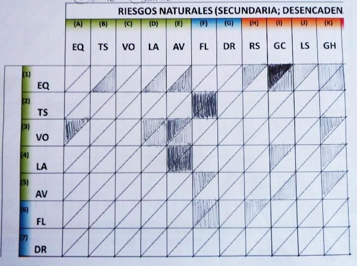
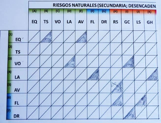
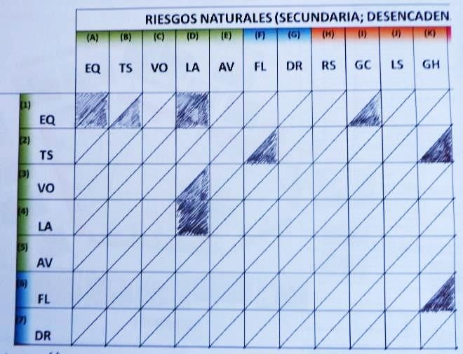
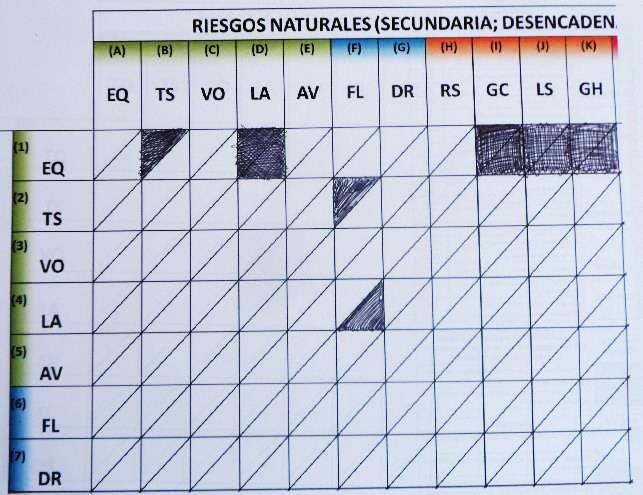
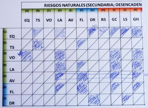
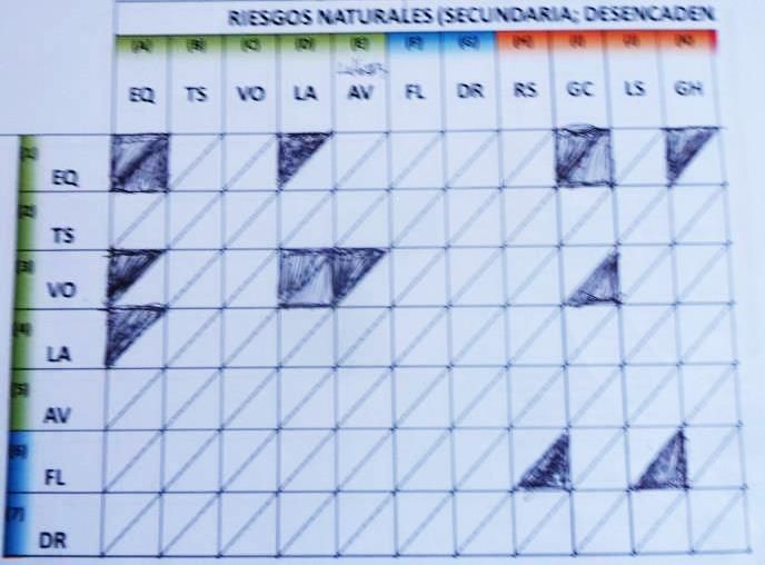
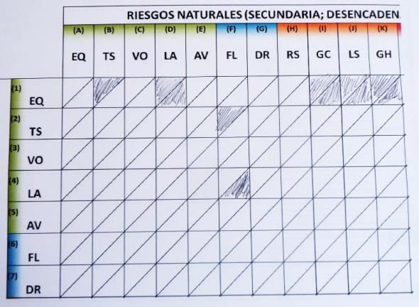
Task 2. 7 × 11 Natural Hazard Interaction Matrix (15 participants). Participants completed a blank hazard interaction
matrix, with seven primary hazards on the vertical axis and eleven secondary hazards on the horizontal axis. In
our second task, 15 participants completed a 7×11 Hazard Interaction Matrix, with seven primary hazards on
the vertical axis and eleven secondary hazards on the horizontal axis. Participants noted both relevant triggering
and increased probability interactions in Guatemala. Completed matrices again show variation in the number
and range of proposed interactions. In Fig. S2, we show 15 hazard matrices, each completed by a different
participant. The number of triggering interactions proposed by any one participant ranged from 3 to 36, with a
mean of 12 and median (50th percentile) of 7. The number of increased probability interactions proposed by
any one participant ranged from 0 to 29, with a mean of 9 and median (50th percentile) of 6. Using all 15
matrices, we develop a representation of the combined knowledge of participants.
We therefore collected two sets of visual records that document participants’ perceptions of relevant hazard interactions in
Guatemala. These are presented in Figs. S1 and S2 of this supplementary material. Using the results of these tasks we can
represent the combined knowledge of the workshop participants (Figs. S3 and S4).
A B C
D E F
Figure S1 figure caption on next page.
<Supplementary Material. Gill et al. Multi-Hazard Regional Interaction Frameworks (NHESS) (version 18 December 2019) Page 12 of 21
G H I
J K L
M N O
P
Figure S1. Stakeholder identification (using network linkage diagram for 21 natural hazards) of possible hazard interactions in Guatemala.
A total of 16 network linkage diagrams (A to P) were completed during a 3-hour workshop on 6 March 2014 by hazard and civil protection
professionals at CONRED.
<Supplementary Material. Gill et al. Multi-Hazard Regional Interaction Frameworks (NHESS) (version 18 December 2019) Page 13 of 21
A B
C D
E F
G H
Figure S2 figure caption on next page.
<Supplementary Material. Gill et al. Multi-Hazard Regional Interaction Frameworks (NHESS) (version 18 December 2019) Page 14 of 21
I J
K L
M N
O
Figure S2. Stakeholder identification (using 7×11 natural hazard interaction matrix) of possible hazard interactions in Guatemala. A total of
15 network linkage diagrams (A to O) were completed on 6 March 2014 during a 3-hour workshop by hazard and civil protection professionals at
CONRED. <Supplementary Material. Gill et al. Multi-Hazard Regional Interaction Frameworks (NHESS) (version 18 December 2019) Page 15 of 21
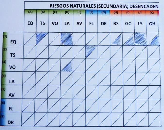
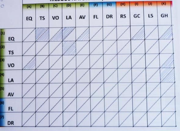
Task 1: Network Linkage Diagram for 21 Hazards
In Fig. S3, we overlay evidence from 16 completed network linkage diagrams on a global interaction framework. Grey
shading indicates those interactions included in the global interaction framework, not all of which are relevant in Guatemala.
Fig. S3, shows the number of participants (out of 16) proposing each triggering relationship.
Figure S3. Stakeholder identification (using the network linkage diagrams presented in Fig. S1 and transferred to the above matrix) of possible
natural hazard interactions in Guatemala. Given is a 21 21 matrix with primary natural hazards on the vertical axis and secondary hazards on the
horizontal axis. These hazards are coded, as explained in the key. These matrices show cases where a primary hazard could trigger a secondary hazard.
Grey cell shading indicates the triggering interactions in the global hazard interaction matrix of Gill and Malamud (2014). Numbers indicate the total
number (from a maximum of 16) of stakeholders proposing each hazard interaction as being possible in Guatemala.
Of a total possible 441 (21×21) interactions, there are 86 different interactions proposed in Fig. S3 as being relevant in
Guatemala (by 1–16 participants), equivalent to 20% of the 441 possible interactions. Consequently, 355 interactions (80%
of the 441 possible interactions) were determined by all 16 participants as not relevant in Guatemala.
Using Fig. S3 we note that for the 86 hazard interactions proposed by ≥1 participant:
2 (2%) were proposed by all 16 participants (100% of the group). These were [earthquake landslide] [storm flood].
3 (3%) were proposed by ≥13 participants (≥ 75% of the group). These were [earthquake landslide] [earthquake ground heave]
[storm flood].
8 (9%) were proposed by ≥ 9 participants (≥ 50% of the group). These were [earthquake landslide] [earthquake ground heave]
[storm flood] [earthquake tsunami] [storm landslide] [storm ground collapse] [extreme temperatures drought] [extreme
temperatures wildfire].
19 (22%) were proposed by ≥ 5 participants (≥ 25% of the group). Additional examples to those noted above include [drought wildfire]
[earthquake regional subsidence] [lightning wildfire].
The remaining 67 (78%) were proposed by 1–4 participants. Examples include [volcanic eruption tsunami] [snowstorm avalanche]
[impact event landslide].
There is strong agreement between participants on ‘no interaction occurs’ (355 of 441 possible interactions), but much greater
variation in agreement on ‘interaction occurs’ (86 of 441 possible interactions). Some of the proposed interactions may not be
relevant (false positives), and others not proposed by participants may be relevant (false negatives) in Guatemala.
<Supplementary Material. Gill et al. Multi-Hazard Regional Interaction Frameworks (NHESS) (version 18 December 2019) Page 16 of 21
Task 2: 7 × 11 Hazard Interaction Matrix
In Fig. S4, we overlay the 15 completed matrices in Fig. S2 on a 7×11 section of a global interaction framework. Grey
shading indicates interactions (triggering or increased probability) included in the global interaction framework, not all of
which are relevant in Guatemala.
A B
Figure S4. Stakeholder identification (using interaction matrix) of possible natural hazard triggering and increased probability interactions
in Guatemala. Two 7 11 matrices with primary natural hazards on the vertical axis and secondary hazards on the horizontal axis. Codes are used
for each hazard type as outlined in Fig. S2, with colour coding for different hazard groups also outlined in Fig. S3. Grey cell shading indicates a
triggering interaction (A) or increased probability interaction (B) existed in the global hazard interaction matrix presented in Gill and Malamud (2014).
Each matrix is then used to represent the total number of stakeholders proposing each hazard interaction as being possible in Guatemala (from Fig.
S2).
Here we show the number of participants (from 15) proposing each triggering relationship (Fig. S4A) and each increased
probability relationship (Fig. S4B). Of a total possible 77 (7×11) triggering relationships, 53 different triggering
relationships (69% of the 77 possible interactions) were proposed to be relevant in Guatemala by ≥1 participant.
Consequently, all participants determined that 24 triggering relationships (32% of the 77 possible interactions) are not
relevant in Guatemala.
Using Fig. S4A we note that of the 53 triggering interactions proposed by ≥1 participant:
None were proposed as being relevant by all 15 participants.
1 (2%) interaction was proposed by ≥13 participants (≥ 87% of the group). This was [earthquake landslide]
6 (11%) were proposed by ≥9 participants (≥ 60% of the group). Examples include [earthquake tsunami] [tsunami flood]
[earthquake ground heave].
13 (25%) were proposed by ≥5 participants (≥ 33% of the group). Additional examples to those noted above include [earthquake regional
subsidence] [volcanic eruption landslide] [landslide ground heave].
The remaining 40 (75%) were proposed by 1–4 participants. Examples include [earthquake volcanic eruption] [landslide flood]
[drought ground collapse].
Of a possible 77 (7×11) increased probability relationships there were 51 different increased probability relationships (66%
of the 77 possible interactions) proposed as being relevant in Guatemala by ≥1 participant. Consequently, all participants
determined that 26 increased probability relationships (34% of the 77 possible interactions) are not relevant in Guatemala.
Using Fig. S4B we note that of the 51 increased probability interactions proposed by ≥1 participant:
None were proposed by ≥13 participants (≥87% of the group).
3 (6%) were proposed by ≥9 participants (≥60% of the group). These were [earthquake landslide] [earthquake ground collapse]
[earthquake ground heave].
7 (14%) were proposed by ≥5 participants (≥ 33% of the group). Additional examples to those noted above include [earthquake soil
(local) subsidence] [volcanic eruption landslide] [landslide landslide] [landslide flood].
44 (86%) were proposed by 1–4 participants. Examples include [earthquake volcanic eruption] [flood landslide] [drought soil
(local) subsidence].
Some of the proposed natural hazard interactions may not be relevant (false positives), and others not proposed by
participants may be relevant (false negatives) in Guatemala.
<Supplementary Material. Gill et al. Multi-Hazard Regional Interaction Frameworks (NHESS) (version 18 December 2019) Page 17 of 21
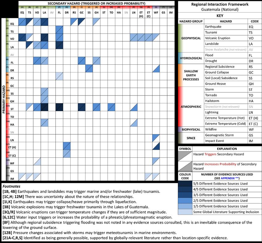
[Associated NHESS Paper] Section 3.3.1 Guatemala National 21×21 Interaction Framework (Matrix Form)
Table S5. Evidence used to populate each cell within the national interaction framework presented in Fig. 3 of the
accompanying paper. Information is presented (mechanism) which describes the physical process by which primary natural
hazards (relevant to Guatemala) trigger, or increases the probability, of secondary natural hazards (relevant to Guatemala).
We note evidence sources used to evidence each interaction, described in detail in Sect. 2 of the accompanying paper.
Evidence
A = International Literature
Primary Secondary Grid B = Civil Protection Bulletins
Generic Mechanism Description
Hazard Hazard ID C = Field Observations
D = Stakeholder Interviews
E = Workshop (≥50% people)
Earthquake Earthquake 1A A primary earthquake causes changes in lithospheric A, D
stresses, leading to aftershocks as the lithosphere responds
to these changes.
Tsunami 1B A rupturing fault line causes the displacement of a large A, D, E
amount of water, triggering a tsunami.
Volcanic 1C Changes in lithospheric stress either (i) reduces confining D
Eruption pressure or (ii) increases pressure within the magma
chamber.
Landslide 1D Seismic shaking results in changes in shear stresses and A, D, E
strength causing the movement of rock and soil material
under gravitational forces.
Regional 1H Vertical displacement caused by faulting results in A, D
Subsidence subsidence on a regional scale.
Ground 1I Liquefaction can result in compression of soils and rapid A, D, E
Collapse downwards movement.
Ground Heave 1K Liquefaction can result in dilation of soils and upwards E
expansion.
Tsunami Flood 2F A tsunami will trigger coastal or lakeshore flooding and A, E
possible fluvial flooding through increased groundwater
and surface run off.
Volcanic Earthquake 3A Injections of magma result in changes in lithospheric A, D, E
Eruption stresses, triggering volcano-tectonic earthquakes.
Tsunami 3B Tsunamis can be as a result of large volcanic explosions A
close to lakes.
Landslide 3D Volcanic activity can either (i) increase shear stress or (ii) A, B, C, E
decrease shear strength, resulting in landslides (flank
instability).
Flood 3F Lava, ash and pyroclastic material can (i) dam waterways, A, D
(ii) block drainage, (iii) melt snow/ice, and thus result in
flooding.
Lightning 3P The collision of ash particles can result in electric discharge D
in the form of lightning.
Extreme 3R/Q The ejection of sulphur into the stratosphere can result in A [if very large eruption]
Temperature both net heating and net cooling.
(Heat/Cold)
Wildfire 3S High temperature lava, ash and pyroclastic material can D
directly trigger wildfires when it comes in contact with
flammable material.
Landslide Tsunami 4B Landslides impacting upon or within water result in the A, C, D
displacement of water, thus triggering a tsunami. These
landslides can be either subaerial or submarine.
<Supplementary Material. Gill et al. Multi-Hazard Regional Interaction Frameworks (NHESS) (version 18 December 2019) Page 18 of 21
Evidence
A = International Literature
Primary Secondary Grid B = Civil Protection Bulletins
Generic Mechanism Description
Hazard Hazard ID C = Field Observations
D = Stakeholder Interviews
E = Workshop (≥50% people)
Volcanic 4C Unloading of a volcano by landslides and flank collapse A
Eruption reduces confining pressures, changing lithospheric stress
and strength conditions. Material input into lava may
trigger the nucleation of bubbles, triggering an eruption.
Landslide 4D A landslide can result in the mobilisation and deposition of A, B
material in another location, increasing the weight on the
head of a slope and promoting instability. The mobilisation
of sediment by landslides can also increase the likelihood
of debris flows in the event of a rainstorm.
Flood 4F Material from landslides can (i) dam waterways, and (ii) A, B, C, D
increase sedimentation in rivers, to promote flooding.
Flood Volcanic 6C Water can trigger or increase the probability of A, D [phreatic, groundwater
Eruption hydromagmatic or phreatomagmatic volcanism. interactions]
Landslide 6D Flood waters can (i) increase groundwater levels and B
therefore pore water pressures, decreasing effective stress,
and (ii) increasing erosion of the slope toe.
Ground 6I Increased water can result in (i) dissolution of salt and B, D
Collapse carbonate deposits, (ii) hydrocompaction of metastable
deposits.
Ground Heave 6K Increased water results in the swelling of clay minerals. A
Drought Soil (Local) 7J Reduced water results in the shrinking of clay minerals and A, D
Subsidence thus local subsidence.
Wildfire 7S Drought results in dry and dead vegetation which increases A, D
the probability of wildfires.
Regional Flood 8F Regional subsidence increases vulnerability to flooding. Not noted in A–E, but if
Subsidence subsidence occurs then an
increased susceptibility to
flooding is inevitable.
Soil (Local) Landslide 10D Local/soil subsidence changes the stress conditions within D
Subsidence slopes.
Ground Heave Landslide 11D Ground heave changes the stress conditions within slopes. D
Storm Tsunami 12B Perturbations in air pressure over the ocean can generate A
large amplitude standing waves.
Volcanic 12C Water can trigger or increase the probability of A, D [phreatic, groundwater
Eruption hydromagmatic or phreatomagmatic volcanism, forming interactions]
small steam explosions or more intense activity.
Landslide 12D Rainwater increases groundwater levels and therefore pore A, B, C, D, E
water pressures, decreasing effective stress.
Flood 12F Heavy rainfall can increase groundwater and surface water A, B, C, D, E
levels - causing flash, fluvial and urban flooding.
Ground 12I Increased water can result in (i) dissolution of salt and A, B, D, E
Collapse carbonate deposits, (ii) hydrocompaction of metastable
deposits.
Ground Heave 12K Increased water results in swelling of clay minerals. A, D
Tornado 12M Tornadoes are produced in hurricanes or tropical storms A, D
due to vertical wind shear.
Lightning 12P The collision of particles can result in electric discharge in A, B
the form of lightning.
<Supplementary Material. Gill et al. Multi-Hazard Regional Interaction Frameworks (NHESS) (version 18 December 2019) Page 19 of 21
Evidence
A = International Literature
Primary Secondary Grid B = Civil Protection Bulletins
Generic Mechanism Description
Hazard Hazard ID C = Field Observations
D = Stakeholder Interviews
E = Workshop (≥50% people)
Hailstorm Landslide 14D Water from hailstorms can increase groundwater levels and D
therefore pore water pressures, decreasing effective stress.
Lightning 14P The collision of ash particles can result in electric discharge A
in the form of lightning.
Lightning Wildfire 16S Lightning discharge can spark fires. D, E
Extreme Drought 17G High temperatures result in an increase in A, E
Temperature evapotranspiration - thus promoting drought conditions.
(Hot)
Wildfire 17S The drying of vegetation by extreme temperatures can A, D, E
result in an increased probability of wildfires.
Extreme Drought 18G Extreme cold conditions can lead to a winter drought when D
Temperature precipitation is in solid rather than liquid form.
(Cold)
Wildfire Landslides 19D Wildfires can remove vegetation, wakening slopes and Supported by globally-
increasing the likelihood of mass movements. relevant literature rather than
location-specific evidence
Wildfire 19S Spotting from wildfires can trigger further wildfires. A
Impact Event Earthquake 21A Impact events can cause major lithospheric disturbance,
including the release of stress as earthquakes.
Tsunami 21B Impact events in water can cause large scale displacement
of water, thus triggering a tsunami.
Identified as being generally
Volcanic 21C Impact events can cause major lithospheric disturbance, possible, supported by
Eruption triggering volcanic eruptions. globally-relevant literature
rather than location-specific
Extreme 21R Impact events can cause large-scale injections of dust and
evidence.
Temperature other particles into the atmosphere - causing widespread
(Cold) cooling effects.
Wildfire 21S Impact events can cause wildfires as super-heated material
touches flammable materials.
<Supplementary Material. Gill et al. Multi-Hazard Regional Interaction Frameworks (NHESS) (version 18 December 2019) Page 20 of 21
In Fig. S5 we give the evidence types used in the construction of a National Interaction Framework for Guatemala. Blue
shading indicates the number of evidence types (A–E) supporting the inclusion of each interaction. Darker shading indicates
inclusion based on more evidence types and lighter shading indicates inclusion based on fewer evidence types. We group
triggering and increased probability interaction types together and indicate the number of evidence types available per
primary hazard-secondary hazard combination. This is due to the coarse resolution of the data used, and complexities of
distinguishing in evidence types between triggered/increased probability interaction types.
Figure S5. Evidence types used in the construction of a National Interaction Framework for Guatemala. A 21×21 matrix with 21 primary
natural hazards on the vertical axis, and 21 secondary natural hazards on the horizontal axis. Interactions (shaded cells) include primary hazards
triggering a secondary hazard, and primary hazards increasing the probability of a secondary hazard. This matrix is populated using different evidence
types, as outlined in Sect. 2 of the accompanying paper. Blue shading indicates the number of evidence types used to populate each matrix cell, as
described in the key. The coarse resolution of the data used, and complexities of distinguishing between triggered/increased probability interaction
types, means we group both interaction types together when indicating the number of evidence types. Visualisation structure based on Gill and
Malamud (2014).
Using Fig. S5 we note that of the 50 identified interactions:
2 (4%) have 5 evidence types to support their inclusion. Examples include [storm landslide] [storm flood].
3 (6%) have 4 evidence types to support their inclusion. Examples include [landslide flood] [storm ground collapse].
6 (12%) have 3 evidence types to support their inclusion. Examples include [earthquake tsunami] [landslide tsunami] [extreme
temperatures (heat) wildfire].
15 (30%) have 2 evidence types to support their inclusion. Examples include [tsunami flood] [drought soil subsidence]
[storm ground heave].
17 (34%) have 1 evidence types to support their inclusion. Examples include [earthquake volcanic eruption] [flood landslide]
[storm tsunami].
7 (14%) are included due to globally relevant literature, rather than Guatemala-specific literature. Examples include [impact
event landslide] [regional subsidence flood].
<Supplementary Material. Gill et al. Multi-Hazard Regional Interaction Frameworks (NHESS) (version 18 December 2019) Page 21 of 21
[Associated NHESS Paper] Section 3.5 Anthropogenic Processes
Table S6. Relevant anthropogenic process types in Guatemala. A description of the four evidence types A–E, together with additional references,
used to identify 17 anthropogenic process types as being spatially relevant in Guatemala.
Evidence
A = International Literature
B = Civil Protection Bulletins
Anthropogenic Process Type C = Field Observations
D = Stakeholder Interviews
E = Workshop (anthropogenic processes not discussed)
* (Reference) = Additional citations, beyond A–E.
Groundwater Abstraction D
Oil/Gas Extraction * (OEC, 2016)
Subsurface Infrastructure Construction A D
Subsurface Mining * (OEC, 2016)
Material (Fluid) Injection * (USGeothermal, 2016)
Vegetation Removal A C D
Agricultural Practice Change C D
Urbanisation C D
Infrastructure Construction (Unloading) D
Quarrying/Surface Mining (Unloading) * (OEC, 2016)
Infrastructure (Loading) C D
Infilled (Made) Ground A
Reservoir and Dam Construction A D * (Salini Impregilo, 2014)
Drainage and Dewatering A B D
Water Addition A B D
Chemical Explosion Inferred relevant
Fire D
OEC (Observatory of Economic Complexity): Economic Complexity of Guatemala [online] Available at:
http://atlas.media.mit.edu/en/profile/country/gtm/ (accessed 29 November 2018), 2016.
Salini Impregilo: Pueblo Viejo Dam on the Chixoy river [online] Available at: http://www.salini-impregilo.com/en/projects/completed/dams-
hydroelectric-plants/pueblo-viejo-dam-on-the-chixoy-river.html (accessed 29 November 2018), 2014.
USGeothermal: El Ceibillo Geothermal Project Overview [online] Available at: http://www.usgeothermal.com/projects/4/El%20Ceibillo%20-
%20Guatemala (accessed 29 November 2018), 2016.You can also read