Terrestrial or Planetary wind systems
←
→
Page content transcription
If your browser does not render page correctly, please read the page content below
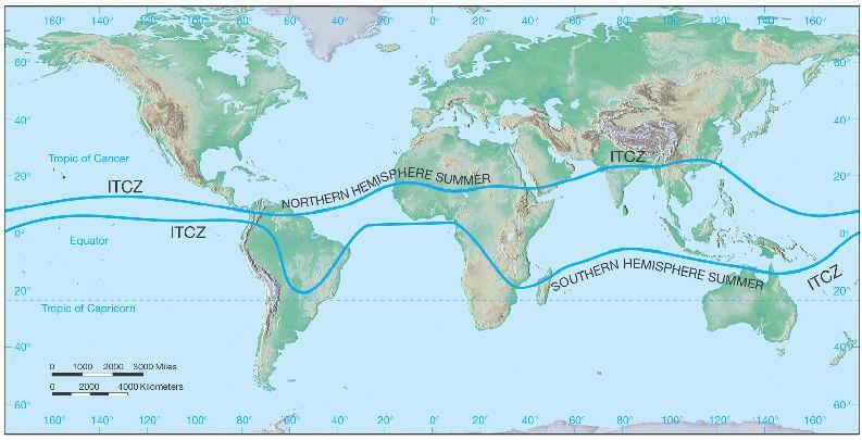
Terrestrial or Planetary wind systems

Introduction

Heating of the earth by the sun is not uniform; the equatorial regions receive much more heat than the poles.
The belt of maximum insolation or the thermal equator moves north-south corresponding to the apparent
movement of the sun. Heat is transported from the equator to the poles to achieve heat balance. This is done
mainly through atmospheric circulation and to some extent through ocean currents. In the equatorial regions,
warm air rises up and moves equtorward. Air streams and ocean waters moving north or south undergo
deflection due to earth’s rotation. The flow turns left or right depending on the direction of motion, rendering
the stream westerly or easterly as the case may be. This is termed coriolis force and the magnitude of the
coriolis deflection is governed by the latitude. The heat transport to establish global heat balance results in a
definite pattern of pressure and winds.

Pressure and Wind Systems

A low pressure belt covers the equatorial region, roughly between latitudes 10˚ north and south. This
equatorial low pressure area, also known as doldrums, is characterized by weak winds and sudden storms.
The doldrums is an area of calm weather. The trade winds coming from the south and the north meet near the
equator. These converging trade winds produce general upward winds as they are heated so there are no steady
surface winds. Air from both the hemispheres converges in this low, giving rise to the inter-tropical
convergence zone (ITCZ). Warm moist air which accumulates in this zone rises up resulting in convective
clouds and thundersqualls at many places along the ITCZ. The rising air moves towards the poles north and
south. Part of this air sinks around latitude 30˚ N and S forming subtropical highs (STH) in the two
hemispheres.
Air diverges at the surface from the STHs. The diverging air moves equatorward, undergoes deflection due
to the earth’s rotation and becomes northeast trade winds and southeast trade winds. These winds were of
immense help to the sail ships of olden days to facilitate trade and that is how the name trade winds came.
Part of the diverging air from the STHs moves polewards. After deflection due to coriolis force they become
middle latitude westerlies. They become quite strong in the higher latitudes and are sometimes referred to as
roaring forties. At the upper levels, air reaching the poles subsides and gives rise to the polar highs (PH) at
the surface. Air flows and becomes polar easterlies. Middle latitude westerlies and polar easterlies, moving
side by side, interact resulting in a semi permanent polar front (PF). A number of lows form on this front and
move from west to east causing unsettled weather.

                        DOLDRUMS                                                ITCZ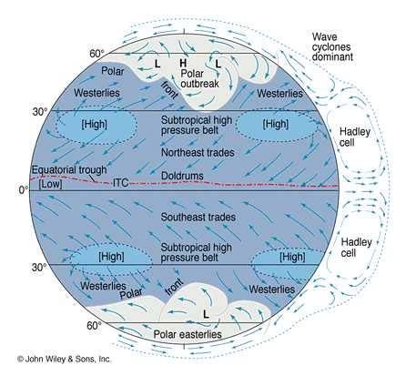
General Circulation
The long term averaged picture shows three major wind systems in the two hemispheres at
the surface,
Northeast/southeast trade winds in the tropics
Westerlies in the middle latitudes
Easterlies in the polar regions.
The broad latitudinal or zonal currents show wave motion and are fairly deep, extending at
times up to the tropopause. These are long waves which span thousands of kilometers and have
a life span of one or two weeks. There are small circulations, hundreds to thousand kilometers
in extent with a life cycle of days, embedded within the long waves. These are the synoptic
scale systems seen as lows, cyclones, highs, etc and constitute the actual weather-producing
atmospheric systems. Within these are still smaller meso scale systems such as thunderstorms
and sea breeze circulations extending over tens of kilometers and lasting some hours. Lower
down the scale are still smaller micro scale circulations spanning a kilometer and down to a
few centimeters, lasting several minutes. Examples are circulations and processes close to the
ground such as eddies, diffusion and turbulence which modify the ecosystem and are of
importance to living organisms.
The above hierarchy of circulations, each with its own typical dimension and life cycle,
constitutes the general circulation. The synoptic scale circulations are mainly responsible for
the latitudinal or meridional transfer of heat from equator to poles. The zonal pressure and wind
belts oscillate north and south in consonance with the seasonal movement of the sun.
Simultaneously the ITCZ and PF also shift north and south.
SUB TROPICAL HIGHS or SEMI PERMANENT POLAR FRONTS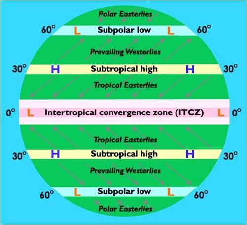
TRADE WINDS

WESTERLIES AND POLAR HIGHS
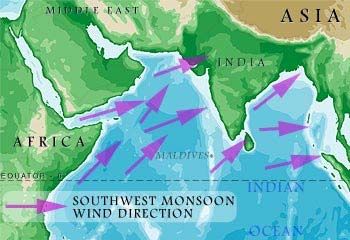
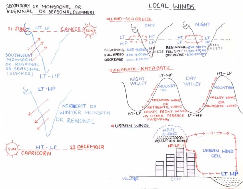
Southwest and Northeast monsoon

Southwest Monsoon

During summer, a high pressure area lies over the Indian Ocean. Meanwhile an intense low
pressure area forms over the northwest parts of the Indian subcontinent and this gradually
extends as a trough across the Indo-Gangetic plains to the head of the Bay of Bengal. The air
moves from high pressure are to low pressure area i.e from Indian ocean to northwest parts of
Indian subcontinent, cross the equator and deflected to the right due to the earth's rotation and
advance further north as a south-westerltystream. The southwesterly current reaches Kerala
and the Bengal coasts by the beginning of June. This is the summer southwest monsoon. The
current flows further east as the southeast monsoon of China and Japan. The entire system
constitutes the Asiatic monsoon. The monsoon current is 1 to 3km deep.

The first place of onset of the southwest monsoon is south Kerala and the date of this onset is
watched with great interest all over the country. Life and economy of the entire country is
dependent on the behaviour of this monsoon. The actual date of onset shows wide variations
from year to year. The normal date of onset over south Kerala is 1st June. The southwest
monsoon current advances northwards in two branches-the Arabian Sea branch and the Bay of
Bengal branch. The Himalayan range restricts its spread northward.

Northeast Monsoon

An intense high pressure area builds up over Central Asia by December. Meanwhile a low
pressure area lies over the south Indian Ocean. The air flows from the Central Asian high
towards the Indian Ocean low. Starting as the northwest monsoon of China, this air flows
southwards as the northeast monsoon of South Asia. Crossing the equator, the current is
deflected due to the Coriolis force and reaches Australia as the northwest monsoon there. The
northeast monsoon which is the winter component of the Asiatic monsoon prevails over India
from December to February.
You can also read