The 4.2 ka BP event: multi-proxy records from a closed lake in the northern margin of the East Asian summer monsoon - Climate of the Past
←
→
Page content transcription
If your browser does not render page correctly, please read the page content below
Clim. Past, 14, 1417–1425, 2018
https://doi.org/10.5194/cp-14-1417-2018
© Author(s) 2018. This work is distributed under
the Creative Commons Attribution 4.0 License.

The 4.2 ka BP event: multi-proxy records from a closed lake in
the northern margin of the East Asian summer monsoon
Jule Xiao1,2,3 , Shengrui Zhang1 , Jiawei Fan1 , Ruilin Wen1,2 , Dayou Zhai4 , Zhiping Tian5 , and Dabang Jiang5
1 CAS  Key Laboratory of Cenozoic Geology and Environment, Institute of Geology and Geophysics,
Chinese Academy of Sciences, Beijing 100029, China
2 CAS Center for Excellence in Life and Paleoenvironment, Beijing 100044, China
3 College of Earth and Planetary Sciences, University of Chinese Academy of Sciences, Beijing 100049, China
4 Yunnan Key Laboratory for Palaeobiology, Yunnan University, Kunming 650091, China
5 Nansen-Zhu International Research Centre, Institute of Atmospheric Physics, Chinese Academy of Sciences,

Beijing 100029, China

Correspondence: Jule Xiao (jlxiao@mail.iggcas.ac.cn)

Received: 10 June 2018 – Discussion started: 18 June 2018
Revised: 7 September 2018 – Accepted: 18 September 2018 – Published: 11 October 2018

Abstract. The 4.2 ka BP event has been widely investigated        ened EASM and thus decreased rainfall in the northern mar-
since it was suggested to be a possible cause for the col-        gin of the EASM.
lapse of ancient civilizations. With the growth of proxy
records for decades, however, both its nature and its spa-
tial pattern have become controversial. Here we examined
multi-proxy data of the grain-size distribution, ostracode as-    1   Introduction
semblage, pollen assemblage, and the pollen-reconstructed
mean annual precipitation from a sediment core at Hulun           In the early 1990s, Weiss et al. (1993) identified a marked
Lake in northeastern Inner Mongolia spanning the period be-       increase in aridity and wind circulation occurring in northern
tween 5000 and 3000 cal. yr BP to identify the nature and         Mesopotamia at 2200 BC based on studies of archaeologi-
the associated mechanism of the 4.2 ka BP event occurring in      cal sites on alluvial plains of the Tigris and Euphrates rivers,
the monsoonal region of eastern Asia. Higher sand fraction        suggesting that the abrupt climatic change induced a con-
contents, littoral ostracode abundances, and Chenopodiaceae       siderable degradation of land-use conditions and thus caused
pollen percentages together with lower mean annual precip-        the collapse of the rain-fed agriculture civilization of west-
itation reveal a significant dry event at the interval of 4210–   ern Asia. Years later, two articles published in the periodi-
3840 cal. yr BP that could be a regional manifestation of the     cal “Science” (Weiss and Bradley, 2001; deMenocal, 2001)
4.2 ka BP event in the northern margin of the East Asian sum-     demonstrated that the drought that occurred 4.2 ka ago could
mer monsoon (EASM). We suggest that the drought would             be a possible cause for the collapse of ancient civilizations,
be caused by a decline in the intensity of the EASM on            which promoted extensive investigations into the abrupt cli-
millennial-to-centennial scales that could be physically re-      matic change occurring around 4.2 ka BP and the causal re-
lated to persistent cooling of surface waters in the western      lationship between the cultural collapse and the 4.2 ka BP
tropical Pacific and the North Atlantic. The cooling of west-     event.
ern tropical Pacific surface waters could reduce moisture pro-       The Holocene climatic instability has actually become a
duction over the source area of the EASM, while the cooling       hot topic of paleoclimate research since the 1990s. Unfor-
of North Atlantic surface waters could suppress northward         tunately no clear signals of the 4.2 ka BP event were identi-
migrations of the EASM rain belt, both leading to a weak-         fied from the proxies of Greenland ice-core records, includ-
                                                                  ing oxygen isotope composition (Dansgaard et al., 1993), sea
                                                                  salt and terrestrial dust concentrations (O’Brien et al., 1995),

Published by Copernicus Publications on behalf of the European Geosciences Union.
1418 J. Xiao et al.: The 4.2 ka BP event: multi-proxy records
and accumulation rate, temperature, and chloride, calcium,
and methane concentrations (Alley et al., 1997). Although a MANCHURIA
1
series of abrupt shifts were detected for the Holocene climate
of the North Atlantic through an investigation of ice-rafted 2
3
debris in the deep-sea sediments, the 4.2 ka BP event appears
unexceptional (Bond et al., 1997). These data imply that the CHINA
4.2 ka BP event could be more complicated than previously 49°20'
recognized. Despite the attempts made over the years, in fact,
the nature of the 4.2 ka BP event itself remains controversial EASM
(Marchant and Hooghiemstra, 2004; Magny et al., 2009), es-
pecially its impact on prehistoric cultures (Drysdale et al.,
Red Flag Fishery HL06
2006; Staubwasser and Weiss, 2006).
Research on the 4.2 ka BP event and its impact on cul-
5
tural evolution in China have been motivated by Hsü’s view
that famines and mass migrations occurring in ancient China 49°00'
could have resulted from regional droughts related to global
cooling (Hsü, 1998). Wu and Liu (2004) synthesized data
from paleoclimatic records in eastern China and suggested
that the climatic anomaly that occurred ∼ 4.2 ka ago pro-
duced a drought in the north and flooding in the south, which
4
was responsible for the collapse of neolithic cultures in the 3
central plain of China during the late third millennium BC. 2
NEW BARAG
RIGHT BANNER 1
Liu and Feng (2012) recently examined the newly published 48°40'
data of paleoclimatic and archaeological records spanning
the transition from the middle to late Holocene and offered
0 10 km
a different interpretation from that of Wu and Liu (2004). In 117°00' 117°30'
brief, an abrupt climatic shift occurred in northern China at
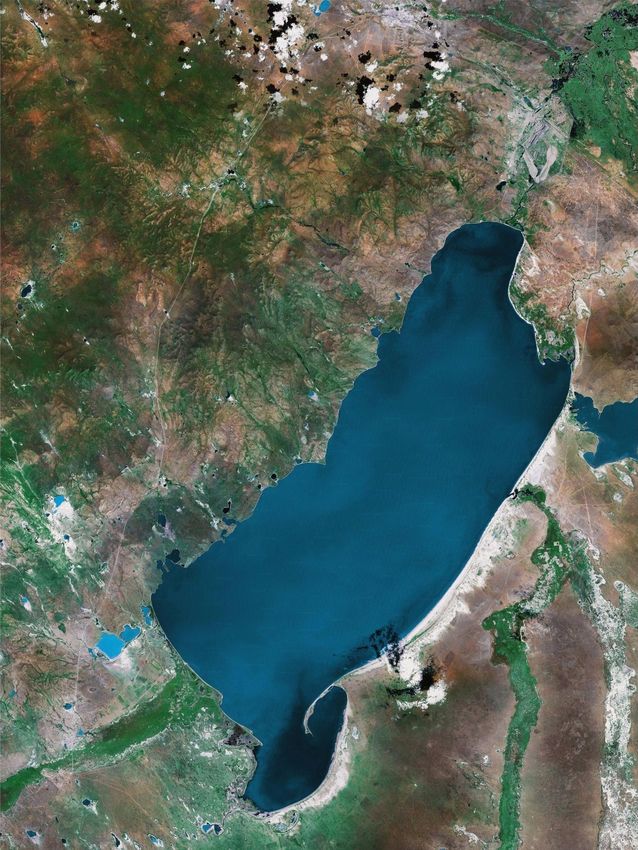
∼ 4 cal. ka BP, while in southern China the ∼ 4 ka BP event Figure 1. Map of Hulun Lake (from https://www.arcgis.com/home/
had several effects. With the associated climatic drying at item.html?id=474c65ab3e1941468511785495eb8987, last access:
∼ 4 cal. ka BP, Chinese neolithic cultures both in the north 6 June 2018) showing the location of the HL06 core. A bathy-
and in the south collapsed, while the Longshan culture in the metric survey of the lake was conducted in July 2005 with an FE-
central plain thrived. 606 Furuno echo sounder (contours in meters). The inset gives a
Here we examine the paleoclimatic data from a sediment sketch map of China showing the current northern limit of the East
Asian summer monsoon (dashed line) defined as the 400 mm iso-
core at Hulun Lake in northeastern Inner Mongolia and fo-
hyet of mean annual precipitation (Chinese Academy of Sciences,
cus on the 4.2 ka BP event occurring in the lake region. Hulun 1984; Zhang and Lin, 1985) and the locations of the lakes (solid
Lake is located in the northern margin of the East Asian sum- circles) mentioned in the present study. (1) Hulun Lake; (2) Dali
mer monsoon that represents a climatically sensitive zone. Lake; (3) Daihai Lake. EASM in the inset indicates the East Asian
The multi-proxy paleoclimatic records from the lake could summer monsoon.
provide new insights into the 4.2 ka BP event. This study is
aimed at identifying the nature and the associated mechanism
of the 4.2 ka BP event occurring in the monsoonal region of tains and hills of Mesozoic volcanic rocks border the lake on
eastern Asia. the northwest and form a fault-scarp shoreline. Broad lacus-
trine and alluvial plains extend from the southern and east-
ern shores of the lake with scattered aeolian dunes. The lake
2 Study site has a catchment of 37 214 km2 within the borders of China.
Two rivers, the Herlun from the southwest and the Urshen
Hulun Lake (48◦ 30.6670 to 49◦ 20.6670 N, 117◦ 0.1670 to from the southeast, supply water for the lake (Fig. 1). The
117◦ 41.6670 E), the fifth largest lake in China, is situated Dalanolom River, an intermittent river to the northeast of the
about 30 km south of Manchuria, Inner Mongolia, China lake, drains the lake when the elevation of the lake level ex-
(Fig. 1). It lies in an inland graben basin that was formed in ceeds 543.4 m a.s.l. and enters the lake when the lake level is
the late Pliocene (Xu et al., 1989). It has an area of 2339 km2 lower and the discharge of the Hailar River is larger as well
and a maximum water depth of 8 m when the lake level is (Xu et al., 1989) (Fig. 1).
highest at an elevation of 545.3 m a.s.l. (measurements in Hulun Lake is located in a semi-arid area of the middle
August 1964; Xu et al., 1989). Today, the lake is closed temperate zone (Fig. 1). The climate of the lake region is
and the maximum water depth is 5 m (Fig. 1). Low moun- influenced by the East Asian monsoon and the westerlies
Clim. Past, 14, 1417–1425, 2018 www.clim-past.net/14/1417/2018/J. Xiao et al.: The 4.2 ka BP event: multi-proxy records 1419
(Chinese Academy of Sciences, 1984; Zhang and Lin, 1985). mass spectrometry (AMS) system (compact AMS, NEC Pel-
During summer, warm, moist southerly air masses interact letron) at Paleo Labo Co., Ltd. in Japan. As shown in Xiao et
with cold air from the northwest and produce most of the al. (2009), the uppermost 0–1 cm of the core sediments yields
annual precipitation. During winter, cold, dry northwesterly a 14 C age of 685±21 years that was considered to result from
airflows prevail and generate strong winds and cold weather. carbon reservoir effects on radiocarbon dating of the bulk or-
In the lake region, mean annual temperature is 0.3 ◦ C with a ganic matter of Hulun Lake sediments. To produce an age–
July average of 20.3 ◦ C and a January average of −21.2 ◦ C. depth model for the HL06 core, the carbon reservoir age of
Annual precipitation is 247 to 319 mm, and over 80 % of the 685 ± 21 years was first subtracted from all the original 14 C
annual precipitation falls in June–September. Annual evap- ages, and then calibrations were performed on the carbon-
oration reaches 1400 to 1900 mm. The lake is covered with reservoir-free 14 C ages. The conventional ages were con-
∼ 1 m of ice from November to April. verted to calibrated ages using the OxCal3.1 radiocarbon age
The ostracodes living in the lake today include Lim- calibration program (Bronk Ramsey, 2001) with the IntCal04
nocythere inopinata (Baird), Candoniella suzini Schnei- calibration data (Reimer et al., 2004). The age–depth model
der, Pseudocandona albicans (Brady), Pseudocandona com- indicates that the HL06 core covers the last ∼ 11 000 years
pressa (Koch),Cyclocypris serena (Koch), Ilyocypris gibba (Xiao et al., 2009).
(Ramdohr), and Ilyocypris salebrosa Stepanaiths (Xu et al.,
1989; Wang and Ji, 1995). Limnocythere inopinata is the
dominant species. Aquatic plants are scarce in the lake and 3.2 Proxy analyses of the HL06 core
confined to the areas of the river mouth and parts of the
nearshore zone. The HL06 core has been analyzed at 1 cm intervals for mul-
The modern natural vegetation of the lake basin belongs tiple proxies, including grain-size distribution (Xiao et al.,
to the middle temperate steppe (Compilatory Commission of 2009), ostracode assemblage (Zhai et al., 2011), and pollen
Vegetation of China, 1980; Xu et al., 1989). The vegetation assemblage (Wen et al., 2010a), in order to investigate the
cover ranges from relatively moist forb grass meadow steppe Holocene history of changes in the hydrology of Hulun Lake
in the piedmont belt to moderately dry grass steppe on the al- and in the vegetation and climate of the lake region. Grain-
luvial plain and dry bunchgrass–undershrub Artemisia steppe size distribution was determined with a Malvern Mastersizer
on the lacustrine plain. Halophilic Chenopodiaceae plants are 2000 laser grain-size analyzer (Xiao et al., 2009). Each sam-
distributed in the lowlands. The forests are developed on the ple of sediment was pretreated with hydrogen peroxide to
west slopes of the Great Hinggan Range, where the Urshen remove organic matter and then with boiled hydrochloric
and Hailar River rise, accompanied by scrubs and herbs un- acid to remove carbonates. The sample residue was dispersed
der the trees. Larch forests cover the southern part of the with sodium metaphosphate on an ultrasonic vibrator before
Hentiy Mountains where the Herlun River rises. Patches of grain-size analysis.
pine forests and birch shrubberies occur in the alpine belt. For the ostracode assemblage analysis, each sample of
∼ 300 mg of air-dried sediment was pretreated with hydro-
gen peroxide–sodium carbonate solution (pH 9–10) to dis-
3 Material and methods
aggregate the sediment (Zhai et al., 2011). Fossil ostracode
3.1 Lithology and chronology of the HL06 core
valves were extracted by sieving in water through a 250-
mesh sieve (63 µm pore size). Ostracode was identified and
Drilling was conducted at a water depth of 5 m in the central counted from the sieve residue spread onto a glass plate with
part of Hulun Lake in January 2006 when the lake was frozen an Olympus stereomicroscope at 40 × magnification follow-
(Fig. 1) using a TOHO drilling system. A sediment core was ing the taxonomy of Meisch (2000) and Hou et al. (2002).
extracted to a depth beneath the lake floor of 1.7 m and is Most samples yielded 300 to 4000 ostracode valves.
designated HL06 (49◦ 07.6150 N, 117◦ 30.3560 E; Fig. 1). The For the pollen assemblage analysis, each sample of ∼ 1 g
core section was split, photographed, and described on-site; of air-dried sediment was pretreated with hydrochloric acid
it was then cut into 1 cm segments, resulting in 170 samples to remove carbonates and with sodium hydroxide to remove
for laboratory analyses. organic matter; the residue was then kept in hydrofluoric acid
The sediments of the HL06 core can be divided into three to remove silicates (Wen et al., 2010a). Fossil pollen grains
parts: (1) upper blackish grey oozy mud at depths of 0– were extracted by wet sieving of the resulting residue through
35 cm, (2) middle dark grey to blackish grey, massive sandy a sieve diameter of 10 µm with an ultrasonic cleaner. Pollen
mud with scattered fragments of ostracodes and mollusk was identified and counted with an Olympus light micro-
shells at depths of 35–100 cm, and (3) lower greenish grey scope at 400 × magnification. More than 600 pollen grains
homogeneous mud at depths of 100–170 cm (Xiao et al., were counted for each sample. The percentages of tree and
2009). herb pollen taxa were based on the sum of the total terrestrial
A total of 13 bulk samples were collected from organic- pollen in a sample, and those of each taxon of both aquatic
rich horizons of the HL06 core and dated with an accelerator pollen and fern spores based on the sum of the terrestrial
www.clim-past.net/14/1417/2018/ Clim. Past, 14, 1417–1425, 20181420 J. Xiao et al.: The 4.2 ka BP event: multi-proxy records
Lithology Age (cal yr BP) der to explore the detailed process of climate changes on
2500 3500 4500 5500
55 millennial-to-centennial scales in the Hulun Lake region
around 4.2 cal. ka BP.
65
4 Results
The sediments of the core segment spanning the period of
Depth in core (cm)
75
5000–3000 cal. yr BP consist of dark grey to blackish grey,
massive sandy mud in which the scattered fragments of ostra-
code and mollusk shells can be seen (Fig. 2). Five radiocar-
85
bon dates provide age controls for the core segment spanning
the period of 5000–3000 cal. yr BP (corresponding to the
95
core depths of 97–68 cm) (Fig. 2; Table 1). Data of sand frac-
tion content, littoral ostracode abundance, Chenopodiaceae
pollen percentage, and mean annual precipitation from the
105
core segment spanning the period of 5000–3000 cal. yr BP
Mud
Sandy
mud
Shell
fragments
were plotted against age in Fig. 3. The average and 1 stan-
dard deviation (SD) values for all proxy data for the period
Figure 2. Lithological log and age–depth model of the segment of between 5000 and 3000 cal. yr BP are expressed.
the HL06 core between 105 and 55 cm at core depth (covering the As shown in Fig. 3, the content of the sand fraction
period between 5000 and 3000 cal. yr BP). Solid circles represent in the core sediments has an average of 7.5 % and SD of
the mean values of 2σ ranges of calibrated ages of carbon-reservoir- 6.3 % for the period of 5000–3000 cal. yr BP. At the in-
corrected radiocarbon dates. The carbon reservoir correction factor terval of 4430–3860 cal. yr BP (core depth: 91–83 cm), the
is 685±21 years, which is the 14 C age of the uppermost 1 cm of the sand fraction content shows values higher than 1 SD with a
core sediments. Modified after Xiao et al. (2009).
maximum of 21.1 % and an average of 15.5 %. The abun-
dance of the littoral ostracodes including Pseudocandona
albicans, Pseudocandona spp., Candoniella subellipsoidea,
pollen plus the aquatic pollen or fern spores of the taxon in a
and Cypridopsis spp. from the core sediments has an av-
sample.
erage of 22 valves g−1 and SD of 22 valves g−1 for the
In addition, the history of changes in precipitation in the
period of 5000–3000 cal. yr BP. At the interval of 4200–
Hulun Lake region during the Holocene was quantitatively
3420 cal. yr BP (core depth: 88–76 cm), the littoral ostracode
reconstructed (Wen et al., 2010b) based on the pollen pro-
abundance shows values higher than 1 SD with a maximum
file of the HL06 core (Wen et al., 2010a), using a pollen–
of 70 valves g−1 and an average of 44 valves g−1 . The per-
climate transfer function for temperate eastern Asia (Wen et
centage of Chenopodiaceae pollen from the core sediments
al., 2013).
has an average of 42.9 % and SD of 10.7 % for the period of
5000–3000 cal. yr BP. At the interval of 4300–3830 cal. yr BP
3.3 Proxy data from the HL06 core used (core depth: 89–83 cm), the Chenopodiaceae pollen percent-
for the present study age shows values higher than 1 SD with a maximum of
60.2 % and an average of 56.5 %. The mean annual precip-
The segment of the HL06 core spanning the period between itation in the lake region reconstructed on the pollen profile
5000 and 3000 cal. yr BP is used for the present study to of the sediment core has an average of 297.3 mm and SD of
focus on the 4.2 ka BP event occurring in the Hulun Lake 20.3 mm for the period of 5000–3000 cal. yr BP. At the in-
region. Figure 2 shows the lithology and ages of the core terval of 4240–3750 cal. yr BP (core depth: 88–82 cm), the
segment between 105 and 55 cm at depth, which covers the mean annual precipitation shows values lower than 1 SD with
segment between dated horizons of a calibrated age older a minimum of 264.0 mm and an average of 272.3 mm.
than 5000 cal. yr BP and of a calibrated age younger than
3000 cal. yr BP. Ages of sampled horizons of the core seg-
5 Discussion
ment spanning the period of 5000–3000 cal. yr BP were de-
rived by linear interpolation between radiocarbon-dated hori-
5.1 Climatic implication of proxy data from
zons using the mean values of 2σ ranges of calibrated ages.
the HL06 core
Data of grain-size distribution (Xiao et al., 2009), os-
tracode assemblage (Zhai et al., 2011), pollen assemblage Grain-size distributions of the core sediments show that the
(Wen et al., 2010a), and mean annual precipitation (Wen clay, silt, and sand fractions average 35.8 %, 60.6 %, and
et al., 2010b) from the HL06 core for the period of 5000– 3.6 % of the clastic materials during the Holocene, respec-
3000 cal. yr BP were reexamined in the present study in or- tively (Xiao et al., 2009). Sand grains from the nearshore
Clim. Past, 14, 1417–1425, 2018 www.clim-past.net/14/1417/2018/J. Xiao et al.: The 4.2 ka BP event: multi-proxy records 1421
Sand fraction Littoral ostracode Chenopodiaceae Mean annual precipitation PCA F1
(%) (valves g‒1) (%) (mm)
0 8 16 24 0 20 40 60 80 20 30 40 50 60 70 250 280 310 340 ‒2 ‒1 0 1 2
3000
Age (cal yr BP)
4000
5000
Figure 3. Time series of sand fraction (%) (Xiao et al., 2009), littoral ostracode valves (valves g−1 ) (Zhai et al., 2011), Chenopodiaceae
pollen (%) (Wen et al., 2010a), and mean annual precipitation (mm) (Wen et al., 2010b) from the HL06 core spanning the period between
5000 and 3000 cal. yr BP as well as the PCA F1 obtained from the aforementioned four proxies. The chronology was derived from the carbon-
reservoir-corrected age–depth model; ages of sampled horizons were determined by linear interpolation between radiocarbon-dated horizons
using the mean values of 2σ ranges of calibrated ages (Xiao et al., 2009). Vertical dashed lines show the averages and 1 standard deviations
above and below the averages of each proxy data as well as PCA F1 values during the period between 5000 and 3000 cal. yr BP. Light grey
bars mark the intervals at which each proxy or PCA F1 has values higher than 1 standard deviation (lower than 1 standard deviation for mean
annual precipitation).
Table 1. AMS radiocarbon dates of samples from the segment of the HL06 core between 105 and 55 cm at core depth (covering the period
between 5000 and 3000 cal. yr BP). The radiocarbon date of the uppermost 1 cm of the core sediments used for carbon reservoir correction is
shown. Modified after Xiao et al. (2009).
Laboratory Depth interval Dating δ 13 C (‰) AMS 14 C age Corrected 14 C ageb Calibrated 14 C age
numbera (cm) material (14 C yr BP) (14 C yr BP) (2σ ) (cal yr BP)
PLD-7489 0–1 Organic matter −26.94 685 ± 21 0 ± 30 0–10
PLD-7925 59–60 Organic matter −26.57 3222 ± 29 2537 ± 36 2480–2650
PLD-7495 69–70 Organic matter −27.73 3630 ± 27 2945 ± 34 2970–3220
PLD-7926 79–80 Organic matter −26.72 4034 ± 30 3349 ± 37 3470–3690
PLD-7927 89–90 Organic matter −25.40 4575 ± 31 3890 ± 37 4230–4430
PLD-7496 101–102 Organic matter −28.38 5304 ± 27 4619 ± 34 5290–5470
a Laboratory code of Paleo Labo Co., Ltd., Japan. b The reservoir correction factor is 685 ± 21 years, which is the 14 C age of the uppermost 1 cm of the core
sediments.
zone of Hulun Lake could be transported to and deposited interpreted as littoral ostracode taxa because these ostra-
in the central part of the lake when the lake level was low. codes usually live in small water bodies and shallow wa-
Therefore, increases in the relative percentage of the sand ters and have a wide tolerance for water temperature and
fraction in the core sediments were interpreted to indicate salinity (Zhai et al., 2011). We thus infer that higher values
drops in the water level of Hulun Lake (Xiao et al., 2009). of the littoral ostracode abundance at the interval of 4200–
We thus infer that higher values of the sand fraction content 3420 cal. yr BP imply lower lake levels at that time (Fig. 3).
at the interval of 4430–3860 cal. yr BP imply lower lake lev- Pollen assemblages of the core sediments suggest that
els at that time (Fig. 3). dry grass steppe dominated by Artemisia and Chenopodi-
Ostracode assemblages of the core sediments suggest that aceae plants were developed in the Hulun Lake basin dur-
14 species of ostracodes belonging to nine genera occur ing most of the Holocene (Wen et al., 2010a). In the mod-
in Hulun Lake during the Holocene and Limnocythere in- ern steppe of northern China, Chenopodiaceae predominates
opinata is the dominant species (Zhai et al., 2011). Pseudo- over Artemisia in desert steppe compared with typical steppe.
candona albicans, Pseudocandona spp., Candoniella subel- Therefore, increases in the relative percentage of Chenopo-
lipsoidea, and Cypridopsis spp. from the core sediments were diaceae pollen in the core sediments were interpreted to in-
www.clim-past.net/14/1417/2018/ Clim. Past, 14, 1417–1425, 20181422 J. Xiao et al.: The 4.2 ka BP event: multi-proxy records
dicate decreases in the effective moisture in the lake basin Hulun Lake region that started at 4210 cal. yr BP and ended
(Wen et al., 2010a). We thus infer that higher values of the at 3840 cal. yr BP, lasting for 370 years.
Chenopodiaceae pollen percentage at the interval of 4300– Studies on carbon concentrations of a sediment core at
3830 cal. yr BP imply lower effective moisture in the lake Dali Lake, south of Hulun Lake (see Fig. 1), reveal obvi-
basin at that time (Fig. 3). ous decreases in total organic carbon concentration at 4450–
The pollen-reconstructed mean annual precipitation yields 3750 cal. yr BP, indicating a major interval of low lake stands
a value of around 285 mm in the Hulun Lake region for the and dry climatic conditions during the Holocene (Xiao et al.,
last decades (Wen et al., 2010b). This value of the mean 2008). Moreover, a recent synthesis of grain-size distribu-
annual precipitation falls within the range of observed data tion, carbon concentration, pollen assemblage, and pollen-
of the annual precipitation (247–319 mm), demonstrating the reconstructed precipitation from a sediment core at Daihai
validity of the pollen–climate transfer function in quantita- Lake, southwest of Hulun Lake (see Fig. 1), reflects a drought
tively reconstructing the regional precipitation. Therefore, at 4060–3690 cal. yr BP (Xiao et al., 2018). These data lend
lower values of the mean annual precipitation at the interval support, within age uncertainties, to the inference of a dry
of 4240–3750 cal. yr BP denote drier conditions in the lake event occurring in the Hulun Lake region in the present study.
basin at that time (Fig. 3). We thus suggest that the dry event that occurred in the Hu-
lun Lake region at 4210–3840 cal. yr BP could be the regional
manifestation of the 4.2 ka BP event in the northern margin of
5.2 The nature and timing of the 4.2 ka BP event in the the East Asian summer monsoon (EASM).
Hulun Lake region
5.3 Possible cause of the 4.2 ka BP event in the
As remarked above, the sand fraction content and the littoral northern margin of the EASM
ostracode abundance of the lake sediments can be used as in-
dicators of changes in the lake level that are closely related to Modern observations indicate that precipitation in the Hu-
changes in the water balance (precipitation plus runoff minus lun Lake region reaches its peak value in July and ∼ 70 % of
evaporation) of the lake, while the Chenopodiaceae pollen the annual precipitation falls in late June through early Au-
percentage can be used as a direct indicator of changes in gust (Xu et al., 1989). Changes in the precipitation of the
the effective moisture in the lake basin. The mean annual lake region in the summer half-year follow the northward
precipitation can directly indicate changes in the amount of migrations of the EASM rain belt (Fig. 4), indicating that
precipitation in the lake basin. During the period of 5000– increases in the precipitation of the northern margin of the
3000 cal. yr BP, data of the sand fraction content, littoral os- EASM would be closely related to increases in the strength
tracode abundance, Chenopodiaceae pollen percentage, and of the EASM. These data suggest that the dry event occurring
the mean annual precipitation can be correlated with each in the northern margin of the EASM at 4210–3840 cal. yr BP
other, although the intervals of a drier climate in the lake implies a decline of the EASM at that interval.
basin registered by different proxies differ in the time of start The northward migrations of the EASM rain belt in the
and end (Fig. 3). Discrepancies in the timing of the drier rainy seasons of East Asia are characterized by two dis-
climate registered by different proxies might indicate differ- continuous jumps (i.e., jumping first to the Yangtze River–
ences in the response of different proxies to changes in the Huaihe River basin, southwestern Japan, and southern Korea
regional precipitation and the lake hydrology. in late June and then to northern China, northeastern China,
In order to detect the pattern of temporal changes in and northern Korea in middle July after landing in south-
the regional dry–wet condition during the period of 5000– ern China in late May) (Fig. 4), which are influenced not
3000 cal. yr BP, principal component analysis (PCA) was only by the ocean–atmosphere interactions in the tropical Pa-
performed to analyze the time series of data of the sand frac- cific because the moisture and rainfall brought by the EASM
tion content, littoral ostracode abundance, Chenopodiaceae onto the land derives from the western tropical Pacific but
pollen percentage, and the mean annual precipitation. All the also by the pattern of atmospheric circulation over Northern
raw data of the four proxies were standardized, and then PCA Hemisphere high latitudes because the EASM frontal rain-
was conducted on the standardized data with the proxies as fall results from the interaction between the warm–moist,
variables. F1, F2, and the first three factors of PCA cap- southerly air masses and the cold to dry, northwesterly air-
ture 74.5 %, 15.4 %, and 97.9 % of the total variance within flows (Chinese Academy of Sciences, 1984; Zhang and Lin,
the data set, respectively. As shown in Fig. 3, PCA F1 has 1985). In Fig. 5, therefore, dry–wet oscillations in the Hulun
an average of 0 and SD of 1.02 for the period of 5000– Lake region reflected by PCA F1 for the period of 5000–
3000 cal. yr BP. At the interval of 4210–3840 cal. yr BP (core 3000 cal. yr BP are compared with the sea surface tempera-
depth: 88–83 cm), PCA F1 displays values higher than 1 SD ture (SST) record from the western tropical Pacific (Stott et
with a maximum of 1.71 and an average of 1.54 (Fig. 3). al., 2004) and the hematite-stained grain (HSG) record from
PCA F1 reflects the most prominent common features of the the North Atlantic (Bond et al., 2001).
aforementioned four proxies and defines a dry event in the
Clim. Past, 14, 1417–1425, 2018 www.clim-past.net/14/1417/2018/J. Xiao et al.: The 4.2 ka BP event: multi-proxy records 1423
105°E 110°E 115°E 120°E 125°E 130°E 135°E 140°E Western tropical Pacific Hulun Lake region North Atlantic
45°N SST (℃) Dry-wet oscillation HSG (%)
(a) 27 28 29 30 31 ‒2 ‒1 0 1 2 0 5 10 15 20
3000
40°N
35°N
Age (cal yr BP)
80
30°N mm
60 4000
40
25°N
20
0
J F M AM J J A S ON D
20°N
45°N
(b)
5000
40°N
Figure 5. Correlation of dry–wet oscillation in the Hulun Lake
region denoted by PCA F1 from the four proxies of the HL06
35°N
core with sea surface temperature (SST, ◦ C) reconstructed on the
Mg / Ca ratio of Globigerinoides rubber from the MD98-2176 core
30°N in the western tropical Pacific (Stott et al., 2004) and hematite-
stained grain concentration (HSG, %) in the VM29-191 core from
the North Atlantic (Bond et al., 2001). The shaded bar marks the
25°N
interval of a dry event occurring in the Hulun Lake region at 4210–
3840 cal. yr BP.
20°N
45°N
(c)
(Stott et al., 2004) and with increases in the HSG concen-
40°N tration in the North Atlantic sediments (Bond et al., 2001).
This coincidence implies a physical link between the EASM
decline on millennial-to-centennial scales and the persistent
35°N
cooling of surface waters in the western tropical Pacific as
well as the North Atlantic. In brief, continual decreases in sea
30°N surface temperature of the western tropical Pacific presum-
ably caused by more intense, more frequent El Niño events
25°N (Moy et al., 2002) could reduce the formation of water va-
por over the source area of the EASM, thereby decreasing
the moisture available for transport via the EASM circulation
20°N
from the western tropical Pacific onto the Asian inland and
2 4 6 8 10 12 mm d–1 leading to a weakened EASM. Decreases in sea surface tem-
perature of the North Atlantic could suppress the northward
Figure 4. A sketch map of eastern China, Korea, and western Japan migration of the EASM front, thereby hampering the north-
showing precipitation rates of the current East Asian summer mon- ward jumps of the EASM rain belt and resulting in weakened
soon. Data are averaged by observations of the years 1979–2007 and rainfall in the northern marginal zone of the EASM.
expressed in mm d−1 at a grid resolution of 0.25◦ × 0.25◦ . (a) The
4th, 5th, and 6th pentads of July and the 1st pentad of August.
(b) The 5th and 6th pentads of June and the 1st and 2nd pentads
of July. (c) The 5th and 6th pentads of May and the 1st and 2nd 6 Conclusions
pentads of June. The inset in Fig. 4a shows monthly changes in an-
nual precipitation in the Hulun Lake region (data from observations Multiple proxies of a sediment core at Hulun Lake in north-
of the years 1976–2005). eastern Inner Mongolia reveal a prominent dry event occur-
ring in the lake region at the interval of 4210–3840 cal. yr BP
that could be the regional manifestation of the 4.2 ka BP
As shown in Fig. 5, the decline of the EASM occurring event in the northern margin of the EASM. The drought
at 4210–3840 cal. yr BP coincides, within age uncertainties, would have resulted from a decline of the EASM that could
with decreases in the SST of the western tropical Pacific be physically linked with the persistent cooling of surface
www.clim-past.net/14/1417/2018/ Clim. Past, 14, 1417–1425, 20181424 J. Xiao et al.: The 4.2 ka BP event: multi-proxy records
waters in the western tropical Pacific and the North Atlantic Chinese Academy of Sciences (Compilatory Commission of Physi-
on millennial-to-centennial scales. cal Geography of China): Physical Geography of China: Climate,
Although more and more proxy data have been obtained, Science Press, Beijing, 1–30, 1984 (in Chinese).
an integrated view of the 4.2 ka BP event is still far beyond Compilatory Commission of Vegetation of China: Vegetation of
reach. Future studies should be focused on the investigation China, Science Press, Beijing, 932–955, 1980 (in Chinese).
Dansgaard, W., Johnsen, S. J., Clausen, H. B., Dahl-Jensen, D.,
of high-quality, high-resolution proxy records from more cli-
Gundestrup, N. S., Hammer, C. U., Hvidberg, C. S., Steffensen,
matically sensitive and geographically representative regions J. P., Sveinbjörnsdottir, A. E., Jouzel, J., and Bond, G.: Evidence
in order to explore the spatiotemporal pattern of the 4.2 ka BP for general instability of past climate from a 250-kyr ice-core
event and the associated dynamic mechanism. record, Nature, 364, 218–220, 1993.
deMenocal, P. B.: Cultural responses to climate change during the
late Holocene, Science, 292, 667–673, 2001.
Data availability. Research data from this study are available on Drysdale, R., Zanchetta, G., Hellstrom, J., Maas, R., Fallick,
request (jlxiao@mail.iggcas.ac.cn). A., Pickett, M., Cartwright, I., and Piccini, L.: Late Holocene
drought responsible for the collapse of Old World civilizations
is recorded in an Italian cave flowstone, Geology, 34, 101–104,
Author contributions. JX designed the research and wrote the 2006.
paper; SZ, JF, RW and DZ performed research and analyzed data; Hou, Y. T., Gou, Y. X., and Chen, D. Q.: Fossil Ostracoda of China
ZT and DJ compiled Fig. 4; and all authors reviewed the paper. (Vol. 1), Science Press, Beijing, 1090 pp., 2002 (in Chinese).
Hsü, K. J.: Sun, climate, hunger, and mass migration, Sci. China
Ser. D, 41, 449–472, 1998.
Competing interests. The authors declare that they have no con- Liu, F. G. and Feng, Z. D.: A dramatic climatic transition at ∼
flict of interest. 4000 cal. yr BP and its cultural responses in Chinese cultural do-
mains, Holocene, 22, 1181–1197, 2012.
Magny, M., Vannière, B., Zanchetta, G., Fouache, E., Touchais,
G., Petrika, L., Coussot, C., Walter-Simonnet, A. V., and Ar-
Special issue statement. This article is part of the special is-
naud, F.: Possible complexity of the climatic event around 4300–
sue “The 4.2 ka BP climatic event”. It is a result of “The 4.2 ka BP
3800 cal. BP in the central and western Mediterranean, Holocene,
Event: An International Workshop”, Pisa, Italy, 10–12 January
19, 823–833, 2009.
2018.
Marchant, R. and Hooghiemstra, H.: Rapid environmental change
in African and South American tropics around 4000 years before
present: a review, Earth-Sci. Rev., 66, 217–260, 2004.
Acknowledgements. We thank Raymond Bradley, an anony- Meisch, C.: Freshwater Ostracoda of Western and Central Europe,
mous referee, and Monica Bini for valuable comments that Spektrum, Heidelberg, 522 pp., 2000.
helped improve the original paper. This study was financially Moy, C. M., Seltzer, G. O., Rodbell, D. T., and Anderson, D. M.:
supported by the National Key R&D Program of China (grant Variability of El Niño/Southern Oscillation activity at millennial
2017YFA0603400) and the Strategic Priority Research Program of timescales during the Holocene epoch, Nature, 420, 162–165,
the Chinese Academy of Sciences (grant XDB26020203). 2002.
O’Brien, S. R., Mayewski, P. A., Meeker, L. D., Meese, D. A.,
Edited by: Monica Bini Twickler, M. S., and Whitlow, S. I.: Complexity of Holocene cli-
Reviewed by: Raymond Bradley and one anonymous referee mate as reconstructed from a Greenland ice core, Science, 270,
1962–1964, 1995.
Reimer, P. J., Baillie, M. G. L., Bard, E., Bayliss, A., Beck, J. W.,
Bertrand, C. J. H., Blackwell, P. G., Buck, C. E., Burr, G. S.,
Cutler, K. B., Damon, P. E., Edwards, R. L., Fairbanks, R. G.,
References Friedrich, M., Guilderson, T. P., Hogg, A. G., Hughen, K. A.,
Kromer, B., McCormac, G., Manning, S., Bronk Ramsey, C.,
Alley, R. B., Mayewski, P. A., Sowers, T., Stuiver, M., Taylor, K. Reimer, R. W., Remmele, S., Southon, J. R., Stuiver, M., Talamo,
C., and Clark, P. U.: Holocene climatic instability: A prominent, S., Taylor, F. W., van der Plicht, J., and Weyhenmeyer, C. E.:
widespread event 8200 yr ago, Geology, 25, 483–486, 1997. Intcal04 terrestrial radiocarbon age calibration, 0–26 cal kyr BP,
Bond, G., Showers, W., Cheseby, M., Lotti, R., Almasi, P., de- Radiocarbon, 46, 1029–1258, 2004.
Menocal, P., Priore, P., Cullen, H., Hajdas, I., and Bonani, G.: Staubwasser, M. and Weiss, H.: Holocene climate and cultural evo-
A pervasive millennial-scale cycle in North Atlantic Holocene lution in late prehistoric–early historic West Asia, Quaternary
and glacial climates, Science, 278, 1257–1266, 1997. Res., 66, 372–387, 2006.
Bond, G., Kromer, B., Beer, J., Muscheler, R., Evans, M. N., Show- Stott, L., Cannariato, K., Thunell, R., Haug, G. H., Koutavas, A.,
ers, W., Hoffmann, S., Lotti-Bond, R., Hajdas, I., and Bonani, and Lund, S.: Decline of surface temperature and salinity in the
G.: Persistent solar influence on North Atlantic climate during western tropical Pacific Ocean in the Holocene epoch, Nature,
the Holocene, Science, 294, 2130–2136, 2001. 431, 56–59, 2004.
Bronk Ramsey, C.: Development of the radiocarbon calibration pro-
gram, Radiocarbon, 43, 355–363, 2001.
Clim. Past, 14, 1417–1425, 2018 www.clim-past.net/14/1417/2018/J. Xiao et al.: The 4.2 ka BP event: multi-proxy records 1425 Wang, S. M. and Ji, L.: Paleolimnology of Hulun Lake, University Xiao, J. L., Si, B., Zhai, D. Y., Itoh, S., and Lomtatidze, Z.: Hydrol- of Science and Technology of China Press, Hefei, 125 pp., 1995 ogy of Dali Lake in central-eastern Inner Mongolia and Holocene (in Chinese). East Asian monsoon variability, J. Paleolimnol., 40, 519–528, Weiss, H. and Bradley, R. S.: What drives societal collapse?, Sci- 2008. ence, 291, 609–610, 2001. Xiao, J. L., Chang, Z. G., Wen, R. L., Zhai, D. Y., Itoh, S., and Weiss, H., Courty, M. A., Wetterstrom, W., Guichard, F., Senior, L., Lomtatidze, Z.: Holocene weak monsoon intervals indicated by Meadow, R., and Curnow, A.: The genesis and collapse of third low lake levels at Hulun Lake in the monsoonal margin region millennium north Mesopotamian civilization, Science, 261, 995– of northeastern Inner Mongolia, China, Holocene, 19, 899–908, 1004, 1993. 2009. Wen, R. L., Xiao, J. L., Chang, Z. G., Zhai, D. Y., Xu, Q. H., Li, Y. Xiao, J. L., Zhang, S. R., Fan, J.W.,Wen, R. L., Xu, Q. H., C., Itoh, S., and Lomtatidze, Z.: Holocene climate changes in the Inouchi, Y., and Nakamura, T.: The 4.2 ka event and its mid-high latitude monsoon margin reflected by the pollen record resulting cultural interruption in the Daihai Lake basin at from Hulun Lake, northeastern Inner Mongolia, Quaternary Res., the East Asian summer monsoon margin, Quaternary Int., 73, 293–303, 2010a. https://doi.org/10.1016/j.quaint.2018.06.025, 2018. Wen, R. L., Xiao, J. L., Chang, Z. G., Zhai, D. Y., Xu, Q. H., Li, Y. Xu, Z. J., Jiang, F. Y., Zhao, H. W., Zhang, Z. B., and Sun, L.: C., and Itoh, S.: Holocene precipitation and temperature varia- Annals of Hulun Lake, Jilin Literature and History Publishing tions in the East Asian monsoonal margin from pollen data from House, Changchun, 691 pp., 1989 (in Chinese). Hulun Lake in northeastern Inner Mongolia, China, Boreas, 39, Zhai, D. Y., Xiao, J. L., Zhou, L., Wen, R. L., Chang, Z. G., Wang, 262–272, 2010b. X., Jin, X. D., Pang, Q. Q., and Itoh, S.: Holocene East Asian Wen, R. L., Xiao, J. L., Ma, Y. Z., Feng, Z. D., Li, Y. C., and Xu, monsoon variation inferred from species assemblage and shell Q. H.: Pollen–climate transfer functions intended for temperate chemistry of the ostracodes from Hulun Lake, Inner Mongolia, eastern Asia, Quaternary Int., 311, 3–11, 2013. Quaternary Res., 75, 512–522, 2011. Wu, W. X. and Liu, T. S.: Possible role of the “Holocene Event 3” Zhang, J. C. and Lin, Z. G.: Climate of China, Shanghai Scientific on the collapse of Neolithic Cultures around the Central Plain of and Technical Publishers, Shanghai, 603 pp., 1985 (in Chinese). China, Quaternary Int., 117, 153–166, 2004. www.clim-past.net/14/1417/2018/ Clim. Past, 14, 1417–1425, 2018
You can also read


