Lake St Lucia: understanding the problem and finding the solution - Background Information Document (BID 2011/07)
←
→
Page content transcription
If your browser does not render page correctly, please read the page content below
Lake St Lucia:
                       understanding the problem
                        and finding the solution

Background Information Document (BID 2011/07)

                          iSIMANGALISO WETLAND PARK AUTHORITY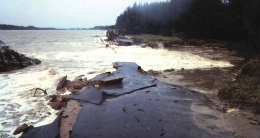
Lake St Lucia, a RAMSAR site within the iSimangaliso World Heritage site, is facing a very
severe water shortage as a result of one of the most severe droughts in living memory. Historical
alteration of the ecosystem upstream of the Park has significantly changed the functioning of the
estuary. This has had an impact on the biodiversity of the system and given rise to a plethora of
management solutions and interventions over the last 60 years.

The current drought has placed Lake St Lucia under increased stress. Public concern has
heightened and the different views of residents, farmers, fishermen, tourism operators, tourists
and visitors, local communities, scientists, nature lovers and conservationists have generated
considerable constructive debate.

This document aims to provide the relevant information to inform, update and provide a BIG
picture overview of how past human intervention in the estuary has contributed to the current
situation and how climatic events and natural forces have shaped it over many years. The history
of the Lake is told as an illustrated story and takes the reader to the present day.

This background sets the scene for iSimangaliso’s GEF (Global Environmental Facility) project
which is currently underway and aims to formulate longer term solutions based on the best
available scientific knowledge. Research collaboration has already paid off as new research on
the mouth dynamics of Lake St Lucia is being used in the management strategy over the next 24
months.

As far as Lake St Lucia is concerned, the iSimangaliso Wetland Park Authority, the statutory body
responsible for the conservation of the Park and protection of its world heritage values, together
with its implementation partner Ezemvelo KZN Wildlife is primarily concerned with improving the
ecological health and sustainable functioning of the entire 70km long estuary and thus, provide
optimal benefits to existing stakeholders and future generations.

Andrew Zaloumis, Chief Executive Officer, iSimangaliso Wetland Park Authority and Bandile
Mkhize, Chief Executive Officer, Ezemvelo KZN Wildlife.

iSimangaliso Wetland Park Authority
Background and Summary
The iSimangaliso Wetland Park was listed as a World Heritage Site1 in 1999, giving recognition to
the area’s ecological processes, biodiversity, conservation history and superlative natural beauty.
Covering an area of 239,566 ha, the Park encompasses unspoiled marine, coastal, wetland,
estuarine, and terrestrial ecosystems. These systems include coral reefs, long sandy beaches,
extensive coastal dunes, estuarine and freshwater lakes, inland dry savannah and woodlands
and wetlands of international importance. These environments provide critical habitats for a
wide range of wetland, ocean and savannah species. This species diversity has arisen because
of iSimangaliso’s transitional and coastal location between tropical and temperate regions.
iSimangaliso’s global significance is not only acknowledged through its World Heritage Site status,
but it also contains Ramsar sites, which are wetlands of international importance

One of these Ramsar2 sites is the Lake St Lucia system, one of the most important estuaries in
South Africa and the largest of only three estuarine coastal lake systems in the country, with a water
surface of 300 km2 and a shoreline of over 400 km. It represents over 80% of the estuarine area of
the southern African sub-tropical region and 60% of the estuarine area of the country, making it the
most important nursery ground for juvenile marine fish and prawns along the east coast.

Lake St Lucia, however, is facing serious hydrological problems. The region is in the grip of
an eight year ‘drought’, with below average rainfall having occurred since 2002. For nearly a
decade, very little water from the system’s five rivers has flowed into St Lucia. While changes
in the catchments of these rivers have affected the amount and quality of water entering the
lake, the major impacts on Lake St Lucia have arisen through human intervention in the Mfolozi
catchment, which is the largest catchment of the Lake St Lucia system. Of particular significance
are the effects of the removal of the swamp vegetation on the floodplain, the canalisation of the
Mfolozi River and the separation of the Mfolozi and St Lucia systems.
1
 The 187 countries that have ratified UNESCO’s World Heritage Convention endorsed the iSimangaliso Wetland Park’s listing as a World Heritage site.
2
  The Convention on Wetlands (Ramsar, Iran, 1971) -- called the “Ramsar Convention” -- is an intergovernmental treaty through which member countries commit to
maintain the ecological character of their Wetlands of International Importance and to plan for the “wise use”, or sustainable use, of all of the wetlands in their territories.
iSimangaliso has four Ramsar sites; namely, the St Lucia Lake System, Turtle Beaches/Coral Reefs of Tongaland, Kosi Bay Lake System and Lake Sibaya.

iSimangaliso Wetland Park Authority
                                                                                        1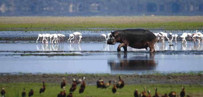
Over the past fifty years, there have been numerous attempts to solve the problems that have
arisen as a result of these changes, ranging from an extensive dredging operation to the diversion
of water from the Mfolozi river through a link canal, all of which have failed to restore the hydrological
and ecological functioning of Lake St Lucia. It is evident that no quick fix solution is possible.

The iSimangaliso Wetland Park Authority has raised funding through the Global Environmental
Facility to investigate and formulate long term solutions that will, as far as possible, restore the
natural hydrological and ecological functioning of this important system. Using the best available
scientific knowledge, current management activities are focused on diverting fresh water from the
Mfolozi into the lake and allowing the Mfolozi and St Lucia mouths to join.

This document provides an overview of Lake St Lucia, with particular reference to the problems
facing the system due to the transformation of the Mfolozi floodplain, the separation of the Mfolozi
and Lake St Lucia estuary mouths and the way in which these problems have been dealt with
in the past. It also provides information on the current management approach, the steps that
are now being taken and how the iSimangaliso Global Environmental Facility (GEF) project will
support the iSimangaliso Authority to find a sustainable medium to long term solution.

iSimangaliso Wetland Park Authority
                                                   2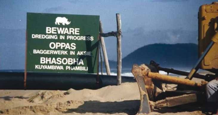
Formation of Lake St Lucia
The last Ice Age ended about 20 000 years ago. During that period glaciers were extensive with
large quantities of water being locked into the ice, resulting in the sea level being about 100 m
lower than it is at present. River valleys, formed by long periods of erosion, extended far out
beyond the present shoreline. When the sea level subsequently rose, it flooded back up these
valleys reaching its present level about five to six thousand years ago. The undersea canyons
found off the iSimangaliso coastline are the courses of these ancient rivers.

Lake St Lucia was originally a deep lake that extended northwards into what is now the Mkhuze
swamps, and the present Mfolozi floodplain (Figure 1). Sea levels rose rapidly to the present
level about 6000 years ago moving the estuary up the river valley, resulting in flooding of the low
lying area behind the dunes forming the large lake system shown in A. Over the past 6000 years
natural infilling of the lake and floodplains with sediment has produced the smaller and shallower
system we see today (B)

A) 6000 years ago						                                                                           B) Present

Figure 1. The size of Lake St Lucia has changed over time due to 6000 year old natural sediment accumulation. (Taylor, April 2011)

There is evidence that the original mouth of the Mkhuze River was to the northeast of the lake in
the vicinity of Leven Point which is about 55 km north of the present St Lucia estuary mouth, but
this link to the sea closed off permanently approximately 2000 years ago as the forested coastal
dunes formed. Unlike Lake Sibaya3 , which lost its link with the sea approximately 10,000 years
ago during the late Pleistocene / early Holocene period, Lake St Lucia maintained its linkage with
the sea via the 22km Narrows and a common mouth with the Mfolozi and Msunduzi.

There are five catchments in the Lake St Lucia system, namely, the Mfolozi, Mzinene, Hluhluwe,
Nyalazi and Mkhuze rivers, of which the Mfolozi is the largest (see figure 2).
3
    Interestingly, in the Thonga language a water or grain basket is referred to as an isibaya.

iSimangaliso Wetland Park Authority
                                                                                    3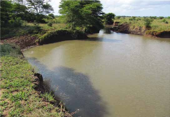
Figure 2: Of the 5 catchments in the Lake St Lucia system, the Mfolozi is the largest, and during closure of a combined Mfolozi
and St Lucia mouth, contributes significantly to the freshwater of the Lake.

The historical functioning of the St Lucia estuary
In the past, and under suitable conditions, the Mfolozi and the St Lucia mouths formed a single
estuary with a deep open water area which was colloquially known as the ‘St Lucia Bay’ or in isiZulu
as iChweba laseNtlengeni (‘Tonga Lagoon’) (figure 3). This description reflects historical records
of ships taking shelter in the ‘bay’ when the mouth was open, and the account of shipwrecked
Portuguese explorers in the 1500s attest to the size of the bay4 .

Until the 1950s the Mfolozi and St Lucia mouths were combined, forming one estuarine system. In
common with South Africa’s other sub-tropical estuaries, the combined estuary may have closed
off from the sea during low flow5 periods that generally occur in the drier winter season, and
during drought conditions. Under natural circumstances breaching would have occurred during
the following rainy season depending on the volume and timing of the river flow. Taking into
account the volume of water and the topography (size, shape and depth) of the Lake, the closure
of the combined mouth was infrequent and usually of short duration (a few months). In conditions
of reduced inflow, the closed period may have extended from months to years and eventually
have become permanent. The closure of the combined mouth would have been followed by
back flooding onto the Mfolozi floodplain, the lake surrounds and upwards towards the northern
reaches of the Mkhuze swamp. Under these conditions, the Mfolozi would have been a significant
source of freshwater for the lake.

4
 St Lucia got its name from Portuguese navigators on their voyages around the southern tip of Africa from the late 1400s. The early navigators are not recorded
as having ventured ashore, but the later accounts of Portuguese shipwreck survivors grounded on the Southern African shore provide the first written record on the
St Lucia area. In 1554, survivors from the shipwreck Sao Bento, attempted to make their way north along the coast to Delgoa Bay (now the bay around Maputo,
Mozambique). They could not find a way to cross the St Lucia estuary, and so travelled inland for several days to travel around what they called the ‘Medaos do
Ouro’ river (‘the River of the Sands of Gold‘), or Lake St Lucia. Twenty travellers died on that journey.

5
    A low flow refers to the smallest volumes of water moving through an estuarine or river system at a given time.

iSimangaliso Wetland Park Authority
                                                                                  4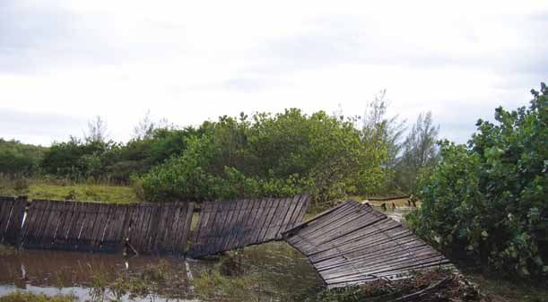
Figure 3. Up until 70 years ago the St Lucia Bay stretched from the current day ski-boat club to Maphelane
(photographer: unknown)

Figure 4. A postcard from 1936 showing the combined St.Lucia Estuary & Mfolozi River mouths

1
    The 187 countries that have ratified UNESCO’s World Heritage Convention endorsed the iSimangaliso Wetland Park’s listing as a World Heritage site.

iSimangaliso Wetland Park Authority
                                                                                5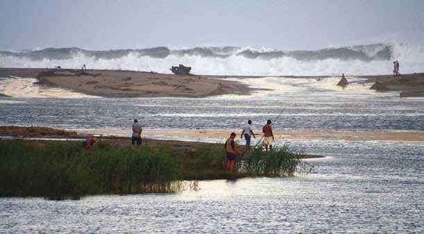
The dynamic Lake St Lucia system: variable states
Under natural conditions the St Lucia Lake system is highly dynamic and will move between fresh
and hyper-saline states in response to rainfall and river flow. The lake can move through three
broadly defined states:

•          A predominantly freshwater system with high inflows and medium water levels with an open
           mouth which allows for exchange between the estuary and sea,

•          A brackish system (salinity levels below that of sea water) with lower water levels and a
           constricted mouth i.e. narrow opening allowing some exchange between the estuary and the
           sea, and

•          A closed mouth with varying water levels dependent on rainfall and river flow with the
           potential for hyper-salinity and desiccation during winter and droughts.

A predominantly fresh water system would favour freshwater aquatic plants such as pond weed
(Potamogeton) and water fowl, such as ducks, whilst a more saline system would support higher
numbers of salt tolerant aquatic plants such as sea grasses and estuarine dependent species
such as spotted grunter and penaeid prawns. However, the system may experience varying
combinations of these conditions.

These changes are extremely important, enabling this estuarine system to support a number of
different combinations of plants and animals contributing significantly to its rich biodiversity. This
phenomenon is an important aspect of iSimangaliso’s world heritage values and is universally
recognised.

Droughts and floods play an important role in defining the state(s) of the Lake St Lucia system.
Major floods, such as Domoina, are capable of shaping and changing the physical nature of the
system i.e. the depth and sediment distribution, while droughts will influence salinity and lake
level. The annual average rainfall is just over 1000 mm but it has been recorded below 500 mm
and above 3000 mm. Figure 5 indicates that since the early 1900s the annual rainfall has been
below average for 60% of the time with 25% of these below average periods lasting for three
years or more.

Figure 5: Annual rainfall index defined as the normalised deviation from the annual average. A positive rainfall index indicates a
relatively wet year whilst a dry year has a negative index (Lawrie and Stretch, 2010)

 1
     The 187 countries that have ratified UNESCO’s World Heritage Convention endorsed the iSimangaliso Wetland Park’s listing as a World Heritage site.

iSimangaliso Wetland Park Authority
                                                                                 6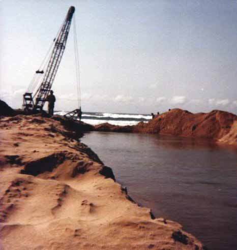
Floods caused by tropical cyclones are an ongoing part of the region’s climate, and can bring over
700 mm of rain in several days. The most recent of these, Cyclone Domoina, occurred in 1984
and set the record for the most rainfall ever recorded in South Africa for a 24 hour period: on the
31 January 1984 - 597 mm was recorded.

It is not unknown for the sea to breach a sand bar and open the estuary mouth. For instance, in
March 2007 Cyclone Gamede formed out at sea, and on a spring high tide generated high seas
that breached St Lucia estuary mouth (see figure 6 & 7).

Fig 6: In 2007 Cyclone Gamede caused high seas that breached the St Lucia mouth, resulting in the inflow of sea water into
the Narrows and the lake. With low water levels and insufficient flow out of the lake the mouth closed after about 5 months
(photograph: iSimangaliso Authority).

Fig 7: Cyclone Gamede’s high seas damaged the board walk on the northern estuary bank– a sharp reminder of the need to
keep hard infrastructure to a minimum in this dynamic environment (photograph: iSimangaliso Authority).

iSimangaliso Wetland Park Authority
                                                             7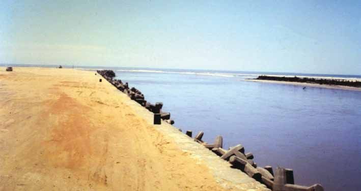
Transformation of the Mfolozi floodplain and the
management of the Lake St Lucia system
While changes in the catchments of these rivers have affected the amount and quality of water
entering the lake, the major impacts on the Lake St Lucia system have arisen through human
intervention in the Mfolozi catchment.

In 1911 the Mfolozi floodplain began to be converted into agricultural land for sugar cane farming
(see figure 8). In the late 1920s, a system of drainage canals was built. By the 1940s concern was
being expressed about sedimentation in the mouth region, which was attributed to the canalisation
of the Mfolozi River. In the early 1950s the combined mouth closed and there was extensive back-
flooding. This was dealt with by artificially breaching the mouth. Back-flooding can be disruptive to
agriculture on the floodplain as low lying fields become inundated with water. Thus, farmers prefer
to drain the fields by artificially breaching the mouth.

Figure 8: The Mfolozi and Msunduzi catchments with the wetlands of the floodplain indicated. More than half of the floodplain
wetlands had been transformed by 1960 (Begg 1988).

iSimangaliso Wetland Park Authority
                                                              8
Figure 9: In 1956 the St Lucia mouth was opened with spades by the farmers (photograph: N Brits)
Figure 10 and 11: Artificial breaching of the Mfolozi mouth in 1979 and 1993 (photographs: N Brits)
From 1956 a separate mouth was opened for St Lucia (see figure 9), and since then the separation
of the Mfolozi and St Lucia estuary mouths has been actively maintained. This separation was
considered necessary to prevent the threat of sediment accumulation in the lake.
1
The 187 countries that have ratified UNESCO’s World Heritage Convention endorsed the iSimangaliso Wetland Park’s listing as a World Heritage site.
iSimangaliso Wetland Park Authority
9At that time, it was assumed that the estuarine function was ‘improved’ by keeping the mouth
open permanently, and this was actively done by means of dredging, concrete retaining walls and
dolosse such as those used in the Durban and Richards Bay harbours (see figure 10, 11 & 12).
Figure 12: Lake St Lucia estuary mouth in 1983 showing the retaining walls and dolosse keeping the mouth open.
(photograph: A.T. Forbes)
Extensive dredging in the Narrows took place in an attempt to increase exchange with the Lake and
keep the mouth open (see figures 13, 14 & 15). The dredging operations and the maintenance of
an open mouth were conducted by the Reclamation Unit, which was established by the Umfolozi
Co-operative Sugar Planters (UCOSP) in 1952. The Government, through the Department of
Water Affairs, took over the management of the Reclamation Unit in the early 1960s (see the
map below which outlined the Department of Water Affairs and Forestry plan for dredging the
mouth and the estuary). Thereafter the unit was housed in the Department of Public Works from
1976, the Roads Department under the Natal Provincial Administration in 1977 and then the Natal
Parks Board in 1988. Ezemvelo KZN Wildlife, the Natal Parks Board’s successor, took over the
management of the Reclamation Unit in the late 1990s.
Dredging operations lasted for over 40 years and included construction of the dredger harbour,
the Link Canal between the Mfolozi and the Narrows, construction of levees along the Narrows
and pumping of large amounts of spoil into wetlands during construction of the Link Canal. A
22 km channel was dredged from the mouth, up the Narrows to the main Lake. A sand trap was
dredged immediately upstream of the mouth to capture marine sediments brought in by flood
tides which were then removed by suction dredger and deposited back onto the beaches north of
the mouth. This was done to prevent marine sediments from closing the mouth.
1
The 187 countries that have ratified UNESCO’s World Heritage Convention endorsed the iSimangaliso Wetland Park’s listing as a World Heritage site.
iSimangaliso Wetland Park Authority
10Figure 13: Map prepared by the Reclamation unit in 1965 showing the dredging operation in the mouth and Narrows, and the
illustration of the retaining walls and dollose.
1
The 187 countries that have ratified UNESCO’s World Heritage Convention endorsed the iSimangaliso Wetland Park’s listing as a World Heritage site.
iSimangaliso Wetland Park Authority
11Figure 14: Dredger Inkwazi operating in the Narrows in 1976 (photograph: N Brits)
Figure 15: From 1988 Ezemvelo KZN Wildlife and its predecessor, the Natal Parks Board, managed the dredging operations in
the Lake St Lucia system, focusing mainly on dredging a sediment trap in the mouth (photograph: N Brits).
1
The 187 countries that have ratified UNESCO’s World Heritage Convention endorsed the iSimangaliso Wetland Park’s listing as a World Heritage site.
iSimangaliso Wetland Park Authority
12The table below gives an historical timeline of the different mouth conditions of the Lake St Lucia
mouth, the alteration of the floodplain and the manipulation of the mouth by breaching. The table
appeared in the report from the Kriel Commission of Enquiry into St Lucia, published in 1966.
Although only a partial record that does not show the season of mouth closure and opening, it is
an important part of the historical picture which builds our understanding of the way in which the
system functions.
Year Condition of mouth Year Condition of mouth
1823 Mouth closed 1922 Mouth closed, re-opened naturally in 1923
1833 Mouth closed 1925 Serious flood in Mfolozi
1849 Mouth open, navigable channel 1927 Drainage and canalization of the
Mfolozi swamp started
1851 Almost closed 1932 Mouth closed and was re-opened artificially
1852 Mouth open 1936 Completion of Warner’s Drain in
Mfolozi swamp
1853 Mouth open 1952 Separate mouth cut for Mfolozi and Mfolozi
and St Lucia estuary separated
1856 Mouth open after floods 1951- Mouth closed
1955
1885 & Mouth usually completely blocked 1955 Flood
1895 from September to November?
1902 Mouth could not be crossed 1956 Serious flood
(probably by boats)
1903 Mouth closed 1955- Mouth closed and was re-opened artificially
1961 on three occasions
1905 Mouth open 1963 Serious flood
1911 Flood in Mfolozi 1965 Mouth closed for a few days and
was dredged open again
1918 Serious flood in Mfolozi
Table 1: Historical record of the St Lucia Lake mouth condition between 1823 and 1965 which was extracted from the
Commission of Enquiry St Lucia, 1966 (van Niekerk L and Huizinga P, 2011)
Impacts on the Lake St Lucia system
Droughts and hyper-saline conditions with an open mouth
During dry periods, including winters and droughts, the open mouth policy allowed seawater to
flow unimpeded into the lake, maintaining the water levels of the lake but with harmful effects on
the lake eco-system as salinities rose for prolonged periods.
In the severe drought of 1967 to 1972, the northern rivers ran dry and evaporation of the lake
water and the influx of seawater brought huge amounts of salt into the estuary system. Due to
the separate mouth policy, the benefits of the Mfolozi water were lost to the estuary system. The
salinity levels of the lake rose to two or three times that of seawater, which is 35 grams of salt
1
The 187 countries that have ratified UNESCO’s World Heritage Convention endorsed the iSimangaliso Wetland Park’s listing as a World Heritage site.
iSimangaliso Wetland Park Authority
13per litre of water. With no fish in the estuary due to high salinities, very few birds could utilise the
system and starving crocodiles had to be airlifted out. Hippos were unable to find fresh water to
drink (figure 16 & 17). The steady flow of water from the sea maintained higher lake water levels
resulting in hyper-saline water which then killed the shoreline vegetation. Without the stabilising
effect of the vegetation, islands and shorelines were eroded.
Figure 16 and 17: Hippo and crocodiles were captured and moved to areas with fresh water and food supply in the drought of
1968-1972. (photographs: P Dutton).
Opening the St Lucia estuary mouth now, and keeping it open with dredgers, under the current
(2002-2011) drought conditions would simply replicate the extreme saline conditions of 1969-
1971 and would have similar bio-diversity implications.
Restoring the health of the entire 70 km long Lake St Lucia system is of utmost importance
and cannot be served by a single strategy of keeping the mouth open permanently, which may
benefit a few fishermen at the expense of many and even the entire estuary system. Management
interventions have to be guided by the international and statutory obligation to conserve
iSimangalio’s World Heritage values and protect this important Ramsar site for all South Africans
and the world.
1
The 187 countries that have ratified UNESCO’s World Heritage Convention endorsed the iSimangaliso Wetland Park’s listing as a World Heritage site.
iSimangaliso Wetland Park Authority
14Mfolozi water and sediments
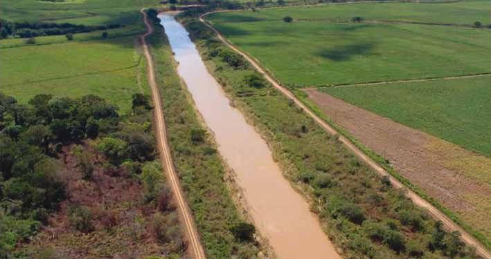
Agricultural development in the Mfolozi floodplain involved canalisation of the river and the
removal of the wetland vegetation that slowed flood waters and filtered out sediment. Canalisation
delays the overflow onto the floodplain from the main river channel, which means that more
sediments are delivered to the mouth without the trapping effects of the floodplain (figure 18).
The separation of the Mfolozi from St Lucia was previously considered important in preventing
sediments accumulating in the estuary.
Figure 18: The canalisation of the Mfolozi river has led to an increase in the speed of the water flow.
(photograph: Ezemvelo KZN Wildlife)
After the 1967-1972 drought several interventions aimed at bringing sediment free freshwater into
Lake St Lucia to prevent hyper-saline conditions were implemented. These included the digging of
a channel through part of the Mkhuze swamp to short-circuit one of the pans and bring freshwater
directly into the Lake. The Mkhuze intervention failed and has resulted in serious environmental
consequences, which persist today (see figure 19 and 20).
1
The 187 countries that have ratified UNESCO’s World Heritage Convention endorsed the iSimangaliso Wetland Park’s listing as a World Heritage site.
iSimangaliso Wetland Park Authority
15Figure 19 and 20: Erosion of the Mpempe channel caused by increased water flow as a result of the straightening of the channel
to bypass the pan and bring water from the Mkhuze catchment into the lake (image and photograph courtesy of P Grundling).
1
The 187 countries that have ratified UNESCO’s World Heritage Convention endorsed the iSimangaliso Wetland Park’s listing as a World Heritage site.
iSimangaliso Wetland Park Authority
16Another failed intervention was the construction of the Link Canal with the Intake Works on the
Mfolozi to manage the amount of freshwater and sediment load flowing from the Mfolozi into the
Narrows. When Cyclone Domoina struck on 31 January 1984 it showed that the St Lucia system
cannot be managed through hard engineering solutions. The flood washed away the dredger and
most of the concrete retaining wall and dolosse at the St Lucia estuary mouth (figure 21).
Figure 21: The cyclone Domoina floods and the associated high seas removed the concrete retaining wall, dolosse and road on
the north bank at the mouth. (photograph: A.T. Forbes)
The Intake Works survived Cyclone Domoina despite being totally submerged, but the stilling basin
was never completed and the Link Canal never commissioned. As a result of cyclone Domoina,
the Natal Parks Board and later its successor, Ezemvelo KZN Widlife, adopted a management
approach that tried to work with natural processes and was less rigid about the open mouth policy.
Owing to concerns about sediments from the Mfolozi being deposited in the St Lucia estuary the
decision to maintain separate mouths for the Mfolozi and St Lucia remained in place.
Loss of estuarine function
The prolonged closures of the St Lucia estuary mouth have had a negative impact on the estuarine
functioning of the estuary system. There has been a noticeable reduction in marine migrant fish
species, such as the Natal stumpnose Rhabdosargus sarba, and the shallow water prawn fishery
on the Thukela Banks has collapsed as St Lucia has ceased to function as a nursery for the
shallow water prawn and other species (figure 22). It is anticipated that these shallow water prawn
fisheries will recover once the estuarine functioning of the Lake St Lucia system is restored.
1
The 187 countries that have ratified UNESCO’s World Heritage Convention endorsed the iSimangaliso Wetland Park’s listing as a World Heritage site.
iSimangaliso Wetland Park Authority
17Figure 22: Commercial penaeid prawn species that use St Lucia estuary as a nursery (photograph: N Forbes)
Artificially maintaining an open mouth of the St Lucia Lake system by dredging, for example, will
not support estuarine functioning and is not a sustainable solution due to the negative biodiversity
impacts. Management solutions that focus on bringing freshwater into Lake St Lucia to prevent
hyper-saline conditions will not result in the improved estuarine functioning of the system. There is
broad agreement among scientists that estuarine functioning is driven by the Mfolozi River when
both mouths are combined.
However, the risk of sediment accumulation in Lake St Lucia must be considered. The University of
KwaZulu-Natal, in collaboration with researchers from the Netherlands, has registered a research
project with iSimangaliso that is using hydraulic modeling to investigate the significance of Mfolozi
sediments within the Lake St Lucia basin and estuary system. This research6 is important in
informing iSimangaliso’s ongoing review of the management options for Lake St Lucia, including
an assessment of the strategy of maintaining separate mouths for the Mfolozi and Lake St Lucia.
6
The adaptive management approach taken in managing the Lake St Lucia system is based on the best available scientific knowledge at any given time. As
scientific understanding improves the management strategy is adapted as iSimangaliso actively seeks out this knowledge. There are 129 research projects being
undertaken by independent institutions in the iSimangaliso Wetland Park, of which 34 researchers have focussed their work on the Lake St Lucia system.
iSimangaliso Wetland Park Authority
18Management strategy for 2011/12
Based on the review of current scientific knowledge, particularly the recent research on the sources
and dispersal of sediments, and an assessment of the status of the Lake St Lucia system the
following management actions will be implemented during 2011/12 by the iSimangaliso Wetland
Park Authority, supported by Ezemvelo KZN Wildlife:
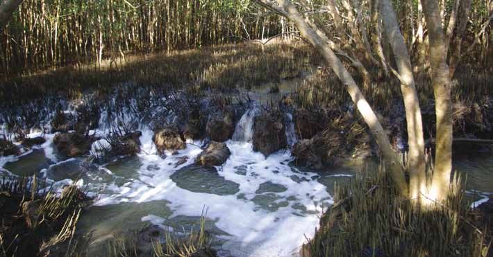
1) Diversion of water via the Back Channel when the Mfolozi mouth is closed (figure 23). This allows
silt-free fresh water to enter Lake St Lucia. Ways to enhance these flows via the Back Channel
are also being investigated. Back flooding of low lying sugarcane fields is a consequence of
not artificially breaching the mouth. The sugar cane farms affected by back flooding are actually
situated in the estuarine functional area7, and when the mouth is open the farms lie within the
tidal reaches of the Msunduze River, which increases the risk of farming activity in these areas.
Whilst some of the farms in this tidal area have implemented flood protection measures, such
as levees, some have not. The strategy to artificially breach the mouth will serve the interests of
the farmers but will undermine the health of the St Lucia system by preventing, inter alia, fresh
water entering the estuary via the Back Channel. iSimangaliso is managing towards restoring
the ecological functioning of the Lake St Lucia system. Under this management regime artificial
breaching of the Mfolozi mouth does not happen as a matter of course.
Figure 23: The Back channel diverts fresh water into the Narrows of Lake St Lucia when the Mfolozi mouth is closed
(photograph: iSimangaliso Authority).
2) Allowing the Mfolozi and Lake St Lucia estuary mouths to join to form a combined mouth, and
thereby allowing it to function as naturally as possible. With a combined mouth it is likely that
the mouth will be open more often than closed.
7
The area lying below the 5m contour line delineates the boundary of the estuary as set out in the methods for fresh water flow requirements for estuaries (DWAF
2008).
iSimangaliso Wetland Park Authority
193) An ongoing process of review and evaluation is in place and monitoring of salinity, lake levels
and the health of the system continue as these interventions are being implemented. If problems
develop the mouth can be breached (either the combined mouth, or a separate Mfolozi outlet).
This is in line with an adaptive management approach.
Restoring the ecological functioning of the
Lake St Lucia system
iSimangaliso is developing a longer term solution to improve the hydrological functioning of
Lake St Lucia through the iSimangaliso GEF Project which is investigating and will support the
implementation of a solution that will restore the hydrological and ecological functioning of this
important estuary system. This project aims to address biodiversity conservation, hydrological
issues and ecosystem functioning of the iSimangaliso Wetland Park. The objective of this
component is to support key studies that improve knowledge of the Lake St Lucia system, and
to select the best feasible option to restore estuarine function; and to implement the necessary
interventions to achieve this.
The first phase of this component is complete. This involved analysis of the alternatives and
selection of the most ecologically feasible solutions, also taking into consideration social, financial,
political and economic considerations. These options have been presented for comment and
input to scientists and other stakeholders.
The next phase involves detailed analysis of the selected options and an environmental
authorisation process with stakeholder participation. The tender process for this has been
initiated. Finally, a portion of the budget has also been set aside to begin the implementation of
the preferred option.
Consultation
During phase 1 of the GEF project a scientific review workshop was held and attended by 41
scientists including hydrologists, estuarine ecologists, estuarine hydrodynamic specialists,
social scientists and geologists. Several stakeholder and public meetings have also been held
in 2011. In addition, a workshop organised in 2010 by the Consortium for Estuarine Research
and Management (CERM) and funded by the Water Research Commission reviewed studies
on the Mfolozi estuary and floodplain with a view to providing information that would support
management. A Background Information Document (BID) has also been widely circulated. As
the project unfolds there will be an ongoing consultation process aimed at providing information
and receiving input and ideas from a range of different stakeholders. For further information and
updates on the GEF project contact GEF@iSimangaliso.com.
1
The 187 countries that have ratified UNESCO’s World Heritage Convention endorsed the iSimangaliso Wetland Park’s listing as a World Heritage site.
iSimangaliso Wetland Park Authority
20Bibliography
Bate GC, Whitfield AK and Forbes AT (Editors) (2011). A review of studies on the Mfolozi Estuary
and Associated Flood Plain, with emphasis on information required by management for future
reconnection of the River to the St Lucia system. WRC Report No. KV 255/10.
Begg, GW (1988). The wetlands of Natal. Part II. The distribution, extent and status of wetlands
in the Mfolozi catchment. Natal Town and Regional Planning Commission Report No. 71.
Pietermaritzburg.
Botha GA and Singh R (2011). Draft Sediment supply study. Development, empowerment and
conservation in iSimangaliso Wetland park and surrounding region; Mkhuze, Mzinene, Hluhluwe
and Nyalazi Rivers component report to the iSimangaliso Wetland Park Authority under the GEF
project.
Copley G J (2009). Shifts In Environmental Policy Making Discourses: The Management Of The
St Lucia Estuary Mouth. Unpublished Masters Dissertation. University of KwaZulu-Natal.
Department of Water Affairs and Forestry (DWAF) (2008). Water Resource Protection and
Assessment Policy Implementation Process. Resource Directed Measures for protection of
water resources: Methodology for the Determination of the Ecological Water Requirements for
Estuaries. Version 2. Pretoria
Lawrie R, Chrystal C and Stretch D (2011). On the role of the Mfolozi in the functioning of St Lucia:
Water Balance and Hydrodynamics. WRC Report No. KV 255/10. Pp 99-109.
Lawrie R and Stretch D (2008). Evaluation of the short-term link between the Mfolozi Estuary and
St Lucia Lake. Unpublished report commissioned by the iSimangaliso Wetland Park Authority.
Lawrie R.A., Stretch D 2010 Anthropogenic impacts on the water and salt budgets of St Lucia
estuarine lake in South Africa Estuarine, Coastal and Shelf Science, Volume 93, Issue 1, Pages
58-67.
Taylor R (2011). The St Lucia-Mfolozi Connection: A Historical Perspective. WRC Report No. KV
255/10. pp 2-42.
Taylor R (April 2011) St Lucia – the big picture; April 2011 assessment. Unpublished Ezemvelo
KZN Wildlife report.
For further reading on the subject download the document ‘iSimangaliso Umfolozi_St Lucia
Investigations Literature reviewed’ from www.iSimangaliso.com.
1
The 187 countries that have ratified UNESCO’s World Heritage Convention endorsed the iSimangaliso Wetland Park’s listing as a World Heritage site.
iSimangaliso Wetland Park Authority
21You can also read