Case Study Dynamic Integration of Property Registration, Land Records and Cadastral Maps in Haryana
←
→
Page content transcription
If your browser does not render page correctly, please read the page content below

Case Study
Dynamic Integration of Property
Registration, Land Records and Cadastral
Maps in Haryana

Department of Revenue and Disaster Management Haryana

Date – March, 2014

Name of Authors/Content creators

PricewaterhouseCoopers
Dynamic Integration of Property Registration, Land Records and Cadastral Maps in Haryana
1. EXECUTIVE SUMMARY
The integrated land records, right of records, mutations and cadastral maps is one of the
ambitious projects for state revenue department to bring about transparency and efficiency
in land records domain. The project was rolled out by Department of Revenue and Disaster
Management Haryana to ensure efficiency, effectiveness and transparency. The project
management for such state-wide transformational project is a herculean task. This kind of
integration is also a significant and very important step for migrating from existing
presumptive land titling system to conclusive titling system, as envisioned under National
Land Records Management Programme (NLRMP).
In the Land Domain, citizens are more concerned about land; it being a primary source of
income and asset. The impact of the land transformation is a necessity to bring in
transparent, valuable and effective measures for farmers, citizens, institutions, government
departments, corporate bodies and industries. Making tamperproof records and removing
all kinds of malfunctioning in the land domain is the primary objective of NLRMP project.
The system has helped in significant reduction of fraudulent practices and corruption at the
hands of private deed writers, local advocates, Patwaries and other middlemen.
The Department of Revenue and Disaster Management, Government of Haryana deals with
maintaining and updating of revenue records, transaction by way of sale, mortgage,
collection of revenue, consolidation of holdings, etc. The functionaries of Revenue
department come into close contact with general public in connection with various
activities/ transactions dealing with immoveable property. To improve accessibility, stop
manipulation and enhance efficiency of the land record system, Government of India has
launched NLRMP (National Land Record Modernization Programme) with a primary
objective of end-to-end computerization of land records.
2. INTRODUCTION
The deed registration work was automated in Haryana in the year 2003, using the Haryana
Registration Information System (HARIS) software developed by NIC team and land records
management was being done using the Haryana Land Records Information System
(HALRIS).
The major objectives to be fulfilled by the Integrated HALRIS project were:
Facilitating integration between registration software and Land records Software to
avoid manual mutation triggers and prompt updating of land records for every action in
registration software
Allowing system based integration with Land Acquiring bodies for better planning and
dispute resolution.
Disclaimer: This case study has been prepared solely as a basis for class discussion. This case is not intended to
serve as an endorsement, a source of primary data, or an illustration of effective or ineffective management.
The publication may not be digitized, photocopied, or otherwise reproduced, posted or transmitted, without the
permission of DARPG.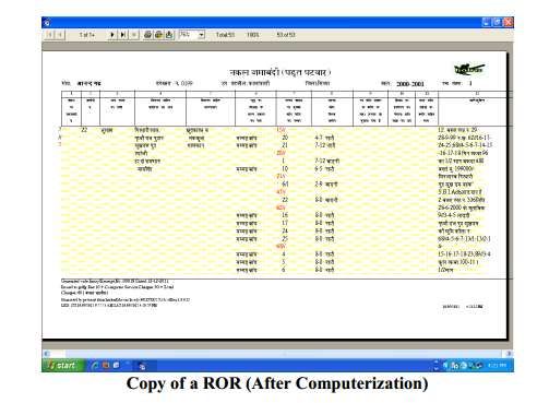
Dynamic Integration of Property Registration, Land Records and Cadastral Maps in Haryana
Making banks (Loan Lenders) as a part of Land Management System to bring in better
control and oversight for land parcels under purview
Remove malpractices arising due to non-exchange of data between deeds registration,
Land Documents and Bank transactions.
Maintain single version of truth for all documents and ensuring limited process hassles
to the end beneficiary i,e. Citizen.
In practice, there exists a Single line of hierarchy in the department for revenue and property
registration related work. The Director Land Records (DLR) is also the Inspector General of
registration (IGR) of the State. A single revenue officer designated as ‘Tehsildar’ heads the
Tehsil office, who functions as circle revenue officer (CRO) while dealing with revenue
matters and function as ex-officio Sub Registrar (SR) for registration of deeds. With a view
to streamline the working of revenue establishment the process of computerization of
Land Records (CoLR) was started under 100% centrally sponsored scheme on one hand
and Property Registration Computerization was started at all Tehsils / sub-Tehsils
(Taluka) of Haryana, in technical consultation with NIC-HRSC by raising the funds through
District Red Cross Societies.
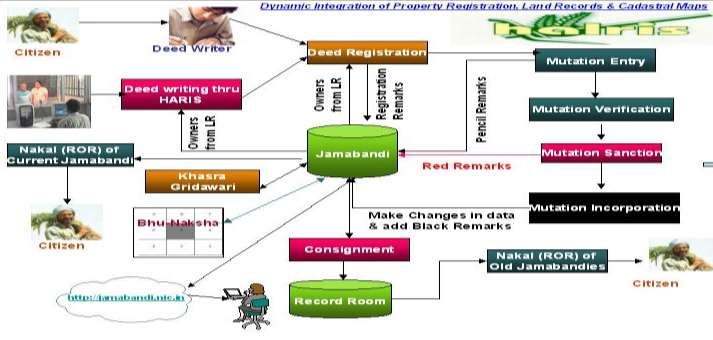
For integrating the digitized maps with the Record of Right and Mutation, Bhu-Naksha
software is being used. All the three i.e. HARIS, HALRIS and Bhu-Naksha work in tight
integration to provide the platform to dynamically integrate the property registration, land
records and cadastral maps.
In most of the States of Indian Union, the Finance department handles property
Registration work and the Revenue Department looks after Land Records Administration
work. Haryana is one of the very few states, where property Registration and the Land
Records Administration work have been merged with a single department. The department
also operates a large number of Acts and Rules, which have a direct bearing with the public.
3. OVERVIEW OF THE PROJECT OWNER
Details of the protagonist/owner:
Shri Krishna Mohan, who has led the state as Additional Chief Secretary & Financial
Commissioner to Government of Haryana is a 1977 batch senior IAS officer of Haryana
cadre, and has been at the helm of various visionary projects in the state. Mr. Krishna
Mohan has served as an administrative head for various Haryana Government Departments
before he retired from service on 31 December, 2013. He is having more than thirty six years
of experience in all aspects and crucial sectors of administration as an IAS officer with core
competencies in a complete range of sectors/departments such as Rural and Urban
Development, Housing, Tourism, Revenue & Disaster Management, Home, State Excise &
Sales Tax, Health, Social welfare, Education, Public distribution, Agriculture, Forest,
Disclaimer: This case study has been prepared solely as a basis for class discussion. This case is not intended to
serve as an endorsement, a source of primary data, or an illustration of effective or ineffective management.
The publication may not be digitized, photocopied, or otherwise reproduced, posted or transmitted, without the
permission of DARPG.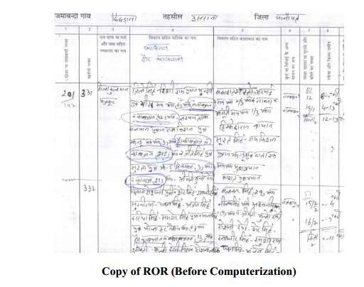
Dynamic Integration of Property Registration, Land Records and Cadastral Maps in Haryana

    Cooperation, Information & Public Relations and Grievance Redressal through several key
    appointments in the state of Haryana and Union Territory of Chandigarh in the capacity of
    the Head of the Department or Administrative Secretary (1977-2013)

    He retired as Additional Chief Secretary & Financial Commissioner, Department of Revenue
    and Disaster Management, Government of Haryana. Throughout his tenure, Shri Mohan has
    worked on various transformational and citizen centric projects.

    His experience on the project:

    Shri Krishna Mohan led the projects which involved the transformation in citizen services
    and increase in the efficiency of Government functions. e-Governance was one of the key
    tools Mr. Mohan emphasized to bring in this change. He provided the support for
    Administrative Reengineering of processes involved in the management of revenue records.
    During his tenure as ACS & FCR he provided a new direction to the project with his quick
    decision making and leadership qualities.

    Under him, the Department floated an Appointment Management System (AMS) for Deed
    Registration to enhance the transparency. HARSAC, which is a nodal agency for GIS work in
    the state, has been entrusted to accomplish the job of digitization of cadastral maps and
    scanning of old records under this programme.

    4. PROJECT OVERVIEW / HISTORY OF THE PROJECT

    In the year 2000, Revenue department, Haryana in technical consultation with NIC-
    Haryana, decided to computerize the registration of documents at all sub registrar offices
    (SRO) of Haryana in a phased manner. The National Informatics Center (NIC) team studied
    the entire deed registration work at SRO and a solution named as Haryana Registration
    Information System (HARIS) was developed.

    Initially HARIS system was implemented in six SROs on self-sustainable basis by using the
    District Red Cross society as the venture capitalist. By the year 2002-03, HARIS was rolled
    out in the entire state. HARIS improved the delivery of services at SROs and also increased
    the stamp duty collection by standardizing the method of collector rate fixation and stopping
    the registration of undervalued deeds.

    On the other side, computerization of land records (CLR) was also going on as a 100%
    sponsored scheme of Department of Land Resources (DoLR), Government of India. Though
    significant progress was made and almost 92% Jamabandi data was digitized using the
    FoxBase/Unix platform, this data was not fully used for citizen services due to various
    reasons like lack of interest and heavy workload on Patwaries. This resulted into delay in
    data verification and finalization. Jamabandies were taken for data entry without
    standardizing the way of writing. It was found that each Patwari uses multiple ways of

Disclaimer: This case study has been prepared solely as a basis for class discussion. This case is not intended to
serve as an endorsement, a source of primary data, or an illustration of effective or ineffective management.

The publication may not be digitized, photocopied, or otherwise reproduced, posted or transmitted, without the
permission of DARPG.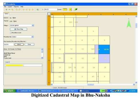
Dynamic Integration of Property Registration, Land Records and Cadastral Maps in Haryana

    writing the shares of owners/cultivators in the same Jamabandi. Contractual staff was used
    for data creation. Also, there has been no nodal officer to assign exclusive responsibility of
    the project at the district level.

    With the success of HARIS system Revenue department Haryana decided to redesign and
    integrate the Land Records computerization solution with the HARIS System. In 2003 a new
    land records computerization solution named as Haryana Land Records Information System
    (HALRIS) was designed and implemented in all the tehsil/sub-tehsils in a phased manner.
    Data created by the erstwhile CLR scheme was converted and ported to the HALRIS system
    and jamabandies were made online by applying the pending mutations. Process of data
    updation was a very big challenge for the department. The various types of Jamabandis and
    incorporating the mutations have been studied and standardized across the state. Once the
    workflow based property Registration System and Land Records Administration system
    were standardized and stabilized, a need was felt to integrate the Property Registration
    System and Land Records system in a workflow environment. Accordingly, the NIC-HRSC
    developed an integrated HALRIS software product, which dynamically integrates the
    property registration and Land Records workflow under a single unified database.

    Finally in year 2007, citizens’ services were initiated from the HALRIS system. The
    integrated HALRIS software product provides a complete solution for the management of
    Land Records in the State and improved delivery of Government to Citizen (G2C) services
    related to Land Administration. Web interface for Jamabandi Nakal has also been
    developed and hosted at http://jamabandi.nic.in.

    As far as coverage is concerned, geographically HARIS and HALRIS have been implemented
    in all the 122 Tehsils and Sub-Tehsils of Haryana. Bhu-Naksha has been implemented for
    150 villages of Ambala tehsil.

    Out of 7081 villages, RoR data of around 6918 villages has been entered, validated and made
    on-line. Remaining villages being under consolidation are to be taken up progressively for
    computerization, in line with completion of consolidation work. RoRs of more than 6000
    villages of most of Tehsils/sub-Tehsils have been made available on web site
    http://jambandi.nic.in

    5. SITUATION IN PROJECT OWNER’s STATE/ DISTRICT

    In the manual system a lot of mutations were pending due to which there was delay of 1-2
    years in the preparation of the new jambandi. Also, people used to visit the Patwari for
    getting the Nakal which he wrote by hand and then certified. So if a Patwari wasn’t available
    for 1-2 days, people could not get the service from any other source and had to wait for the

Disclaimer: This case study has been prepared solely as a basis for class discussion. This case is not intended to
serve as an endorsement, a source of primary data, or an illustration of effective or ineffective management.

The publication may not be digitized, photocopied, or otherwise reproduced, posted or transmitted, without the
permission of DARPG.
Dynamic Integration of Property Registration, Land Records and Cadastral Maps in Haryana
Patwari. Lack of integration led to fraudulent land practices leading to citizen harassment
and delays in administrative processes.
In the manual land management process, delays on account of availability of officers, time
lapse in document search, communication delays, non-availability of online records,
multiple human touch points, etc were major challenges in the efficient delivery of services.
Integration was required between sale deed registration offices, land records management
system of Revenue Department and availability of cadastral maps under a single shelter to
deliver hassle free and efficient citizen services. This was required to bring in process
standardization and simplification of the records management.
Stakeholders / beneficiaries involved:
Beneficiaries of the project span from citizen and farmers till the highest administrative
levels. These include -
• Farmers, land owners, buyers/sellers of property
• Business community and other general public
• Revenue and Judicial Courts, Officials of revenue department
• Revenue Department and other Government departments for planning activities
• Financial Institutions and Banks
The project spans involvement from all district Revenue stakeholders including Division
Commissioner Level, collectorate, Tehsildars, Patwari Level, Panchayats, Private deeds
writers, etc.
Financial Commissioner Revenue constitutes the state level standardization & Monitoring
Committee. NIC-HRSC constitutes a dedicated team of professionals for the project. The
workshops were organized at Division Commissioner level, where all stakeholders were
called and various re-engineered processes were discussed.
Steps / action taken at the state / district level to address the problem
Following were the major steps taken to bring in the resolve the integration hurdles and
establish integrated software system:
Involvement of Stakeholders: State level standardization & monitoring committee was
constituted. A dedicated team of professionals for the project was identified by NIC. Each
type of cases of writing the Jamabandi and incorporating the mutations were studied and
standardized across the state.
Process Standardization and Simplification: (a) All applicable deed types were
studied and standardized to form 22 types of deed registration Templates. (b) All type of
Disclaimer: This case study has been prepared solely as a basis for class discussion. This case is not intended to
serve as an endorsement, a source of primary data, or an illustration of effective or ineffective management.
The publication may not be digitized, photocopied, or otherwise reproduced, posted or transmitted, without the
permission of DARPG.Dynamic Integration of Property Registration, Land Records and Cadastral Maps in Haryana
reported cases related to writing of Jamabandi (ROR) and mutations were studied and
standardized and simplified so as to manage them through HALRIS, uniformly across the
state. The cases, which could not be simplified, were incorporated in HALRIS through
suitable customization and enhancement of HALRIS. (c) HARIS & HALRIS were
dynamically integrated in a workflow environment to facilitate online availability of Record-
Of-Right (ROR) on anytime, anywhere basis with security & transparency.
Delegation of Authority: The Collectors have been authorized to declare any Tehsil on-
line. Since the project is being implemented through District Red Cross Societies / District
IT Societies, the Collectors have been empowered at local level to appoint operators, out-
source data entry & verification and procure requisite hardware.
6. MODALITIES OF THE NEW SYSTEM (SOLUTION)
Details of the solution(s) that is implemented:
Following are the major components have been included/ incorporated in the HALRIS
project:
• Dynamic integration of HARIS and HALRIS
• Appointment Management System in HARIS
• Digitization of Cadastral Maps/ Mussavis and integration with Bhu-Naksha
software for handling maps
• Integration of textual HALRIS RoR data with spatial data through Bhu-Naksha
• System based auto-calculation of Stamp Duty based on property location
The strategy adopted to undertake this initiative was simple. The project included
multiple features of implementation over its initial version.
Special focus on Cadastral maps:
The digitization of Cadastral maps of Sirsa and Ambala district were taken-up through
HARSAC (Haryana Space Application Centre), Hissar. The HARSAC (Haryana Space
Application Centre) digitized all the available cadastral maps of Sirsa and Ambala. It
emerged that unless the textual data of Records-of-Rights and spatial cadastral maps are
integrated, the real benefits from ICT interventions will be limited to the citizens. Village
maps of the districts were collected from the Patwaries and cleaned/ corrected maps
were used to make these scan ready. Scanning of village maps was done at minimum 200
dpi gray scale mode in *.tiff format.
The system imports the digitized and verified cadastral vector data in industry standard
spatial data format to the spatial database. The system has the provision of importing
geo-referenced spatial data.
Disclaimer: This case study has been prepared solely as a basis for class discussion. This case is not intended to
serve as an endorsement, a source of primary data, or an illustration of effective or ineffective management.
The publication may not be digitized, photocopied, or otherwise reproduced, posted or transmitted, without the
permission of DARPG.Dynamic Integration of Property Registration, Land Records and Cadastral Maps in Haryana
Innovativeness of the project
Haryana is the first state in establishing dynamic linkage between Land Records
(HALRIS), Mutations & Property Registration (HARIS). The project has been an
exemplary example of continuous innovation to improve service delivery further.
Original project takes care of textual data only; there was no linkage with the maps.
Modified version supports the integration of textual data with the spatial data. Thus as a
result of any transaction or mutation both textual and spatial data sets are updated.
Original project did not support the Token Management to manage the queue at tehsil
level. Token issuance service is added to the HARIS for queue management at
Tehsil/Sub-Tehsil level. Token is issued to parties for deed registration. HARIS
processes the tokens in first in first out order.
In the original project, no mechanism existed to transfer the data of registered deeds to
the state data center. Now, web services based solution is developed to transfer the data
of registered deeds to state data center at day end. Centralized database is used by the
Revenue department to generate various reports related to collection of duty.
No touch screen interface existed in the original project. So for any small information
people were required to stand in queue to get the information. In the existing project
touch screen interface is provided to give access of services to the public. Touch screen
based kiosks are also installed at tehsil level so that general public can access the services
on their own.
Concept of two-dimensional bar code is now being used in the project to make the copies
of ROR tamper proof whereas no such security mechanism was there in the original
project. Two-dimensional bar code is printed on the Jamabandi Nakals so that nakals
can be verified later on.
Application is made to check the stay/attachment on the basis of khasra numbers
whereas original project was not having any such feature. And this application is capable
of synchronizing the central database located at state data center within 15 minutes of
occurrence of any transaction at tehsil and sub-tehsil level.
Provision is made to check the requirement of No Objection Certificate (NOC) from the
Town and Country Planning department on the basis of khasra numbers.
Technology Platform used:
Dot Net platform at front end and SQL Server at backend
Disclaimer: This case study has been prepared solely as a basis for class discussion. This case is not intended to
serve as an endorsement, a source of primary data, or an illustration of effective or ineffective management.
The publication may not be digitized, photocopied, or otherwise reproduced, posted or transmitted, without the
permission of DARPG.Dynamic Integration of Property Registration, Land Records and Cadastral Maps in Haryana
Client Server architecture at HARIS/ HALRIS centres. Automatic data porting to
State Data Centre through web services.
Connectivity between tehsil centres and SDC through SWAN
Bhu-Naksha is on Java and PostgreSQL database
Integrated heterogeneous environment
2-D bar coded and digitally signed RoRs
Appointment Management System and Jamabandi Portal are web based
Security concerns:
For security purposes, it has been ensured that the citizen and government data for land
remains confidential and tamperproof. The system based workflows defined are run with
no human interventions with aid of digital signature and also hosting is taken care of by
State Data Centre. There are two types of access that are provided. User ID and password
based access & Role based access.
Some of the other security features include Biometric authentication, digitally signed
RoRs, two dimensional bar code is used to make the copies of ROR tamper proof,
digitally signed database interface for critical transactions (in Pilot at 2 districts).
Porting of data from HARIS/HALRIS centres to Haryana SDC through secured SWAN
connectivity. Standard Data Centre privacy and security policies have been implemented
at Haryana SDC.
Any issue(s) with the technology used:
The multi-tier technology architecture has been adopted for HALRIS project
implementation. No major/ important issues have emerged from the new service
delivery practices; however the Department is planning to implement some additional
services / facilities shortly for further improving the system.
Service Levels for services:
The project being a citizen centric service delivery initiative, special focus has
been kept on maintaining service levels. Under Right to Service Act Govt. of
Haryana has fixed the max time limits for delivery of citizen service.
For Deed Registration – Same day
For Nakal of ROR – Same day
Sanctioning of Mutation – within 15 days
Measure to ensure adaptability and scalability:
Disclaimer: This case study has been prepared solely as a basis for class discussion. This case is not intended to
serve as an endorsement, a source of primary data, or an illustration of effective or ineffective management.
The publication may not be digitized, photocopied, or otherwise reproduced, posted or transmitted, without the
permission of DARPG.Dynamic Integration of Property Registration, Land Records and Cadastral Maps in Haryana
The solution designed for Land records management is easily adaptable and scalable
since it has immense advantages for all the stakeholders including service beneficiary
and service providers. The adaptability of the solution has been ensured through an ease
of user design of the solution which includes a simple user interface and reporting
module supports the Hindi language.
For Administration, the time saved is being utilized on other office works since there was
an ease of availability of RoR over internet.
Measures to ensure replicability
This solution can be very easily used by other states to provide the similar service to the
public without making major changes to their existing land records software.
The HARIS has already been replicated to states of Orissa, Himachal Pradesh, and Delhi.
Some of the states like Karnataka, Kerala, Punjab, Maharashtra, and Delhi visited
Haryana to see the dynamically integrated system of Haryana.
The solution designed is easily replicable across the state and across the country as -
State wide Area Network (SWAN) is being used to transfer the data to State Data
Center.
Web services are hosted in the State data Center.
Process to issue the digital signatures to all the key functionaries like Tehsildar,
Registry Clerk and Patwaries is on.
Land Records data is being digitally signed to provide the digitally signed copies of
Record of Rights. HARIS and HALRIS will be migrated to web based environment.
Risk Analysis
A project of such a magnitude and scale was envisaged along with certain risks. The
biggest one was Infrastructure management and up-gradation which was required for
the project at various districts and state levels. Stakeholder participation was also
important to ensure that roles and responsibilities post re-engineering of processes and
technological up-gradations are clearly defined. It was imperative that technological
changes be adopted from time to time to ensure service effectiveness and the project
feeds on continuous capacity building and innovations to maintain high quality of service
delivery.
Capacity Building model used:
Disclaimer: This case study has been prepared solely as a basis for class discussion. This case is not intended to
serve as an endorsement, a source of primary data, or an illustration of effective or ineffective management.
The publication may not be digitized, photocopied, or otherwise reproduced, posted or transmitted, without the
permission of DARPG.Dynamic Integration of Property Registration, Land Records and Cadastral Maps in Haryana
For the communication and dissemination strategy, the workshops were organized at
Division Commissioner level, where all the stakeholders were called and various re-
engineered processes were discovered and discussed. A full paper on this e-Governance
initiative has been included for the newly recruited Patwaries in the State. Two capacity
building centers one at Panchkula and other at Patwar Training School Hissar have been
established.
The DIOs of NIC-HRSC were trained on the technical and operational aspects of the
project. The Patwaries were trained at Revenue Training Institute and Patwar Training
School. The DIOs further trained the Job Work contractual operators/supervisors on
day-to-day operations of the system. The training is an on-going process.
7. IMPACT ON THE STAKEHOLDERS/BENEFICIARIES
Efficiency Enhancement
The system has improved the quality of service in Tehsils by reducing the total time
taken by the Tehsil staff for registration. Now documents are returned same day to the
public, earlier it even took weeks/months to get a registered deed. The photographs of
witnesses are also taken along with the sellers and buyers on-line. This has reduced the
incidents of wrong witnesses, which was very prevalent before the implementation of
this system.
On-line availability of Updated Nakal of ROR (Record of Right) to the public helps in
reduction of litigations and frauds, as now it is not possible to sell a same piece of land to
multiple parties/peoples. After this initiative there is significant increase in the stamp
duty collection in-spite of the reduction in the stamp duty rates by the state government.
This increase has been possible because the system has forced the collectors to make
their collector rates uniform and structured. Earlier there was big difference in the
collector rate and the open market rates of the property. Further, now it is not possible to
register a property below the collector rate. Revenue leakage caused by the registration
of undervalued deeds has been stopped. System has also reduced the mutation pendency
to great extent as in online environment one cannot sell the land without doing the
mutation. So this has stopped the practice of doing the deed registration on the basis of
registered deeds. Provision to get the appointment for deed registration has also been
introduced to save the time of the general public and to manage the rush at sub-registrar
offices.
Accessibility & User Convenience
Disclaimer: This case study has been prepared solely as a basis for class discussion. This case is not intended to
serve as an endorsement, a source of primary data, or an illustration of effective or ineffective management.
The publication may not be digitized, photocopied, or otherwise reproduced, posted or transmitted, without the
permission of DARPG.Dynamic Integration of Property Registration, Land Records and Cadastral Maps in Haryana
Citizen is at the centre of this Automation exercise of HALRIS project. Deed templates
are available on the Revenue department’s web site, which can be used by the general
public to write the deed. Collector rates, Stamp duty and Registration fee rates are also
available on web site for the convenience of the public. The system has improved the
quality of service in Tehsils by reducing the total time taken by the Tehsils staff for
registration. Now documents are returned same day to the public earlier sometimes it
took weeks/months to get a registered deed.
This initiative has solved the problem of mutation pendency to a great extent; earlier due
to mutation pendency delay was there in the preparation of the new jamabandi. With
this initiative all mutations are entered at tehsil level and in case of registered deeds it is
generated by the system itself. Mutation process is completed within 15 days in case of
uncontested mutations. Entire user interface is in Hindi language.
Cost benefit analysis:
HALRIS system has reduced the direct and indirect cost incurred by the citizens to get
the services. In the integrated system deed registration process takes only 20-25 minutes
where as in manual system people have to wait for full day for deed registration. 22
standard deed templates are available on website as well as HARIS/HALRIS centers and
e-DISHA centers. This saves thousands of rupees for citizens to be paid to licensed deed
writers.
Significant cost saving due to elimination of need of middle man for appointment and
other services is achieved. This has been made possible due to introduction of
Appointment Management System (AMS). The system has enforced low manual
intervention & data capturing at source. This has led to fewer errors in the records. Web
enabling of the Land Records has helped in bringing transparency in making available
access to the ROR on anytime, anywhere basis.
Benefits to Administration:
Post HALRIS there have been drastic improvements at the departmental level. The
increase has even been recorded during the period when the state government has
reduced the stamp duty. In this system, it is possible to fix a separate rate for different
parts of the same locality by dividing it into the number of segments. So this has reduced
the practice of concealing the exact location of property for saving the stamp duty.
Further, now it is not possible to register a property below the collector rate. This has
stopped the revenue leakage caused by the registration of under-valued deeds.
8. FUTURE ROADMAP / SUSTAINABILITY
Disclaimer: This case study has been prepared solely as a basis for class discussion. This case is not intended to
serve as an endorsement, a source of primary data, or an illustration of effective or ineffective management.
The publication may not be digitized, photocopied, or otherwise reproduced, posted or transmitted, without the
permission of DARPG.Dynamic Integration of Property Registration, Land Records and Cadastral Maps in Haryana
The current system will be further improved. It will be moved from decentralized to
centralized architecture. The introduction of QR code in future for mobile based
scanning verification of documents would help the citizens in verifying the authenticity
of documents using their mobiles. Mobile applications for senior officers of the
Department will help to check status of registration at each tehsil. This system has
already been developed and is under trial run through SMS and Mobile based
notifications for mutations.
The system has been implemented on self-sustainable service charge model by
outsourcing through District Red Cross (DRC) society and District IT Society. The
project has been a successful example of PPP model for e-Governance. Government is
not spending any money to run HARIS and HALRIS centers. In every district DRC/IT
societies are taking the service charge from the users there by making the project self
sustainable. The system has been generating around Rs. 6 Crores as service charges,
which are sufficient for the long term sustainability of the project. Till date more than Rs.
1800 lacs have been collected as service charges, which is enough for executing the other
e-Governance projects related with the Revenue Department. The District Red Cross
Societies and IT Societies are using a part of this fund for the welfare of rural masses in
their district. Now 40% of service charges go to Red Cross, 50% goes to IT Society and
10% goes to FCR office at State Headquarters. The technical expertise of NIC-Haryana is
available at state headquarter and all other districts to assure sustainability of the system
on a long term basis.
The system has also helped in generation of around 500 jobs for the local Haryana boys
and girls, as all the operators have been appointed from the local areas. District Red
Cross Societies are using a part of the service charges for running social welfare
programs for the weaker sections of the society.
Disclaimer: This case study has been prepared solely as a basis for class discussion. This case is not intended to
serve as an endorsement, a source of primary data, or an illustration of effective or ineffective management.
The publication may not be digitized, photocopied, or otherwise reproduced, posted or transmitted, without the
permission of DARPG.Dynamic Integration of Property Registration, Land Records and Cadastral Maps in Haryana
9. ANNEXURE(S):
EXHIBIT – 1 A – Abbreviations
Sr. Abbreviation Explanation
1. RoR Record of Rights
2. DRC District Redcross Society
3. NIC National Informatics Centre
4. DITS District IT Societies
5. FCR Financial Commissioner Revenue
6. SDC State Data Centre
7. SLA Service Level Agreement
8. NOC No Objection Certificate
9. PPP Public Private Partnership
10. AMS Appointment Management System
11. QR Code Quick Response Code
12. SWAN State Wide Area Network
13. HRSC Haryana Right to Service Commission
14. SQL Structured Query Language
15. CLR Computerization of Land Records
16. Patwari A Village Accountant or Registrar
17. Naib-Tehsildar The Deputy or Assistant of Tehsildar
18. Nakal A copy of
EXHIBIT – 1 B – Definitions
Jamabandi (Record of Rights)
It is a document prepared as part of record-of-right in every revenue estate. It contains entries
regarding Ownership, cultivation and up-to-date of various rights in land. It is revised every five
years when a Jamabandi is prepared by Patwari and attested by Revenue Officer. Two copies of
revised Jamabandi are prepared. One copy is consigned to the District Record Room and other
copy remains with Patwari. All changes of rights in land coming to the notice of the Revenue
Agency are reflected in the Jamabandi according to a set procedure after these have been
verified by Revenue Officer.
Disclaimer: This case study has been prepared solely as a basis for class discussion. This case is not intended to
serve as an endorsement, a source of primary data, or an illustration of effective or ineffective management.
The publication may not be digitized, photocopied, or otherwise reproduced, posted or transmitted, without the
permission of DARPG.Dynamic Integration of Property Registration, Land Records and Cadastral Maps in Haryana Mutation Register Mutation indicates the changes that have to be brought about in ownership and title of the land. It contains the information about the khewat of last Jamabandi, which are proposed to be corrected (Column No 1 to 7) and information contained in Column no 8 to 12 is proposed to be established. These columns are self explanatory. Coulm no 13 indicates the types of mutation and its details. Mutation fee is entered in column no 14 and brief report is given in column no 15. Referencing of mutations are made in current Jamabandi in Remarks Column. Khasra Girdawari It is a register of harvest inspections. The patwari conducts field to field harvest inspections every six months in the month of October and March. He records facts regarding crop grown, soil classification, cultivation and capacity of the cultivators. Shajra Nasab Prepared in every estate at the time of settlement and forming a part of record-of-right. Sharja Nasab is pedigree table showing succession to ownership rights occurring from time to time in the estate. It is revised and brought up-to-date every five years and in the interval changes occurring from time to time are reflected in patwari’s copy through suitable references. Latha (Field Book) Popularly named as Shajra, Patwari keeps a copy of the Shajra on Cloth called ‘Latha’. It gives survey numbers and dimension of a field, now-a-days usually prepared on the scale 40 Karam to one Inch. It is prepared at the time of settlement or consildation. Original copy is retained in Tehsil record room and is updated every five years. Patwari’s copy is kept up-to-date through field inspection and incorporation of all transfers attested from time to time. Roznamcha Waqiati It is a diary of daily incidents maintained by the patwari under executive instructions issued from time to time. Patwari makes an entry for each day mentioning briefly the facts relating to rainfall, hailstorms and other natural calamities, transactions in land or other rights, visits by Superior Officers and orders given by them, orders of Civil and Criminal Courts received by him and executed by him, condition of the crop and cattle, various surveys and inspections conducted by him and any other facts of importance coming to his notice or reported to him. Disclaimer: This case study has been prepared solely as a basis for class discussion. This case is not intended to serve as an endorsement, a source of primary data, or an illustration of effective or ineffective management. The publication may not be digitized, photocopied, or otherwise reproduced, posted or transmitted, without the permission of DARPG.
Dynamic Integration of Property Registration, Land Records and Cadastral Maps in Haryana

         EXHIBIT – 2 – Process Flowchart

         EXHIBIT -3 – Comparative Analysis of earlier Vs new system with respect to :

         a. Copy of ROR before HALRIS

Disclaimer: This case study has been prepared solely as a basis for class discussion. This case is not intended to
serve as an endorsement, a source of primary data, or an illustration of effective or ineffective management.

The publication may not be digitized, photocopied, or otherwise reproduced, posted or transmitted, without the
permission of DARPG.
Dynamic Integration of Property Registration, Land Records and Cadastral Maps in Haryana
b. Copy of ROR before HALRIS
c. Copy of cadastral map in Bhu-Naksha
Disclaimer: This case study has been prepared solely as a basis for class discussion. This case is not intended to
serve as an endorsement, a source of primary data, or an illustration of effective or ineffective management.
The publication may not be digitized, photocopied, or otherwise reproduced, posted or transmitted, without the
permission of DARPG.Dynamic Integration of Property Registration, Land Records and Cadastral Maps in Haryana
EXHIBIT – 4 – Calculation and the details of the allocated budget under the new system
To meet the operational expenditure project is being implemented on self sustainable
service charge based model. Now 40% of service charges go to Red Cross, 50% goes to IT
Society and 10% goes to FCR office at State Headquarters. NLRMP funds are being used
to create the ICT infrastructure, Digitization of cadastral maps and scanning of old
records.
Disclaimer: This case study has been prepared solely as a basis for class discussion. This case is not intended to
serve as an endorsement, a source of primary data, or an illustration of effective or ineffective management.
The publication may not be digitized, photocopied, or otherwise reproduced, posted or transmitted, without the
permission of DARPG.You can also read