The Citadel of Turin: geometric design and underground archaeological evidence - RiuNet
←
→
Page content transcription
If your browser does not render page correctly, please read the page content below
Defensive Architecture of the Mediterranean / Vol XII / Navarro Palazón, García-Pulido (eds.)
                                                                                         © 2020: UGR ǀ UPV ǀ PAG

                                                        DOI: https://dx.doi.org/10.4995/FORTMED2020.2020.11466

The Citadel of Turin: geometric design and underground
archaeological evidence

Roberta Spallone a, Fabrizio Zannoni b
a
    Politecnico di Torino, Turin, Italy, roberta.spallone@polito.it
b
    Associazione Museo Pietro Micca, Turin, Italy, fabriziozannoni@yahoo.it

Abstract
The Citadel of Turin (1564) is one of the first pentagonal modern fortification. For over two centuries it
was the fulcrum of Turin defences, finally unarmed and largely dismantled during the second half of the
nineteenth century. However, the lower sections of main defences and detached works were spared and
buried inside the filled ditches, as well as the underground countermine system. Significant historical
drawings, documenting the building of external defences are selected aiming to recognize geometric cri-
teria that rules the subsequent phases, and to relate the designed fortification with the archaeological ev-
idence.
Keywords: Geometry, graphical analysis, archaeological investigation, conflict archaeology.

1. Introduction
The Citadel of Turin, designed by Francesco                    lected. They are the object of graphical analysis
Paciotto and built from 1564, is one of the first              through digital re-drawing, aimed to hypothesize
and most famous examples of pentagonal mod-                    the geometric criteria that rules the subsequent
ern fortification. The new fortress, whose design              construction phases, and to relate the designed
is featured by the rigorous concatenation of de-               fortification with the archaeological evidence,
fensive elements that expresses the close link be-             today the subject of systematic recovery, study
tween architecture, geometry and ballistics, be-               and enhancement from the 1950s.
came operative since 1566, with the placement
of the first artillery. For over two centuries it              2. Architecture, geometry and ballistics in the
was the fulcrum of Turin defences, finally un-                 historical drawings of the Citadel
armed and largely dismantled during the second
                                                               When possible, the selected original drawings
half of the nineteenth century. However, the
                                                               were analysed and directly reconstructed in the
lower sections of main defences and detached
                                                               archives where they are kept. It means that they
works were spared and buried inside the filled
                                                               were surveyed, measured, and redrawn by digital
ditches, as well as the underground countermine
                                                               tools, with the aim of recognizing geometric
system. Significant drawings, which document
                                                               constructions, alignments, parallelisms, and,
the succession of interventions to build the belt
                                                               mainly, geometric relationships between fortifi-
of external defences between the siege of 1640
                                                               cations elements, sequences of tracing, and
and the early 18th century, and one of the first
                                                               shooting lines. Each plate’s frame and the graph-
half of the 19th century, just before the partial
                                                               ic scale in “trabucchi” (unit of measurements
demolition of the above-ground parts, were se-
                                                               used in Piedmont until first mid of the nineteenth

                                                        1409
century, equivalent to about 3,0825 m) when it is            These features inspired further analyses about
present, have been measured. Then, the fortifica-            the historical drawings of the Citadel of Turin
tions drawings were redrawn by CAD in true                   (Spallone, 2018), and some consideration were
scale, using the millimetre as reference unit,               proposed in relation to:
both for measuring the original maps and re-
                                                             •   the irregularity of the internal and external
drawing the Citadel and the external defences.
                                                                 pentagon;
Finally, CAD drawings have been superimposed
                                                             •   the shape of the bastions;
to the original maps for verifying the quality of
the reconstruction.                                          •   the presence of the second flank;
                                                             •   the geometric relationship between flank and
                                                                 curtain.
2.1. Working methods and main references
for the geometric re-construction                            Today research widens to the external defences:
The survey phase involved the search for the                 ravelins, counterguards, demi-lunes, as they
tracing methods of the past taking into account:             were realized, or only designed, over the centu-
which instruments (compasses, rulers, set                    ries, and their relationships with the Citadel. The
square), which tracing tools (metal points, lapis,           selected drawings can be classified as in scale
pens), which rendering techniques (colours,                  survey drawings, but some of them also repre-
shading) were in use at that time. The reading of            sent artefacts in project or under construction.
the chapter devoted to the “Instrumenti                      A significant precedent for the present analysis
dell’Architettura” in the Architettura civile by             is the survey drawing by Carlo Morello pub-
Guarino Guarini could be illuminating in this                lished in a large format book (400 x 460 mm)
sense (Guarini, posthumous 1737). Moreover,                  (Morello, 1656), which analysis revealed a sub-
the constructions of the regular pentagon given              stantial consistency with the measurements stat-
by Ptolemy (IV-III b.C.), Dürer (XV-XVI a.C.),               ed by Fara (Fara, 2001). The main features of
Herbert (1689) as well as that by Guarini who                the Citadel drawn by Morello are: the applica-
divided the round angle in five equal parts of 72°           tion of Dürer’s method for constructing the inte-
(1676) have been considered. Guarini’s regular               rior pentagon (thought to be regular) on the plot,
fortress, described as a pentagonal citadel in the           as demonstrated by the location of the well
Trattato di fortificatione (Guarini, 1676), cer-             (Fara, 2001); the different measurements of the
tainly is an important reference for understand-             curtains; the length of the curtain about 3/5 of
ing the ideational logic of the so called Modern             the side of the interior pentagon; the presence of
Fortresses.                                                  the second flank more or less pronounced on the
Previous studies (Spallone, 2017) highlighted                five curtains, varying in length from about one-
the peculiarities of Guarini’s scheme: the geo-              fifth of the curtain almost to zero, along the
metric concatenation, the regularity of the plan,            shorter curtains.
and the proportion between the parts. In particu-
lar, emerged:                                                2.2. Results of the graphical analyses

•   the construction of the pentagon through the             Some years later, Michel Angelo Morello, son of
    division of the angle at the center into five            Carlo Morello, drew the Citadel as a part of an
    equal parts;                                             incomplete collection of Military Drawings
                                                             which were identified by Viglino and Bonardi.
•   the division of the side of the interior penta-
                                                             Morello’s drawing about the Citadel was pre-
    gon into five equal parts, with the middle
                                                             sumed to be either a copy of or preparatory
    three delimiting the curtain and the lateral
                                                             drawings (Viglino Davico, Bonardi Tomesani,
    ones indicating the position of the bastion
                                                             2001) for the Theatrum Sabaudiae, and dated
    flank perpendicular to the curtain;
                                                             1663-1664 by Peyrot (Peyrot, 2000). The graph-
•   the presence of the second flank between the
                                                             ical reconstruction of Michel Angelo Morello’s
    razant and fichant lines of defence.
                                                             drawing leads to the hypothesis that it was born

                                                      1410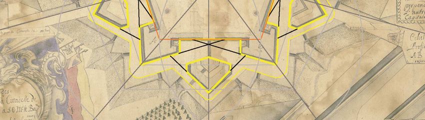
from a regular pentagon based on the side of the An anonymous drawing of the Citadel, referable
Mastio. The adjacent sides coincide with the to the Nineties of the seventeenth century, de-
sides of this regular pentagon, although they are serves a particular attention. It was accurately
shorter, and the sides towards the countryside drawn, but seems to be unfinished, being the ex-
are parallel with those of the regular pentagon. ternal ramparts and a building inside the Citadel
Each side of the interior pentagon is divided into drawn by lapis. It presents a new structure, the
five parts, as Guarini proposed a few years later, “Pastiss” on the capital line of San Lazzaro bas-
with 1/5 delimiting the position of the bastions tion. The Pastiss (that means jumble for its com-
and leaving 3/5 for the development of the cur- plex shape) is a casemate, today preserved, built
tain. Even all the razant lines of defence con- between 1572 and 1574 and featured by a very
verge in the angles between the flanks of the original trefoil plan. The sharpness of the draw-
bastions and the curtains, eliminating the second ing could be appreciated in several details, e.g.
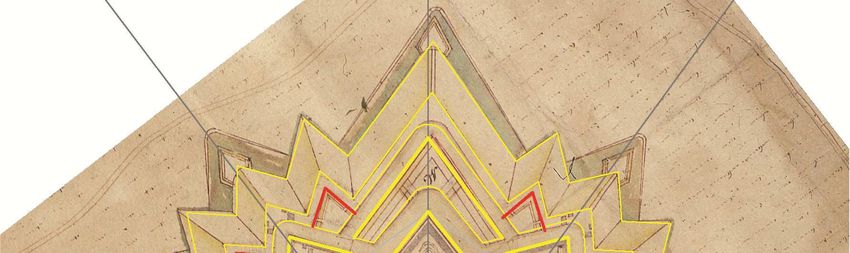
flanks. Michel Angelo’s drawing shows similari- the alignments of the razant defensive lines of
ty with the survey by his father Carlo about the the ravelins to the slots for cannons in the adja-
ratios between the side lengths of the exterior cent bastions. The interior and exterior pentagon
and interior pentagons and that of the curtains, are subject to the same squeezing effect of the
resulting in a similar “squeezing effect”, but also Citadel by Michel Angelo Morello, but also to a
a greater search for regularity and the lack of the rotation of the shorter sides towards the inside.
second flanks, that reveals a different idea of de- Instead, the ravelins maintained the alignment
fensive strategy. Also the ravelins seem to be and the parallelism with a regular pentagon. It
regularized and the razant lines passing for their follows that the capital lines aren’t in axis with
faces impact the angles between the bastions’ the ravelins, except that of the bastion opposite
faces and the flanks. The well is quite close to to the curtain of the Mastio. Guarini’s ratio be-
the intersection of the circumferences of Dürer’s tween the interior pentagon and the curtain is
construction. observed and the second flanks are present in all
the curtains.
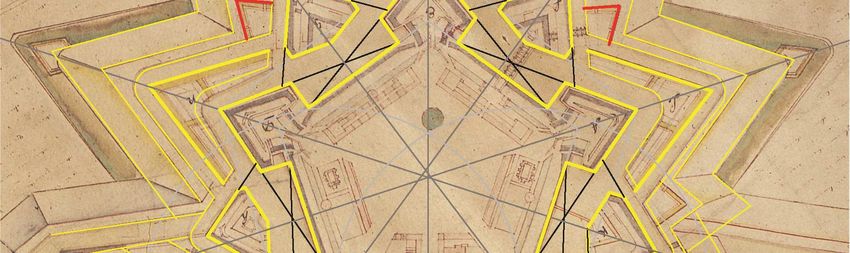
Fig. 1. Michel Angelo Morello, Cittadella di Torino
(740 x 470 mm). Graphical analysis and geometric
Fig. 2. Anonymous, Cittadella di Torino (732 x 507
construction superimposed on the original plate. (Isti-
tuto di Storia e Cultura dell’Arma del Genio di Roma, mm). Graphical analysis and geometric construction
Biblioteca 40/b-n.18798. Reconstructive drawing: R. superimposed on the original plate. (Archivio di Stato,
Spallone). Carte topografiche per A e B, Torino 1, Mazzo 1. Re-
constructive drawing: R. Spallone).
Moreover, there are two demi-lunes, never real-
In the same years a detail of the project for the
ized, that flank the ravelin in front of the Mastio.
completion of the city fortifications shows the
counterguards realized in front of the three bas-
1411
tions facing the countryside and the demi-lunes                        bastions are not regular. In relation to the previ-
flanking the ravelins, designed, but not built.                        ous drawings analysed, the ravelins have the ver-
The particular of the Citadel is in a small scale in                   tex angle wider than that of the bastions. So, a
relation to the other plates, so it is more evident-                   larger portion of the bastions’ faces are protected
ly regularized, although the proportions of the                        by the ravelins. All the curtains have the second
interior and exterior pentagons are the same of                        flank, more or less pronounced. The location of
the previous drawings. The faces of the bastions                       the well seems even more random than in the
are perfectly aligned with the vertex between the                      previous map.
opposite flank and curtain, thereby there isn’t the
second flank. The faces of the ravelins seem to
be aligned with the vertices of the interior penta-
gon. The south-west ravelin in contact with the
walls is aligned with the capital line of the oppo-
site bastion and rotated, probably due to the
connection with the wall. The position of the
well seems a bit random: it does not respect the
construction of Dürer and is asymmetric.

                                                                       Fig. 4. Auguste de la Vallée, Plan des Sousterrains de
                                                                       la Cittadelle de Turin, 100 trabucchi=147,5 mm (660 x
                                                                       495 mm). Graphical analysis and geometric construc-
                                                                       tion superimposed on the original plate. (Archivio Sto-
                                                                       rico del Comune, SIM D554. Reconstructive drawing:
                                                                       R. Spallone).

                                                                       The latest drawings among the selection are two
                                                                       maps by Agostino Chiodo, representing the plan
                                                                       of the Citadel and the countermine tunnels, re-
                                                                       spectively. The first one is dated 1846, and both
Fig. 3. Anonymous, Projet General pour l’Achevement                    are reduced in scale 1:2000. The plan of the
des fortifications de la Ville et Citadelle de Turin, detail,
                                                                       above-ground structures demonstrates a particu-
100 trabucchi=102 mm (1300 x 857 mm). Graphical
                                                                       lar interest in the buildings present inside the
analysis and geometric construction superimposed on
                                                                       Citadel, that are described about their functions
the original plate. (Archivio di Stato, Carte Topografiche
e disegni, Ufficio generale delle finanze, Tipi Sezione II             and date of construction. It could imagine that
Ufficio generale delle finanze, Torino fortificazioni,                 the aim of this drawing, realized immediately
mazzo 356. Reconstructive drawing: R. Spallone).                       before the dismantling of the above-ground arte-
                                                                       facts, was the documentation of the existing
The plan of the Citadel, drawn by Auguste de la                        buildings at that date. From the geometric point
Vallée between the Twenties and the Thirties of                        of view, while the drawing of the Citadel seems
the eighteenth century shows the underground                           very similar to Michel Angelo Morello one, that
works. Also in this case the sides of the interior                     of the ravelins seems to be inspired to other reg-
pentagon are aligned or parallel with those of a                       ulator criteria. Indeed, the axes of the ravelins
regular pentagon, while the exterior pentagon                          are coincident with the lines passing from the
has the side on the right of that where the Mastio                     opposite bastion’s vertex and the mid of the cur-
is located considerably closer than the others to                      tain, so they are perfectly symmetric with re-
the interior pentagon. It follows that the adjacent

                                                                1412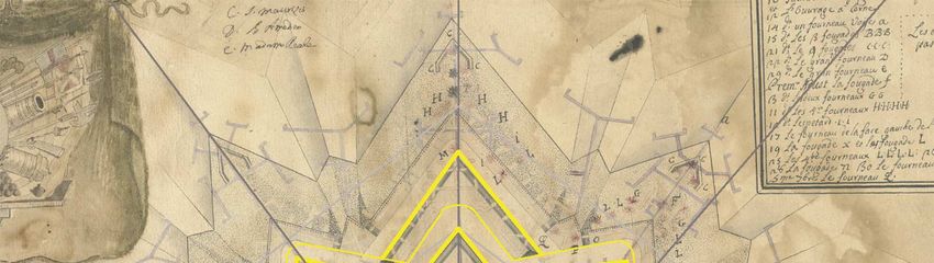
spect to the curtains and their vertex angle is                       greatly expanded knowledge about the location
more pronounced than that of the bastions.                            and consistency of archaeological deposits, of
                                                                      which significant portions have been investigat-
                                                                      ed, documented and, where possible, preserved
                                                                      and open to visitors.

                                                                      3.1. The demolition of the citadel and the
                                                                      formation of archaeological deposits
                                                                      Downgraded from stronghold to simple barracks
                                                                      area on 9 May 1855, the citadel was disarmed
                                                                      and progressively dismantled with the Regio
                                                                      Decreto of 22 May 1856, saving only the main
                                                                      gate, the Maschio. As foreseen in the new city
                                                                      expansion plan, Progetto di ingrandimento della
                                                                      Città di Torino verso l’ex-Cittadella, approved
                                                                      on 5 April 1857, the demilitarized area was des-
Fig. 5. Agostino Chiodo, Piano della Cittadella di To-
                                                                      tined to be urbanized (Comoli, Fasoli, 2000). As
rino colla distribuzione interna dei varj Edifizi, in Rac-            confirmed in several excavations, the results of
colta dei disegni delle fortificazioni esistenti negli Stati          demolitions, which were concluded in the last
di terraferma del Re di Sardegna ordinata da S.M. il Re               years of the nineteenth century, were very une-
Carlo Alberto… Graphical analysis and geometric                       ven and strictly dependent on the intended use of
construction superimposed on the original plate. (Bib-                the plots of land of the new city district. In gen-
lioteca Reale, Disegni, O.XIII. Reconstructive draw-                  eral, the upper section of bastions, curtains and
ing: R. Spallone).                                                    detached works was removed up to 0,75-1,00 m
                                                                      below the level designed for the new roads,
3. Underground Archaeological Evidence                                which in turn corresponded to floor level of the
                                                                      covered way above the counterscarp. Therefore,
Archaeological research plays an essential role
                                                                      below the non-built areas, such as streets,
in studies concerning the disappeared citadel of
                                                                      squares or the courtyards of the buildings them-
Turin and represent, by now, a real direct source
                                                                      selves, the lower sections of the fortification
of primary importance for the reconstruction of
                                                                      works still remain, in some cases up to 3-4 m
its fortified plant
                                                                      high, and, although filled, the cellars of maga-
Despite the partial demolition of the fortifica-                      zines, barracks and other logistic buildings. The
tions, whose remains have been further reduced                        radical destruction of the fortified works is in-
by over a century of urban development, the                           stead documented, for the most part, where the
evaluation of the potential for archeological re-                     excavations of the new buildings led to the deep
mains was a successful operation since the first,                     tampering of the subsoil, interfering in many
although occasional, studies dating back to the                       cases also with the countermines galleries placed
years between the end of nineteenth and the be-                       at the highest level of the underground defensive
ginning of twentieth century. The most important                      system, at meters 5-6 of depth. The underground
results were achieved with extensive systematic                       installations placed at greater depth, however,
research, aimed at recovering the fortified works                     did not suffer structural damage although, in
still existing in the subsoil, promoted and con-                      many cases, were “rationally” used as disposal
ducted by Museo Civico Pietro Micca, starting                         areas for the materials extracted during excava-
from the end of the 1950s. For over thirty years,                     tions.
moreover, the increasing amount of data deriv-
                                                                      Until the early twentieth century the remains of
ing from urban excavations, directed by So-
                                                                      the fortifications demolished and buried, some-
printendenza Archeologia, Belle Arti e Paesag-
                                                                      times found during municipal works carried out
gio per la Città Metropolitana di Torino, has

                                                               1413
on the former citadel's grounds, which produced               were excavated, where the counterminers could
further destruction, were not object of attention.            plant their charges of gunpowder. Wrongly con-
The archaeological excavation carried out by                  sidered of sixteenth-century origin, this auxiliary
Riccardo Brayda in 1890, in order to recover the              work, designed by the piedmontese engineer An-
sixteenth century Pozzo Grande (Great Well),                  tonio Bertola, has recently been dated, based on
designed by Francesco Paciotto in the inner                   data obtained from unpublished archival sources,
square of the citadel and famous for the double               to the years 1705-1709, excluding some short
helical ramp, was an isolated attempt, almost                 sections dating back at the end of the seven-
immediately interrupted for economic reasons                  teenth century (Bevilacqua, Zannoni, 2006).
(Zannoni, 2000).
                                                              The recovery of a large part of the countermine
                                                              system involved in the underground battle in
3.2. The recovery of buried fortifications
                                                              1706, contributed to providing new perspectives
In the early twentieth century, the bicentennial              for the study, currently in progress, of the under-
celebrations of the siege of 1706 were the start-             ground battlefield, associating the data obtaina-
ing point for the first systematic studies and res-           ble from the archaeological evidence document-
toration works. Research and excavations, re-                 ed, in emergency conditions, by Guido Amoretti
started in the second half of the century, were               in the 1950s, and those that emerged from the
specifically directed, wherever possible, on the              most recent investigations and surveys, conduct-
most significant elements of the Citadel, summa-              ed by members of the Museo Pietro Micca, on
rized below.                                                  sites of fighting between opposing miners.
In 1909 the discovery of a section of the de-
tached work called “Mezzaluna del Soccorso”
and a part of its countermine system was the ba-
sis for three topographical studies published, be-
tween 1910 and 1913, by Colonel Pietro Magni.
These works, based on the integration between
evidence and archival sources, contributed, for
the first time, to the preservation of the galleries          Fig. 6. Left: Agostino Chiodo, Piano Generale delle
found, that were open to visits since 1913 and,               Contromine della Cittadella di Torino, in Raccolta dei
then, used as shelters during the Second World                disegni delle fortificazioni esistenti negli Stati di terra-
War. These studies also formed the basis for the              ferma del Re di Sardegna ordinata da S.M. il Re Carlo
                                                              Alberto… (Biblioteca Reale, Disegni, O.XIII). Right:
subsequent research of Colonel Guido Amoretti,
                                                              General view of the lower capital gallery in the coun-
begun in the second half of the 1950s. After the              termine system of the ravelin “del Soccorso” (P.
foundation of the Pietro Micca Museum, in                     Bevilacqua).
1961, the projects of exploration, study and re-
covery were extended, by Guido Amoretti, to the               Another important topographical reference was
entire countermine system (Bevilacqua, Zanno-                 given by the excavations, carried out by the As-
ni, 2007). The system consisted of five pairs of              sociazione Amici del Museo Pietro Micca, of the
main capitals galleries, connected with masonry               sixteenth-century external defense known as
stairs, placed at m-6 and m-13 below the glacis               “Pastiss”. Built between 1572 and 1574, by or-
of the bastions and ravelins facing the country-              der of Duke Emanuele Filiberto di Savoia, with
side. Four smaller systems, formed by a single                a project by Ferrante Vitelli, the casemate was
capital gallery, guaranteed the defense of the                located inside the main ditch of the Citadel, in
glacis and covered way in the sectors included                front of the bastion San Lazzaro. The main front
between bastions and ravelin. A magistral gal-                was characterized by a profile en trefle, with a
lery, which ran under the covered way, consti-                countermine gallery inside the foundations, be-
tuted the underground communication among                     low the bottom of the ditch. The section emerg-
galleries of the different ramparts. Finally, from            ing from the ground was internally formed of
the main galleries, a series of mine branches                 two floors, covered with barrel vault, both with a

                                                       1414
regular series of embrasures for the defense of                   structure and dug up to its maximum estimated
the edge and the bottom of the external ditch.                    depth. Two short horizontal tunnels were dug to
The gorge towards the bastion defended the                        a depth of m -5 and m -13 to gain access to the
main ditch by means of small cannons, placed                      interior. The deepest tunnel brought to light the
behind embrasures open through the wall. A                        lower end of one of the two ramps, and the ac-
large gallery guaranteed communication with the                   cess arch to the basin for watering. The upper
citadel. In 1705 the Pastiss was incorporated into                part of the ramps, however, was completely de-
the new counterguard San Lazzaro, losing any                      molished before the complete burying of the
defensive function (Amoretti, Menietti, 2000).                    well, at the end of the brief siege of 1799. The
Largely spared from nineteenth-century demoli-                    exploration well used during the excavations al-
tions, the Pastiss has been the subject of a re-                  lows today the visit to the recovered structures.
search and safeguard project, begun since 1976,
culminating, in 2014, in the restoration of the en-
tire recovered western section.

                                                                  Fig. 8. Left: Michel Angelo Morello, Facciata interiore
                                                                  con Profili del Pozzo havanti nominato (Istituto di Sto-
                                                                  ria e Cultura dell’Arma del Genio di Roma, Biblioteca
                                                                  40/b-n.18798). Right: The lower terminal of a helical
                                                                  ramp at the end of the 2006 excavation phase (P.
Fig. 7. Left: Louis Guibert, [Pianta del Pastiss], 1702.
                                                                  Bevilacqua).
(Archivio di Stato, Materie Militari, Intendenza Gene-
rale Fabbriche & Fortificazioni, Mazzo III Inv., f. 4v).
Right: View of the western section of Pastiss at the end          4. Conclusion
of the 2014 restoration (S. Bigando).
                                                                  The documentation and recovery operations
The excavation of the Pozzo Grande, located ex-                   briefly summarized, represent the result of a cen-
actly below the school building Ricardi di Netro,                 tury of fieldworks, particularly significant if
                                                                  considered in relation to the era in which they
is the last, in chronological order, of main objec-
                                                                  started, where the concept of preserving the re-
tives pursued by Museo Pietro Micca. The struc-                   mains of this nature and chronology was not es-
ture was largely completed between 1565 and                       tablished at all. The topographical landmarks
1567. The hypogean section was characterized                      represented by the recovered evidence, consti-
by two superimposed and independent helicoidal                    tute today a fundamental element of reference
ramps, running inside two concentric masonry                      for the protection activity carried out by So-
cylinders, to lead the quadrupeds of the garrison                 printendenza, culminated in 2017 in the creation
to the watering at groundwater and, then, return                  of a new archaeological area, containing the re-
to the surface. At the summit the well was                        mains of the ravelin “degli Invalidi” and the re-
crowned by an elegant two-storey building, a                      lated logistic structures, the first surface fortified
                                                                  works brought to light definitively since the time
columned loggia above an arcaded portico,
                                                                  of their partial demolition. The validity of the re-
completed in 1607. Authorized by the So-                          sults obtained from the interpolation of material
printendenza, the excavation was carried out in                   evidence with archival data is undoubtedly a
two phases, in 1995 and 2006. An exploration                      strong stimulus both to develop research in the
well was positioned next to the sixteenth-century                 field of conflict archaeology, as the study of the

                                                           1415
underground battlefield of 1706 is already prov-                Notes
ing, both to continue to investigate, in terms of
reconstructive design, the themes related to the                While the research is the result of the collabora-
relationships between geometry, architecture and                tion between the authors, paragraphs 1 and 4
firearms.                                                       were written by R. Spallone and F. Zannoni,
                                                                paragraph 2, 2.2, 2.2 by R. Spallone, paragraph
                                                                3, 3.1, 3.2 by F. Zannoni.

Bibliography
Amoretti, G.; Menietti, P. (2000). “Riscoperta e valorizzazione del forte torinese detto «Pastiss»”, in Amoretti, G.;
   Petitti, P., eds., La scala di Pietro Micca 1958-1998: Atti del Congresso Internazionale di Archeologia, Storia e
   Architettura Militare, 11-13 novembre 1998, Torino, Camedda & C. snc., Torino, pp. 31-55.
Bevilacqua, P.; Zannoni, F. (2006). Mastri da muro e piccapietre al servizio del Duca. Cronaca della costruzione
    delle gallerie che salvarono Torino, Giancarlo Zedde, Torino.
Bevilacqua, P.; Zannoni, F. (2007). “Le «gallerie di Emanuele Filiberto». Breve storia di un luogo comune”, in Mola
    di Nomaglio, G.; Sandri Giachino, R.; Melano, G.; Menietti, P., eds., Torino 1706. Memorie e attualità
    dell’assedio di Torino del 1706 tra spirito europeo e identità regionale: Atti del convegno, 29-30 settembre
    2006, Centro Studi Piemontesi, Torino, pp. 291-336.
Comoli, V.; Fasoli, V. (2000). 1848-1857. La Cittadella di Torino, Archivio Storico, Torino
Fara, A. (2001). “Geometrie della fortificazione e architettura da Borromini a Guarini”, Mitteilungen des Kunsthisto-
    rischen Institutes in Florenz, 45(1-2), pp. 103-189.
Guarini, G. (1676). Trattato di fortificatione, che hora si usa in Fiandra, Francia, et Italia; composto in ossequio del
   sereniss. principe Lodovico Giulio cavagliere di Savoia, Appresso gl’heredi di Carlo Gianelli, Torino.
Guarini, G. (1737). Architettura Civile, Gianfrancesco Mairesse, Torino.
Morello, C. (1656). Avvertimenti sopra le fortezze di S.R.A. del Capitano Carlo Morello primo ingegniere et logote-
   nente generale di Sua arteglieria, Biblioteca Reale di Torino, Ms. Militari 178; Facsimile ed., Biblioteca Reale
   di Torino, Consiglio Regionale del Piemonte, Torino, (2001).
Peyrot, A. (2000). “Le immagini e gli artisti”, in Roccia, R. ed., Theatrum Sabaudiae. Teatro degli Stati del Duca di
    Savoia, Archivio Storico della Città di Torino, Torino, pp. 31-65.
Spallone, R. (2017). “The «Regular Fortress» by Guarini and the Citadel of Turin”, Nexus Network Journal, 19 (2),
    pp. 255-277.
Spallone, R. (2018). “The Citadel of Turin «in Absentia». Drawings and Reconstruction Hypotheses after Demoli-
    tion”, in Marotta, A.; Spallone, R., eds., FORTMED 2018. Defensive Architecture of the Mediterranean: Inter-
    national Conference on Modern Age fortifications of the Mediterranean coast, 18-20 October 2018, Torino,
    Politecnico di Torino, Torino, pp. 249-256.
Viglino Davico, M.; Bonardi Tomesani, C. (2001). Città munite, fortezze, castelli nel tardo Seicento. La raccolta di
    disegni ‘militari’ di Michel Angelo Morello, Istituto Italiano dei Castelli, Roma.
Zannoni, F. (2000). “Le fonti documentarie del Cisternone della cittadella in relazione con il dato archeologico”, in
   Amoretti, G.; Petitti, P., eds., La scala di Pietro Micca 1958 - 1998: Atti del Congresso Internazionale di Ar-
   cheologia, Storia e Architettura Militare, 11-13 novembre 1998, Torino, Camedda & C. snc., Torino, pp. 77-133.

                                                         1416
You can also read