Historical Tsunamis at the Costa Rican Caribbean Coast
←
→
Page content transcription
If your browser does not render page correctly, please read the page content below
Revista Geológica de América Central, 65, 1-11, 2021
                                                                                                                        doi: 10.15517/rgac.v0i65.46694
                                                                                                                                      ISSN: 0256-7024

    Historical Tsunamis at the Costa Rican Caribbean Coast
                                    Tsunamis históricos en el Caribe de Costa Rica

                              Silvia Chacón*, Anthony Murillo & Fabio Rivera

Universidad Nacional (UNA), Sistema Nacional de Moniterio de Tsunamis (SINAMOT),
                                Heredia, Costa Rica
                      *Corresponding author: silviach@una.ac.cr

                                          (Recibido: 07/12/2020; aceptado 09/02/2021)

   ABSTRACT: Even though tsunamis are infrequent in the Caribbean of Costa Rica, they can be destructive. The Costa Ricans
   mistakenly think our country has not experienced tsunamis. However, the authors found reports of five tsunamis in the Caribbean of
   Costa Rica, all corresponding to local events. They corresponded to two confirmed tsunamis and three probable tsunamis. Even when
   all these tsunamis were moderate, they caused flooding and deaths. It is not possible to establish a recurrence period for tsunamis
   nor earthquakes in the Caribbean coast of Costa Rica. However, tsunamis will happen again in this coast, therefore the authorities
   and the coastal communities must be prepared. Historical records of tsunamis allow to foresee what can happen in future tsunamis.
   Keywords: Tsunami; Caribbean; North Panama Deformed Belt; Costa Rica; Historical Tsunamis.

   RESUMEN: Aún cuando los tsunamis son poco frecuentes en el Caribe de Costa Rica, pueden llegar a ser destructivos. En Costa
   Rica existe la creencia errónea de que no hemos tenido tsunamis. Sin embargo, los autores encontraron reportes relacionados a cinco
   tsunamis en la costa caribeña de Costa Rica, todos correspondientes a eventos locales. Estos reportes corresponden a dos tsunamis
   confirmados y tres registros probables de tsunamis. Si bien todos estos tsunamis fueron moderados, algunos de ellos causaron inun-
   daciones y hasta fallecimientos. No es posible establecer un período de recurrencia para los tsunamis ni para los sismos originados
   en la costa caribeña de Costa Rica. A pesar de esto, sabemos que es sólo cuestión de tiempo para que vuelva a ocurrir un tsunami en
   nuestras costas, por lo que las autoridades y las comunidades costeras del Caribe deben estar preparadas. Los registros históricos de
   tsunami brindan una idea de lo que puede pasar en el futuro.
   Palabras clave: tsunami; Caribe; Cinturón Deformado del Norte de Panamá; Costa Rica; tsunamis históricos.

    © 2021 Universidad de Costa Rica. Revista Geológica de América Central is licensed under a Creative Commons Attribution-NonCommercial-ShareAlike 3.0
    Unported License. More information: https://creativecommons.org/licenses/by-nc-sa/3.0/cr/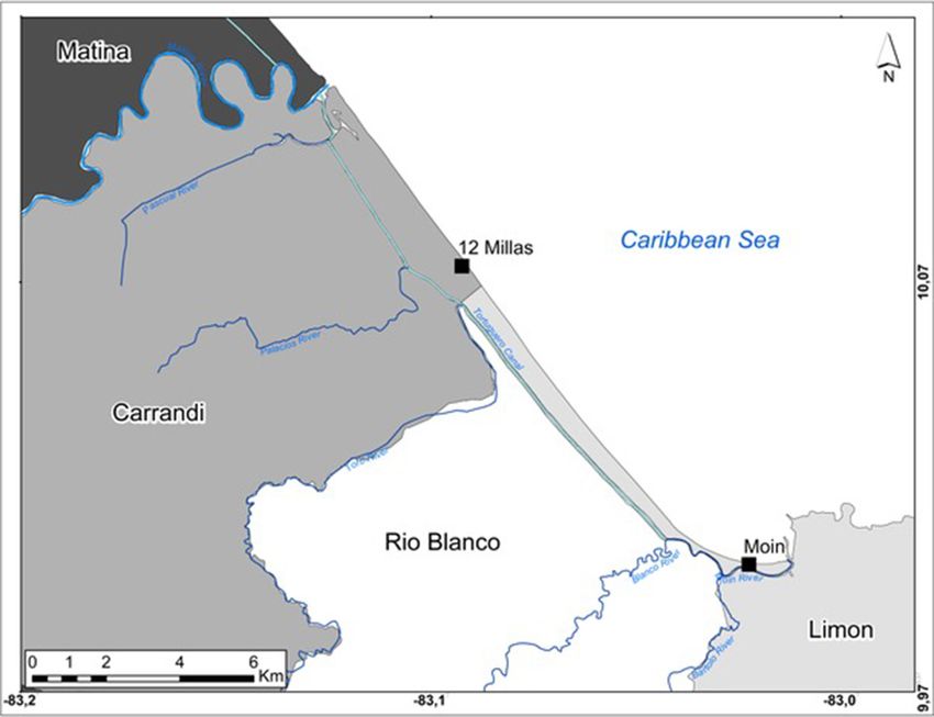
2                                              Revista Geológica de América Central

                                                      INTRODUCTION

     Since 1530 the Caribbean region has experienced at least 83 tsunamis caused from earthquake, volcano and landslide
producing at least 4,500 deaths (NOAA/NCEI, 2020). The most recent devastating tsunami occurred in 1946 in Dominican
Republic causing almost 2000 deaths and since then, the coastal population and touristic development in the region has
grown exponentially. However, it was until 2005 that it was established the Intergovernmental Coordination Group for
Tsunami and Other Coastal Hazards Warning System for the Caribbean and Adjacent Regions (ICG/CARIBE-EWS) of the
Intergovernmental Oceanographic Commission (IOC) of UNESCO. Costa Rica has been a member of the ICG/CARIBE-
EWS since the beginning, participating in trainings, Caribe Wave exercises and other activities to increase tsunami prepared-
ness at the Caribbean coast.
     However, tsunamis are scarce in Costa Rica and before 1991 were not considered a threat. The seismic threat on the
Caribbean coast was also underestimated by then, despite there were important earthquakes there in 1746, 1798, 1822, 1904,
1916 and 1953 (Boschini & Montero, 1994; Camacho & Víquez, 1993; González-Víquez, 1910; Montero, 1986, 1989;
Peraldo-Huertas & Montero, 1994; Peraldo & Montero, 2007). The 1991 Valle de la Estrella earthquake and tsunami triggered
research on historic events allowing to find new information, including the list of events above.
     At the 30th anniversary of the 1991 event, the authors present a summary of tsunami history for the Caribbean coast of
Costa Rica. This summary includes unpublished information related to 1991 tsunami and to previous events, discovered du-
ring the writing of the “Historical Tsunami Catalog for Costa Rica until 2020” (Chacón-Barrantes et al., in press).
     The Caribbean coast of Costa Rica has experienced two confirmed tsunamis and three probable tsunamis. All the records
correspond to local tsunamis. The 1991 tsunami is the one with more records associated in the country and had the highest
impact known so far, being the only one causing deaths.

                                                           METHODS

     Records of historical tsunamis can be found on marigrams, interviews with witnesses, scientific papers, books, and news-
papers. Limon tide gauge was installed in 1940 using paper rolls to record the sea level. Unfortunately, the paper rolls from
1940 to 1969 were destroyed thus we were not able to search for changes on sea level associated to the 1953 earthquake; and
in April 1991 the tide gauge was not working. In 2019 the authors interviewed the medical doctor Mayela Valerio. In 1991
she was one of the physicians issuing death certificates for the victims of the earthquake and the tsunami (Chacón-Barrantes
et al., in press).
     The authors performed an extensive bibliographic review of books on historical seismology (Peraldo-Huertas & Montero,
1994, 1999), papers on scientific journals (Boschini, 1989; Boschini & Montero, 1994; Boschini, Rojas, & Vargas, 2014;
Camacho, 1993, 1994; Camacho & Víquez, 1993; Nishenko, Camacho, Astorga, Morales, & Preuss, 2021; Peraldo & Montero,
2007; Suarez et al., 1995) and catalogs of historical tsunamis (Molina, 1997; NOAA/NCEI, 2020). Besides, we searched the
online database of newspapers of the National Library (SINABI, 2020) for reports of anomalous changes on sea level that
could be associated to tsunamis.
     The authors defined the following criteria to classify the tsunami events:
     • Confirmed: if there is at least one report of flood or sea retreat unquestionably associated to a seismic event.
     • Probable: if there is a report of abnormal sea behavior that very likely corresponded to a tsunami (can be associated
to an earthquake), but cannot be confirmed, more likely because could have an alternate explanation.

                                              RESULTS AND DISCUSSION

     There are reports of five tsunami events in the Caribbean coast of Costa Rica, with impact ranging from abnormal sea
behavior to deaths. Also, there were earthquakes in 1904 and 1953 with no tsunami record associated (Figure 1). From the
five tsunami events, the authors found new information related with three of them: 1746, 1916 and 1991. Previously, the 1916
tsunami had reports only at Panamá. The 1746 event had no report of tsunami associated until now. All the tsunami records

                                         RGAC, 2021, 65, 1-11, doi: 10.15517/rgac.v0i65.46694
Chacón, Murillo & Rivera: Historical Tsunamis at the Costa Rican Caribbean Coast 3
Fig. 1: Dates and impact of tsunamis at the Caribbean coast of Costa Rica. Black circles correspond to confirmed tsunamis, grey circles correspond to pro-
bable tsunamis and the white circle correspond to doubtful tsunami. The lines without circles correspond to earthquakes with no tsunami records associated.
correspond to locations south of Boca Matina, there are no records for the north Caribbean coast (Figure 1). This might be due
to sparse population, lack of preservation of the reports or absence of tsunami impact, which is unlikely.
It is not possible to establish a recurrence period of tsunamis in the Costa Rican Caribbean coast. There are only two
confirmed tsunamis with 169 years of difference. If all the earthquakes are considered, the time lapses are 52, 24, 82, 8, 37 and
38 years. The epicenter of the 1916 event was offshore Panamá (Figure 2), if we consider all the other earthquakes the time
lapses are 52, 24, 82, 49 and 38 years, but there is not possible to know if all the mentioned earthquakes had the same origin.
Only 1822, 1904, 1916 and 1991 are confirmed to correspond to North Panama Deformed Belt (NPDB) activity (Camacho &
Víquez, 1993), having time lapses of 82, 8 and 75 years. Also, there might be other events so far unknown.
In the following sections, the authors describe each tsunami event, giving its classification and including new information
when available. Events with no new information are also included for completeness.
21 June 1746 – Probable tsunami
The oldest tsunami record we were able to find corresponded to 1746, when the Interim Commander of San Fernando
Fort at the mouth of Matina river reported: “a hurricane came suddenly from the sea that put us in great horror and confusion
seeming to be the last days of life, taking in its first fury the house where the officers live leaving everything destroyed and
useless, as well as the gunroom […] presenting before this destruction an earthquake” (Peraldo & Montero, 2007, p. 34;
translated by the authors).
We think that this event very likely corresponds to a tsunami rather than a hurricane, considering that the earthquake
happened right before the “hurricane”. Also, the use of the verb “sobrevenir” in the original Spanish version, which defini-
tion is “to come suddenly” (RAE, 2014), indicates a sudden event rather than a sustained one, as it is the case of hurricanes.
Furthermore, the phrase “taking in its first fury the house where the officers live” suggest the arrival of several waves.
The concept of tsunami did not exist in the residents of Boca Matina at that date, which might explain the confusion.
As a reference, to our knowledge only four tsunamis had happened at America before that date: 1530 at Venezuela, 1690 at
Antigua, 1692 at Jamaica and 1700 at Cascadia (Pacific U.S.) (NOAA/NCEI, 2020) and the largest tsunami affecting Portugal
and Spain happened in 1755, nine years after this one.
Other authors indicate that the Fort of San Fernando, built in 1742, was partially destroyed by the 1746 earthquake
(Boschini & Montero, 1994), although the forementioned text makes reference to damages caused by the “hurricane” rather
than the earthquake. In 1747 the Fort was attacked and burned down by pirates, being totally destroyed (Boschini & Montero,
1994), as the damages caused by the “hurricane” were not likely repaired yet.
RGAC, 2021, 65, 1-11, doi: 10.15517/rgac.v0i65.466944 Revista Geológica de América Central
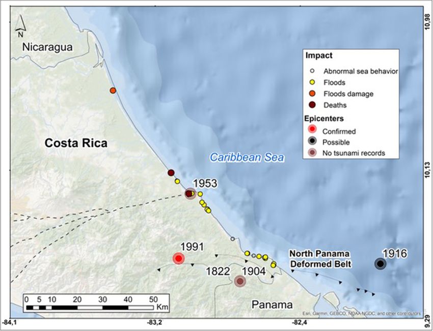
Fig. 2: Epicenters of earthquakes causing confirmed tsunamis (red stars), possible tsunamis (black star) and earthquake with no tsunami associated (brown
stars). Also are shown the tsunami records (colored dots) at Costa Rica Caribbean coasts. Basemap: Atlas ITCR (2014), tectonics: Protti et al. (2001), impact
and epicenters from Chacón-Barrantes et al. (2021).
This earthquake was not mentioned by González-Víquez (1910), who listed earthquakes in 1728 and 1756, and there is
only one report at one place and from one source associated to this event. It cannot be assured that the report corresponds to a
tsunami, as there are other possible explanations like a storm. Consequently, this event is classified as probable.
22 February 1798 – Probable tsunami
González-Víquez (1910) reproduces the report of earthquakes from the Commander of Matina on 22 February 1798, who
also said “since the earthquakes started, the sea is so restless that it seems is going to come over us” (p. 16; translated by the
authors). This description very likely corresponds to a tsunami but again could have an alternate explanation such as wind
waves. Also, there is only one report at one place and from one source and thus we classified this event as probable tsunami.
Although this event is referred to Matina, the correct location of the report is Boca Matina, the mouth of Matina river.
This event is included at the Tsunami Catalogue for Central America 1539-1996 (Molina, 1997) and the authors did not find
new information related to this event.
RGAC, 2021, 65, 1-11, doi: 10.15517/rgac.v0i65.46694Chacón, Murillo & Rivera: Historical Tsunamis at the Costa Rican Caribbean Coast 5
7 May 1822 – Confirmed tsunami
González-Víquez (1910) reports from historic papers that “in (Boca) Matina there were three violent shakes as no resi-
dent remember to had felt before; […] that the rivers and bay grew and caused floods” (p. 21; translated by the authors). The
flooding caused by rivers can be explained by plugging caused by landslides consequence of the earthquake, but the “grew”
of the bay and its subsequent flooding can only be explained as a tsunami.
The earthquake was also felt in Bocas del Toro (Camacho & Víquez, 1993) and a tsunami was reported in the same region
between 1820 and 1830, that might correspond to this one (Boschini & Montero, 1994). As there are two reports of the same
event in different places this tsunami is confirmed.
This earthquake was initially located at Osa region by Montero (1986), without discarding its Caribbean origin. The later
was confirmed by Boschini and Montero (1994) and Camacho and Víquez (1993) based on macroseismic studies and compa-
ration with the 1991 event, including liquefaction and tsunami reports. This tsunami is also included at the Tsunami Catalogue
for Central America 1539-1996 (Molina, 1997) and the authors did not find new information related to this event.
25 April 1916 (26 April 1916 UTC) – Probable report in Costa Rica of a confirmed tsunami in Panamá
After an earthquake on 25 April 1916 “A small tsunami throw litter and canoes some two hundred meters ashore”
(Camacho & Víquez, 1993, p. 63) in Bocas del Toro, Panamá; other reports indicated that “sea flowed over knee deep into the
land” (Camacho & Víquez, 1993, p. 61).
In the Costa Rican newspaper “La Información” of 29 April there is an interview to Dr. Roberto Jiménez Ortiz, who was
at “the Costa Rican town of Sixaola” at the time of the earthquake and said: “right at that moment, the waters of the mighty
and wide river that divides both territories, surpassed their banks and loud rumbles were heard also in the depths of the water,
those noises produced by something like big subterraneous dislocation or the crash of thousand stones agitated by furious
currents” (“La Catástrofe En Bocas Del Toro, Almirante y Sixaola”, 1916, p. 4).
Currently, Sixaola is located at more than 18 rkm (river-kilometer, distance along a river from its mouth) and more than
11 km from the sea in a straight line. It is a long distance, but it is common to observe tsunami induced changes on rivers at
very long distances inland. For example, in 1983 a Mw=7.8 earthquake in Noshiro, Japan was observed up to 15rkm. Also,
the 1941 Osa tsunami in the Pacific coast was reported in Puerto Cortés, located at 15rkm.
The earthquake occurred during nighttime, hindering possible further observations of the river, like changes of flow di-
rection and observations in the coast. We consider this report at Sixaola as probable, as it might have an alternate explanation,
but the most likely is the tsunami. This is a confirmed tsunami in Panamá.
22 April 1991 – Confirmed tsunami
This event and the Nicaragua Mw 7.6 tsunami-earthquake occurred in September 1992, launched regional earthquake and
tsunami research in Central America, resulting in the first tsunami catalogue for the region (Molina, 1997).
There were no seismographers in the region in 1991 (“Terremoto En Limón”, 1991) and the tide gauge in Limón was not
working that day. The tsunami was registered at three tide gauges in Coco Solo (Panamá), Magueyes Island (Puerto Rico)
and Limetree (US Virgin Islands), with a maximum height of 76 cm in Panamá and 7 cm at the other two locations (NOAA/
NCEI, 2020).
Even when the 1991 event was the tsunami with the highest impact in Costa Rica (Chacón-Barrantes et al., 2021), it
was unnoticed by the rest of the country. Costa Rican newspapers informed that a tsunami occurred in Panamá. For example,
Diario Extra (“Terremoto Dejó Muertos En Panamá”, 1991, p. 9) wrote: “Bocatoreños (…) were seen moving to highlands to
escape the big waves that hit the lower parts of the islands.” La República (“Terremoto Afectó La Mitad de Centroamérica”,
1991, p. 11A) wrote: “In the archipelago of Bocas del Toro (...) there was a small surge due to the earthquake”.
RGAC, 2021, 65, 1-11, doi: 10.15517/rgac.v0i65.466946 Revista Geológica de América Central
La Nación used a full page to report the consequences of the earthquake and tsunami in Panamá. The article “What a
disaster!” included an aerial photograph of the tsunami damages with the caption “A strong surge “washed” the vicinity of the
dock in Puerto Almirante. Desolation and havoc everywhere” (Martínez, 1991, p. 10). It also said: “The berth in Almirante is
partially damaged and, nearby, bared land with only a few houses standing or damaged by the strong surge that hit the place
on Monday afternoon” (Martínez, 1991, p. 10).
The second article “Death and damages at Panamanian province” has more information about the tsunami:
Colón, the main island of the Bocas del Toro Archipelago, was badly affected by the earthquake, which was fo-
llowed by a small tsunami that destroyed 72 homes, killed one person and injured another, according to reports
from the Public Force.
The strong storm surge flooded the provincial capital - Bocas del Toro - and destroyed the main pier, which pre-
vented the arrival of the only ferry that connects it with the rest of the province (“Muerte y Daños En Provincia
Panameña”, 1991, p. 10).
Despite this much information about the tsunami in Panamá, the newspapers made no reference to the tsunami in Costa
Rica. We guess severe and widespread damages of the earthquake overshadowed the tsunami impact.
Costa Rica had no central database of deaths at that date (Chacón-Barrantes et al., 2021), therefore it was not possible
to separate the deaths caused by the tsunami from the deaths caused by the earthquake. The newspapers reported contra-
dictory death figures from the earthquake (“¡Temblor... Todos Fuera!”, 1991; “Crece La Tragedia”, 1991; “Destrucción y
Muerte En El Atlántico”, 1991; “Dos Muertos”, 1991; “Limón Contaba Anoche Sus Primeros Muertos”, 1991; “Limón Quedó
Semidestruido”, 1991; “Miles de Kilómetros de Dolor y Muertes”, 1991; “Muertes Por Terremoto”, 1991; Pérez, 1991).
The main causes of death they listed were injuries from falling objects and crushing due to buildings collapse (“Crece La
Tragedia”, 1991).
Nishenko et al. (2021) performed a post-tsunami survey, even when the concept of such was developed after the 1992
Nicaragua and 1992 Flores tsunamis. The first edition of the Post Tsunami Survey Field Guide from IOC/UNESCO was
published in 1998 (UNESCO/IOC, 2014). Nishenko et al. (2021) reported tsunami records at 12 locations in Costa Rica and
14 in Panamá, including runup heights and inundation distances for most of them. Also, Plafker and Ward (1992) reported
tsunami records at 10 locations in Costa Rica, for some of them they reported arrival times of between 3 and 5 minutes after
the earthquake.
Unfortunately, the 1991 archives from the Costa Rican police were lost and there was not an official report of deaths
for this earthquake and tsunami. Nishenko et al. (2021) reported two deaths associated to this tsunami in Doce Millas. They
mistakenly stated Doce Millas as part of Moín, but it belongs to Carandí district of Limón (Figure 3).
We interviewed Dr. Valerio, she issued one death certificate for one person drowned by the tsunami in Moín, this body
was recovered from the sea. She also remembers at least one more person drowned certified by a colleague but was not able to
remember the place. As Moín and Doce Millas are 8.5 km apart (Figure 3), both references very likely do not refer to the same
two persons, and then this tsunami might have caused three or four deaths. Dr. Valerio also mentioned that she met two tourists in
Limón, who had been rescued from the sea, as they almost perish in the tsunami, but did not know the exact place of the rescue.
No other tsunami had caused deaths in Costa Rica; therefore, the testimony of Dr. Valerio is very valuable, particularly as
there is the only information specifically related to deaths caused by a tsunami in Costa Rica.
OTHER EARTHQUAKES INVESTIGATED
20 December 1904 (19 December 1904 UTC)
As the 1822 earthquake, the 1904 earthquake was initially located at the Osa region by Pacheco and Sykes (1992) and
relocated in the Costa Rican Caribbean coast by Boschini and Montero (1994), Camacho and Víquez (1993) and Ambraseys
and Adams (1996). This relocation was done for the same reasons as the 1822 earthquake: intensity and damage reports, as
well as the report of coastal uplift at Limón.
RGAC, 2021, 65, 1-11, doi: 10.15517/rgac.v0i65.46694Chacón, Murillo & Rivera: Historical Tsunamis at the Costa Rican Caribbean Coast 7
Fig. 3: Location of 12 Millas and Moín, showing the distance between different reports of deceased people by the tsunami. Matina, Carrandi, Río Blanco and
Limón are districts of Limón. Basemap: Atlas ITCR (2014), Tortuguero channel digitized from Open Street Maps.
There is no information of a tsunami related to this earthquake. However, Calvert and Calvert (1917) visited the hospital
at Limon in 1909 guided by Dr. Emilio Echeverría and reported: “The coast here consists of a coral rock which forms cliffs,
reaching a height of a hundred feet in some places, and flat reeds which are washed by the tide. Dr. Echeverria thought the
reefs were still forming, as a certain reef now visible, although awash, was not so when he first came to the hospital” (p. 5).
The rise on the reefs might be a sign that a tsunami was generated, but this cannot be established. Camacho and Víquez
(1993) indicated this rise of the reefs is consistent with the caused by the 1991 event, confirming that this earthquake was ori-
ginated at the North Panama Deformed Belt (NPDB). Also Ambraseys and Adams (1996) located them in the Caribbean coast.
The Engdahl and Villaseñor catalog (2002) locate the 1904 event at the Osa region based on Pacheco and Sykes (1992)
without considering newer data. However, in personal communication with Dr. Javier Pacheco in 2020, he stated that the valid
location of 1904 event is the newest one, provided by Camacho and Víquez (1993), as it was calculated with newer informa-
tion than Pacheco and Sykes (1992).
In newspapers of 1904, all the references of damages caused by the earthquake are concentrated at the Atlantic region of
Costa Rica (Briceño, Ispizún & Martínez, 1904; Castro, 1904; “El Temblor Por El Telégrafo Sin Hilos”, 1904; “Los Temblores
En La Línea de Limón”, 1904; “Severe Earthquake in the City”, 1904; Saborío & Alabarta, 1904). For example several news-
papers reported on the damages on the railroad that prevented the opera company to arrive to San José to performed as planned
(Castro, 1904; Saborío & Alabarta, 1904).
Several newspapers reported that residents of Limon haven’t felt such a strong earthquake before, like the newspaper El
Día: “It was an atrocious thing and people that have lived here for like 30 years assured me that they have never felt anything
like it” (“Los Temblores En La Línea de Limón”, 1904, p. 2; translated by the authors).
RGAC, 2021, 65, 1-11, doi: 10.15517/rgac.v0i65.466948 Revista Geológica de América Central
Also, the Limon Weekly News, which was “the only paper published in English in Costa Rica”: “At midnight on Monday
the entire city was thrown into a state of alarm by a very severe shock of earthquake, the like of which had never been expe-
rienced in Port Limon by the oldest inhabitant” (“Severe Earthquake in the City”, 1904; p. 4).
From Panamá the newspaper “El Noticiero” reported that there were damages in Bocas del Toro:
Immediately after the earthquake, in a communication from Bocas del Toro to Limón through the wireless
telegraph, mentioned that there the earthquake was of great proportions. Some buildings were damaged. The
residents are extremely alarmed.
From the warship ‘Dixon’ anchored in Bocas del Toro waters, they communicate also by the wireless telegraph,
that it felt very strong on board and the marines were scared (“El Temblor Por El Telégrafo Sin Hilos”, 1904,
p. 3; translated by the authors).
But no damages were reported in Chiriquí, the Panamá province at the border with Costa Rica in the Pacific coast
(Camacho & Víquez, 1993).
Also, there are no references at all to damages in the south part of Costa Rica, in a similar way as done for the 1953 event.
As opposite, newspapers entries related with the 1941 earthquakes include wide reports of damages in the south part of the
country and only minor reports for the Atlantic region.
7 January 1953
On 7 January 1953 a Mw=5.9 earthquake shook Costa Rica with epicenter in Limón city (Boschini & Montero, 1994)
and maximum intensity of VIII, newspapers reported people falling down in the streets due to the shaking (Martín, 1953). The
earthquake caused important damages in the city and subsidence of several inches at several parts of the airstrip (Borrasé &
Durán, 1953). Residents of Limón reported rumbles the days previous to the earthquake (“La United Fruit Company Informa
Sobre El Terremoto de Limón”, 1953; Martín, 1953). There are no other reports of this earthquake along the Caribbean coast
and neither tsunami reports, as the paper rolls of the tide gauge of that year are lost.
CONCLUSIONS
Costa Rica Caribbean coast has experienced at least four local tsunamis since 1746. There are no records of distant tsu-
namis and no marigrams, even when Limon tide gauge was installed in 1941. The 1991 tsunami caused at least three deaths,
being the one with the largest impact for both Costa Rican shores. Also, the 1991 tsunami had the maximum number of regis-
ter locations in the country.
Nowadays, Costa Rica has only one tide gauge at the Caribbean coast, located in JAPDEVA port. The authors consider
necessary to have more tide gauges at this coast to register future tsunamis. Tsunami marigrams are required for numerical
model verification and to better understand the tsunami physical response of the region.
In regions with infrequent occurrence of tsunamis like the Caribbean basin, tsunami historical records become key on
acknowledging and assessing the threat. Even when a recurrence time cannot be established, it is for sure that a tsunami will
impact again the Caribbean coast of Costa Rica, thus tsunami preparedness should be increased, both by national and local
authorities and by coastal communities.
RGAC, 2021, 65, 1-11, doi: 10.15517/rgac.v0i65.46694Chacón, Murillo & Rivera: Historical Tsunamis at the Costa Rican Caribbean Coast 9
ACKNOWLEDGMENTS
This research was performed by SINAMOT Program of the Universidad Nacional, Costa Rica, as part of the elaboration
of the “Historical Tsunami Catalog for Costa Rica until 2020” which is in press. The authors want to thank M.Sc. Walter
Montero Pohly and Dr. Percy Denyer for the exchange of emails and the information provided regarding the XVIII century
events. The authors want to thank the reviewer Dr. Eduardo Camacho for his valuable corrections that considerably improved
the quality of the paper and for so many conversations about the 1991 tsunami over the years.
REFERENCES
Mora, E. (1991, April 23). ¡Temblor... todos fuera! (1991, April 23). La Nación, p. 2.
Ambraseys, N. N. & Adams, R. D. (1996). Large-magnitude Central American earthquakes, 1898-1994. Geophysical Journal
International, 127(3), 665–692. https://doi.org/10.1111/j.1365-246X.1996.tb04046.x
Borrasé, A. & Durán, L. (1953, January 8). Hoy en la madrugada tembló otra vez fuertemente en Puerto Limón. La Prensa
Libre, p. 10.
Boschini, I. (1989). Incidencia de las fuentes sísmicas en la región Caribe de Costa Rica. Revista Geológica de América
Central, 11, 109-109.
Boschini, I. & Montero, W. (1994). Sismicidad histórica e instrumental del Caribe de Costa Rica. Revista Geológica de
América Central, Volumen Especial: Terremoto de Limón, pp. 65–71.
Boschini, I., Rojas, W. & Vargas Villalobos, A. (2014). Catálogo de los sismos más relevantes en la historia de Costa Rica.
RSN. Unpublished manuscript.
Briceño, L., Ispizún, S. & Martínez, M. (1904). Los temblores en las faldas del Turrialba. El Noticiero, p. 3.
Calvert, A. S. & Calvert, P. P. (1917). A year of Costa Rican natural history (First). The Macmillan Company.
Camacho, E. (1993). The tsunami of April 22, 1991 in Central America. Tsunami Newsletter, XXV(1), 6–7.
Camacho, E. (1994). El tsunami del 22 de abril de 1991 en Bocas del Toro, Panamá. Revista Geológica de América Central,
Volumen Especial: Terremoto de Limón, 61–64.
Camacho, E., & Víquez, V. (1993). Historical Seismicity of the North Panama Deformed Belt. Revista Geologica de America
Central, 15, 49–64.
Castro, M. (1904). Crónica - Ferrocarril. El Derecho, p. 3.
Chacón-Barrantes, S. E., Murillo-Gutiérrez, A. & Rivera-Cerdas, F. (2021). Catálogo de Tsunamis Históricos de Costa Rica
hasta el 2020 (1st ed.). EDUNA.
Crece la tragedia. (1991, April 24). La Nación, p. 3.
Destrucción y muerte en el Atlántico. (1991, April 23). La Nación, p. 5.
RGAC, 2021, 65, 1-11, doi: 10.15517/rgac.v0i65.4669410 Revista Geológica de América Central
Dos Muertos. (1991, April 23). Diario Extra, p. 2.
El temblor por el telégrafo sin hilos. (1904). El Noticiero, p. 3.
Engdahl, E. R. & Villaseñor, A. (2002). 41 Global seismicity: 1900-1999. International Geophysics, 81(PART A), 0–12.
https://doi.org/10.1016/S0074-6142(02)80244-3
González-Víquez, C. (1910). Temblores, terremotos, inundaciones y erupciones volcánicas en Costa Rica 1608-1910.
Tipografía de Avelino Alsina.
Instituto Tecnológico de Costa Rica (ITCR). (2014). Atlas de Costa Rica. Cartago. Ortiz-Malavasi, E. (Coord.). (2014). Atlas
digital de Costa Rica. Cartago [Data assamblage]. ITCR.
La catástrofe en Bocas del Toro, Almirante y Sixaola. (1916, April 29). La Información, p. 4.
La United Fruit Company informa sobre el terremoto de Limón. (1953, January 9). La República, p. 7.
Limón contaba anoche sus primeros muertos. (1991, April 23). La Nación, p. 8.
Limón quedó semidestruido. (1991, April 23). La República, p. 4A.
Los temblores en la línea de Limón. (1904, December 22). El Día, p. 2.
Martín, T. (1953, January 8). Completa Información sobre los Daños Causados en Limón por el Temblor de Ayer. La República.
Martínez, M. (1991, April 24). “¡Qué desastre!”. La Nación.
Miles de kilómetros de dolor y muertes. (1991, April 23). La Nación.
Molina, E. (1997). Tsunami Catalogue for Central America 1539-1996. Institute of Solid Earth Physics, University of Bergen.
Technical Report No. II 1-04.
Montero, W. (1986). Períodos de recurrencia y tipos de secuencias sísmicas de los temblores interplaca e intraplaca en la
región de Costa Rica. Revista Geológica de América Central, 5, 35–72.
Montero, W. (1989). Sismicidad Histórica de Costa Rica 1638-1910. Geofísica Internacional, 28(3), 531–559.
Muerte y daños en provincia panameña. (1991). La Nación, p. 10.
Muertes por terremoto. (1991, April 23). Diario Extra, p. 5
Nishenko, S. P., Camacho, E., Astorga, A., Morales, L. D. & Preuss, J. (2021). The 22 April 1991 Limón, Costa Rica Tsunami
Field Survey. Revista Geológica de América Central, 30 aniversario del terremoto de Limón (1991-2021), en este
volumen.
NOAA/NCEI. (2020). National Geophysical Data Center / World Data Service: NCEI/WDS Global Historical Tsunami
Database. NOAA National Centers for Environmental Information. https://doi.org/10.7289/V5PN93H7
RGAC, 2021, 65, 1-11, doi: 10.15517/rgac.v0i65.46694Chacón, Murillo & Rivera: Historical Tsunamis at the Costa Rican Caribbean Coast 11
Pacheco, J. F. & Sykes, L. R. (1992). Seismic Moment Catalog of Large Shallow Earthquakes, 1900 to 1989. Bulletin of the
Seismological Society of America, 82(3), 1306–1349.
Peraldo-Huertas, G., & Montero, W. (1994). Temblores del período colonial de Costa Rica (1st ed.). Cartago: Editorial
Tecnológica de Costa Rica.
Peraldo-Huertas, G. & Montero, W. (1999). Sismología Histórica de América Central (1st ed.). México: Instituto Panamericano
de Geografía e Historia.
Peraldo, G. & Montero, W. (2007). Temblores documentados para el periodo colonial de Costa Rica. Revista Geologica de
America Central, 36, 25–47.
Pérez S., R. (1991, April 23). Tres muertos en Bataan. Diario Extra.
Plafker, G. & Ward, S. N. (1992). Backarc thrust faulting and tectonic uplift along the Caribbean Sea coast during the April
22, 1991 Costa Rica earthquake. Tectonics, 11(4), 709–718.
Protti, M., Güendel, F. & Malavassi, E. (2001). Evaluación del potencial sísmico de la Península de Nicoya. EFUNA.
Real Academia de la Lengua Española (RAE). (2014). Diccionario de la lengua española (23rd ed.). Retrieved from https://
www.rae.es/diccionario-de-la-lengua-espanola/la-23a-edicion-2014
Saborío, A. & Alabarta, J. (1904). Crónica del día. El Heraldo de Costa Rica, p. 3.
Severe Earthquake in the City. (1904, December 24). Limon Weekly News, p. 4. Retrieved from https://www.sinabi.go.cr/ver/
biblioteca digital/periodicos/limon weekly news/limon weekly news 1904/lx-24 de diciembre.pdf#.X1fe-i1t-wU
SINABI. (2020). Base de Datos de Periódicos en Línea. Retrieved from www.sinabi.go.cr website: http://www.sinabi.go.cr/
contextual/busqueda.aspx?tipobuscador=4#%23%23
Suarez, G., Pardo, M., Dominguez, J., Ponce, L., Montero, W., Boschini, I. & Rojas, W. (1995). The Limon, Costa Rica ear-
thquake of April 22, 1991: Back arc thrusting and collisional tectonics in a subduction environment. Tectonics, 14(2),
518–530.
Terremoto afectó la mitad de Centroamérica. (1991, April 23). La República, p. 11A.
Terremoto dejó muertos en Panamá. (1991, April 23). Diario Extra, p. 9.
Terremoto en Limón. (1991, April 23). Diario Extra, p. 4.
UNESCO/IOC. (2014). International Tsunami Survey Team (ITST) Post-Tsunami Survey Field Guide. UNESCO.
RGAC, 2021, 65, 1-11, doi: 10.15517/rgac.v0i65.46694You can also read