The City Circuit Drive - A self drive tour of the City of Gladstone - for more information visit
←
→
Page content transcription
If your browser does not render page correctly, please read the page content below
The City Circuit Drive
                                A self drive tour of the City of Gladstone

for more information visit
gladstoneregion.info
facebook.com/gladstoneregion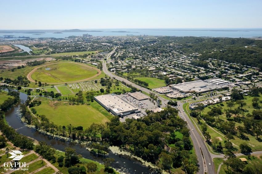
GLADSTONE VISITOR INFORMATION CENTRE
Marina Ferry Terminal, 72 Bryan Jordan Drive
Gladstone QLD 4680
                                                07 4972 9000

AGNES WATER VISITOR INFORMATION CENTRE
71 Springs Road
Agnes Water QLD 4677
                                                07 49702 1533

MIRIAM VALE VISITOR INFORMATION CENTRE
Roe Street (corner Bruce Highway)
Miriam Vale QLD 4677
                                                07 4974 5428

TANNUM SANDS VISITOR INFORMATION CENTRE
25 Ocean Street
Tannum Sands QLD 4680
                                                07 4973 8062

                   For more information visit
                      gladstoneregion.info
                 facebook.com/gladstoneregion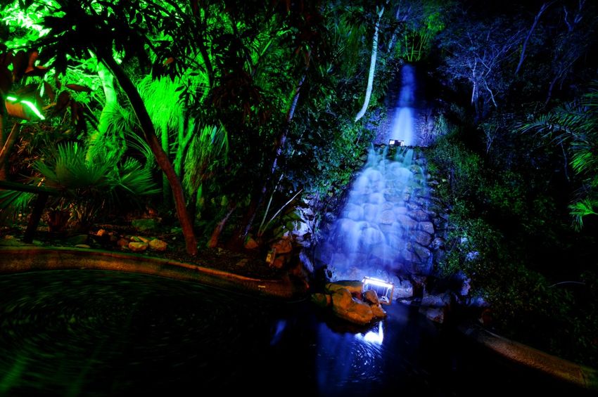
INTRODUCTION
The City Circuit Drive is a pleasant way to explore Gladstone. In nine sections, it outlines a self-drive tour cover-
ing many of the city’s attractions and features. While the tour starts and ends at the Gladstone Visitor Informa-
tion Centre at the Marina, the circuit can be joined at any point.
Highlights of the route include:
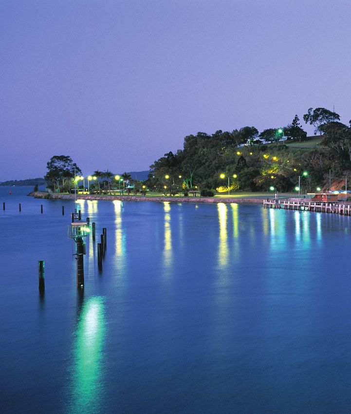
Spinnaker Park and Gladstone Marina Parklands
Callemondah
Round Hill Lookout
Kin Kora
Tondoon Botanic Gardens
Gecko Valley Winery
Queensland Alumina
Barney Point Beach
City Centre
Auckland Inlet
The drive is some 42kms, and a continuous drive takes about one hour, however stops along the way will add
considerably to this. Distances are approximate and do not include optional diversions which may vary in
length. Some aspects of the route are not recommended for towed caravans and will be noted.
In the unlikely event of a problem along the way, the following may be appropriate;
Emergency 000 Ambulance 13 1233
Police RACQ 4972 3911
Gladstone 4971 3222 24hr Roadside Assistance 131 111
Calliope 4975 7210
Tannum Sands 4973 7866
Miriam Vale 4974 5155
Agnes Waters 4974 9708
Theodore 4993 1222
Gladstone Marina via Spinnaker Park to Callemondah
                                                Section Distance 7.1k

The Marina harbours the charter board and fishing fleet, and is the anchorage for many local visiting craft. The
terminal building houses the Gladstone Visitor Information Centre and is the departure point for reef trips and
the Heron Island Resort. The complex includes a bait and tackle shop, boardwalk, parkland and barbecues.
Nearby is the Gladstone Campus of CQ University

From the Marina car park, drive west along Bryan Jordan Drive. CAUTION: 40km per hour speed limit is in place
throughout the Marina. After 0.7km turn right at the roundabout onto Alf O’Rourke Drive and proceed to Spin-
                                                  naker Park.

On your right as you leave the Gladstone Marina are the commercial fishing anchorages, slipway and seafood
processing facilities, with Mission to Seafarers on the corner. To the front right is the Gladstone Ports Corpora-
tion R.G. Tanna Coal Terminal—Queensland’s largest multi commodity port which handles in excess of 83Mt of
cargo annually.

Marking the official finish line for the Brisbane to Gladstone Yacht Race, Spinnaker Park offers two and a half
kilometres of walking tracks, native wetlands, landscaped picnic areas, barbecue facilities and beached cove.

      Leaving Spinnaker Park, proceed straight ahead through the roundabout along Alf O’Rourke Drive.

On your right as you near the Hanson Road intersection are extensive NRG Gladstone Power Station reclama-
tion and re-vegetation areas. In the distance is the imposing 632 metre high Mount Larcom, often referred to as
the ‘sleeping giant’ or ‘facing lions’.

                                   Callemondah to West Gladstone
                           Section Distance 2.3k               Progressive Distance 9.4k

At the roundabout the Callemondah Industrial Estate lies in front f you, including the Austicks plant where quality
icecream sticks are produced from plantation timber. The Industry here is Queensland’s largest power station, NRG
Gladstone Power Station, located beside the Calliope River. Take advantage of a FREE Industry Tour to NRG by book-
ing in advance through the Gladstone Visitor Information Centre.

For a closer drive past the Power Station, turn right at the roundabout. Return to the circuit by completing a u-turn
on the underpass at NRG and then making a right turn at the roundabout

To continue on the circuit, proceed straight through the roundabout into Blain Drive which will take you into West
Gladstone.

The Auckland Creek Environmental Zone is found along Blain Drive and on your right is Boowan Park which starts a
walking trail around Lake Callemondah. Across the creek bridge on the left is Bulgwoyn Park with a viewing point for
a seasonal colony of fruit bats. Both areas have cark parks. Ahead on the left is the Palm Drive Junior Sports Facility
with Ferguson Park, Gladstone Turf Club on the right.

            CAUTION: Please note the marked rail crossing as you approach the Racecourse roundabout.
West Gladstone via Round Hill to Kin Kora
                                Section Distance 6.1k         Progressive Distance 15.5k

PLEASE NOTE: Round Hill Lookout is NOT recommended for towed caravans.

At the racecourse roundabout turn left onto Dawson Highway for a visit to Gladstone’s premier panoramic look-
  out. At the second set of lights, turn right onto Breslin Street. At the next set of lights, turn right onto Boles
                                      Street and continue along the drive up.

The short ascent takes you to Round Hill, high above Gladstone, for a magnificent 360 degree view. Look south
to Boyne Island and Tannum Sands, east to the Harbour and Industry, north to the City Centre and Islands and
west to the airport and suburbia. Access to the television and radio towers at the summit of Round Hill is not
permitted.

 To rejoin the circuit, descent the hill, turn left at the first traffic lights and then left at the next set of lights. This
  will take you back onto Dawson Highway. At the racecourse roundabout, continue straight ahead to the Kin
                                                     Kora roundabout.

To your left is Chanel College, one of Gladstone’s four high schools. To the right is Gladstone’s original ceme-
tery with many historic headstones and monuments. You will then approach the city’s main suburban shopping
Centre, Stockland Kin Kora Centre. Woolworths, Big W and a number of stores are on the left, with Coles, Tar-
get and Kmart on the right.

 To divert west to newer housing developments and the Gladstone Airport, proceed ahead through the round-
                      about. To rejoin the circuit, return to the roundabout and turn right.

                               Kin Kora to Tondooon Botanic Gardens
                                Section Distance 5.1k         Progressive Distance 20.6k

 The circuit turns left at the large Kin Kora roundabout (a Tobruk War Memorial), proceeding along Philip Street.
  Continue through the traffic lights to the large Sun Valley roundabout where you will turn right into Glenlyon
         Road. Drive straight ahead and continue through the Dalrymple Drive/Dixon Drive roundabout.

The modern Uniting Church building is on the right handside as you approach the Dalrymple/Dixon intersection. The
entrance to the Tondoon Botanic Gardens is ahead on the right. The Gardens, with its adjacent lagoon is a fine ex-
ample of Australian flora. There is good level walking access, a café, playground, Japanese tea gardens and barbecue
facilities. A steady hill climb up Mt Biondello is optional.

                             Tondoon Gardens to Gecko Valley Winery
                                    Section Distance 1k Progressive Distance 21.6k

Exit the Gardens ad turn right onto Glenlyon Road. Follow the road approximately 100m and turn right at the
Gecko Valley signed entrance onto Bailiff Road. Continue for 800m

Tour Central Queensland’s premier vineyards and sample some of the quality wines on offer.

Rose Garden Café Opening Hours
                             Wednesday — Friday
                             11am — 3pm
                             Saturday and Sunday
                             11am — 4pm
Gecko Valley to Queensland Alumina Ltd
                                    Section Distance 6.4k       Progressive Distance 28k

     Leaving Gecko Valley, return to the Dalrymple roundabout and turn right. Follow the winding drive to the main T-
                         intersection with Benaraby Road and turn left, back towards the City.

As you drive through the Toolooa Housing Estate and light industrial area you will have a view to Gatcombe Head at the
Harbour entrance.

At the Toolooa roundabout, drive straight ahead and shortly after, at the next roundabout, turn right at the refinery round-
                   about. Drive toward QAL and turn right at the access point for the visitor lookout.

The QAL lookout presents a panoramic view of Queensland Alumina — one of the world’s largest Alumina refineries,
Signboards explain the operations and the refining process of the plant. Further information is available at the administra-
tion building back down the hill and to the right. There is also the opportunity to take part in a FREE Mine to Market Indus-
try Tour which visits QAL and Boyne Smelters Ltd. Bookings are essential and can be made at the Gladstone Visitor Infor-
mation Centre.

                            Queensland Alumina Ltd to Barney Point Beach
                                   Section Distance 3.9k       Progressive Distance 31.9k

Turn left at the foot of the lookout hill and then turn right before the rail overpass. Follow this road through to Bell Street
and then turn right. At the end of Bell Street, turn left onto Sutton Street. Proceed three blocks and crossing Friend Street,
drive ahead to the carpark.

Driving to Barney Point, on the right handside is a large natural salt flat owned by QAL and used as a buffer zone. Then,
the Yaralla Sports Club and Mercure Hotel (left) and through the housing areas representing several generations. On the
left is Friend Park and Barney Point Beach— the historic site of the first landing in the Harbour, where a settlement was
formed in 1847. Look for historical plaques and Gladstone’s earliest grave. Around the rocky headland to the south is Fed-
eration Trail. Along the beach, a tidal flowing enclosure provides safe summer swimming. Parking and barbecues are
available. Beyond the northern end of the beach is a coal export facility.

                                                                                        QAL Salt Flats
Barney Point to Gladstone City Centre
                                 Section Distance 6.2 k    Progressive Distance 38.1k

  Right turn into Friend Street, then turn right again into Barney Street for one block, left into Young Street and
  across two rail overpasses to Toolooa Street. Turn left onto Toolooa Street at the lights and drive for several
                                                        blocks.

This will bring you to the Toolooa Village Shopping Centre— major rail lines,into Gladstone and Yaralla Sports
Club will be to the left. Continue along to the Derby Street intersection, where South Gladstone State Primary
School in on the right.

Turn right at the lights onto Derby street and continue along to the first set of lights (in the right lane). Turn right
      onto Glenlyon Road and continue to the next set of lights where you will turn right onto Tank Street.

This section of the circuit includes interesting highlights of Gladstone, including the Central Queensland Insti-
tute of TAFE and athletics oval on the left. Along Glenlyon Road you are driving through the southern Green Belt
— a major facility of parkland, sport and recreation created during the City’s rapid growth years in the 1970s.
Barbecues, playground, a swimming pool, fitness station and hillside fitness trail.

Turning into Tank Street, the Gladstone Bowls Club is on the right, beside Anzac Park where the City’s War Me-
morial Cenotaph is located. Also along Tank Street Is the Centro Valley Shopping precinct, ending at the Rail-
way Station.

     One block onto Tank Street, turn left at the roundabout onto the City’s main street, Goondoon Street.

City Centre points of interest

Block One   Centro Valley and Palms Shopping Fair on the right and Star of the Sea Catholic Church and
            Primary School on the left.
Block Two Centrelink, carwash and Lincraft on the right
Block Three On the right corner you will find the Gladstone Regional Art Gallery and Museum which is open
            Monday to Saturday from 10am. To the left is St Andrews Presbyterian Church.
Block Four This is a one-way drive-through Mall. Gladstone Regional Council Chambers are midway on the
            left. Here you will also find Retail Shopping, Banks, Café’s and Restaurants.

Off Street parking is available.

                                                                   Goondoon Street City Centre
City Centre to Auckland Inlet
                               Section Distance 2.6k        Progressive Distance 40.7k

Block Five    On the left corner is the restored Grand Hotel and to the right (set back mid-block) is the Gladstone
              Entertainment Centre. Currently (2013) the Centre is undertaking impressive renovations and has
              temporarily relocated to the Gladstone Marina. At the end of the block on the left is the former
              Post Office, and Kullaroo House to the right, which was beautifully restored by Gladstone Ports
              Corporation. FREE Industry Tours are available to Gladstone Ports Corporation.

   Drive ahead to Yarroon street, turn right and after one block, turn left along Auckland Street which enters
          Bishops Drive—a one way entry to Auckland Point lookout and parklands on Auckland Hill

This segment passes the distinctive and modern Gladstone Ports Corporation headquarters on the right, the old
and new Court House and Police Station on the left.

William Golding Memorial Lookout and observation deck overlook the Auckland Point Wharf Terminals, han-
dling gain, petroleum products, minerals, wood chip and containers, and presents views north to the Marina and
upper-harbour industry, east to the Islands and south to the harbour entrance. The Outlook Café on Auckland
Hill is open sporadically throughout the year, so please phone ahead 07 4972 1516. Near the lookout is the top
of a cliff-face waterfall and a 111-step walk down to Auckland Inlet and playground.

To leave the hill, use the one-way exit and veer left onto Harbour Terrace. At the rail overbridge, turn right at the
  CITY sign. Not two stop signs. Follow the road and take the next left under the bridge onto Flinders Parade.
                               Proceed around the base of Auckland Hill to the left.

Public Access to Auckland Point Wharf Terminals is NOT permitted.

                                    Auckland Inlet to Gladstone Marina
                               Section Distance 1.7k         Progressive Distance 42.4k

 Drive parallel to the creek until the road curves left near the Gladstone Yacht Club and becomes the lower end
                                                 of Goondoon Street

On the left is a landscaped waterfall developed by the Rotary Club of Gladstone (and is a spectacular sight at night)
and a walk to the top of the Auckland Hill. Auckland Inlet was the location of the first sailing ship trade into the Cit,
and today is an anchorage point for small craft. To the right is O’Connell Wharf, the Volunteer Marine Rescue Cen-
tre, a large public boat ramp and the Gladstone Yacht Club.

In lower Goondoon Street, take the first right turn onto Lord Street. At the roundabout take the third exit and cross
the bridge. Follow Bryan Jordan Drive until you reach the starting point at the Gladstone Visitor Information Centre.

The fountain beside the Gladstone Yacht Club commemorates the historic vessel, Lady Nelson. This was the supply
vessel accompanying the Flinders voyage along the east coast of Australia. Crossing Auckland Inlet is the Matthew
Flinders bridge which raises hydraulically to permit tall vessel passage. To the right is an open air stage and festival
area. Further along to the left is the Gladstone campus for CQ University. The Gladstone Visitor Information Centre
is next on the right.

                                                                      Auckland Hill Waterfall
You can also read