A Slow Way from Hereford to Ross - Herefordshire - Herefordshire Wildlife Trust
←
→
Page content transcription
If your browser does not render page correctly, please read the page content below
HEREFORDSHIRE WILD WALKS
Herefordshire Distance: 18 miles
Estimated time: At least 8
Wildlife Trust
hours
Underfoot: mostly on paths, tracks
and fields that can all be muddy; some
short sections on quiet surfaced lanes
A Slow Way from
Gradients:undulating with some steep
climbs, particularly 100 metres over
Dinedor Hill
Food and drink: pubs in Little
Hereford to Ross
Dewchurch, Hoarwithy and Peterstow,
which also has a shop; teas and
cider at Broome Farm on
Wellsbrook Lane.
BY NIC HOWES
Slow Ways is a project to create a network of walking routes Every Slow Way has its own name. This is created by joining
that connect all of Great Britain’s towns and cities as well as together the first three letters of the two neighbouring
thousands of villages. Slow Ways was started by geographer, places they connect. The route described here is thus one
Dan Raven-Ellison. Using existing footpaths, people will be able variant of “Herros” that I have shared with Slow Ways,
to use the Slow Ways routes to walk between neighbouring and it passes through wonderful living and historical
settlements or combine routes for long distance journeys. landscapes, rich in wildlife, including the northern part of the
Wye Valley Area of Outstanding Natural Beauty.
During “Lockdown 1” 700 volunteers from across the country
collaborated to produce a first draft of the Slow Ways network. At 18 miles, the complete walk is a long one (the average
The launch of the first draft for trialling was planned for the length of a Slow Way in England is less than half of this
last week of January 2021, but due to the prevailing situation distance); several sections make particularly fine, shorter point
with Covid-19 the launch was delayed pending an improvement to point or shuttle walks: Hereford to Dinedor ridge, Little
in conditions. Dewchurch to Hoarwithy, Hoarwithy to Sellack and Sellack to
Bridstow. Space limitations in Wildside mean that the full walk
For more information and to sign up to the newsletter, please is described there in less detail than usual for Wild Walks, and
go to https://slowways.uk. An inspiring briefing by Dan Raven- the map is 1:50000 scale rather than the usual 1:25000 scale;
Ellison from December 2020 is available on YouTube: https:// walkers requiring more detailed guidance should download the
www.youtube.com/watch?v=bTu030Nw6XE&feature=youtu. 1:25000 maps and these step by step instructions that appear
be on the Trust website at: https://www.herefordshirewt.org/
explore/landscape-wildlife-walks
Canary Bridge. The newly formed Friends of
AVERIL CLOTHER
Bartonsham Meadows support environmental
and socially beneficial land-use practices on
this part of the River Wye’s floodplain: http://
www.friendsofbartonshammeadows.org. Go
through a metal kissing gate and ascend to the
surfaced road, cross it and then walk up the
ramp onto the Bridge. Once over the Bridge
follow the surfaced Greenway by the railway
and turn left under the lines at the fingerpost
to meet the industrial estate service road and
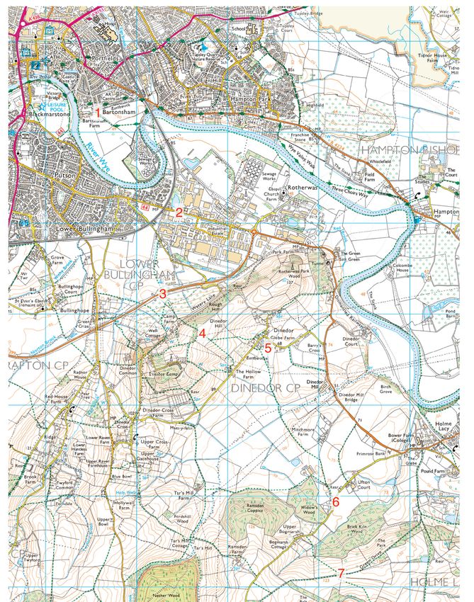
Leave the City of Hereford at the southern turn right along this road at the crossing, past
end of Green Street (point 1) via a metal the truck depot on your right. The industrial
gate beside a metal farm gate. Keep straight estate was once the site of the Rotherwas
ahead with power lines, fence and hedge Munitions Factory; for a thorough history, read
on your left to reach a gateway; go through John Edmonds’ The History of Rotherwas
this and then half left through a metal gate Munitions Factory Hereford, available from
and diagonally along a field path towards Hereford Archive and Records Centre (HARC)
the near end of the white Greenway Bridge/ and elsewhere.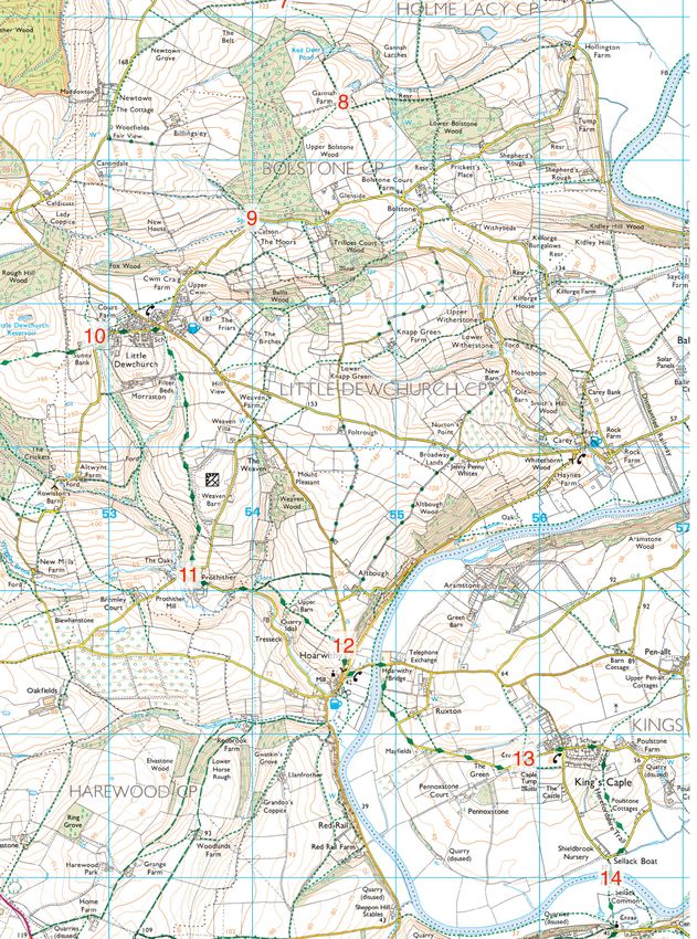
HEREFORDSHIRE WILD WALKS

               Crown copyright and database right 2020 Ordnance Survey (100024168)

Bear right at the next junction and then go         buildings. Continue over a mini-roundabout         then a metal gate and onwards, with the stream
straight to the gates onto the “Straight Mile”.     and then make a short right/left dogleg onto a     still on your right. Where the power lines pass
Continue in the same straight line on which         concrete road; where this bends 90 degrees left    overhead, turn 90 degrees left away from the
you approached the gates, doglegging right          keep straight on through a barrier with concrete   stream, then dogleg right/left over a ditch
then left to cross the “Straight Mile” safely       blocks. This track leads you onto surfaced         and continue up to a metal gate. Through this
on the pedestrian crossing (point 2). Soon          Watery Lane, on which you should turn right        gate, proceed to a wooden gate and turn right
after Gunn JCB, look left to see the classic        towards a large white house; just past this turn   down a concrete farm road, to pass under the
corrugated roofline - with “northlights” - of one   left on a signed footpath, with a stream running   Rotherwas Link Road (point 3).
of the original Rotherwas Munitions Factory         on your right. Pass through a wooden gate and      Ascend the concrete farm road to double metal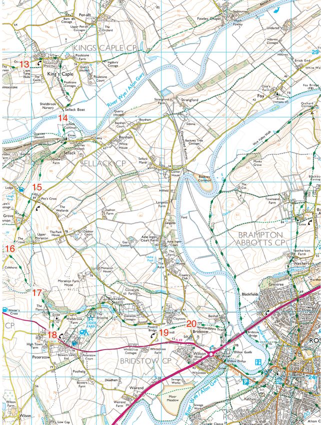
HEREFORDSHIRE WILD WALKS

farm gates in front of which you should turn        the garden boundary and turn 90 degrees               along its southwestern edge and turn left on
right, through a wooden gate and then left          right across a field edge to meet a hedge line        this to meet a surfaced lane (point 9).
after passing through a second wooden gate.         converging from your left. Keep the hedge on
After a short distance ignore the gap leading       your left after you meet it; by a wooden gate,        Turn right on the surfaced lane and walk uphill
back to the double metal farm gates and turn        cross a drive leading to a new house and barns        to the outskirts of Little Dewchurch village; the
right uphill and follow the edge of the orchard,    off to your right and keep your line through a        village has a pub. Just beyond Cwm Craig Farm
with a tall hedge on your left. At the top left     wooden farm gate into a grass lane. Follow the        and the 30 mph signs look out for gate beside
corner of the orchard climb up to a metal gate      grass lane to a metal kissing gate to emerge on       double metal farm gates and pass through this
into the next orchard and uphill along its edge,    the surfaced lane to Bogmarsh (point 6).              to a footpath. Follow the direction indicated by
with a hedge on your right. Climb up to the                                                               the fingerpost and skirt the northwest edge
interpretation board, pausing to read it, and       On reaching the surfaced lane to Bogmarsh,            of the village, heading for a gate to the left of
proceed uphill over a stile beside a metal farm     turn right past Ufton House and walk up past          double metal farm gates. Go through the gate
gate. After a short climb go straight across a      Bogmarsh Cottage on your right and look out           and carefully cross the road into the vegetation
green lane and climb the rough steps opposite       for a metal gate and fingerpost on the bank to        opposite, which may obscure the waymarks
to ascend along the edge of a wood, with views      your left; climb the bank and take this footpath.     and short path to a stile into a garden. Cross the
of the Black Mountains opening up across the        The true line of the path is the hypotenuse of a      garden to a wooden stile; once over this descend
fields on your right. At the top of the climb go    triangle but if the field is cropped, go 90 degrees   the field, approaching the left-hand boundary
over a stile and proceed ahead to the crest of      right and then 90 degrees left at the garden          and looking out for a wooden stile that you
Dinedor ridge (point 4), aiming for the distant     boundary. Descend to the valley bottom and            should cross and follow the path beyond, with a
summit of May Hill, with its distinctive clump      then ascend to the external corner of Brick Kiln      board fence on your right. Turn right down the
of trees, midway between the two closest power      Wood. Again, the true line of the footpath across     surfaced lane when you meet it and arrive at the
line poles.                                         the field is the hypotenuse of another triangle,      church (point 10). Little Dewchurch churchyard
                                                    but you may need to follow the adjacent and           is a wonderful example of “God’s Acre”; The
Cross the crest and admire the views of the         opposite sides of the triangle along the edge         Friends of St. David’s care for the churchyard
Woolhope Dome to the east, an area of Living        of the Wood, up to the stile on the ridge crest       to keep it as a place of peace and for quiet
Landscapes rich in wildlife and developed over      (point 7).                                            reflection, and as a haven for wildlife where
millennia on varied rocks of Silurian age. Across                                                         people can appreciate the beauty and diversity
the crest proceed towards the metal farm gate       Once over the stile ignore the footpaths to left      of nature: www.stdavidslittledewchurch.org.uk .
in the hedge ahead; go through this and aim         and right along the ridge and keep straight
half left to descend the footpath towards the       ahead, descending to the right of a hedge for         Continue along the surfaced lane beyond the
distant stile in the field boundary. Once over      a short distance to a stile and cross it to pass      church, round a left-hand bend and look out
the stile aim for the right hand one of a pair of   through the hedge on your left. Yet again the         for a stile and fingerpost on the left as the lane
wood-clad houses, in line with the solitary tree    true line of the footpath is the hypotenuse of a      begins to rise. Follow the fingerpost over the
in the field ahead. At the bottom of the field go   triangle and should be clear, heading off gently      stile and down to the valley bottom with a stile
through a wooden gate beside a metal farm gate      down across the sloping field; May Hill with its      to your right. Follow the attractive valley, with
and right down the lane into Dinedor village.       distinctive clump of trees should be straight         the stream on your left and power lines on
Turn right on the lane and then left through a      ahead in the distance. At the bottom of the slope     your right. Listen for the tapping of a hydraulic
gate onto the path to the church (point 5).         bear left along the top edge of a small wood and      ram on your left and look out for it working to
                                                    cross a small brow. Once over the brow, look out      pump water up from the stream, an example
Skirt to the right of the churchyard to a metal     for a bay-like shape into the woodland on your        of a sustainable power source that utilises the
farm gate with a waymarked gatepost and             right, with a waymarked stile at its head. Cross      flow of the stream. As the stream bends to its
follow as directed to a metal gate and stile        this stile into the wood and walk along the top       right, keep to its bank and pass under the power
visible beyond the corner of the churchyard.        of the dam that holds back Red Deer Pond,             lines, cross a stile and as you approach the gap
Cross this stile and follow the waymark to          which is silted up on your right. Cross a stile by    in the hedge ahead descend close to the stream
the tree at the corner of the field and follow      a metal farm gate and then bear left round the        and cross a muddy bridge over it. Continue
the same line from there to the next external       corner to another metal farm gate to the left of      along the valley bottom with the stream now
field corner and then follow the hedge on your      a large ash tree. Once through this gate, follow      on your right. Cross the bank on your left, rising
left. Cross a stile and footbridge and keep on      the grass path to Gannah Farm (point 8) via two       gradually above the stream to meet a fence
this line with the hedge still on your left to      more metal farm gates.                                coming down from your left and pass through
reach and cross a waymarked stile, footbridge                                                             a wide gateway gap in this. Carry on down the
and metal gate. Keep straight on uphill with        When you reach the gap between the barn and           valley, with the stream below on your right;
a hedge on your right, under power lines. At        farmhouse on your left, turn right over the stile     arrive at a metal farm gate and go through this
the next field boundary your route makes a          to the right of a metal farm gate; cross the field    to walk along a path to the left of a building to
small deviation from the footpath marked on         on a diagonal, aiming to pass through the trees       merge with a surfaced lane ascending from your
the OS map: do not cross the stile in the field     in the far left-hand corner. Beyond the trees,        right (point 11). Note the new symbol on the map
boundary but turn 90 degrees left towards the       cross the waymarked stile into Upper Bolstone         about 500 metres to the north of this point; this
buildings of Mitchmore Farm, signed DEFRA           Wood; look and listen for deer. Follow the path       represents Witches Solar Farm, a 6 MW, 66kv
CONSERVATION WALKS. Keep the hedge on               straight through the wood, ignoring cross tracks      solar panel array that started generating in 2013,
your right until you reach a large tree before      as directed to reach a concrete vehicle track         opposite Weaven Barn.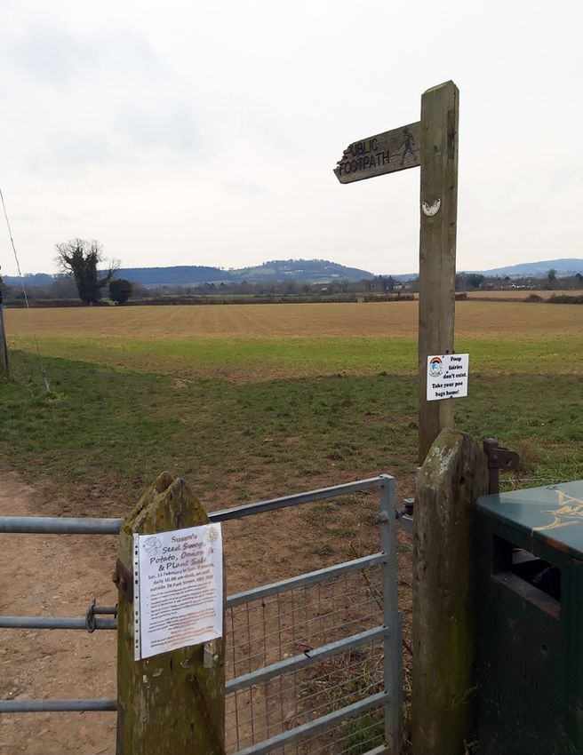
HEREFORDSHIRE WILD WALKS

                  Crown copyright and database right 2020 Ordnance Survey (100024168)

Ignore the next turn on the left and continue     for the steps on the right and climb these to a      gate and descend a short track down to meet
ahead on the lane; you have now entered the       stile onto a footpath that follows the rim of the    the Hereford to Hoarwithy road again (point 12).
Wye Valley Area of Outstanding Natural Beauty     valley with fine views. Ignore the steps and stile
and joined the Herefordshire Way and will         on your left and continue straight ahead over        Turn right downhill along the road, past
remain within the AONB – and on the Way - for     a stile to pass below Upper Barn; the tower of       Hoarwithy church on the right (well worth the
the remainder of the walk. Pass the noticeboard   Italianate Hoarwithy church comes into view.         short detour up the steps to the colonnade); the
and post box on your left and the stables on      Aim for the gateway to the left of the tower and     village also has a pub. On the road beyond the
your right and descend to walk along the lane     when you reach it go through the kissing gate to     church turn sharp left (signposted Kings Caple 1
next to the brook; take the second of two close   the left of the metal farm gate and then follow      mile) and then fork right to cross the River Wye
paths on the left – the bridleway that ascends    the hedge on the rim of the valley to another        via Hoarwithy Bridge with its former toll house
a short and impressive steep section of ancient   such gate a little further on. Further on you        on the right and take the signed footpath on the
hollow way. At the top of this section look out   should cross a stile to the left of a metal farm     right, just before the Kings Caple village sign.

4       Wildside | Spring 2021
HEREFORDSHIRE WILD WALKS
Follow this riverside path to meet a surfaced footpath on the right, also signed Seven Acres, after which you should turn right. At the 90
lane coming in from your left and continue and then fork right to arrive at and cross a stile degrees right-hand bend, turn 90 degrees left
straight ahead on this – ignoring turnings to to the left of a metal farm gate. Follow the arrow onto the footpath across Sellack suspension
Pennoxstone on the right – to pass between to the right of the ash tree ahead and then keep bridge over the River Wye (point 14) and across
Kings Caple church and the castle tump (point the field boundary on your left until you reach the meadows via a wooden footbridge and then
13). a metal kissing gate. Strike across the field on a stile to a stile to the left of a metal farm gate
the hypotenuse of a triangle to meet the hedge next to Sellack churchyard.
Stay on the tarmac and go straight across at on your right and then continue down beside it
the crossroads and continue to the far eastern before it turns away from your line to its right Pass between the church and the cottage and
edge of the village, beyond the school and the and you continue straight down the open field turn left on the track with the churchyard
entrance to Caple Avenue. Take the signed to emerge onto a surfaced lane via a metal gate, wall on your left. Soon after the wall peels left,
Crown copyright and database right 2020 Ordnance Survey (100024168)
Wildside | Spring 2021 5HEREFORDSHIRE WILD WALKS
turn right onto a signed footpath over a stile wooden gate with a steep drop into the field The valley may be one of several tributaries of
by a metal farm gate, before a black and white beyond. Descend this field to the metal gate at the Wye that carried glacial meltwater to the
cottage on the right. Ascend the field towards its foot and walk along the stream’s left bank to Wye during and after the last ice advance; the
its far end, keeping the stream on your right. Go then cross a footbridge (point 17). volumes of meltwater would have been larger
through a gate to the left of a wooden farm gate than the present flow of the Wells Brook, so the
to enter woodland beyond the dammed pond. Follow the Herefordshire Trail as a farm track little stream is a “misfit” for its relatively broad
Take the left, uphill fork of the forestry track to along the right bank of the stream to a shoot’s valley. Turn right at the grass triangle to join
emerge in a field. Cross the field to a prominent refuge container with a pond beyond it; then the Hoarwithy to Ross road and fork right at
oak tree on an external boundary corner (point ascend through a gate beside a metal farm gate the next junction to cross the Wells Brook, pass
15) and continue with a hedge initially on your and then through another metal farm gate the bus stop and take the footpath on the left,
left and then across the open field, to meet the to pass the left-hand face of a large group of through a metal kissing gate (point 19).
Ross to Hoarwithy road via a wooden gate. At buildings called The Flann. At the top of the
this point you are 200 metres up the road from drive, follow directions through the pedestrian Follow the footpath straight to Bristow church
the Lough Pool Inn. side gate and then turn left into the church car ahead, and on reaching the surfaced lane in
park, down the bank on its right into another front of the church (point 20) turn right up
Cross the road with great care and continue drive and up steps on the right, through a that lane to join the A49 by Bridstow school.
up steps and through a wooden gate onto the wooden gate and into a field, which you should Follow the pavement alongside the A49 down
footpath across the field to the stile on the cross on its diagonal, passing through another to Wilton roundabout and cross the A40 dual
opposite side, passing just right of the power gate on the way. Leave the field via a kissing carriageway on the pedestrian crossing to its
line post on the way. Follow the line of the gate and emerge next to the A49 in the village of east. Proceed towards Ross-on-Wye across
Herefordshire Trail ahead over the stile and Peterstow (point 18) which has a shop and a pub. historic Wilton Bridge and descend steps on the
between houses and gardens, past an old hand left at its far end to access the riverside walk to
pump in its enclosure and across access drives Do not cross the A49 but turn sharp left down the Hope and Anchor pub, beside which you
to merge with the surfaced lane from Pict’s surfaced Wellsbrook Lane and follow it down should climb the steps to the top of Wye Street.
Cross to Winter’s Cross. Continue straight ahead to the right bank of the Wells Brook, which Walk along narrow High Street, past the Market
down this lane to The Grove at the bottom of you should follow past Wellsbrook Barn and House (MH) at the centre of the town. If you are
the hill, with a pond on your right (point 16). the turn up to Broome Farm (where you can catching a bus back to Hereford, continue along
divert for accommodation, food and drink as Gloucester Road to the bus stops on Cantilupe
Ignore the left turn to Ross and Bridstow – and advertised). Past the turn for Broome Farm, Road.
the footpath on your right – and carry on up Wellsbrook Lane doglegs left then right over the
the lane a short distance beyond the pond and Wells Brook (ignore the track ascending ahead Further reading: The History of Rotherwas
junctions to take the footpath off the lane and from the right-hand bend). The next flat stretch Munitions Factory, Hereford, John Edmonds,
through the hedge on your left, via a wooden of the Wells Brook from the dogleg to the grass Logaston, 2004
gate. Follow the field boundary on your left, triangle is an interesting landscape, in which
through a metal kissing gate and reach a a line of pollarded willows is a key feature.You can also read