The earthquake of September 3, 1770 near Alfhausen (Lower Saxony, Germany): a real, doubtful, or fake event?
←
→
Page content transcription
If your browser does not render page correctly, please read the page content below
Historical Earthquakes, Paleoseismology,
Neotectonics and Seismic Hazard:
New Insights and Suggested Procedures
 DOI: 10.23689/fidgeo-3865

The earthquake of September 3, 1770
near Alfhausen (Lower Saxony, Germany):
a real, doubtful, or fake event?
Günter Leydecker1 & Klaus Lehmann2

1
 Isernhagen/Germany, guenter.leydecker@gmx.de
2
 Geological Survey of North Rhine-Westphalia, State Seismological Service, Krefeld/Germany, klaus.lehmann@gd.nrw.de

Abstract
In the weekly newspaper of Osnabrück (Germany) of November 3, 1770, a report about a local
earthquake was published. Pastor Buck described ground motion effects in the manor ‘Haus Horst’,
1.5 km away from the village of Alfhausen: ‘roof tiles rattled, a chimney fell down, inside the house
the top of a stove was overturned, abraded chalk trickled down in all rooms; in the nearby villages,
people felt the shaking, and especially the churches suffered noticeably’. The epicentral intensity was
estimated to VII (MSK) by Ahorner et al. (1970), but later modified to VI (EMS) by Meier &
Grünthal (1992) considering Buck’s report in detail. Since this event is the only documented
earthquake in this region, a reliable characterization of its parameters is important. Our re-examination
reveals that some reported effects are quite inconsistent. Contrary to Buck’s statement, no documents
of damages on churches or costs of repairs could be found in the parish registers. As a result, the
event appears to be a tectonic earthquake with an epicenter at Alfhausen / Haus Horst. Applying
intensity-attenuation relationships, a revised value of the epicentral intensity of ! ≤ V (EMS-98) with
a focal depth of ≥ 2 km was derived. A cavity collapse due to leaching processes as a cause of the
effects can be ruled out here. However, several details given in the primary source turned out to be
unrealistic or at least exaggerated. The tectonic earthquake on September 3, 1770 near Alfhausen
should be classified therefore as uncertain or even doubtful.

1. Introduction
Strong earthquakes with major damage to buildings are rare events in Germany. In order to estimate the
seismic hazard at a certain location, the occurrence of earthquakes in space and time as well as their
strengths must be determined. The time period of denser and systematic instrumental observations began
in the sixties of the 20th century and is far too short for this purpose. Therefore, it is essential to collect
and to evaluate any written evidence available from historical reports on earthquake effects to determine
characteristic parameters such as e.g. epicenter location, epicentral intensity, and area of perceptibility.
However, historical sources must be reviewed very critically for an identification of potential
exaggerations, false reports, pomposity, or even misinterpretation of other natural phenomena.

 36
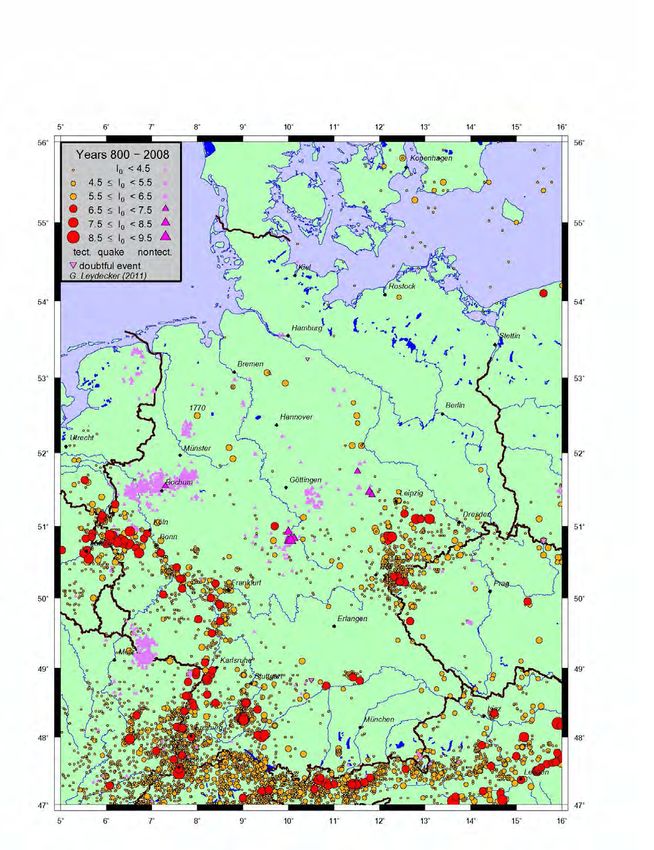
These considerations caused the re-examination of the seismic event of September 3, 1770 near
Alfhausen (district of Osnabrück, Lower Saxony, Germany). According to the current state of
knowledge, no noticeable earthquake has occurred in this region since historical times (Fig. 1).
Therefore, a reliable characterization of this event is very important. The result of this study has the
potential to significantly refine the assessment of seismic hazard in the region of western Lower Saxony
and northern North Rhine-Westphalia (north-western Germany).

 Figure 1. Map of earthquake epicenters in Germany and adjacent areas for the period AD 800 to 2008 (after
 Leydecker, 2011). The size of symbols is according to the epicentral intensity ! . The earthquake of Alfhausen
 (52° 30′ N, 7° 57′ E) is situated north of Münster and is marked with the year “1770”.

 37

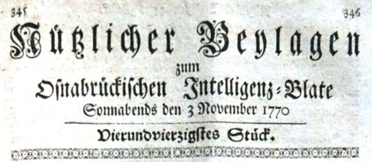
2. Previous studies
The most common report available for the earthquake of Alfhausen on September 3, 1770 was the
‘earthquake chronicle’ of August Sieberg (1940). Here, the event is described as follows (p. 95,
translation from the original in German):
 “1770, September (or November?) 3, at 11¾ h. Earthquake in the Weser Hills [Weserbergland],
 in the small district of the Bishopric of Osnabrück: In Alfhausen, from Haus Horst a chimney,
 numerous roof tiles, and plaster from the walls and ceilings of all rooms fell down. In Merzen,
 Gerde, Neunkirchen, Bramsche, and Vörden, in particular the large and massive buildings,
 especially the church buildings, had suffered noticeably.”
The original source for this description could not be revealed from Sieberg’s report, since he cites only
his own manuscript, the ‘Erdbebenkatalog der Preußischen Rheinlande, umfassend die Jahre 600-1895’
(earthquake catalogue of the Prussian Rhine Province, covering the years 600-1895), which has not been
preserved. Sponheuer (1962) classified the strength of the 1770 event on the basis of Sieberg’s
description (p. 34, translation from the original in German):
 “In the North German lowlands, [...] epicenters can be found: that of the earthquake of
 Alfhausen in 1770 with the 6th degree of strength, [...].“
Sponheuer used the macroseismic ‘Mercalli-Cancani-Sieberg-Scale’ (MCS; e.g. Sieberg, 1923, pp.
102–ff.), in which the ‘6th degree’ is characterized by the short description ‘strong’. Ahorner et al.
(1970) re-evaluated the epicentral intensity ! with a value of VII (‘damage to buildings’) according to
the updated macroseismic scale ‘Medvedev-Sponheuer-Kárník’ (MSK 1964; Sponheuer, 1965). This
value was also included in the German earthquake catalogue of Leydecker (1986).
In the course of extensive research by Meier & Grünthal (1992), a new source for the 1770 Alfhausen
seismic event was revealed. The information given here was obviously used in the description by
Sieberg. In the weekly newspaper ‘Osnabrückisches Intelligenz-Blate’ (Osnabrück Intelligence
Newspaper), published in Osnabrück, the supplement ‘Nützlicher Beylagen zum Osnabrückischen
Intelligenz-Blate’ (Useful Supplements to the ...) appeared on November 3, 1770 (Fig. 2) with an article,
which was written by Pastor J.H. Buck (1770) from Neuenkirchen (approx. 6 km away from Alfhausen):
 “Notice of the remarkable earthquake in the northern region of the Bishopric of Osnabrück on
 Sept. 3rd, 1770”.

Figure 2. Title page of the newspaper supplement ‘Nützlicher Beylagen zum Osnabrückischen Intelligenz-Blate’
 (Useful Supplements to the Osnabrück Intelligence Newspaper), issue of November 3, 1770.

The full name of the author was identified with Pastor Johann Heinrich Buck (U. Braumann,
Freiburg i.Br., pers. comm.). This text is reproduced, transliterated, and translated in the appendix.

 38
Based on this report, Meier & Grünthal (1992) re-evaluated the seismic effects of this events with the
epicentral intensity of VI (‘light building damage’) according to the scale EMS-92, a previous version
of the actual ‘European Macroseismic Scale 1998’ (EMS-98, 1998). This intensity value was
consecutively adopted in the updated earthquake catalogues of Leydecker (1997, 2011).
However, a detailed re-examination of all information available on the 1770 Alfhausen event raised
fundamental questions. The aim of this study was therefore to check whether the earthquake – as it is
currently interpreted – can be reliably verified, or whether the event has to be classified as doubtful or
uncertain. Principally, a cause other than a tectonic earthquake must also be considered: the effects of a
sinkhole in this region cannot be excluded a priori. All available information were used for a source-
critical re-evaluation of the 1770 Alfhausen event.

3. Further research on available sources
New research showed that the report in the ‘Osnabrückisches Intelligenz-Blate’ was also taken over by
the newspaper ‘Staats-Relation derer neuesten Europäischen Nachrichten und Begebenheiten’ (State
Relation (newspaper) of the newest European news and occurrences) from the city of Regensburg
(Bavaria, Germany) in its issue of November 30, 1770 (Fig. 3, translated):
 “The earth tremors, which have recently frightened everyone in the Vogtland region and the
 surroundings, have also been noticed, according to a report from Osnabrück, on the 3rd of this
 [month, i.e. November] soon after 11 o’clock at noon in the villages of Merzen, Alfhausen,
 Gerde, Neuenkirchen, Bramsche, and Vörden, by 2 immediately successive shocks. The latter,
 which lasted about half a minute, happened with such a violent and trembling movement that
 the tiles on the roofs made a very terrible rattling. All cupboards, chairs, tables, etc. threatened
 to overthrow. But most of the large and massive buildings, especially the church vaults in the
 above-mentioned places, had suffered.”

 Figure 3. Article on the 1770 Alfhausen earthquake in the Regensburg newspaper ‘Staats-Relation’, issue of
 November 30, 1770.

It is obvious that the text literally adopts individual formulations of the Osnabrück article. The
descriptions of the Alfhausen event, however, are interpreted here as an effect of the earthquake series

 39
in the Vogtland region (Saxony, Germany) which lasted from September to November 1770 (cf. Rabe,
1771, p. 61; Sieberg, 1940, p. 95). Because of these formulations, Sieberg’s doubt about the month in
which the event occurred (“September (or November?)”) appears to be understandable.
The ‘Augspurgische Extra-Zeitung’ (Extra Newspaper Augsburg) contains a further report in its issue
of December 11, 1770 and copies entire passages from the Osnabrück article (a facsimile of this article
is printed in Leydecker & Lehmann, 2019a). Here again the 3rd of September is mentioned as the day
of the event. However, the late publication date and the mistake with the spelling of the village names
(“[...] Mergen, Ahlhausen, [...]” instead of Merzen, Alfhausen) clearly identify the article as an
adaptation.
The message was also taken up in the ‘Meteorologische Beobachtungen’ (Meteorological Observations)
for November 1770 by Johann Georg Rabe (1771), but instead of the third day of the month the fifth is
mentioned here, probably due to a transcription mistake. Here, the earthquake is described as a local
event (p. 61, translation from the original in German):
 “In the Osnabrück region, on the 5th of this [month, i.e. November] noon, 1 quarter past
 11 o’clock, in Merzen, Alfhäusen, Gerde, etc., two successive earth tremors were felt; the last
 of them was so violent that cupboards, tables, and chairs in the homes threatened to be
 overturned, and even the church vaults in the named villages had suffered noticeably.”
In the latter publication – as well as in Bucks’s report and in the compilation of the Augsburg
newspaper – the event time is formulated with the term “ein Viertel auf Zwölfe in der
Mittagsstunde” (translated literally: “a quarter ‘on’ twelve at noon”). Uwe Braumann explained, that
people at that time understood with this description: “a quarter past eleven at noon”, or 11:15 (pers.
comm.). Therefore, the time “soon after 11 o’clock at noon” in the newspaper ‘Staats-Relation’
of Regensburg is consistent with the original description. In contrast, since Sieberg (1940), the
event time has been fixed with 11:45 in German earthquake catalogues.
From the early 20th century, an additional brief mention of the event was found in the 1911 report of
the ‘Naturwissenschaftlicher Verein zu Osnabrück’ (Osnabrück Society for Natural Sciences). Again,
the earthquake of 1770 is regarded as an effect of a distant earthquake (translation from the original in
German):
 “Mr. Freund, railway secretary, reports on earthquakes observed according to the
 Osnabrückische Anzeigen [Osnabrück Newspaper] in earlier times in our region, so [...] on a
 heavy one on September 3, 1770 in the area of Merzen, Alfhausen, Gehrde, Neuenkirchen,
 Bramsche. [...] In all cases it is probably a matter of effects from catastrophes that had their
 epicenter elsewhere. There have been no serious accidents in our area.”
Although the date and time has been confused several times, all these sources are probably directly or
indirectly based on Buck’s article. However, additional details of the seismic effects cannot be derived.
The report in the newspaper ‘Osnabrückisches Intelligenz-Blate’ is thus the only known primary source
for the 1770 Alfhausen event.
An evaluation of the principal reliability of articles published in the supplement ‘Nützlicher Beylagen
zum Osnabrückischen Intelligenz-Blate’ could not be carried out within this study. But it is clear, that
the article on the 1770 event has the character of a letter to the editor. There is no indication that the
contribution was revised or even proven by the editorial office of the newspaper ‘Osnabrückisches
Intelligenz-Blate’.
Further research showed that there is no report about earthquakes to be found in the available church
registers of the villages in the vicinity of Alfhausen. There is also no mention of an earthquake in a list
of important events which was included in the parish register of the nearby village of Gehrde
(U. Braumann, Freiburg i.Br., pers. comm.). As a result, our knowledge of the 1770 Alfhausen event is
based exclusively on the individual report of Pastor Buck.

 40
4. Earthquake effects and geological conditions
The details of the damage and the perceptibility are analyzed intensely and discussed critically. The
geological conditions are also considered in order to identify potential site effects. This information
forms the basis for our re-evaluation of the earthquake report.
Pastor Buck mentions in his article “Merzen, Alfhausen, Gerde, Neuenkirchen, Bramsche, and Vörden”
as places where the earthquake was felt. In addition, he describes the seismic effects at the “noble Haus
Horst near Alfhausen” in detail. ‘Haus Horst’ is a detached manor, about 1.9 km northeast of the village
of Alfhausen (Fig. 4). All other places mentioned are located within a radius of approx. 10 km around
Haus Horst (Fig. 5) in the district of Osnabrück (Lower Saxony, Germany).

 Figure 4. Topographic map (detail) of the surroundings of ‘Haus Horst’ (H. Horst) (von LeCoq, 1805).

4.1. Earthquake damage and effects at Haus Horst
For the manor Haus Horst, the following observations and damage are mentioned as being caused by an
earthquake:
- A chimney fell from the roof.
- Inside the house, in a large hall, the top of the oven was overturned.
- At the cross-beams of all rooms, lime is rubbed off the ceiling.
Reports on the management and administration of Haus Horst for the years 1754–1917 are preserved in
the so-called ‘Lager Buch’ (stock-book). They describe the relevant events concerning the manor in
detail, also for the period around 1770. At that time the property was managed by an estate administrator,
who was obliged – in his own interest – to inform the owner about all incidents. However, the ‘Lager
Buch’ does not contain any references to the earthquake nor to damage or possible repair costs (Meier &
Grünthal, 1992, pp. 72 f.). Therefore, it can be deduced that, either damage could be repaired at low cost
and was not worth mentioning, or the extent of damage was strongly exaggerated by Buck.

 41
Figure 5. Locations where the earthquake of 1770 was perceived (names of villages in bold letters) according to
 the report of Pastor J.H. Buck.

Pastor Buck summarizes the damage in the surrounding villages with the description that “[...] especially
large and heavy buildings, in particular the vaults of the churches at most of the abovementioned
villages, had suffered noticeably”. It remains unclear, which effects are specifically meant by the term
“suffered noticeably”: it would generally appear to designate clearly visible damage. In this case, it is
surprising that Pastor Buck describes meticulously the damage in Haus Horst but does not mention at
all any damage at his own church in Neuenkirchen (about 6 km east of Haus Horst). Additionally,
there is no further evidence of serious damage to the church buildings mentioned in other sources.
The extensive investigations by Meier & Grünthal (1992) have also shown that neither the holdings of
the Regional Archive of the Protestant Church nor those of the Diocesan Archive of Osnabrück contain
any evidence of the earthquake, of damage, or of the respective repair. Mr. zu Hoene, who has worked
up the history of Alfhausen (zu Hoene, 1977), carried out further investigations, but did not discover
any indication of damage in the church registers. Also, the preserved bills of the catholic parish church
St. Johannis in Alfhausen show no expenses for repair works in the respective time period (Meier &
Grünthal, 1992, p. 74).
Despite intensive research in the surroundings of Haus Horst, further damage caused by the earthquake
could not be substantiated. According to the available information, the description of the overturned
chimney and of the lime abrasion on the cross-beams in all rooms of Haus Horst remains singular.
According to the macroseismic scale EMS-98, this condition does not really permit an intensity
assessment.
In addition, it should be noted that the structural condition of the farm house at that time may have
favored the extent of the reported damage. Since the contemporary building had been pulled down and
was subsequently replaced in 1885 (Steinwachs et al., 1996), further evidence of the damage does not
exist anymore.

 42
4.2. Perceptibility of the event and effects in the environment
The area affected by the earthquake of 1770 is described as “[...] the area from west to east, doubtless
3 miles in length and 2 in width, namely the villages of Merzen, Alfhausen, Gerde, Neuenkirchen,
Bramsche and Vörden [...]”. Applying the ‘Prussian mile’ or a related measure with a value of 7.5 km,
this description corresponds to an area of about 20 km by 15 km. According to the statement of Pastor
Buck, the earthquake was explicitly not noticeable in the ‘Artland’ (“Orth- or Arthland”), i.e. in the area
of the landscape about north of the villages of Ankum and Bersenbrück (see Fig. 5).
The following facts support this assumption:
(1) The earthquake happened on September 3, 1770. The report was written by Pastor Buck on October
 9 and published in a supplement to the weekly newspaper ‘Osnabrückisches Intelligenz-Blate’ on
 November 3. This is not in accordance with a far-reaching and heavily perceptible event that had to
 be immediately reported.
(2) In the introduction to the article, the author mentions that some persons were surprised that the
 earthquake had not been reported in the public newspaper so far. Even if the event was felt only
 weakly (intensity III) in Osnabrück (in a distance of some 25 km), this remark would certainly not
 have been necessary. In this case, at least a supplementary description of Buck’s report or a hint
 about what happened in Osnabrück could have been expected.
It is reported in Buck’s description that the church vaults in most of the above-mentioned villages
“suffered noticeably”.
Additionally, it is stated that the roof tiles rattled “throughout” and furniture in the houses were heavily
shaken. All the inhabitants (“everyone”) were frightened and flew from their houses. It is not clear,
whether the author relates these effects and the people’s reaction to the entire area which he describes
to be affected.

4.3. Geological conditions
In the Alfhausen region, the geological unit ‘Münder marl’ (Upper Jurassic) gets in contact with the
groundwater. Leaching processes of these ground layers have already led to subrosion and the
occurrence of sinkholes in the northern foreland of the Wiehen mountains (‘Wiehengebirge’, cf. Tüxen,
1986). Such events were documented since the 16th century (e.g. Grahle & Schneekloth, 1963).
However, there is no evidence that these events were accompanied by any noticeable shaking.
In the area of Alfhausen, the documented sinkholes have only a very small extent. In the section ‘3514
Vörden’ of the Geological Map 1 : 25 000 (GK 25, Mengeling 1986), 21 small-scale sinkholes were
documented. The most recent one has been recorded in 1985 (status of 1995, pers. comm.
K.-H. Büchner, Hannover). However, there is no (geological) evidence for local sinkholes at Haus
Horst, nor in the reports of the above-mentioned ‘stock-book’. The Geological Map (GK 25, Landesamt
für Bergbau, Energie und Geologie, 2018) describes the near-surface ground of Haus Horst as fluviatile
deposited middle sand (Weichsel glacial). The soil conditions immediately to the west and east of Haus
Horst were investigated with two sounding boreholes. According to Steinwachs et al. (1996, p. 3) “[…]
relatively stable meltwater sands lie here at a depth of about 8 m and deeper”. Additionally, the
foundations of Haus Horst support the existence of a weak ground: “According to the owner, the current
building was founded on oak piles [...]” (Steinwachs et al., 1996), built in the second half of the 19th
century.
A Holocene peat area (‘Ueffelner Aue’) extending in north-south direction is situated directly east of
Haus Horst. This area is about 250 m wide and ends about 200 m northeast of the manor. A peat
thickness of up to 2 m is known in this area, and a postglacial subsidence area due to leaching processes
can be supposed there.
The underlying layer of the Saliniferous Formation is assumed to be found at a depth of about 2 km.
Tectonic earthquakes can therefore principally only occur below this depth. There is no indication of
seismically active faults in this area.

 43
5. Macroseismic evaluation
In all previous investigations, the epicentral intensity was derived solely from the seismic effects
mentioned for Haus Horst. Form and extent of isoseismals or assumptions about the focal depth had not
been considered. In contrast to the studies published so far, we think that the descriptions for Haus Horst
are not reliable and thus not suitable for the determination of the epicentral intensity. Therefore, we try
to combine all reported aspects for a plausible intensity assessment.
The intensity distribution of an earthquake principally depends on the epicentral intensity ! and on the
focal depth . Figure 6 shows the intensity-attenuation relationship for different values of using two
common models, derived for the area of Germany (Sponheuer, 1958) and for northwest Europe
(Ambraseys, 1985), respectively. These relations are based on intensity values according to the
macroseismic scale MSK 1964, but can also be applied in a first approximation to the actual scale
EMS-98.

 Figure 6. Intensity-attenuation relationship for different focal depths z after Sponheuer (1958, ‘S’, =
0.002 km"# ) and Ambraseys (1985, ‘A’). ! is the epicentral intensity and the intensity at a certain place in the
distance from the epicenter. Several distances are marked, for the villages, which were mentioned in the report
 by Pastor Buck, and for the city of Osnabrück.

Because Alfhausen, respectively Haus Horst, is located in the center of the affected area, it can be
plausibly associated with the epicentral area. However, it is noticeable that neither for the village of
Bersenbrück nor for Ankum, situated inside the assumed affected area, perceptibility is reported
(cf. Fig. 5).

 44
The intensity-attenuation relationships do not permit any combination of epicentral intensity and focal
depth which meet the following conditions: (1) damage to the vaults of the churches in the surroundings
of Alfhausen (i.e. ≈ V–VI), a large number of inhabitants escaping from their houses (i.e. = VI) at
an epicentral distance of 10 km and – at the same time – (2) no perceptibility in only slightly larger
distances (Artland: more than 10 km, Osnabrück: about 25 km). This leads to the conclusion that the
description of the church vaults having “suffered noticeably” cannot be synonymous with the occurrence
of damage and has to be classified to be by far exaggerated. Nor the description of the inhabitants’
reaction can be reliable, neither for the epicentral area nor for the entire affected region.
If we assume instead that the earthquake was at least clearly felt in the villages at an epicentral distance
of 10 km ( "! ≥ III), the difference between the intensities at a distance of 10 km and 25 km (Osnabrück:
 #$ < II), amounts to "! − #$ > 1. Figure 6 shows that these conditions can only be met for focal
depths of less than about 5 km. For focal depths of 2 and 5 km, the epicentral intensity ! reaches
maximum values of V or IV, respectively. An epicentral intensity of VI, as derived by Meier & Grünthal
(1992) (and also later confirmed by L. Ahorner, pers. comm., 1995) cannot be reproduced within this
model. The earthquake would still have been felt with intensity III in Osnabrück assuming a very
shallow focal depth (2 km), or even with an intensity IV assuming a depth of 5 km. It was already shown
that this case is not plausible.
Seismic effects caused by relatively small sinkholes are in principle possible, but would only be felt in
the immediate vicinity. An affected area comprising the seven villages mentioned by Buck cannot be
explained by such an event. Theoretically, larger sinkholes due to subrosion processes may explain the
described ground motions. However, since there is no documented sinkhole in this area that had been
associated with noticeable seismic effects, this explanation seems to be very unlikely.
As a working hypothesis, an earthquake near Alfhausen seems to be the only possible explanation as the
cause of the reported effects. In this case, the epicentral intensity must be estimated with ! ≤ V at an
assumed focal depth of ≥ 2 km. Only under these conditions an affected area with a radius of about
10 km and simultaneously rattling of the glasses and a trembling of the furniture ( = IV) in at least the
nearby village of Alfhausen can be assumed to be plausible. The fallen chimney at Haus Horst cannot
be used for intensity evaluation because the structural condition of the estate is unknown.
With the solution described here, Pastor Buck’s report can possibly be explained in its basic elements.
In contrast, the effects mentioned for the surroundings of Haus Horst and the description of the effects
in the affected area appear to be grossly exaggerated. Thus, the remark of the local historian Mr. zu
Hoene is probably pretty close to the truth: “Pastor J.H. Buck’s (Neuenkirchen) report seems to be
somewhat sensational after all.” (Meier & Grünthal, 1992, p. 74). Additional sources which enables us
to decide whether Pastor Buck’s report can be rated to be basically trustworthy, are not known so far.
It must be noted, that the source material is quite sparse, and the solution presented here is based on
many assumptions. Therefore, we recommend the earthquake of 1770 near Alfhausen to be classified as
‘uncertain’, or even as ‘doubtful’.

6. Conclusions
In this study, the information available on the earthquake of Alfhausen (Lower Saxony, Germany) of
September 3, 1770 was examined in detail, and the literary source was critically discussed. The intensity
of this event could be re-evaluated with regard to the documented seismic effects. The local ground
conditions were also included in the interpretation. With the use of intensity-attenuation relationships,
the extent of the affected area could only be explained if a shallow focal depth is assumed and the
epicentral intensity has a lower value than in previous studies. Essential elements of the primary report
by Pastor Buck can be confirmed in principle, but only on condition that all descriptions are rated to be
grossly exaggerated.

 45
A tectonic earthquake can be assumed on September 3, 1770 at 11:15 local time with an epicenter in the
vicinity of Alfhausen. The parameters of this event are listed in Table 1 (see Leydecker & Lehmann,
2019b).
The possibility of the effects being caused by a collapse of a ground cavity seems to be extremely
unlikely. Since all evaluations carried out are based on only one primary source, which does not seem
to be reliable in significant points, we recommend the occurrence of a tectonic earthquake on
September 3, 1770 near Alfhausen to be regarded as uncertain, or even doubtful.

 Table 1. Parameters of the earthquake of September 3, 1770.
 Date September 3, 1770
 Time 11:15 (local time)
 Epicenter Alfhausen / Haus Horst
 Coordinates 52° 30′ N, 7° 57′ E
 Focal depth z ≥ 2 km
 Maximum intensity I0 ≤ V (EMS-98)
 Radius of perceptibility RS ≈ 10 km
 Remark Uncertain or doubtful event

Acknowledgements
We thank Florian Leydecker for taking the photographs from the 1770 newspaper, Holger Busche for
his help with compiling the epicenter map, and Sebastian Busch for his valuable comments on the
manuscript. Furthermore, we thank Klaus-Peter Bonjer for his critical review and his detailed and
helpful comments. Uwe Braumann, historian, contributed with a careful historical review. We are very
grateful for his expertise which enabled a more comprehensive discussion of the Alfhausen event.

References
Ahorner, L., Murawski, H. & Schneider, G. (1970): Die Verbreitung von schadenverursachenden
 Erdbeben auf dem Gebiet der Bundesrepublik Deutschland. Zeitschrift für Geophysik, 36, 313-343.
Ambraseys, N. (1985): Intensity attenuation and magnitude-intensity relationship for Northwest
 European earthquakes. Earthquake Engineering and Structural Dynamics, 13, 733-778.
Augspurgische Extra-Zeitung von Staats-politischen und anderen Neuigkeiten (1770). Anno 1770
 (Num. 296, 11. Dec.). Augspurg (Augsburg).
Buck, J.H. (1770): Nachricht von dem merkwürdigen Erdbeben im Nordlande im Fürstentum Osnabrück
 den 3. Sept. 1770. Nützlicher Beylagen zum Osnabrückischen Intelligenz-Blate, 1770
 (Vierundvierzigstes Stück, 3 November), c. 349-352. Osnabrück.
Grahle, H.-O. & Schneekloth, H. (1963): Der Darnsee bei Bramsche (geologische Untersuchungen
 an niedersächsischen Binnengewässern II). Geologisches Jahrbuch, 82, 43-64. Hannover.
EMS-98 (1998): European Macroseismic Scale 1998. Grünthal, G. (ed.), Musson, R.M.W.,
 Schwarz, J. & Stucchi, M. (assoc. eds.). European Seismological Commission. Cahiers du Centre
 Européen de Géodynamique et de Séismologie, 15, 99 p. Luxembourg, Conseil de l’Europe.
zu Hoene, O. (1977): Denkwürdigkeiten. In: zu Hoene, O. & Meyer, R. (eds.). 1000 Jahre Alfhausen
 977–1977. Beiträge zur geschichtlichen Entwicklung des Kirchspiels. 69-71. Alfhausen.
Landesamt für Bergbau, Energie und Geologie (2018): NIBIS-Kartenserver: Geologische Karte
 1 : 25 000. www.lbeg.niedersachsen.de/kartenserver. Hannover.

 46
von LeCoq, K.L. (ed., 1805): Karte Gegend von Osnabrück und von Dümmer-See, so wie eines Theils
 von Oldenburg und Hannover. Section IX. Hannover, Niedersächsisches Landesverwaltungsamt –
 Landesvermessung.
Leydecker, G. (1986): Erdbebenkatalog für die Bundesrepublik Deutschland mit Randgebieten für die
 Jahre 1000–1981. Geologisches Jahrbuch, E 36, 3-83. Hannover.
Leydecker, G. (1997): Erdbebenkatalog für die Bundesrepublik Deutschland mit Randgebieten für die
 Jahre 800–1993 (Schadenbeben bis 1996). Extended data file. Hannover, Bundesanstalt für
 Geowissenschaften und Rohstoffe.
Leydecker, G. (2011): Erdbebenkatalog für Deutschland mit Randgebieten für die Jahre 800 bis 2008
 (Earthquake catalogue for Germany and adjacent areas for the years 800 to 2008). Geologisches
 Jahrbuch, E 59, 1-198. Hannover. cf. www.bgr.de/quakecat_en.
Leydecker, G. & Lehmann, K. (2019a): Das Erdbeben vom 3. September 1770 bei Alfhausen
 (Niedersachsen): real, zweifelhaft oder erfunden? Mitteilungen der Deutschen Geophysikalischen
 Gesellschaft, 1/2019, 10-17.
Leydecker, G. & Lehmann, K. (2019b): Erratum zu Leydecker & Lehmann, DGG-Mitteilungen, Heft
 1/2019. Mitteilungen der Deutschen Geophysikalischen Gesellschaft, 2/2019, 26.
Meier, R. & Grünthal, G. (1992): Eine Neubewertung des Erdbebens vom 3. September 1770 bei
 Alfhausen (Niedersachsen). Osnabrücker Naturwissenschaftliche Mitteilungen, 18, 67-80.
 Osnabrück.
Mengeling, H. (1986): Geologische Karte von Niedersachsen 1 : 25 000. Section 3514 Vörden. 7 maps,
 explanation, 125 p. Hannover, Niedersächsisches Landesamt für Bodenforschung.
Naturwissenschaftlicher Verein zu Osnabrück (ed., 1911): Tätigkeit des Vereins. 1907. Siebzehnter
 Jahresbericht. Für die Jahre 1907, 1908, 1909, 1910, I-XVIII. Osnabrück, Meinderssche
 Buchhandlung.
Rabe, J.G. (1771): Meteorologische Beobachtungen vor das Jahr 1770. Worinnen sowohl die
 Barometer- als Thermometerhöhen, ingleichen die Wind- und Wetterveränderungen, nebst der
 Höhe des gefallenen Regenwassers, täglich zu drey verschiedenen mahlen aufgezeichnet worden.
 64 p. Anspach, Poschische Hofbuchhandlung.
Sieberg, A. (1923): Geologische, physikalische und angewandte Erdbebenkunde. 572 p. Jena, Gustav
 Fischer.
Sieberg, A. (1940): Beiträge zum Erdbebenkatalog Deutschlands und angrenzender Gebiete für die
 Jahre 58 bis 1799. Mitteilungen des Deutschen Reichserdbebendienstes, 2, 1-111. Berlin.
Sponheuer, W. (1958): Die Tiefen der Erdbebenherde in Deutschland aufgrund makroseismischer
 Berechnungen. Annali di Geofisica, XI (3-4), 157-167. Roma.
Sponheuer, W. (1962): Untersuchung zur Seismizität von Deutschland. In: Sponheuer, W. (ed.). Zum
 Gedenken Emil Wiecherts anläßlich der 100. Wiederkehr seines Geburtstages. Veröffentlichungen
 des Instituts für Bodendynamik und Erdbebenforschung in Jena, 72, 23-52. Berlin.
Sponheuer, W. (1965): Bericht über die Weiterentwicklung der seismischen Skala. Veröffentlichungen
 des Instituts für Geodynamik Jena, 8, 1-21. Berlin.
Staats-Relation derer neuesten Europäischen Nachrichten und Begebenheiten (1770). 1770 (CXLIII.
 Stück, 30. November). Regensburg, Joh. Christoph Reindl.
Steinwachs, M., Hinze, C. & Mengeling, H. (1996): Erkundung des Untergrundes im Bereich des
 Erdbebens von Alfhausen bei Osnabrück im Jahre 1770. – Report 114846, 11 p. (Aug. 5, 1996).
 Hannover, Niedersächsisches Landesamt für Bodenforschung.
Tüxen, J. (1986): Erdfälle und Subrosionssenken. In: Mengeling, H. (1986). Geologische Karte von
 Niedersachsen 1 : 25000, Erläuterungen zu Blatt Nr. 3514 Vörden. 93-99. Hannover,
 Niedersächsisches Landesamt für Bodenforschung.

 47
Appendix
A. Facsimile of the article of Pastor J.H. Buck (1770)
All issues of the weekly newspaper ‘Osnabrückisches Intelligenz-Blate’ (Osnabrück Intelligence
Newspaper) with the respective supplements ‘Nützlicher Beylagen zum Osnabrückischen Intelligenz-
Blate’ (Useful Supplements of the ...) of the year 1770 are collected in the central municipal library
(Stadtbibliothek-Zentralbibliothek) of Hannover/Germany, bound in the volume ‘ZsH 301 1770’. The
pages of the newspaper have a size of ca. 20.5 cm in height and 16.5 cm in width, printed on both sides,
and organized in two columns, serially numbered beginning with the first issue of January. The
described earthquake report can be found in the columns 349 to 352 (Figs. A1, A2).

 48
Figure A.1. First part of the article about the 1770 earthquake by J.H. Buck in the newspaper supplement
 ‘Nützlicher Beylagen zum Osnabrückischen Intelligenz-Blate’, issue of November 3, 1770, c. 349-350.

 49
Figure A.2. Second part of the article about the 1770 earthquake by J.H. Buck in the newspaper supplement
 ‘Nützlicher Beylagen zum Osnabrückischen Intelligenz-Blate’, issue of November 3, 1770, c. 351-352.

 50
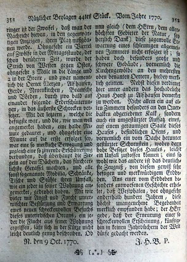
B. Transliteration of the article of Pastor J.H. Buck (1770)
 Nachricht von dem merkwürdigen Erdbeben im Nordlande* im Hochstift Osnabrück den
 3 Sept. 1770.
 Verschiedene selbst einsichtsvolle Patrioten, haben gelegentlich keine geringe Befremdung
 darüber geäußert, daß man von dem gewiß sehr fürchterlichen und schreckenvollen Erdbeben,
 welches das Nordland im Hochstift Osnabrück den 3 September d. J. betroffen, in öffentlichen
 Blättern, die öffentliche Anzeige vermisset hat. Um desto geringer ist der Zweifel, daß man der
 Nachricht hievon, in den gegenwärtigen Anzeigen, ihren Platz mißgönnen werde. Ohngefehr
 ein Viertel auf Zwölfe in der Mittagsstunde, der schon berührten Zeit, wurde der Strich von
 Westen gegen Osten, ohngefehr 3 Meile in die Länge und 2 in der Breite, und zwar namentlich
 die Oerter Merzen, Alfhausen, Gerde, Neuenkirchen, Bramsche und Vörden, durch zwo bald
 auf einander folgende Erderschütterungen, in das äußerste Schrecken versetzet. Mit der
 letztern, welche die heftigste war, und die, wie man will angemerket haben, eine halbe Minute
 gedauret, und ohngefehr eine Minute auf die erste erfolget sey, war eine so merkliche Bewegung
 und zugleich eine so zitternde Erschütterung verbunden, daß überhaupt die Ziegeln auf den
 Dächern, das fürchterlichste Gerassel machten, und alle sonst sogenannte Mobilia, Schränke,
 Tische und Stühle ihren Umfall, wie ein jeder in seiner Wohnung angemerket, gedrohet haben.
 Mit wie vieler mit Angst und Furcht untermischter Bestürzung und Erwartung eines neuen
 schreckenvollen Besuchs dieses unterirdischen Orcans, ein jeder die Flucht aus seiner
 Wohnung ergriffen, läßt sich in der Kürze nicht leicht deutlich genug beschreiben. Ob nun
 gleich (dem HErrn, dem allerhöchsten Gebieter der Natur, sey herzlich Dank) diese zagenvolle
 Erwartung eines schleunigen allgemeinen Jammers nicht erfolget ist; so haben doch besonders
 große und schwere Gebäude, vornemlich die Kirchengewölbe an den mehresten oben benanten
 Oertern, hiebey merklich gelitten. Nebst diesen verdienet hier unter andern das hochadeliche
 Haus Horst zu Alfhausen bemerket zu werden. Nicht allein ein auf allen Zimmern besonders an
 den Querbalken abgeriebener Kalk, sondern auch ein umgestürzter Aufsatz eines, auf einem
 geraumigen Saale dieses Hauses, befindlichen Ofens, und vornemlich ein vom Dache herunter
 gestürzter Schornstein, wobey dern hohe Besitzer dieses Hauses, leicht ein Unfall zustossen
 können; eins so wohl wie das andere ist das deutlichste Zeugniß, von diesem gewiß sehr heftigen
 und merkwürdigem Erdbeben. Aus einer vom Erdbeben besonders entworfenen Geschichte
 erhellet, daß Westphalen, vor ohngefehr anderthalb hundert Jahren, diese höchst unangenehme
 Begebenheit merklich empfunden habe; der HErr gebe, daß der Erneurung einer so
 schreckenvollen Erscheinung, künftighin in keinen Jahrbüchern der Welt dürfe gedacht werden.
 N. den 9 Oct. 1770. J.H.B. P.

 * Von einem hohen verehrungswürdigen Gönner bin belehret, daß der Norderwinkel des
 Hochstifts Osnabrück in alten Documenten in das Nordland und Orth- oder Arthland, wie es
 auch so oft ausgedruckt wird, eingetheilet sey. Zu den letztern zählet man die äußersten
 Gegenden dieses Hochstifts an dieser Seite, und zu dem ersten die nächst angrenzende Seite und
 Oerter gegen Südosten; in jenem Striche hat man auch von dem jetzt beschriebenen Erdbeben
 keine Empfindung gehabt. B.

 51
C. Translation (attempt) of the article of Pastor J.H. Buck (1770)

 Notice of the remarkable earthquake in the Nordland* of the Bishopric of Osnabrück on
 Sept. 3, 1770
 Various reasonable patriots have occasionally expressed their utter astonishment at the fact
 that any public report has been missed in public newspapers of the really very terrible and
 frightening earthquake which affected the Nordland of the Bishopric of Osnabrück on
 September 3, this year. The less is the doubt that one will grudge the news a place in the actual
 newspapers. A quarter past eleven at noon, on the already mentioned date, the area from west
 to east, roughly 3 miles in length and 2 in width, namely the villages of Merzen, Alfhausen,
 Gerde, Neuenkirchen, Bramsche and Vörden, was heavily frightened by two earth tremors soon
 following each other. The latter, which was the most violent, and, as one believed to have noted,
 lasted half a minute, and which happened approximately a minute after the first, was
 accompanied by such a noticeable movement and, at the same time, such a trembling shock that
 the tiles on the roofs rattled in the most terrible way, and in addition all the so-called Mobilia,
 cupboards, tables, and chairs threatened to fall down, as everyone noted in his home. With how
 much fear and anxiety, mixed with dismay and expectation, of a new frightful visit to this
 underground storm everyone was fleeing from his home, cannot easily be described clearly
 enough in the brevity. Whether this timid expectation of a sudden general misery has not been
 met (to the Lord, the supreme lord of nature, be cordially thanked); yet especially large and
 massive buildings, in particular the vaults of the churches at most the above-mentioned villages,
 had suffered noticeably. Additionally, among others the noble Haus Horst near Alfhausen
 deserves to be noticed. Not only a lime rubbed off in all the rooms, especially on the cross-
 beams, but also an overturned top of a stove in a spacious hall of this house, and especially a
 chimney fallen down from the roof, which could have easily caused an accident to the noble
 owner of this house; the one as well as the other is the clearest testimony of this certainly very
 violent and remarkable earthquake. From a story especially dealing with the earthquake it
 becomes clear that Westphalia, one and a half hundred years ago, had noticeably felt this most
 unpleasant incident; the Lord may give that in the future, no renewal of such a frightful
 phenomenon may occur which has to be remembered in any yearbooks of the world.
 N., Oct. 9, 1770. J.H.B. P.

 * I was informed by a noble venerated patron that in old documents the Norderwinkel of the
 Bishopric of Osnabrück is divided into the Nordland and the Orth- or Arthland, as it is often
 called. The outermost regions of this bishopric on this side belong to the latter one, and the next
 adjoining side and villages towards southeast belong to the first; in that area one had no
 perception of the earthquake described here. B.

 52
Editor Dr. rer. nat. Diethelm Kaiser Bundesanstalt für Geowissenschaften und Rohstoffe, Hannover, Germany Publisher Deutsche Gesellschaft für Erdbebeningenieurwesen und Baudynamik (DGEB) e.V. Prof. Dr.-Ing. habil. Frank Wuttke c/o Christian-Albrechts-Universität zu Kiel Lehrstuhl für Geomechanik und Geotechnik Ludewig-Meyn-Strasse 10 24118 Kiel © 2020 Das Copyright der Beiträge liegt bei den jeweiligen Autoren. Alle Rechte, insbesondere das der Übersetzung in fremde Sprachen, vorbehalten. Umschlaggestaltung: Lena Haubner Lektorat, Korrektorat: Diethelm Kaiser Cover image: Historical representation of e arthquake impacts in Bielefeld 1612 (Alzenbach, 1612), Source: City Archive Bielefeld. Electronic Edition: Frankfurt a. M. : Stadt- und Universitätsbibliothek, 2002. urn:nbn:de:hebis:30:2-40162 ISBN 3-930108-14-3 DOI: 10.23689/fidgeo-3860 This work is licensed under CC BY 4.0. To view a copy of this license, visit https://creativecommons.org/licenses/by/4.0
You can also read