The How Many Salmon Eggs per Board Foot Problem: The ...
←
→
Page content transcription
If your browser does not render page correctly, please read the page content below
The How Many Salmon Eggs per Board Foot Problem:
Roads, Trails, and Resource Protection in Jackson Demonstration State Forest
                                      T

                           A Case for Protection
                                    by
                           William Lemos, Ph.D.
                                      T

          Pomo Charmstone from Three Chop Ridge, recovered 1992

                                      T

                   Daylight Ducks Publishing Company
                            Caspar, California
                              Spring 2021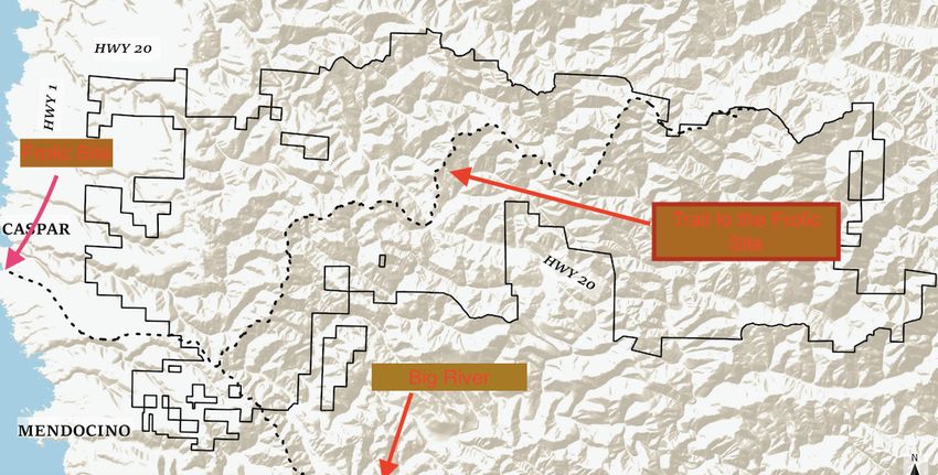
Table of Contents

Executive Summary                               3

Historical Background                           4

Trails, Rails, and Roads                        15

Fire, Carbon, and Climate                       21

Conclusion                                      24

A Proposed Way Forward                          26

Selected Bibliography                           28

Appendix 1: Maps                                29

Biographical Notes:                             35

                                    2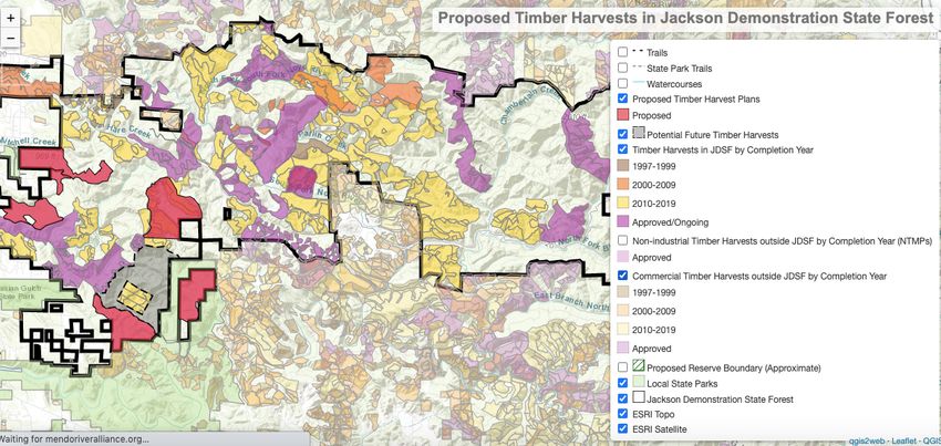
Executive Summary

        The 2016 update to the Jackson Demonstration State Forest (Jackson) Management Plan (Plan)
and supportive databases, map research, and on-site observations all indicate that management of the
existing 48,652 acres of public lands within Jackson warrants a new perspective on how continued
forest practices that allow for new road building and timber extraction is contrary to existing
ecosystem transformations due to climate change.

        This paper is intended to foster new discussions and new policies on how Cal Fire, the agency
tasked with managing Jackson, can modify the existing Plan to accommodate California’s landmark
legislation requiring the state to reduce its overall greenhouse gas emissions to 1990 levels by 2020
and 40% below 1990 levels by 2030. Assembly Bill 1504 monitors the initial target established for
California forests to sequester 5 million metric tons of carbon dioxide equivalent annually until 2020.1
(The most recent data available). California aims to become carbon neutral by 2040. One way to
partially achieve these goals is through redwood forest preservation. The vast majority of forestlands
within Jackson is maturing second-growth redwood (Sequoia sempervirens). These trees have been
proven to be the greatest carbon sequestration plants on earth. “A fervid new push is being made to
protect and restore previously clear-cut coast redwood forests after studies documented how they store
more carbon than any other tree, a characteristic that researchers believe could be used as a bulwark
against global warming.”2

       According to Ernest Moniz, former US Energy Secretary, “We need every option we can
generate for low carbon.”3

        This paper will advance the argument that a forest management plan formulated on outdated
technologies and practices does not meet the needs of today’s critical climate change challenges. The
paper will show that recreational visitation in Jackson and Mendocino County is on the rise.
Additionally, the fire danger associated with the fuel loads added to the forestlands from various past,
current, and planned timber removal “demonstrations.”

        Finally, this report will show the damage logging roads and skid trails have had to ancient
Native American trails through Jackson. It will present maps, data, and research on why a short-term
moratorium on timber harvesting is in order to sort through both the outdated model of extraction
currently employed in the forest, and the need for increased dialogue between all stakeholders
including recreational users, tribes, and elected officials who will ultimately help determine the path
going forward for best and wisest use of these public lands. The paper concludes with the author’s
suggested solution for going forward.

1
  USDA Research and Development. See at: www.fs.fed.us accessed on 19 March 2021.
2
  “New reason to conserve redwoods - they're best at storing polluting carbon,” SF Chronicle, 30 April 2020,
https://www.sfchronicle.com/environment/article/New-reason-to-conserve-California-s-redwoods-15238034.php
3
  Ernest Moniz, President of Energy Futures Initiative: see at: www.earth.stanford.edu Accessed on 19 March 2021.

                                                           3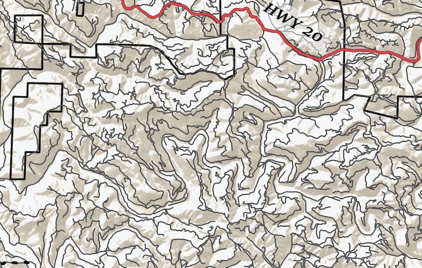
Historical Background

        Raymond M. Rice4 may have phrased the conundrum between preservation and extraction best
when he stated, “Aggravating the conflict of world views is the reluctance of politicians to avail
themselves of the science that there is to quantify opposing values and strike a balance that is in the
public’s interest. That is what I call the ‘how many salmon eggs per board foot problem.’”5 He
clarifies his position in a section entitled “The Political Arena.” “Industry views its land as a tree farm
whose management should be free of infringements on an owner’s property rights as a wheat farmer’s.
Environmentalists—and to a large extent the general public—view the owners of forest land as
custodians of natural resources who should be subjected to public oversight.”6

        The story of management of Jackson Demonstration State Forest begins within the history of
the land, pre and post European encroachment. Well-documented in the archeological and cultural
history literature, no brief overview here can give justice to the 10,000 years or more of Indigenous
presence in the hills, valleys, and forests of Mendocino and Lake Counties. Selected referenced works
to that body of research are found below.7 “The Xa-Ben-Na-Po Band of Pomo Indians inhabited the
region (the area around Mount Konocti) as many as 12,000 years ago – 4,000 years before Egyptian
civilization. Mount Konocti was revered as sacred by the peaceful tribes, who numbered in the
thousands until the early 1800s.”8 Professor Thomas Layton has accurately reported in The Voyage of
the Frolic on the evidence found at the Frolic wreck site on the Mendocino Coast and the influence the
chance grounding of that that schooner had on the Pomos who lived both along the coast and in the
interior valleys.9 When the bounty of the region was discovered by the Europeans, the Indigenous
people were corralled into reservations, resulting in the need for a fort and garrison at Fort Bragg. The
First People were then unceremoniously marched at gun point from their ancestral lands to reservations
inland, so that the massive extraction of trees could begin. Many tribes were forced to live within tight
boundaries with numerous competing tribal neighbors, who in some instances had proven in the past to
be less than friendly.

      More information and the importance of the archeological find of the charmstone on Three
Chop Ridge within Jackson (shown on the title page) will be covered below.

       Between the grounding of the Frolic in 1850 and this writing, nearly all of the old growth
redwoods in Mendocino County have been converted into lumber. Soon after a party of treasure
seekers looking for the contents of the Frolic arrived on the coast, lumber mills sprang up on nearly

4
  Formerly Chief Research Hydrologist, Pacific Southwest Research Station, USDA Forest Service.
5
  Rice, Raymond M. “Why Caspar Creek — then and Now,” Proceedings of the Conference on Coastal Watersheds: The
Caspar Creek Story, USDA General Technical Report PSW-GTR-168, June 1998, p.12. Hereafter cited as Proceedings.
6
  Rice, p.12.
7
  Kroeber, A.L. Handbook of the Indians of California (Chapters 15-17), Dover Publications, New York, 1976; Aginsky,
B.W. and E. G. Deep Valley. Stein and Day, New York, 1967; Brown, Vincent. Pomo Indians of California and their
Neighbors, Naturegraph Publishers, August 1, 1969; Kennedy, Nia. The Pomo (Spotlight on the American Indians), January
15, 2018; Clark, Cora, Pomo Indians: Myths and Some of Their Sacred Meanings, June 5, 2011. Et. Al.
8
  https://lakecounty.com/explore/history-of-lake-county-california/ accessed on 19 March 2021
9
  Layton, Thomas. The Voyage of the Frolic. University of Stanford Press, 1997.

                                                          4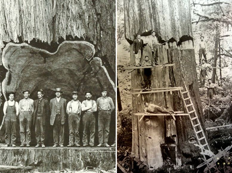
every creek and river mouth, in valleys, and in long flat stretches of the county’s numerous streams.
Wonderfully documented in several books by local authors, (see below and in the accompanying
bibliography), the era of falling, bucking, jack-screwing (the early method of moving large logs by
hand), hauling and sluicing giant redwoods to these sawmills became the economic backbone of the
County for decades.10 As recently as 1968 there were 33 sawmills, railroad tie camps, and shingle
mills operating in the County.11 Today, just two major sawmills exist in the entire county.

        Extraction methodologies change over time. This is as true of the timber industry as it is with
any commercial mining or fishing operation. And it is surely true that as technologies change, so too
does the rapidity of extraction. These increases in delivery time drove the supply and demand of the
product, redwood lumber. Witness the ancient logging techniques used in the mid-1800s: hand axes,
whip-saws, jack screws and yoked oxen were used to drag the logs to the mill. Compare that with
today’s chainsaws, tractors, yarders, and logging trucks. In the early years of timber harvest, it might
take several days to lay out a falling bed of small tress for a single large redwood so the brittle old
growth tree would not shatter upon felling. The woodsman then had to create a springboard system get
high enough on the tree base to cut the undercut by hand axe. Then the back cut began with a two-man
“misery whip,” which led to the tree landing (if all went right) onto the bed. Clearing even an acre of
these giants was a slow and methodical man vs. nature undertaking. But evidently, given the
proliferation of charred old growth stumps in the woods today, these hardy men were up to the task. In
the span of one hundred years of logging, now only approximately five (5) percent of the old-growth
coast redwood forest remains.12

                                                                                                      13

Figure 1: Decline of Old Growth (OG) Forests through the decades
10
   See: Holmes, Alice. Mills of Mendocino County: A Record of the Lumber Industry, 1982—1996, January 1, 1996;
Jackson, W. Francis, Big River was Dammed, FMMC Books, 1991; and https://rootsofmotivepower.com/wp-
content/uploads/2018/03/Roots-Of-Motive-Power-Highline-2009-April-Vol-27-01.pdf.
11
   Timber Resources of Mendocino and Sonoma County, USDA Bulletin, 1972.
12
   https://www.savetheredwoods.org/about-us/faqs/ Accessed on 20 March 2021.
13
   https://www.reddit.com/r/MapPorn/comments/axau4e/map_of_virgin_forest_in_the_usa_through_the_years/ Accessed
on 20 March 2021.

                                                        5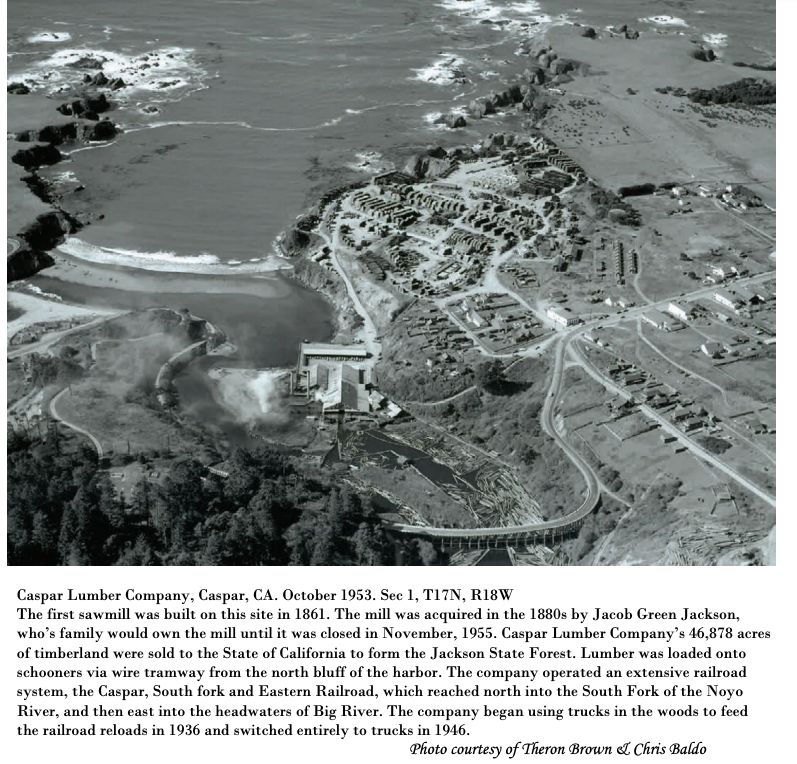
The photo on the left shows fish passage and
                                                      the spawning habitat in Caspar Creek have been
                                                      seriously compromised due to past logging
                                                      practices. Resource management’s bottom line in
                                                      extractive businesses was, and continues to be,
                                                      the investment quotient of timber operators, mill
                                                      owners, and shipping companies so that they
                                                      make money. The faster logs could/can be cut
                                                      into lumber and the quicker it came on the
                                                      market the bigger the asset total on the profit and
                                                      loss books. The timber industry seems to have
                                                      ignored the plants, animals, fish, and integrity of
                                                      watersheds from where the product came. More
                                                      than half of the contents of Proceedings
                                                      (previously referenced) deals with logging
                                                      impacts of channel form, erosion and suspended
                                                      sediment, and effects on aquatic vertebrates and
                                                      habitat in the North Fork of Caspar Creek.
                                                              Figure 3 below shows the layout of the
                                                      Caspar Mill, the final destination for the logs
                                                      heading west from the hillsides to the sawmill.
                                                      Note the curving bridge spanning the creek at the
                                                      bottom of the photograph. During hours of
                                                      operation prior to the mill’s closure in November
                                                      1955, auto trips from or to Fort Bragg on this
                                                      section of State Highway 1, allowed travelers to
                                                      witness from their cars the huge logs from up
                                                      river being rolled over the high embankment and
                                                      splashing into the mill pond. (Personal
                                                      observations of the author).
Figure 2: Logging with the Flying Machine
on Caspar Creek14

        Above (Figure 2) is an example of what logging looked like as the introduction of a new
technological invention began harvesting trees on Caspar Creek (probably the North Fork) in the late
Nineteenth Century. Called the “Flying Machine,” because it could move relatively quickly up the
creek beds, the mechanism used steam and winch power. It greatly reduced the time it took to strip
entire watersheds of timber and could deliver logs to the mill in record time. Tractor logging was the
next major logging invention that changed the way operations occurred in the woods. Large Caterpillar
tractors, introduced in the 1920s, could move logs more efficiently, create new roads with ease, and
generally increase the speed with which logs could be moved downriver to the mills.

14
     From the author’s private collection.

                                                  6
Figure 3: The Caspar Mill and Lumber Drying Yard

                                                  T

        One of the most revealing clues we have to this extraction period in human history comes from
a cartoon entitled Birth of a Toothpick. This animated short clearly shows the “It’s only just a tree”
mentality that ruled the timber industry. “Who needs to strap Nellie to a sawmill log when the heroine
herself has become the log! The Birth of a Toothpick, released in 1939, is unlike anything else made

                                                  7
during this period at Lantz. It might be offbeat, but the commitment to its joke is played full-throttle
for laughs.”15

        Sylvia, the giant redwood in the cartoon, may have been a simple metaphor for recreating
nature for human benefit. But there is more to this story if we analyze the message further. Dan, the
tree-hugging, Scandinavian-accented, lover of nature presents a contrasting viewpoint to the attitude
that nature is there to help humans achieve the Biblical mandate to “be fruitful and multiply.” And
while early Mendocino pioneer, Nathaniel Smith’s, boast that he netted 15,000 pounds of salmon in ten
minutes, may be an example of tall-tale braggadocio, we do know from Jackson’s Mendocino City, A
Daily Journal — 1852-1938, that the trees cut during the period were large, and that the abundance of
wildlife and fish in the watersheds and marine environment was prodigious.

               •   Two men caught 250 trout (steelhead) as the trout law had expired. 1 April 1881 (p. 67)
               •   W.H. Kelly and Fred Brown joined forces in delivering 371,982 feet of redwood logs to
                   the Company. 31 July 1857. (p. 13)
               •   The mill sawed 102,000 feet of lumber from 157 logs. 28 July 1903 (p. 136)
               •   Chinese shipped out 11 boxes of clams taken from the (Big) River.
                   (The Chinese were brought in to strip the River of its clams). 25 October 1913 (p. 193)
               •   24 salmon were caught on Big River by a young man using a trolling outfit. 15
                   November 1902 (p. 208)
               •   John Walsh harvested 7083 pounds of merchantable potatoes on 1/3 of an acre located
                   on Lansing Street. 16 November 1912 (p. 208)
               •   Combined high tide and storm waters from a heavy rain brought down 7,000 logs into
                   the Boom. 20 November 1900 (p. 210)
               •   79 nice big fellows, as Nathaniel Smith seined a great haul of salmon on the river. (Fish
                   sold for 25 cents each). 6 December 1900 (p. 221)
               •   Five inches of rain fell in less than 24 hours. 10 December 1937 (p. 223)
               •   Joe, the Italian fisherman, caught five sharks in the bay. The largest one was over five
                   feet in length and weighed more than 100 pounds. 2 January 1886 (p. 9)
               •   Harry Boos, Tony Gomes and Joe Andre were given a bad time by a shark while they
                   were fishing just offshore. A 30-foot shark stayed near their boat, bumping into it, at
                   which point they sped for shore. 29 February 1920 (p. 43)
               •   J. S. Neto and Ruel Armas landed a 103-pound halibut. 21 September 1904 (p. 173)
               •   53-pound codfish caught in the Bay by fisherman Joe Luce (Lenhares), Joe Vierra and
                   Domingo Valador. 2 September 1914 (p. 163)16
               •   Also noted by Jackson in Big River was Dammed is the location on Railroad Gulch (Big
                   River watershed) of a tree 19.5 feet in diameter. It is unclear if this tree was still
                   standing at the time he wrote the book, but onsite research on that section of the
                   watershed did not reveal a tree or stump of that size. Further research is necessary.

                                                                T

15
     https://cartoonresearch.com/index.php/the-birth-of-a-toothpick-1939/ Accessed on 1 April 2021.
16
     Jackson, W. Francis. Mendocino City: A Daily Journal—1852-1938, Mendocino Historical Research, Inc.

                                                            8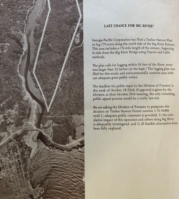
Figure 4: A few nice ones. Ling cod caught on a typical fishing excursion along the Mendocino Coast
in the early days. Note the handline used in right hand of fisherman on left.

                                                      T

       In more recent logging history, production of old growth redwood peaked in the early 1960s
and waned as the decade closed. Timber harvest in the county in 2005 was 120,841,000 board feet with
a market value of $89,441,000 (Table 4-B and Figure 4-3 in County General Plan), which decreased to
103,031,000 board feet valued at $74,594,400 in 2007.17

       Like it or not, a new paradigm is emerging, one that drives the local economy:

               Lodging and tourism promotion is (sic) vital to Mendocino County’s economy because
       of the impacts of visitor spending on taxpayers, businesses and employees. In 2018, the most
       recent year for which complete baseline information is available, total direct travel spending in
       the county increased 9.15% to $482.2 million. Tourism remains a notable employer within the

17
  Mendocino County General Plan: https://www.mendocinocounty.org/home/showpublisheddocument?id=5234 Accessed
on 20 March 2021.

                                                     9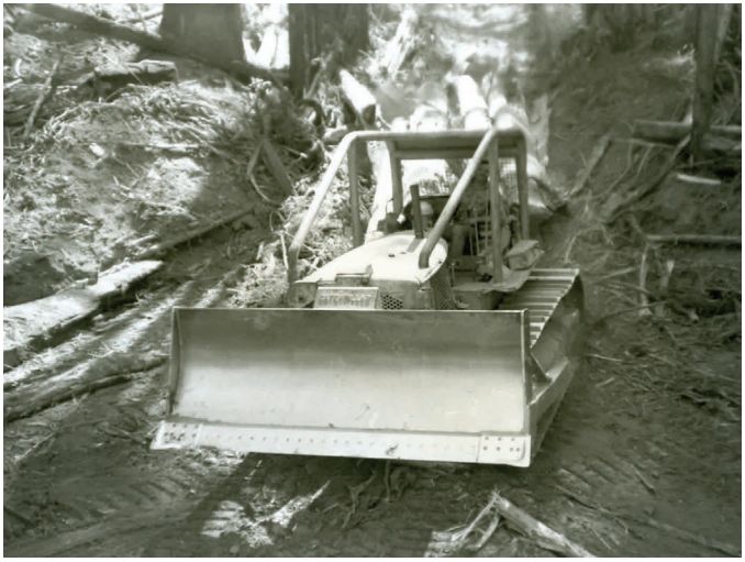
county with the industry supporting 6,900 jobs and generating earnings of more than       $214
           million.18
                   Tourism has become very prominent in Mendocino County over the last 20            years.
           In 1998, direct visitor spending in Mendocino County was $257.9 Million. It grew to $342.7
           Million in 2008. Due to the recession, tourism spending bottomed out at $331.1 Million in
           2010. Growth was minor through 2013. The market began to pick up again in 2014, with
           significant growth through 2017, which had total direct visitor spending of $456 Million. This
           is an overall increase of 77% between 1998-2017.19 Preliminary numbers from Dean Runyan
           & Associates provided by Visit Mendocino show tourism spending increased to $482 Million
           in 2018, a year-over-year increase of nearly 6%.
                   Timber represents the second highest value commodity, with a gross “at mill” value of
           $102,000,000. Mendocino County ranked 4th in the state in timber volumes and produced
           roughly 7.6% of the state’s total timber harvest in 2017.”19

           Obviously, something new is happening County-wide.

Figure 5: Wine Industry catches Timber Industry in Mendocino County in 2006.20

18
   Mendocino County Lodging Business Improvement District 2020-2021 Annual Report,
http://mendocinotourism.org/Accessed on 22 March 2021.
19
   Economy: Mendocino County 2018-2019 Economic Assessment: https://www.edfc.org/wp-
content/uploads/2015/12/FINAL-2018-2019-Mendocino-County-Economic-Assessment.pdf Accessed on 22 March 2021.

20
     County Plan, p. 4-28.

                                                      10
\
Figure 6 & 7: Use of Cat on Albion river circa 1950. 21
Figure 8: Log jam on Big River
21
https://rootsofmotivepower.com/wp-content/uploads/2018/03/Roots-Of-Motive-Power-Highline-2009-April-Vol-27-
01.pdf Accessed on 20 March 2021.
11.
Stock photos from internet showing size of trees felled.
The effects of continued tree harvest on watersheds began drawing forester’s attention in the
early 1990s.
By the mid-1990s, erosion incidents related to these roads were increasingly
frequent. In 1994, a detailed landslide survey of the South Fork Caspar Creek watershed
documented 10 significant features estimated to have occurred within the last five years. Nine
were related to the road and skid trail system. In 1995, two additional failures occurred as a
result of deteriorated steel culverts and displaced 434 cubic meters (568 cubic yards) of
sediment, routing most of the material directly to the perennial stream channel. During the
1997-1998 El Niño storm season, five large road-related landslides occurred in the South Fork
watershed, displacing 1,675 cubic meters (2,190 cubic yards) of sediment. Two additional
landslides occurred, displacing 568 cubic meters (743 cubic yards) of material, but these were
not related to the road system built in 1967 (Cafferata and Spittler 1998). p.6.22
Studies in Jackson Demonstration State Forest point to an alarming new erosion situation in the
forest: “The erosional costs associated with road decommissioning in this study were significantly
greater than anticipated during project planning.” And,
Evidence from 2006 suggests that the treated roads are relatively small sources of new
erosion, but the remaining skid trail and road system still poses risks in this watershed.
Continuing research efforts in the Caspar Creek watersheds will investigate the implications of
additional watershed restoration techniques, as well as the hydrologic consequences of
additional timber harvest operations. 23
The Caspar Creek watershed history is one of high-density logging use. Norm Henry,
California Department of Forestry researcher once described the history of the watershed this way:
22
https://www.fs.fed.us/psw/topics/water/caspar/pubs/Rd600DecomNote.pdf Accessed on 18 March 2021.
23
Keppeler, Elizabeth T. State Forest Road 600: A Riparian Road Decommissioning Case Study in Jackson State
Demonstration Forest. P. 16.
12In 1860, the Caspar Logging Company was founded, the owners having purchased most of
the Caspar Creek watershed (which eventually was sold to the State of California in 1947). A
sawmill was built at the mouth of Caspar Creek ultimately producing up to 25,000 board feet
of lumber per day. Jacob Green Jackson, after whom Jackson State Forest is named, bought the
mill in 1864 and soon after had three log crib dams built on Caspar Creek. The dams were built
to provide additional stream discharge for river log drives, permitting logging operations to be
expanded into the upper reaches of Caspar Creek. Thirty thousand logs or more were often
tiered in the channel, waiting to be floated down to the mill during high winter flows.24 (See
photo of Big River [Figure 6] log tiering above).
T
Thus, we come to today when the managers of Jackson, through the office of Cal Fire, the
agency responsible for the overall health and welfare of the entire acreage within the forest, continue to
“demonstrate” various logging techniques within the boundaries of this public forest.
According to the informational map/brochure developed to welcome visitors to Jackson, “State
forests are used for forestry experiments, and to demonstrate the productive and economic possibilities
of good forest practices, and of maintaining forest crop land in a productive condition. The
management of State forest and the cutting and sale of timber and other forest products conform to
forest management practices designed to promote continuous forest production with due regard to the
preservation of soil, water, scenic wildlife, and recreational values.”25
The history of the watersheds draining the Big and Noyo Rivers, and the Caspar, Jughandle and
Mitchell Creeks reveals how the now-outdated philosophy of resource extraction effects watersheds.
As Nash so concisely puts it, “(Those) involved in the pioneering process revealed a proclivity for the
rural and useful. Wherever they encountered wild country they viewed it through utilitarian spectacles:
trees became lumber, prairies farms, and canyons the sites for hydroelectric dams.”26
The complete dominance of the landscape by the timber industry can be shown in the
photographic evidence available in the Kelley House Museum of Mendocino’s archival record.
Witness below the entire Albion flat covered by the fourth mill on that site:
24
Proceedings, p 1.
25
Welcome to Jackson State Forest, State of California, The Resource Agency, Department of Conservation, Division of
Forestry, map of Jackson. In personal collection.
26
Nash, Roderick. Wilderness and the American Mind. Yale University Press, New Have, 1967, p. 31.
13Figure 9: Albion Flat 1897
Figure 10: How the need to move lumber to market via schooner created impacts on the inner tidal
zone. Albion, 1897.27
27
Two photos from the Mendocino Historical Review, Vol. IV, No. 2, 1974.
14Figure 11: Last Chance for Big River Flyer: In
1976, a section of Big River near the mouth
was about to be logged by Georgia Pacific.
Public input on this important local issue
reversed the decision to cut the timber on that
section. “We are asking the Division of
Forestry to postpone this decision of THP 1-
76-9068M until the cumulative impact of the
operation and others along Big River is
adequately investigated.” The plan was
ultimately shelved and in 2002 the property
became part of what is now the Big River
portion of the Mendocino Headlands State
Park. See drone footage of this section at:
https://www.savetheredwoods.org/blog/spectac
ular-view-of-big-river-mendocino-old-growth-
redwoods-project/
Proving, once again, people do have a voice!
Trails, Rails, and Roads
Any discussion of roads should take into consideration the Working Guidelines from the
National Marine Fisheries Service. “Road density values . . . are compared to a threshold of 3 miles of
road per square mile.”28 According to National Marine Fisheries Service’s working guidelines,
watersheds over the 3 miles of road per square mile threshold are characterized as “not properly
functioning.”29
Watershed and road analysis of lands adjacent to Jackson are relevant when discussing
conditions within Jackson simply because so much of the state forest timber production lands are in the
Big River watershed to the south of Jackson, or the Noyo river on the north of Jackson. A Klamath
Resource Information System (KRIS) Noyo study reveals that road densities average 6.7 mi/sqmi in
the Noyo basin. Research reveals that when the Big River estuary lands were purchased from the
Hawthorne Timber Company in 2002, road densities on that track to land (84 square miles within what
are now the Park boundaries) was 7.4 miles of roads per square mile (mi/sqmi). “It is likely that the
actual length of roads within the Park is higher,”30 due to data relying primarily on aerial photography
and limited ground surveys. (Source cited under #28).
Compare those numbers with the Cal Fire Jackson State Road database. That data reveals an
estimated 350 miles of actively used roads in Jackson, with another 150 miles of potentially
improperly abandoned roads.31 Thus, there are a total of 500 miles of used and unused roads within the
48,652 acres of the forest. With 640 acres to the square mile, it is easy to calculate that Jackson covers
28
Noyo Road Density Information in KRIS.
www.krisweb.com/krisnoyo/krisdb/html/krisweb/noyo_background/roadskris.htm Accessed on 15 March 2021.
29
KRIS Noyo, cited above.
30
California Geological Survey map in private collection. Listed as: www.conservation.ca.gov/cgs 2004, in personal
collection.
31
JDSF Management Plan, p. 213.
15approximately 765 square miles. With 500 miles of roads in that area, the formula of mi/sqmi/road
length equals a road density of 6.57 mi/sqmi within the Jackson.
Refer to Map 7 in Appendix 1 for a graphic picture of road densities in Jackson.
Studies on the sediment loads carried by the sub-tributaries within the entire watershed are
revealed in these quotes from the USDA Forest Service studies done on Caspar Creek:
For the individual subcatchments the median increase in storm sediment load was 107%
in clear-cuts and 64% in partly clear-cut catchments. The median annual sediment load
increase was 109% (58 kg ha-1yr1) from clear-cut catchments and 73% (46 kg ha-1yr-1) from
partly clear-cut catchments. The most important explanatory variable was the increased
volume of streamflow during storms. The increased flows, accompanied by soil disruption and
intense burning, accelerated erosion of unbuffered stream banks and channel headward
expansion.
The principal objective of the 40 years of research in these catchments is to
evaluate the impacts and recovery from road construction and selection and clear-cut
harvesting by tractor and cable on streamflow, suspended sediment, and bedload.
From 1971 to 1975, 50% stem volume of the 90-year-old second-growth redwood
and Douglas-fir forest was selectively cut and tractor-yarded to roads near the stream.
This practice was compliant with forest practice rules in use in California in the early
1970s.
From 1989 to 1991, 50% of the 100-year-old second growth redwood and Douglas-fir
forest was clear-cut and the trees were cable-yarded to roads near the ridge. Buffer strips left
along perennial streams were selectively logged. This practice was compliant with forest
practice rules in use in California in the early 1990s.32
Figure 12: Caspar Creek clear-cut circa 1990.
32
Ziemer, Robert R. “Caspar Creek.” (Pacific Southwest Research Station, USDA Forest Service, United States,
rziemer@fs.fed.us) https://www.fs.fed.us/psw/publications/ziemer/Caspar_Creek.pdf Accessed on 22 March 2021.
16With this amount of clear-cut activity within a three-year period, one can expect an increase in
soil and stream temperatures. “One watershed was clear-cut 5 years after the observations began. After
clear-cutting, the annual mean soil temperature at 0.5, 1.0, 2.0, and 3.0 m depths rose by about 2.2, 2.0,
1.7, and 1.4°C, respectively.”
(See examples of studies at: “Effects of Clear-cutting and Slash-burning on Stream Temperature in
Southwester British Columbia,” Journal of American Water Resources Association, October 1981:
http//onlinelibrary.wiley.com/doi/abs/10.1111/j.1752-1688.1981.tb01309.x; and “The impact of forest
clear-cutting on soil temperature: a comparison between before and after cutting, and between clear-cut
and control sites,” https://doi.org/10.1007/s10310-003-0063-x)
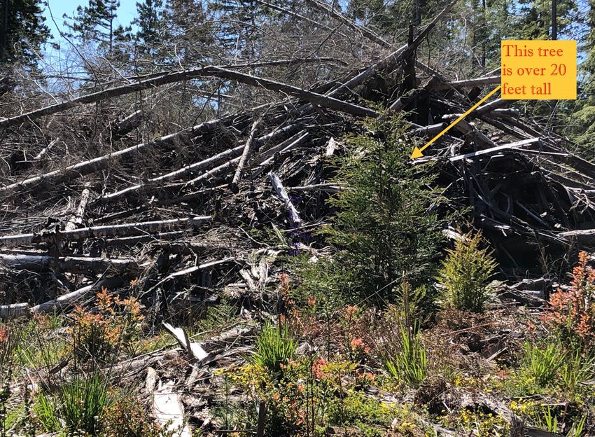
Thus, given the amount of timber removal activity being planned or approved on Jackson (see
Map 2 in Appendix 1) as of today’s date, it is relatively easy to determine that, given the drought-like
conditions California is experiencing, fire danger becomes a reality on these state forest lands. (See
Map 3 in Appendix 1).
New road building and existing road
structures within Jackson contribute to a
number of potential hazards, including the
aforementioned soil and stream warming.
Slash left to rot on the ground, residues of
THPs that failed to remove the downed
limbs, and the brush and regenerative
plants that follow timber harvest, also add
to the fire danger. The argument that
shaded fuel breaks and removing mature
second growth trees decreases fire danger
seems contrary to what is happening on
the ground. A glimpse at the fuel load on
the fringes and within the cut area of the
2018 THP (1-16-124 -MEN) just north of
the end of pavement on County Road 409,
supports the argument that the forests are
less protected from wildfire than they
were before this operation occurred.
Figure 13: Current Drought Severity Index
T
An additional component, and an aspect of road building that is not addressed in the Jackson
Management Plan, is the destruction of the ancient trails once used by the Native American Pomo
People to conduct trade between the valleys inland and the resources and temporary villages on the
17coast. This revealing quote from the Aginskys’ book on the Pomo clearly states how important these
trails were to the first people:
Within the Pomo territory, the tools, implements, and utensils necessary for
occupations, daily life, and specialized activities were traded and exchanged, as well as
bought and sold. Sea otter skins, which were rare and greatly desired throughout the
region, brought high prices. The people from the coast . . . brought sea products of every sort
into the interior: salt, seaweed, sea otter skins, clamshells and so on. In the course of
routine visits and trading expeditions, every thing passed back and forth from the extremes of
east and west, that is from the coast and the Lake through the valleys of the \Russian
River.33
Vinson Brown and Douglas Andrews contend that the original trails “usually followed the
ridges where there were canyons and along the rivers in the large valleys.”34 And this is exactly as one
would expect. Over millennia trails through the wester Coastal Range adopted the path of least
resistance. The “ridge runners,” who according to Brown and Andrews, often used head straps to
support loads approaching 200 pounds surely wanted to decrease the effort by staying high on the
ridges whenever possible.
It is reasonable to believe that the first roads laid down to move logs and merchandise
mimicked these ancient trails. If you wanted to get somewhere, it makes a lot of sense to know the trail
led somewhere. Thus, we have important trails, noted in Brown and Andrews, and in Francis Jackson’s
research, that Highway 20 may have been originally used by the indigenous people to go to and from
the coast. The discovery of the Pomo village on Three Chop Ridge in the 1980s (Professor Layton’s
archeological research site)35 supports the notion that the first trail may have followed what is now
Road 308 (Three Chop Ridge Road) through Jackson. Then proceeding westward, it stayed high on the
ridge heading down County Road 408 to the intersection of Road 500. (See Map 6).
The story of the discovery of the charmstone pictured on the title page is well told in the Papers
on Northern California Archeology:
The charmstone was found on October 23, 1992, by Registered Professional Forester
(RPF) William Windes. Bill was one of 39 students attending CAL FIRE Archaeological Site
Recognition Training Course #27, which was held in the Ukiah area from October 21 to 23,
1992. The third and final day of training consisted of a series of field exercises conducted at
Three Chop Village (CA-MEN-790) in Jackson Demonstration State Forest. A group of about
10 foresters was walking up the road from the main house-pit area. Midway up the road, RPF
Bill Windes, walking behind the others, spotted something in the middle of the dirt road and
brought it to the attention of Dan Foster. The item was a charmstone deeply embedded in the
road; recent grading had exposed the very top of the artifact. When Foster removed it with the
aid of a trowel, it was clear this was an in-situ discovery. The road had cut through an
archaeological deposit and exposed the charmstone.36
33
Aginsky, p. 201-202.
34
Brown, Vinson and Andrews, Douglas. Cited above. p. 41.
35
https://scahome.org/publications/proceedings/Proceedings.21Hector1.pdf Accessed on 20 March 2021.
36
“A Charmstone Discovery in the Redwood Forest of Mendocino County, California;” Hector, Susan M. et. al, in Papers
on Northern California Archaeology, Proceedings of the Society for California Archaeology, Volume 21, 2009, pp. 47-57,
seen at: https://scahome.org/publications/proceedings/Proceedings.21Hector1.pdf Accessed on 14 April 2021.
18. . . the Mato Pomo, with winter villages in Sherwood Valley, generally claimed the coast
north of the Noyo River mouth, while the Mitom Pomo, with winter villages in Little Lake
Valley, claimed the coast to the south. Both Stewarts’s (1943) Mato and Mitom informants
agreed that the coast was used only seasonally, and there were no permanent coastal
settlements in Northern Pomo territory prior to the displacements caused by the coming of
whites. The wreck of the Frolic occurred well within undisputed territory claimed by the
Mitom Pomo. Moreover, the recovery of Chinese ceramics from the Frolic’s cargo at Three
Chop Village (MEN-790), situated at the midway point of the major ridge-line trail
linking the Little Lake Pomo with the coast, is strong evidence that the Frolic was
looted by the Mitom Pomo and that during the late prehistoric and contact periods Three Chop
Village was indeed occupied by Mitom Pomo.
Probably two major trails linked Little Lake Valley with the coast, both ascending
the ridge 8 km west of Willits by following the course of Broaddus Creek to the top of the
divide. From this point, one trail followed Three Chop Ridge along what is today Three Chop
Road, then to Indian Springs Road, ultimately descending the ridge near the intersection of
Highway 20 and Big River Road. From there, a 6 km walk to the west brought the traveler out
of the mountains on to the upper most fifth marine terrace overlooking the Pacific near the
headwaters of Mitchell Creek. Another 6 km walk was necessary to reach the ocean’s edge
at Jughandle Creek, only 3 km north of the Frolic wreck site. The alternate trail route led to
the historic Mitom village of Buldam at the mouth of Big River. It diverged from the Three
Chop Trail near the top of the divide 8 km west of Willits, descended Sevenmile Grade and
proceeded to the coast, following about the same route as the present day Highway 20 and Big
River Road (Stewart 1943:37).37
My personal exploration of these ancient trails began in the 1970s when the owner of Old Mill
Farm (an in holding of Jackson on Road 740), Charles Hinch, suggested we search for trails that he
believed ran close to or through his property just east of Road 500 in Jackson. Chuck was convinced
that areas of Jackson, especially the western portion, should have, under a Senate Bill proposed (SB
1063), “protection of other recreational scenic resources and assure public access, . . . (that) means
protect trails which interconnect these areas. The trails are established and should be recognized as a
vital part of the area.”38
While on several recognizance missions, he and I discovered what we believed were sections of
the original trail. We found on one particularly memorable stretch along Hi Chute Ridge from Road
408 to the Laguna crossing on Big River, numerous obsidian shards in the dirt of the trail bed. These
sections have, unfortunately, been destroyed by logging roads and skid trails in the years since our
discovery hikes in the ‘70s.
The Jackson Management Plan lists no specific requirements or protocols for cultural surveys
of timberlands proposed for harvest because language in the California Environmental Quality Act
37
Stewart, Omar C. Notes on Pomo ethnogeography. University of California Publications in American Archeology and
Ethnology 40(2):29-62. Berkeley:1943; and Layton, Thomas L. Western Pomo Prehistory. Excavations at Albion Head,
Nightbird’s Retreat and Three Chop Village, Mendocino County, California. Monograph 32, Institute of Archeology,
University of California, Los Angeles:1990
38
Hinch, Charles. Trail Preservation Letter to State law makers, circa, 1975. In author’s private collection.
19requires THP applicants (Cal Fire in this case) complete this component. Cal Fire does present a
Cultural Resources Review and Guidelines manual for Cal Fire projects. It includes this statement:
“The primary goal of the procedures are (sic) to ensure resources are identifies (sic) and protected.”39
The premise is as shaky as the faulty grammar in the sentence.
Meanwhile, in the 400 + page Plan, there is a section entitled, “Public Concern Regarding the
Management of JDSF.” Of the fourteen topics listed, carbon sequestration, fire danger, destruction of
ancient trails, and climate change are not listed. Another reason for an updated version of the Plan to
be discussed by all parties involved.
T
During the early days of timber extraction, railroads and their associated trestles and tunnels
were also created in what is now primarily Jackson. Especially important in assessing the impacts
roads and railways had on the trails within Jackson is the little Western Railroader “Enlarged Edition”
issue entitled “Caspar Lumber Company: Caspar, South Fork and Easter Railroad.40
Figure 14: The world’s largest wooden trestle over Jughandle Creek, 1889. (see Maps 4 & 5)
Trails, rails, and roads have undeniably made impacts on both the economics and topography of
the lands through which they pass. One can only guess at the total disturbance of land destabilized by
the early pioneers in their quest to get logs to the mill. There were at least 27 splash dams on Big River
alone. When tripped, the amount of water released floated the old growth (OG) downriver. A careful
survey of the section of the North Fork from Dunlap to the confluence with the Main Fork — even
today — reveals the scouring that occurred during log drivers of both riverbanks. This movement of
water and wood left the corridor stripped of riparian cover and the essential habitat overstory to the
pools used by anadromous fish. It’s important to visualize how much of this habitat was destroyed by
prior logging methodology. Trails became roads, roads led to rail development. This interconnectivity
39
https://www.fire.ca.gov/media/11171/cultural-resource-review-procedures-final.pdf Accessed on 4 April 2021.
40
Borden, Stanley T. Caspar Lumber Company: Caspar, South Fork and Easter Railroad. Issue 315-316, 1966.
20of access to the forests contributed to the greater decrease in slope stability as the removal of timber
progressed through the decades.
The infrastructure to create a system by which the OG could be handled easily enough to
get it aboard a schooner heading to market is in itself a remarkable story. In every sense of the word it
has a Herculean task. Missing from some histories is the problem-solving strategies for such an effort.
For example, the aforementioned Caspar Lumber mill’s need to have a supply of fresh water, delivered
at pressure, to the steam boilers used to power the mill was ingeniously solved. The water flowing
down Caspar Creek was not used because it would have had to be pumped to elevation to create the
“head” necessary for pressure. Early explorers found an ample water source on Doyle Creek, just to the
south of Caspar Creek. Fortuitously, in a very unique geological oddity, two creeks, Caspar and Doyle
empty into Caspar Bay. A low ridge that separates the two creeks. Caspar Graveyard Road runs up this
ridge to Little Lake Road. It would have to be crossed if water from Doyle Creek could be used to
power the mill. That problem was solved by drilling a three-inch hole in the bed rock formation on
Doyle Creek, (a step in the ecological staircase situated at approximately 250 feet elevation) two miles
back from the beach. A pipe diverted the water into a long flume, built on stilts on the north bank of
the creek. Made of OG redwood, this covered flume existed late into the ‘60s. It provided the author
and his friends numerous hours of enjoyment hiking from the beach to the pools upstream. In an
additional footnote to the history of this section of the Caspar operation is the fact that those pools on
Doyle Creek were once stocked with numerous native steelhead fingerlings and resident trout. With
the creation of the fill and culverting of the creek that occurred in the mid-1960s when the new Caspar
bridge was built, the upper reaches of the creek were blocked and the fish could not reach the pools
east of the highway.
Thus, we come to the conclusion that the alterations of the landscape, the removal of mature
trees, and the absence of restoration post-timber removal all resulted (and continue to result) in a
landscape that begs for relief. An informative map showing the past and present logging activities from
1997 to the present allows us to infer that a shift from mature native forests to managed commercial
timberlands has occurred in the past two and half decades:
http://mendoriveralliance.org/Webmapping/index.html#11/39.3555/-123.5639 (See in Appendix 1).
Fire, Carbon, and Climate:
Next, we come to today’s situation in the forest of the coast range, and specifically, the public
lands with Jackson. For the County of Mendocino, and perhaps across the globe, three factors
comingle to present a dire forecast for the future: increased fire danger, the lack of carbon
sequestration due to past and present logging activities, and climate instability as it relates to global
warming and changes in the weather patterns on the planet. Driven by increased human resource
extraction and predicated on the assumption that there is such thing as a free lunch, these changes
reflect a denialism that resources have a finite limit.
The problem of balancing the global need with the local situation has never been more
important. We can examine the record for clues about how to approach the best methodologies
regarding storing carbon, reducing fire risk, and adapting to the challenges of a changing climate.
Within the record are hints that using existing guidelines on cumulative impacts can make a difference
in these areas. Longstanding legal definitions on cumulative impacts have existed for decades. The
Council on Environmental Quality (CEQ Guidelines, 40 CFR 1508.7) was issued in 1971. These
impacts include all impacts that are influenced by multiple activities or causes. And as this paper
21explains, the impacts on the watersheds of the Noyo, Caspar, and Big Rivers have over the years been
quite extensive.
Of interest and importance to the local environment is the fact that the California Department
of Forestry (now Cal Fire) uses a locale-specific analysis to address cumulative impacts when
reviewing timber harvest plans on both state and private lands. (CDF 1998). However, the definition
has been updated within the California Environmental Quality Act: “Cumulative impacts can result
from individually minor but collectively significant projects taking place over a period of time”
(California Code of Regulations [C.C.R.] Section 15355). “In other words, a project that you’re
evaluating within a certain area may contribute to a larger impact/effect if you look at other projects in
that area.”41
As Leslie Reid explains,
(The CDF) approach is potentially capable of addressing the full range of cumulative impact
evaluations that might be important in an area. A standardized impact evaluation procedure
could not be developed because of a variety of issues that might need to be assessed, so
analysis methods were left to the professional judgment of those preparing timber harvest
plans. Unfortunately, oversight turned out to be a problem. Plans were approved even though
they included cumulative impact analyses that were clearly in error. In one case, for example,
the report stated that the planned logging would indeed introduce sediment to streams, but that
downstream riparian vegetation would filter out all the sediment before it did any damage.42
In a recent video conference, Helge Eng, Deputy Director, Resource Manager for Cal Fire, made a
similar preposterous claim. He stated that logging actually reduces wildfire danger and that operations
that log redwoods actually sequester carbon by turning trees into lumber which store carbon. (Caspar
Community meeting 21 March 2021) Given the fact that Cal Fire is currently allowed, under California
law, to give themselves approval for harvest plans they write for cuts within state forests, it may not
surprise anyone that oversight for their stated mandate that “timber production will be the primary land
use on JDSF,”43 is scrutinized by staff who are employed by Cal Fire to further this primary goal. This
conflict of interest, while obvious, does not halt the agency from proposing and then approving the vast
majority of plans they submit to themselves.
As Cal Fire explains on their website:
CAL FIRE does not have the authority to deny a THP that is in compliance with state
and federal rules and laws, simply because the logging plan is unpopular with the public. The
Department reviews and approves between 500 to 1400 THPs each year. A THP that does not
comply with all forestry and environmental regulations is returned to the RPF (Register
Professional Forester). It is only approved after the RPF and landowner agree to make the
changes necessary to ensure compliance with all laws. CAL FIRE follows-up on approved
41
https://ceqaportal.org/tp/AEP%20CEQA%20Portal_Cumulative%20Impacts.pdf Accessed on 1 April 2021.
42
Proceedings, p.118.
43
JDSF Management Plan, p. 1. See at: https://www.fire.ca.gov/media/ncejt2mz/2016-jdsf-mgmt-plan-final_ada.pdf
Accessed on 1 April 2021.
22THPs with site inspections and can shut down operations, cite or fine RPFs, Licensed Timber
Operators (LTOs), and landowners if illegal operations are found.44
No statistics were found on the website to explain what happens when the public posts
commentary on specific plans through the channels of the permit process. Under CEQA requirements,
public comments must have a response from the applicant for the THP that mitigates or explains how
potential areas of concern raised in the public comment period are to be addressed in the final
prescription for timber removal.
These legal needs, and the political ramifications that go hand-in-hand with the decisions that
create the laws that govern the process, are only one part of the overall scope of the actual work.
Consider: the factors inherent in turning a living tree into a piece of lumber are contingent on the use
of fossil fuels and present a rather heavy carbon footprint when taken as a whole. Here are the steps
necessary to get that redwood con-heart 2x4 to market.
Once the THP is approved, a road must be constructed or maintained to allow the RPF to
access the area to be logged. This is accomplished in nearly all cases by driving to the site (use of
fossil fuels necessary, noted here as FF).
• Once the trees are marked for removal, the timber fallers drive to the site (FF).
• Chain saws are used to fell the trees (FF).
• The trees are bucked and limbed (FF).
• A skid road is created to get to the downed trees (FF).
• Trees are skidded out to a landing and stacked (FF).
• Logging trucks arrive at the landing to receive the logs (FF).
• Log loaders are used to place logs onto the logging trucks (FF).
• The logging trucks drive to the mill located at the end of narrow, steep coastal roads
(FF).
• Log loaders are used to unload the trucks (FF)
• Logs are stacked into piles at mill (FF).
• Logs are placed on conveyer belts (FF).
• The mill, if run by electricity that comes from coal-fired, or natural gas powered,
electrical plants, cuts and planes the wood (FF).
• The lumber is graded and conveyed to stacks or air dried in kilns (FF)
• The finished wood is transported by truck to supply houses (FF).
• At the lumber yard the finished lumber is stacked and sorted (FF).
• Consumers have lumber delivered to job sites or transport it themselves (FF).
This is the price (carbon footprint) we pay for finished lumber for construction. In California
alone, multiply this process by between 500 to 1400 times (see above) and what we get is a heavy price
the planet is paying for the convenience of having sawn lumber readily available for our building
projects. But what exactly are these redwood trees, now converted to dimension lumber, being used
for? Decks, furniture, fences, structural beams and trim are the most common redwood uses. Roof
shakes, siding, and other fire exposed redwood on new constructions are now not recommended in
Mendocino County by the Mendocino Fire Safe Council. Which raises the question, if redwood, once
predominately used to side buildings, is being replaced by non-combustible materials in new
44
https://www.fire.ca.gov/programs/resource-management/forest-practice/# Accessed on 1 April 2021.
23constructions, why do we need to continue removing these bastions of carbon sequestration from the
forests? “A typical tree will sequester (remove from the atmosphere) about 1 ton of carbon in its
lifetime. A coast redwood will sequester 250 tons of carbon. Just one coast redwood has the ability to
absorb as much carbon as 250 ‘regular" trees.’”45
This is the question Cal Fire must answer: If we are to meet the State’s goals of reducing the
carbon footprint and become carbon neutral in the near future, what sense does it make to remove the
greatest carbon sequesters on the planet?
California has become a leader in advancing the changes necessary to address climate change.
Harnessing the innovative spirit of California, Governor Gavin Newsom today
advanced an executive order enlisting California’s vast network of natural and working lands
– forests, rangelands, farms, wetlands, coast, deserts and urban greenspaces – in the fight
against climate change. A core pillar of Governor Newsom’s climate agenda, these novel
approaches will help clean the air and water for communities throughout the state and support
California’s unique biodiversity. Harnessing the innovative spirit of California, Governor
Gavin Newsom today advanced an executive order enlisting California’s vast network of
natural and working lands – forests, rangelands, farms, wetlands, coast, deserts and urban
greenspaces – in the fight against climate change. A core pillar of Governor Newsom’s
climate agenda, these novel approaches will help clean the air and water for communities
throughout the state and support California’s unique biodiversity.46
Conclusion:
The above historical examination of the record of destruction on watersheds in the coastal
range leads to the conclusion that what we have done is simply not sustainable. The near future is
framed in increasing fire danger, climate change, and the lack of predictable outcomes. The question
that began this discussion was, “How many salmon eggs should we protect compared with the amount
of board feet of lumber we should extract from the forests.”
That question should be continued to be asked, but there is a new interrogatory that cannot be
ignored: How many wildfires must we endure because the forests are hotter and drier due to over 150
years of logging practices? It seems clear that the past record supports a conclusion that enough is
enough. Mendocino’s economy has already had an extraction climax. A restoration economy is on the
horizon. Recreational use of the beaches and forests of the County is on the rise.
Jackson Demonstration State Forest is the ideal site for recreation expansion along the
Mendocino Coast. The local state parks are filled to capacity in the summer months as tourism
continues to increase along the coast. The combined area of all the parks is a fraction of the size
of JDSF, as well as being home to a lower percentage of redwood forest. Increasing camping
and fishing opportunities in the state forest will provide alternatives for recreational enthusiasts
45
https://www.sciencedirect.com/science/article/pii/S0378112719316718 Accessed on 2 April 2021.
46
“Biodiversity and Boost Climate Resilience.” Published: Oct 07, 2020. From the Office of governor Newsom. See at:
https://www.gov.ca.gov/2020/10/07/governor-newsom-launches-innovative-strategies-to-use-california-land-to-fight-
climate-change-conserve-biodiversity-and-boost-climate-resilience/ Accessed on 14 April 2021.
24as well as generate revenue for the local economy. As mentioned previously, the population of
Mendocino County is expected to double within 50 years. People will need jobs the timber
industry can’t provide, and tourism-related employment is the most realistic candidate to
absorb this increased labor force.47 Written in 1997, we know Seim’s predictions have come
true twenty-four years later.
Cal Fire Resource Manager, Helge Eng, a part of Cal Fire’s Executive Staff, is now on the
record stating, “We have a mandate to do what we do, and I for one like to believe it’s God’s work.”48
Until this point of view changes, the following quote makes the most sense in terms of how to
proceed.
The state ought to be restoring this publicly owned treasure for its precious ecological
and recreational values, not logging it like another big industrial company, said Paul Hughes,
(ED of Forests Forever). The Jackson State Forest area proposed for logging constitutes an
island of public land in the midst of a half-million acres of industrially owned, devastated
redwood timberland. Jackson State Forest is the only tract that realistically could serve as a
large sanctuary between San Francisco and Humboldt County for salmon and other endangered
redwood-related species. It could also be a recreation haven for the millions of people who live
in the Bay Area and Central Valley.49
Scientists across the globe are working to address climate change. Second-growth redwoods
seem to have emerged as a key to removing carbon from the atmosphere. It makes sense to preserve
these trees as we try to figure out the best next steps forward. For the current status of research of
redwood forest restoration, please see the work of Will Russell, Ph. D. in the Open Journal of Forestry
10.50
While that important work is being done, Cal Fire can step up to the plate and refrain from
continuing to log public property and leaving behind piles of slash that become tinder for wildfire. As
we enter into this historically dry period of low rainfall, lack of fog, and hotter temperatures, this is the
least they can do for the residents and visitors of Mendocino County.
Caspar Creek’s South Fork today, 14 April 2021, is barely a trickle. Adult Coho salmon were
able to spawn there this past winter. Young of the Year (YOY) are present in many of the pools. Yet, if
the creek dries up this summer, these tiny fish will die.
Hotter temperatures due to increased logging demonstrations are the last thing these
endangered species need. So, the original question might best be answered by stating that millions of
Coho salmon eggs are needed per zero board feet of redwood extracted from the forest. If these fish
47
Seim, Jeremiah. Jackson Demonstration State Forest: Background, Issues, and Alternatives -- Draft for the Dharma
Cloud Foundation 1997.
48
Mendocino Voice, 13 April 2021. See at:https://mendovoice.com/2021/04/cal-fire-wants-to-begin-timber-harvesting-in-
jackson-a-coalition-of-activists-has-other-ideas-tree-sit-continues-in-jackson-demonstration-state-forest-with-major-protest-
monday-morning/ Accessed on 14 April 2021.
49
https://www.forestsforever.org/archives_resources/press/loggingrelease.html Accessed on 30 March 2021
50
Russell, Will. “Herbaceous Understory Indicators of Post-Harvest Recovery in Coast Redwood (Sequoia sempervirens)
Forests.” Open Journal of Forestry. Vol.10 No.2, April 2020. Accessed on 10 April 2021.
See at: https://www.scirp.org/journal/paperinformation.aspx?paperid=98734
25You can also read