The International Network for Alpine Research Catchment Hydrology (INARCH) - GEWEX
←
→
Page content transcription
If your browser does not render page correctly, please read the page content below
The International Network for Alpine Research
            Catchment Hydrology (INARCH)

Proposal to the GEWEX Hydroclimatology Panel (GHP) for a second
term of INARCH, 2021–2026
Website: https://inarch.usask.ca/

INARCH Chair: Distinguished Professor John Pomeroy, Canada Research Chair in Water Resources and
Climate Change, Centre for Hydrology, University of Saskatchewan, Canada https://research-
groups.usask.ca/hydrology/people/profiles/john-pomeroy.php

INARCH Co-Chair: Professor Juan Ignacio López Moreno, Dep. Procesos Geoambientales y Cambio
Global, Instituto Pirenaico de Ecología, C.S.I.C, Spain, http://www.ipe.csic.es/lopez-moreno-j.i.

Science Manager: Dr. Chris DeBeer, Centre for Hydrology, University of Saskatchewan, Canada
https://gwf.usask.ca/profiles/people/chris-debeer.php

Background
INARCH began as a GHP cross-cutting project in 2015 and since then has grown to a network of 50 research
scientists with wide-ranging expertise from around the world, and 29 experimental research basins in 14
countries covering key mountain regions on most continents. Since its inception, INARCH has made
significant advances in understanding and predictive modelling of the high mountain water cycle,
contributing significantly to multiple international science initiatives, organizations, and other
stakeholders (see https://inarch.usask.ca/science-basins/phase-i-achievements.php). The network
adopted a philosophy and commitment to open data, with major efforts to compile these data in a special
issue of the journal Earth System Science Data titled "Hydrometeorological data from mountain and alpine
research catchments" with 23 datasets (https://essd.copernicus.org/articles/special_issue871.html).
Throughout its time as a cross-cutting project, the network has remained engaged and scientifically active,
and while the COVID-19 pandemic has resulted in a hiatus in in-person meetings and some fieldwork, a
considerable amount of progress has still been made, as shown during an online workshop held recently
(https://inarch.usask.ca/news-events/inarch-2021-online-workshop.php). This is a testament to the

                                                                                                         1
perseverance and innovation of the group. In recent months the INARCH leadership has been considering
future directions for the program and potential science questions following from the progress made
during the first term of INARCH (2015–2020). The recent online workshop was held to refine the specific
science questions and develop a collective vision and plans for a second term of the network. This
proposal describes this vision and summarizes the plans that were made.
Participants
The membership of INARCH has undergone change since the network began and remains open to join for
those interested in linking with INARCH whose research is aligned and who focus on alpine research
catchment hydro-meteorology. Participants during the first term are listed on the archived website here
https://gwfnet.net/sites/inarch/participants.html. Moving forward, INARCH participants are listed at
https://inarch.usask.ca/org-people/, although the network is broader than this, with many other affiliated
researchers, post-doctoral fellows, and students contributing to the overarching program goals and
deliverables, and participating in workshops.
At present, the participants are:
John Burkhart, Department of Geosciences, University of Oslo, Oslo, Norway
Wouter Buytaert, Faculty of Engineering, Department of Civil and Environmental Engineering, Imperial
College London, London, England
Sean Carey, School of Earth, Environment & Society, McMaster University, Hamilton, Canada
Jono Conway, National Institute of Water & Atmospheric Research Ltd (NIWA)Lauder, New Zealand
Nicolas Cullen, School of Geography, University of Otago, Dunedin, New Zealand
Chris DeBeer, Centre for Hydrology, University of Saskatchewan, Saskatoon, Canada
Stepehn Dery, Northern Hydrometeorology Group, University of Northern British Columbia, Prince
George, Canada
Marie Dumont, Centre National de Recherches Météorologiques (UMR CNRS & Météo-France), Centre
d’Etudes de la Neige, Grenoble, France
Richard Essery, School of Geosciences, University of Edinburgh, Edinburgh, Scotland
Simon Gascoin, CESBIO, Université de Toulouse, CNES/CNRS/INRA/IRD/UPS, Toulouse, France
Alexander Gelfan, Watershed Hydrology Lab, Water Problems Institute, Russian Academy of Sciences,
Moscow, Russia
Isabelle Gouttevin, Centre National de Recherches Météorologiques, Météo-France, Grenoble, France
Ethan Gutmann, Research Applications Lab, National Center for Atmospheric Research (NCAR)Boulder,
USA
Adrian Harpold, Department of Natural Resources & Environmental Science, University of Nevada,
Reno, Reno, USA
Walter Immerzeel, Utrecht University, Utrecht, Netherlands
Peter Jansson, Department of Physical Geography, Stockholm University, Stockholm, Sweden
Tobia Jonas, WSL Institute for Snow and Avalanche Research SLF, Davos, Switzerland
Georg Kaser, Institute of Meteorology and Geophysics, University of Innsbruck, Innsbruck, Austria
Franziska Koch, University of Natural Resources and Life Sciences Vienna | boku · Institute for Hydrology
and Water Management, Vienna, Austria
Sebastian Krogh, Departamento de Recursos Hídrico, Facultad de Ingeniería Agrícola, Campus Chillán,
Universidad de Concepción, Concepción, Chile
Vincenzo Levizzani, Institute of Atmospheric Sciences and Climate, National Research Council of Italy
(CNR-ISAC), Bologna, Italy
2Xin Li, Cold and Arid Regions Environmental and Engineering Research Institute (CAREERI), Chinese
Academy of Sciences (CAS), Beijing, China
Ignacio Lopez Moreno, Institute for Pyrenean Ecology (IPE), Spanish National Research Council (CSIC),
Zaragoza, Spain
Yaoming Ma, Institute for Tibetan Plateau (ITP), Chinese Academy of Sciences (CAS), Beijing, China
Danny Marks, Agricultural Research Service (ARS), US Department of Agriculture (USDA), Boise, USA
James McPhee, Department of Civil Engineering, University of Chile, Santiago, Chile
Pablo Mendoza, Department of Civil Engineering, Universidad de Chile, Santiago, Chile
Brian Menounos, Department of Geography, University of Northern British Columbia, Prince George,
Canada
Anil Mishra, Intergovernmental Hydrological Programme, UNESCO, Paris, France
Samuel Morin, Groupe d’étude de l’Atmosphère Météorologique, Centre National de Recherches
Météorologiques, Météo-France, Toulouse, France
Florence Naaim-Bouvet, Institut National de Recherche en Sciences et Technologies pour
l’Environnement et l’Agriculture (IRSTEA), Grenoble, France
Francesca Pellicciotti, Institute of Environmental Engineering, Eidgenössische Technische Hochschule
(ETH), Birmensdorf, Switzerland
María José Polo Gómez, University of Córdoba. Campus Rabanales. Edif. Leonardo da Vinci. 14071 –
Córdoba (Spain), Córdoba, Spain
John Pomeroy, Centre for Hydrology and Canmore Coldwater Lab, University of Saskatchewan,
Canmore, Canada
Dhiraj Pradhananga, Tribhuvan University, Department of Meteorology, Tri-Chandra Multiple Campus,
Kathmandu, Nepal
Rainer Prinz, Department of Atmospheric and Cryospheric Sciences (ACINN), Universität Innsbruck,
Innsbruck, Austria
Roy Rasmussen, US National Center for Atmospheric Research (NCAR), Boulder, USA
Ekaterina Rets, Institute of Water Problems, Russian Academy of Science, Russia, Moscow, Moscow,
Russia
Gunhild Rosqvist, Tarfala Research Station, Bolin Center for Climate Research, Stockholm University,
Stockholm, Sweden
Nick Rutter, Department of Geography, University of Northumbria, Newcastle, England
Robert Sandford, United Nations University Institute for Water, Environment and Health, Canmore,
Canada
Karsten Schulz, Institute of Water Management, Hydrology and Hydraulic engineering (IWHW),
University of Natural Resources and Life Sciences (BOKU), Vienna, Austria
Jean-Emmanuel Sicart, GREATICE project, Laboratoire d’étude des Transferts en Hydrologie et
Environnement (LTHE), Institut de Recherche pour le Développement (IRD), Marseille, France
Delphine Six, Laboratoire de Glaciologie et Géophysique de l’Environnement, Université Joseph Fourier,
Grenoble, France
Sara (McKenzie) Skiles, University of Utah, Salt Lake City, USA
Ulrich Strasser, Department of Geography, University of Innsbruck, Innsbruck, Austria
Julie Thériault, Département des Sciences de la Terre et de l’Atmosphère, Université du Québec à
Montréal, Montreal, Canada
Vincent Vionnet, Environment and Climate Change Canada, Dorval, Canada
Isabella Zin, Laboratoire d’étude des Transferts en Hydrologie et Environnement (LTHE), Grenoble,
France
3Motivation
The motivation for INARCH was clearly articulated in the original proposal and remains true now. In brief,
this includes:
• “In many regions, changing precipitation or melting snow and ice are altering hydrological
systems, affecting water resources in terms of quantity and quality” – IPCC AR4 (2014) WG II
report;
• Alpine catchments receive and produce a disproportionately large fraction of global precipitation
and runoff;
• Snowfall does not equal accumulation on the ground;
• Snow, ice, and phase change domination of alpine hydrology means that it is especially sensitive
to temperature change;
• Alpine regions are data scarce.
According to the 2019 IPCC Special Report on the Ocean and Cryosphere in a Changing Climate
(https://www.ipcc.ch/srocc/) chapter on High Mountain Areas, “Snow cover, glaciers and permafrost are
projected to continue to decline in almost all regions throughout the 21st century” and “river runoff in
snow dominated and glacier-fed river basins will change further in amount and seasonality in response to
projected snow cover and glacier decline with negative impacts on agriculture, hydropower and water
quality in some regions.” The challenges are intensifying and call for immediate action globally. The World
Meteorological Organization (WMO) High Mountain Summit (https://highmountainsummit.wmo.int/en),
held in Geneva in October 2019 issued a call for action that included the following:
• The high mountain regions are the home of the cryosphere, and source of global freshwater that
are transmitted by rivers to much of the world. Preservation of ecosystem function and services
from these regions is essential to global water, food and energy security. Climate change and
development are creating an unprecedented crisis in our high mountain earth system that
threatens the sustainability of the planet. There is great urgency to take global action now to build
capacity, invest in infrastructure and make mountain and downstream communities safer and
more sustainable. This action must be informed by science, local knowledge and based on
transdisciplinary approaches to integrated observations and predictions.
• We, the participants at the WMO High Mountain Summit 2019, hereby commit to the goal that
people who live in mountains and downstream should have open access to hydrological,
cryospheric, meteorological, and climate information services to help them adapt to and manage
the threats imposed by escalating climate change. To meet this goal we commit to an Integrated
High Mountain Observation and Prediction Initiative, organized as collective, intensive campaigns
of analysis and forecasting demonstration projects in key high mountains and headwaters around
the world. The Initiative will co-design solutions, build capacity and suggest investments with
information users, providers and producers to address the front lines of climate, cryospheric, and
hydrological change in support of natural hazard risk management and adaptation in mountain
regions and downstream. We urge the relevant organisations to collaborate and specifically
organize as a matter of urgency, intense observation and prediction campaigns in a WMO Year of
Mountain Prediction. The Initiative will contribute to the desired International Year of Mountains,
and Year of Snow and Ice and will be co-produced and supported by a consortium of national
institutions, international initiatives, user groups, researchers and science networks from policy,
operations, practice and scientific research under the convening leadership of WMO.
4Principal research questions to be addressed
INARCH has completed our Phase I Science Plan and have a suite of well-instrumented research basins,
high-resolution forcing meteorological datasets, and advanced snowdrift-permitting and glacier-resolving
hydrological models that are exemplars of Integrated High Mountain Observation and Prediction Systems
(IHMOPS). We have used the IHMOPS to improve our scientific understanding, and evaluate observed
changes, data and models around the world. The models are being used to estimate the sensitivity of the
high mountain cryosphere and hydrology to climate change.
A New Vision for INARCH
Moving forward, this includes the following issues and priorities:
• Improve mountain hydrometeorological and related observations, understanding and predictions
to help adapt to rapid climate change.
• Implement recommendations from the WMO High Mountain Summit—integrated observation
and prediction systems. How can we build up integrated prediction systems around these
research basins and apply them to the larger earth systems that derive from mountains, and what
does it take to do that?
• Science for society. Can we contribute to the development of ‘fit-for-purpose’ hydrological,
meteorological and climate information services in high mountain catchments?
• Mountain systems include human-water interactions and complex ecological interactions – how
can we address this in our models? Can we use these to develop solutions to help achieve water
sustainability in high mountain river basins and downstream?
We need to:
• provide common and archived observations for basin diagnosis and modelling through a Common
Observation Period Experiment (COPE);
• enhance basin observations with novel and more sensors;
• Improve, downscale and correct atmospheric forcing datasets using basin observations;
• develop, improve, compare, and apply multiscale high-fidelity cryosphere-hydrological-water
management models to river basins originating in high mountains;
• work with communities to develop plans to predict future water scenarios, build capacity,
enhance forecasting systems, answer questions on water futures and evaluate the sustainability
of proposed water management solutions.
INARCH Phase II Objectives
To better:
• measure and understand high mountain atmospheric, hydrological, cryospheric, biological and
human-water interaction processes,
• improve their prediction as coupled systems,
• diagnose their sensitivities to climate change and propose how they may be managed to promote
water sustainability under global change.
5INARCH Phase II Science Questions
1. How different are the observation and measurement approaches amongst INARCH basins and do
we expect distinctive differences in our understanding of basin response and hydrological
predictability because of the sampling schemes, and data quality and quantity?
2. How do the predictability, uncertainty and sensitivity of energy and water exchanges vary with
changing atmospheric thermodynamics, ecosystem structure and water management in various
high mountain regions of the Earth?
3. What improvements to high mountain energy and water exchange predictability are possible
through improved physics in, coupling of, and downscaling of models in complex terrain, and
improved and expanded approaches to data collection and assimilation?
4. To what extent do existing model routines have global validity, are transferable, and meaningful
in different mountain environments for providing service to society?
5. Can mountain systems be predicted and managed to find solutions to help achieve water
sustainability in river basins under climate change?
Eventually contribute to answering - How have mountain atmospheric-cryospheric-hydrological-
ecosystem-human systems co-evolved to their current states and how will they respond to climate
change over the next century?
Data requirements
As in Phase I, data requirements for this project will primarily be met by:
i. openly-available detailed meteorological and hydrological observational archives from long-term
research catchments at high temporal resolution (at least 5 years of continuous data with hourly
sampling intervals for meteorological data, daily precipitation and streamflow, and regular snow
and/or glacier mass balance surveys) in selected heavily instrumented alpine regions;
ii. atmospheric model reanalyses;
iii. downscaled climate model as well as regional climate model outputs.
Instrumented sites, catchments and domains that investigators wish to make available to this project will
be reviewed upon application as to how well they meet these requirements and encouraged to develop
comprehensive high-quality datasets. The ideal is for sites to be Integrated High Mountain Observing and
Predicting Systems (IHMOPS). The INARCH classification scheme for IHMOPS is:
CLASS A: sites receiving technology transfer and developing towards CLASS B to E.
CLASS B: Single measurement points with highly accurate driving data and snow or glacier data,
CLASS C: gauged catchments that contain Class B sites and detailed vegetation coverage, soils,
topography, snowcovered area, glacier mass balance or permafrost information,
CLASS D: domains for which high resolution gridded meteorological data is available that includes
CLASS C sites,
CLASS E: the same as CLASS D but gridded meteorological data is also available as climate change
scenarios.
High resolution atmospheric model runs (~2.5 km and finer) will be needed by this project for domains
centered around IHMOPS sites and for regional to continental-scale analyses and model forcing.
Collaboration with the US National Center for Atmospheric Research (NCAR) is expected to yield historic
and future 21st century high resolution and detailed Weather Research and Forecasting (WRF) model
pseudo-global warming and dynamic global warming outputs for North and South America, and
eventually, other mountain regions globally.
6Project methodology
The project methodology, as outlined in the original proposal for INARCH as a GHP cross-cutting project,
will be the same. In brief (see original proposal for details), this includes forming and maintaining a
network of instrumented mountain research catchments, evaluating and improving model physical
process algorithms, conducting model sensitivity analyses, demonstrating improvements to model
predictability, initializing regional modelling initiatives, evaluating downscaling schemes, fostering
research and development, and facilitating education and training programmes to enhance capacity.
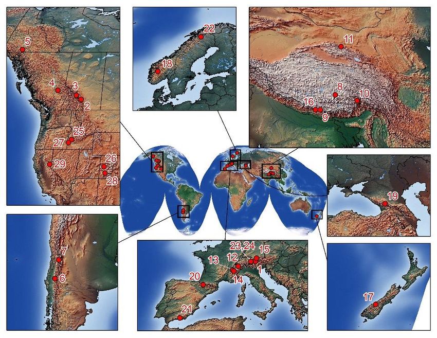
The mountain research sites have been and will continue to be core to INARCH. These are listed below
and shown in Fig. 1.
Austria 1. Rofental Open Air
Laboratory (OpAL);
Canada 2. Marmot Creek
Research Basin; 3. Peyto
Glacier; 4. Quesnel River
Research Basin; 5. Wolf Creek
Research Basin;
Chile 6. Upper
Diguillín; 7. Upper Maipo;
China 8. Nam Co Monitoring
and Research Station for
Multisphere
Interactions; 9. Qomolangma
Atmospheric and
Environmental Observation
and Research
Station; 10. Southeast Tibet
Observation and Research
Station for the Alpine
Environment; 11. Upper Heihe Figure 1. Current Integrated High Mountain Observing and
River Basin; Predicting Systems (IHMOPS) in INARCH
France 12. Arve
Catchement; 13. Col de Porte Experimental Site; 14. Col du Lac Blanc Experimental Site;
Germany 15. Schneefernerhaus and Research Catchment;
Nepal 16. Langtang Catchment;
New Zealand 17. Brewster Glacier;
Norway 18. Finse Alpine Research Centre;
Russia 19. Djankuat Research Basin;
Spain 20. Izas Research Basin; 21. Guadalfeo Monitoring Network;
Sweden 22. Tarfala Research Catchment;
Switzerland 23. Dischma Research Catchment; 24. Weissfluhjoch Snow Study Site;
United States of America 25. Dry Creek Experimental Watershed; 26. Grand Mesa Study
Site; 27. Reynolds Creek Experimental Watershed; 28. Senator Beck Basin Study Area; 29. Sagehen
Creek, Sierra Nevada.
7As we move towards models that include explicit representation of physical processes at a higher
resolution over larger domains, the question is what are the insights, lessons, information that can be
useful from the research catchments feeding into these large-scale projects? What would be meaningful
from this group? Notwithstanding the availability of high-resolution and broad spatial coverage of
remotely sensed observations, the experimental data that reveals insight on process understanding is still
crucial. Improved computational capacity is helping to bridge scales, but this does not replace the need
for high quality; there is a need to ensure that the models follow trusted observations and this is necessary
to improve the models. We will take some of the well-instrumented INARCH sites and begin to apply the
spatial models together to better understand their differences, what the models do and what they
include, and how they might evolve together. The future is likely model-agnostic (e.g., there are many
models, often incorporating the same process algorithms) and so looking at these together we can better
understand how they operate. Comparing model routines at different sites under a common framework
will be useful and worthwhile.
INARCH will use the mountain observatory sites towards many of our science questions. We will explore
coupling remote sensing datasets with mountain observatory data, developing and/or utilizing more
computationally intensive spatial data assimilation procedures to run on these sophisticated model
frameworks, and evaluating and incorporating improved remote sensing datasets. There is need for
improved data assimilation in a more “spatially aware” framework e.g., when dealing with mass transfer
between grid cells or computational units—especially critical for the snow community. Operational
methods for forecasting are called for by society and these will include forecasting systems that are aided
by data assimilation.
Collaboration Mechanisms
INARCH will continue to follow the same collaboration mechanisms as it has in past. This includes focused
workshops to promote scientific integration, joint field and modelling experiments, joint development of
open-access modelling and downscaling tools, promoting development of other alpine catchments,
climate change sensitivity experiments, and model and process algorithm evaluation and
intercomparisons. INARCH will contribute to UNESCO Intergovernmental Hydrological Programme efforts
on climate change impacts on snow, glacier and water resources within the framework IHP-IX (2022–
2029), “Science for a Water Secure World in a Changing Environment”, and we will contribute to the WMO
High Mountain Summit call for action, in particular, the observation and prediction aspects of the
Integrated High Mountain Observation, Prediction and Services Initiative. It will be imperative for INARCH
to show leadership and provide guidance for governments to implement this.
New ideas emerged at our recent online workshop. INARCH will plan to carry out a period focusing on
obtaining high-quality measurements to the extent possible, defining this as starting in 2022 to coincide
with the start of the snow season in the southern hemisphere, and carrying on until 2024. During this
common observing period experiment (COPE) we would ensure sensors are all working, fly supplementary
UAV acquisitions, and work together for comparison of processes, data sharing, and model testing in
challenging environments. The COPE will be enhanced with a suite of new and low-cost and more
advanced sensors and drones to build and deploy at multiple sites to directly compare observations and
gather a common data set (both instrument and site comparisons). Other sensors that are common across
multiple sites (more expensive commercially available sensors) could also be compared. This will expand
spatial coverage and allow broader participation, while more advanced technologies can be shared and
deployed across sites. A working group will be formed to guide this initiative.
8INARCH has advanced despite COVID-19, but we have new ideas that need deep discussion, and need to
reconvene in person at an alpine research site in 2022. We plan to hold the next in-person workshop in
Benasque, Spain, where detailed preparations were made for the meeting in March 2020 that was
cancelled due to COVID-19. We must include hybrid options for virtual participation as well. For future
meetings, we should consider the carbon footprint of travel and try, to the extent possible, to take
advantage of other major meetings or events where travel is already occurring. Meeting in Asia would be
desirable at some point in the future.
9You can also read