THE KRAKATAU VOLCANO 125 YEARS AFTER THE CATASTROPHIC ERUPTION (AUGUST 27, 1883)
←
→
Page content transcription
If your browser does not render page correctly, please read the page content below
NON-REVIEWED CONTRIBUTION

THE KRAKATAU VOLCANO 125 YEARS
AFTER THE CATASTROPHIC ERUPTION (AUGUST 27, 1883)

A. ŠPIČÁK, J. KOZÁK, J. VANĚK AND V. HANUŠ

Institute of Geophysics, Acad. Sci. Czech Republic, Boční II/1401, 141 31 Praha 4, Czech Republic
(als@ig.cas.cz)

    The Krakatau volcano (latitude 6.10°S, longitude 105.42°E; often misstated as
Krakatoa) is situated in the Sunda Strait between Sumatra and Java (Figs. 1 and 2). Its
1883 eruption, the second largest in Indonesia during historical time (Venzke et al., 2002),
belongs to the most often commemorated natural events in the history of mankind. The
eruption was not the only documented manifestation of eruptive potential of the Krakatau
volcano in the past. The first historically documented strong explosion occurred in
416 A.D. (Venzke, 2002). More than a century later, the year 535 A.D. marks the worst
climactic conditions of the last 1600 years - a finding based on tree-ring and ice-core data
(Wohletz, 2000). Proposed causes of this climactic downturn include a catastrophic
eruption of Krakatau volcano (Keys, 1999) or a bolide impact near the same location. The
event is supposed to be responsible for subsequent climate destabilization all over the
world, lasting years or perhaps several decades. Another destroying event occurred in the
region of the nowadays Sunda Strait in 1115 (Boscowitz, 1890). Then, a disastrous
earthquake allegedly destroyed an isthmus connecting Sumatra and Java by that time.
Later, strong eruptions of Krakatau occurred in 1680 and 1684 (Venzke et al., 2002).
    The 1883 Krakatau eruption ejected more than 25 cubic kilometers of rock, ash and
pumice, generated the loudest sound historically reported, heard as far away as 5 000 km,
and destroyed two-thirds of the island of Krakatau (Fig. 3). Number of casualties in the
Sunda Strait and in its vicinity was assessed between 35 and 70 thousand. Giant sea waves
reached height of up to 40 meters and propagated through the Indian Ocean and the South
Atlantic Ocean, as plotted in the map by Hermann Berghaus (1888), the part of which is
reproduced in Fig. 4. Already this map, published 116 years before the damaging tsunami
following the 2004 Sumatra-Andaman earthquake, pointed to a deadly potential of
tsunami generated in Indonesia to the coast of the Bay of Bengal and Indian Ocean. An
eye-witness on board of a vessel with refugees trying to escape from the endangered town
of Telong Betong on the Sumatran side of the Sunda Strait described his experience with
the following words: “We saw a gigantic wave of prodigious height suddenly advancing
upon us at great speed from the direction of the open sea. Immediately, the captain
brought his vessel round so as to meet the wave stem foremost. After a moment of
poignant anxiety, we found ourselves lifted up with terrific speed; our vessel bounded
upward, and then we felt ourselves again plunged into the abyss. But the wave had passed
us, and we were out of all danger. Like a high mountain, the gigantic wave sped furiously
towards the shore while, immediately after, three other great waves followed it. Thus we
had before our eyes the terrible spectacle of the waters rushing in and destroying the
town, sweeping away first the lighthouse, which fell in like a pack of cards, then all the
buildings beyond. In a few moments all was over, and where once Telok-Betong stood
there was soon nothing but water” (Boscowitz, 1890).

Stud. Geophys. Geod., 52 (2008), 449−454                                                    449
© 2008 Inst. Geophys. AS CR, Prague
NON-REVIEWED CONTRIBUTION

Fig. 1. Regional geographical maps of Java and Indonesia (Leonhard, 1844); position of the
Sunda Strait denoted by circle, the Krakatau volcano by triangle.

Fig. 2. Krakatau volcano after the 1883 catastrophic eruption (Kraemer, 1902−1904 after
Verbeek, 1986).

450                                                            Stud. Geophys. Geod., 52 (2008)
NON-REVIEWED CONTRIBUTION
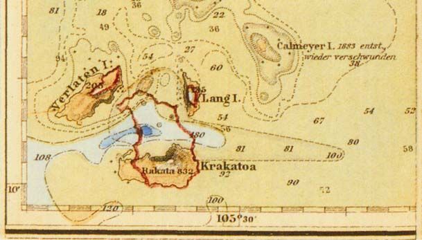
Fig. 3. Map of islands in the Sunda Strait after the 1883 eruption (Berghaus, 1888). Coastline
before the 1883 eruption denoted by the red line.
In 1927, the post-collapse cone of Anak Krakatau (Child of Krakatau) emerged from
the sea within the 1883 caldera. Since then, the volcanic activity of Krakatau is almost
permanent, but mostly mild, enabling numerous tourists to admire the volcano closely.
Only eruptions in 1932 and 1938 were stronger (VEI 3).
Since 2005, the Sunda Strait and the Krakatau volcano dynamics has been monitored
by the KrakMon (Krakatau Monitoring) project, a joint initiative of the Indonesian Centre
of Volcanology and Geological Hazard Mitigation (CVGHM) and the German
Bundesanstalt für Geowissenschaften und Rohstoffe (BGR) (http://krakmon.vsi.
esdm.go.id/).
In 2002, the paper by Špičák et al. (2002) was published on numerous occurrences of
strong (mb between 4 and 6), teleseismically recorded earthquakes beneath the volcano
during the last 40 years (1964−2005), reaching depths from shallow down to 100 km
Stud. Geophys. Geod., 52 (2008) 451NON-REVIEWED CONTRIBUTION Fig. 4. Isolines expressing propagation velocity of tsunami generated by the 1883 Krakatau eruption in the Indian Ocean and South Atlantic Ocean (Berghaus, 1888). The time interval between two neighbouring isolines is 1 hour. Coast of India was reached by tsunami in 6 hours, coast of Madagaskar in 9 hours and eastern coast of southernmost South America in 17 hours. (Fig. 5). Such earthquakes probably express recent dynamics of the plumbing system of the Krakatau volcano. The continuous occurrence of the earthquakes in time (instead of episodic swarms and/or aftershock sequences) seems to reflect a steady magma transport to the Earth’s surface. Focal depths of earthquakes constrain the location of the primary magma generation to greater depths, to the subducting slab of the Indo-Australian plate. Recent strong earthquake occurrence beneath the Krakatau volcano is unique among the subduction-related volcanoes. 452 Stud. Geophys. Geod., 52 (2008)
NON-REVIEWED CONTRIBUTION

Fig. 5. Time plot of strong earthquake occurrences beneath the Krakatau volcano (73 earthquakes
are denoted according to their body wave magnitude, mb) and its eruptive history (expressed by the
volcanic explosivity index, VEI*) in the modern period 1964−2005. Eruptive history taken from
Venzke et al. (2002), earthquake hypocentre parameters from Engdahl et al., (1998).
* VEI - Volcanic Explosivity Index, a measure of the magnitude and energy of volcanic eruptions based on
several basic parameters - eruption duration and style, volume of eruptive products, and the eruption column
height. The scale is open-ended with the largest volcanoes in history given magnitude 8. Each interval on the
scale represents a tenfold increase in observed eruption. VEI 1 - Stromboli; VEI 4 - Sufrière Hills, Montserat,
1995, ejecta volume > 0.1 km3; VEI 5 - St. Helens, USA, 1980, ejecta volume > 1 km3; VEI 6 - Krakatau,
Indonesia, 1883, ejecta volume > 10 km3; VEI 7 - Tambora, Indonesia, 1815, ejecta volume > 100 km3; VEI 8 -
Toba, Sumatra, Indonesia, 73 000 B.P., ejecta volume > 1 000 km3 (Sigurdsson, 2000).

    Acknowledgements: The authors are grateful to our colleague M. Švamberková for technical
help in preparation of this paper.

                                                 References
Berghaus H., 1888. Physikalischer Atlas. J. Perthes, Gotha.
Boscowitz A., 1890. Earthquakes. G. Routledge, London.

Stud. Geophys. Geod., 52 (2008)                                                                          453
NON-REVIEWED CONTRIBUTION
Engdahl E.R., van der Hilst R.D. and Buland R., 1998. Global teleseismic earthquake relocation
with improved travel times and procedures for depth determination. Bull. Seismol. Soc. Amer.,
88, 722−743.
Keys D., 1999. Catastrophe. An Investigation into Origins of the Modern World. Arrow, London.
Kraemer H. (Ed.), 1902−04. Weltall und Menschheit. Geschichte der Erforschung der Natur und
der Verwendung der Naturkräfte im Dienste der Völker. 1er Band, Berlin.
Leonhard K.C., 1844. Vulkanen - Atlas zur Naturgeschichte der Erde. F. Schweizerbart, Stuttgart.
Sigurdsson H. (Ed.), 2000. Encyclopedia of Volcanoes. Academic Press, San Diego.
Špičák A., Hanuš V. and Vaněk J., 2002. Seismic activity around and under Krakatau volcano,
Sunda Arc: constraints to the source region of island arc volcanics. Stud. Geophys. Geod., 46,
545−565.
Venzke E., Wunderman R.W., McClelland L., Simkin T., Luhr J.F., Siebert L. and Mayberry G.
(Eds.), 2002. Global Volcanism, 1968 to the Present. Smithsonian Institution, Global
Volcanism Program Digital Information Series, GVP-4 (http://www.volcano.si.edu/reports/).
Verbeek R.D.M, 1884. Krakatau Album. Nationaal Aardrijkskundig Instituut, Batavia.
Wohletz K., 2000. Were the dark ages triggered by volcano-related climate changes in the 6th
century? EOS, Trans. Amer. Geophys. Union, 48 (81), F1305; http://www.ees1.lanl.gov
/Wohletz/Krakatau.htm.
454 Stud. Geophys. Geod., 52 (2008)You can also read