THE MOTU KAIKOURA TRUST 2020 - MOTU KAIKOURA SCENIC RESERVE MANAGEMENT PLAN
←
→
Page content transcription
If your browser does not render page correctly, please read the page content below
MOTU KAIKOURA SCENIC RESERVE
      MANAGEMENT PLAN

                                         Neil Davies
         Motu Kaikoura Trust 2017

                                    Neil Davies

THE MOTU KAIKOURA TRUST 2020
         www.motukaikoura.org.nz
Table of Contents
A. MOTU KAIKOURA - THE VISION .................................................................................................................................................... 4
    Administration of Motu Kaikoura Scenic Reserve ............................................................................................................................. 5
B. THE LANDSCAPE AND GEOLOGY ................................................................................................................................................ 6
C. THE NATURAL ENVIRONMENT .................................................................................................................................................... 8
    C.1 Motu Kaikoura Biodiversity Management Plan ........................................................................................................................... 8
    C.2 Flora .......................................................................................................................................................................................... 8
    C.3 Fauna ...................................................................................................................................................................................... 11
    C.4 Pest Management and Biosecurity ........................................................................................................................................... 16
D. HISTORICAL AND CULTURAL HERITAGE ................................................................................................................................... 22
E. PUBLIC ACCESS, INFRASTRUCTURE AND ASSETS ................................................................................................................. 30
    E.1 Overall objectives for the management of public access, infrastructure and assets ................................................................. 30
    E.2 Jetty, pontoons, moorings and roads ....................................................................................................................................... 30
    E.3 Motu Kaikoura airfield .............................................................................................................................................................. 31
    E.4 Accommodation and buildings.................................................................................................................................................. 35
    E.5 Walking track network .............................................................................................................................................................. 37
    E.6 Telecommunications facilities ................................................................................................................................................... 39
F. OUTDOOR EDUCATION AND RECREATION ............................................................................................................................... 40
G. SUSTAINABLE MANAGEMENT AND PUBLIC HEALTH AND SAFETY ........................................................................................ 42
H. CONCESSIONS ............................................................................................................................................................................. 43
References.......................................................................................................................................................................................... 47
APPENDIX 1 Acquisition of Motu Kaikoura into public ownership and the establishment of the Motu Kaikoura Trust ........................ 49
APPENDIX 2 Heads of Agreement between the Minister of Conservation and the Motu Kaikoura Trust Board. ................................. 52
APPENDIX 3 Botanical Survey ........................................................................................................................................................... 57
APPENDIX 4 Baseline Bird Survey Report ......................................................................................................................................... 67
APPENDIX 5 Motu Kaikoura Archaelogical Survey ............................................................................................................................. 80
APPENDIX 6 World War 2 Defence of Great Barrier........................................................................................................................... 84
APPENDIX 7 Reserves Act 1977 s19 ................................................................................................................................................. 87

FIG. 2: MOTU KAIKOURA (Andris Apse – Nature Heritage Fund)

                                                                                                                                                                                                       2
FIG. 3: GREAT BARRIER ISLAND PORTS AND ANCHORAGES SURVEYED BY CAPTAIN J.L. STOKES
AND THE OFFICERS OF H.M.S. ACHERON, 1849 (N.Z. MAP NO. 3914, CLASSIFICATION D, 995.135aj).

(Source: Special Collections, Auckland City Libraries, N.Z.; Ref. 2007-91)

                                                                                             3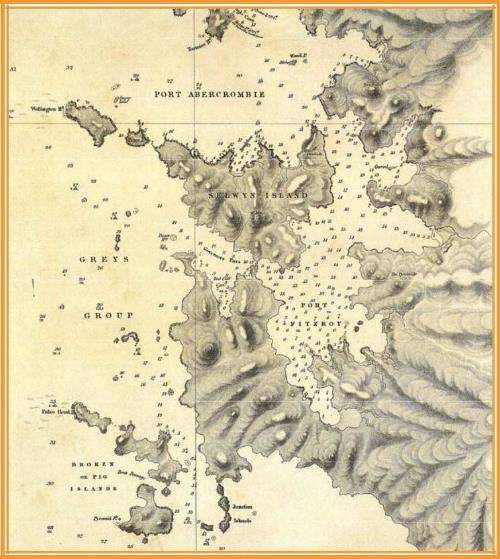
A. MOTU KAIKOURA - THE VISION
      Motu Kaikoura was purchased into public ownership by the government in
   2004 after a 10-year campaign supported by the people of the Auckland region,
   with funds from the Nature Heritage Fund and significant additional financial
   contributions from the former ASB Community Trust (Foundation North), Auckland
   Regional Council, Auckland City Council, and other territorial local authorities.
   Motu Kaikoura is a gazetted scenic reserve under the Reserves Act 1977 and
   vested in the Crown. The Motu Kaikoura Trust Board was appointed to control and
   manage the reserve under Section 29 of the Act, subject to the Heads of
   Agreement between the Minister of Conservation and the Trust. Also refer to
   Appendix 1 Acquisition of Motu Kaikoura into public ownership and the
   establishment of the Motu Kaikoura Trust.

   Motu Kaikoura is valued for its scenic qualities and landscape and that it offers
   respite to visitors in a quiet natural setting that is relatively free of development. It
   has an interesting Māori and European history. Above all Motu Kaikoura is an
   island with significant potential for conservation purposes and can contribute to
   New Zealand’s need for more secure sanctuaries for native wildlife. The
   management objective of the island is to the restore the viability of its natural
   ecosystems through natural regeneration of the native biodiversity, free of invasive
   plants and animals.
   The Trust will work in collaboration with the Department of Conservation, Auckland
   Council and Ngāti Rehua to achieve the following vision:

   MOTU KAIKOURA – THE VISION
    A publicly owned environmentally restored island sanctuary with
    healthy eco-systems and flourishing native flora and fauna, and
       protected cultural heritage sites, which promotes outdoors
        recreation and education, in the Hauraki Gulf Marine Park
   The objectives for the management of Motu Kaikoura are:
   1. To protect and enhance the values of Motu Kaikoura, the scenic qualities,
      natural beauty and landscape
   2. To encourage and facilitate public access to the island
   3. To sustainably manage the amenities and facilities of the island
   4. To manage and protect the historic, archaeological, geological, biological and
      other scientific features present on the island.
   5. To conserve the soil, water and forest on the island.

   To achieve the Vision and Objectives the Motu Kaikoura Trust will:
   6. Work towards managing animal pest and plant pest species to zero density
   7. Restore the island’s indigenous flora and fauna, and damaged and disrupted
      ecological processes, while encouraging public and community participation in
      ecological regeneration activities and encouraging tertiary institutions and
      research agencies to undertake scientific research on Motu Kaikoura.

                                                                                               4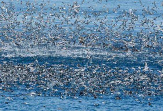
8. The Motu Kaikoura Trust will work with Ngāti Rehua – Ngāti Wai ki Aotea to
   recognise and protect in particular features and archaeological sites of historic
   and cultural importance to manawhenua.

9. The Motu Kaikoura Trust will enable a first-class outdoor recreation experience
   for all visitors by:
   • maintaining walking tracks, interpretive signage, buildings,
       accommodation and all infrastructure
   • encouraging outdoor education for young people in particular
   • maintaining good relationships with neighbouring landowners, the
       Great Barrier community and the Great Barrier Island Local Board.

                                       Notice
The policies of this Management Plan are based on the provisions of the Heads of
Agreement between the Minister of Conservation and the Motu Kaikoura Trust Board
signed on 28 April 2008 (see Appendix 2). The ecological restoration objectives and
chapters relating to conservation management should be read in conjunction with the
Motu Kaikoura Biodiversity Management Plan.

The Plan sets out the objectives and policies designed to achieve the above vision for
a range of management actions. The objectives express the intention or outcome
sought and are designed to assist explain the aim of the policies. The objectives also
provide a framework for the consideration and will be used in any situation where
discretion is necessary. The policies are designed to be more directive where certainty
of the outcome or the role of the agency identified in the policy is necessary. In most
cases the Trust will be the responsible agent unless otherwise stated. The Trust is a
voluntary agency with limited resources and all policies are therefore subject to the
caveat ‘as resources allow’.

Administration of Motu Kaikoura Scenic Reserve

Motu Kaikoura is a held as a Scenic Reserve in terms of Section 19(1)(a) of the Reserves
Act 1977 (refer to Appendix 7). These reserves are established to protect and preserve in
perpetuity, for their intrinsic worth and for the public benefit, enjoyment and use, such
qualities of scenic interest or beauty or natural features worthy of protection in the public
interest.

The Motu Kaikoura Trust Board (the Trust) was appointed as the administering body to
control and manage the reserve under Section 29 of the Act, subject to the Heads of
Agreement (refer to Appendix 2) between the Minister of Conservation and the Trust and
subject to the special condition that the reserve is to be available for
outdoor/environmental education for youth in particular and for provision of facilities to
achieve this.

The Heads of Agreement empowers the Trust to;
 • Prepare and administer a management plan under Section 41 of the Reserves Act
    1977.
 • Encourage and facilitate public access to the island, particularly by youth undertaking
    outdoor and environmental education.

                                                                                                5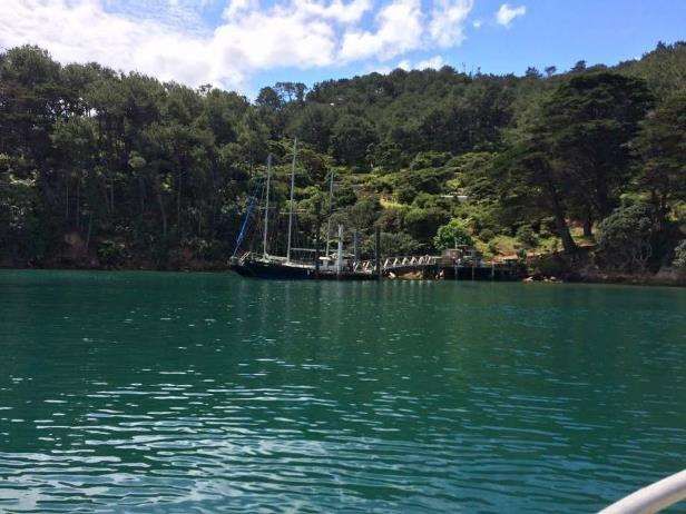
•   Preserve and protect the native flora and fauna.
 •   Work towards the eradication of pest animal such as deer and rats.
 •   Prepare a schedule of archaeological remains and geological features.
 •   Maintain and manage the structure and buildings, including the airfield, the wharf,
     moorings and pontoons. The Trust must gain the Department of Conservation’s prior
     approval for any new buildings or structures.
 •   Prepare a health and safety plan, ensure there are no fire hazards and maintain
     insurance policies against public and regulatory liabilities that may arise from
     managing the island.
 •   Comply with any regulatory or statutory requirements, such as building consents.

The Heads of Agreement enables the Department of Conservation to provide advice,
guidance and technical assistance to the Trust. This includes assisting the Trust in the
promulgation of bylaws and making available the rentals for the cellphone tower facilities
for the maintenance of the island including the wharf, moorings and pontoons.

The Trust also works in collaboration with other organisations. These include;
 • The Auckland Council on biosecurity matters, such as pest animal and plant control.
 • Ngāti Rehua – Ngāti Wai ki Aotea and its Hapū Management Plan on matters such
    as the cultural heritage of Motu Kaikoura
 • Conservation groups
 • Outdoor recreation and education groups
 • Science and research bodies
 • Reserve users and concessionaires

Motu Kaikoura is in the Hauraki Gulf, and the Hauraki Gulf Marine Park Act 2000 applies.

B. THE LANDSCAPE AND GEOLOGY
Motu Kaikoura (564.13 ha), (36°10’41”S, 175°19’28”E) is located 90 km northeast of
Auckland. It lies off the western coast of Great Barrier Island (Aotea) (28,500 ha), helping
form the harbour of Port Fitzroy.

The island’s topography varies from rolling to rugged grades with prominent ridges
and spurs and essentially no naturally flat land. The highest point, Kohatu Titore
(Mitre Peak) is 184 m high. The central, northwest-northeast oriented divide has
prominent andesitic tufts and rocky outcroppings. The region south of the divide
contains ridges and valleys covered with relatively fertile soil and clad with remnants
of mature podocarp and broadleaf forests and extensive areas of tea tree and
occasional wilding pines. In places the soils have been eroded primarily by past
overgrazing to reveal clay and/or rocky pans almost completely lacking in vegetation.

The island has a coastline of steep cliffs of varying height, with pohutukawa growing over
cliff faces having exposed volcanic agglomerates. There are a few perennial streams
occurring as small summer flows in the larger catchments. A sandy beach exists at
Bradshaw Cove on the northern shore.

The central wing-shaped, northwest-northeast divide has prominent rocky escarpments
and outcrops, including Kohatu Titore all andesitic remains of an ancient stratovolcano.

                                                                                               6
FIG 4: Location of Motu Kaikoura off Port Fitzroy, Great Barrier Island.

Geologically, the island was formed during the Pliocene and Miocene epochs from strato-
volcanic eruptions that resulted in poorly sorted andesitic breccias, tuffs and agglomerates
(Figs. 4 & 7). The present-day soils are predominantly FitzRoy Hill soils mixed with Barrier
Steep Land soils, rocky clay loam and clay loam. Smaller areas of FitzRoy clay loam and
bouldery clay loam occur on the central ridge, farm gully and spurs of the northern
coastline.

FIG: 5: Motu Kaikoura’s southern volcanic coast line just west of the Man-of-War Passage (Governor’s Pass). The
volcanic origins of the island are evident from the globular agglomerates present in the cliff face along the shoreline.
(A. Bellvé)

                                                                                                                           7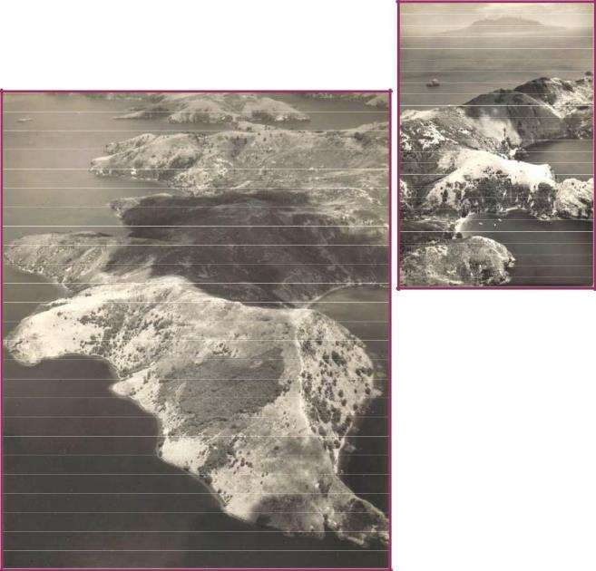
C.     THE NATURAL ENVIRONMENT

C.1    Motu Kaikoura Biodiversity Management Plan

The Motu Kaikoura Biodiversity Management Plan (https://www.motukaikoura.org.nz) is a
‘how to’ document that details the methods and timeframes of different tasks that will work
towards achieving the objectives and overall vision for the Island that is detailed below.
These recommendations and tasks have taken into account the previous actions and
successes of the management of Motu Kaikoura thus far. While the Plan covers a period
of 10 years, where appropriate some recommendations give consideration to timeframes
beyond this scope.

Since the formation of the Motu Kaikoura Trust a major effort has taken place to rid the
island of exotic mammals and rats. Fallow deer, pigs, cats and rabbits were eradicated in
the period up to and including 2008. After an unsuccessful attempt in 2008 to eradicate
rats by means of an aerial operation, rats are being routinely managed at or around 5%
relative index during the late winter, spring – early summer. This has resulted in
accelerated natural regeneration of flora and fauna.

C.2    Flora

As indicated the island’s native forest cover is rapidly regenerating following the
eradication of fallow deer in 2009 and commencement of island-wide rodent control in
2014.

C.2.1 Kanuka woodlands

Extensive areas of tall kanuka, especially on the southern, western slopes and northern
slopes of the island, form the predominant vegetation. The under storey is regenerating
led by deer-browse resistant species, e.g. Coprosma rhamnoides, Lepidosperma laterale,
trunkless ponga (Cyathea dealbata), locally Olearia furfuracea, and Microlaena stipoides
swards as ground cover. Parsonsia (Parsonsia capsularis), the main vine, often forms
tangles on the ground, and bush lawyer (Rubus cissoides) is common locally.

C.2.2 Broadleaf forest

Extensive coastal broadleaf forest occurs in the southwest region of the island (S08
191548), extending c.300m along the coast and c.300m inland. The canopy is 12-15m tall
and dominated by taraire (Beilschmeidia tarairi) with trunk diameters of 25-15 cm. Other
canopy trees include the occasional puriri (Vitex lucens) with trunks to 1-m diameter,
kohekohe (Dysoxylum spectabile), tawaroa (Beilschmiedia tawaroa), pohutukawa
(Metrosideros excelsa), karaka (Corynocarpus laevigatus), a few tawapou (Pouteria
costata) near the coast, hinau (Elaeocarpus dentatus) at least four trees away from the
coast, mamaku (Cyathea medullaris) with mainly dead standing trunks, miro at least two
trees away, wharangi (Melicope ternata) near the coast; and individual trees of mahoe
(Melicytus ramiflorus), coastal maire (Nestegis apetala), rewarewa (Knightia excelsa), and
lacebark (Hoheria populnea). Tall kanuka occurs on the forest margins with an under
storey of ponga. Climbers present include: parsonsia, (Metrosideros perforata) (mainly
along the ground), supplejack (Ripogonum scandens) in small patches, bush lawyer and a
single native passionfruit (Passiflora tetrandra). A particular feature of this area is the
diminutive and rare saprophytic orchid (Danhatchia australis).

Epiphytes are not common; the main one, (Collospermum hastatum), occurs in occasional
clumps, and there are several fern species. Understory and ground cover plants are now
                                                                                              8
flourishing; large rocks are common. Locally there are seedlings of kohekohe and mapou
(Myrsine australis), tiny kawakawa (Macropiper excelsum) (
C.2.6 Stream margins/wetland plants

The main perennial streams are at Bradshaw Cove, Houseboat Bay and the valley west of
Crawford’s Bay. Also, three valleys on the southwest coast had small flows that
disappeared into coastal sands. Damp areas are present at the head of most bays along
the southern coast, and locally mats of Ranunculus acaulis were present with koromiko
(Hebe pubescens), hangehange (Geniostoma ligustrifolium).

The largest wetland was part of the stream below Top House, which included a pond area
formed by an earthen dam. The pond is dominated by Potomogeton cheesemanii,
Persicaria decipiens and Eleocharis acuta. Locally, around the margins, there is swamp
millet (Isachne globosa), Carex virgata and various rushes (Juncus spp.). Upstream of the
pond under a manuka canopy (c.3m tall) the ferns (Diplazium australe) and (Adiantum
aethiopicum) dominate the valley bottom. The Trust will continue to support botanical
surveys and vegetation monitoring including monitoring for lichen and will maintain
farmhouse orchard for specific lichen.

 C.2.7 Objectives for native flora management

 1. To restore the role of the native forests in a healthy functioning ecosystem
 2. To preserve and protect the native flora
 3. To facilitate the regeneration of the native flora
 4. To manage the threats to native fauna, such as animal and plant pests and
    adverse disturbances to their habitats by human activity and development
 5. To conserve the soil, water and forest.

 C.2.8 Policies for native flora management

 1. Continue the monitoring of flora and report periodically as set out in the Motu
    Kaikoura Biodiversity Management Plan
 2. Progressively remove all pest plants in accordance with C.4.3 Policies
 3. Use a non-interventionist approach to the regeneration of native flora subject to
    C.3.4 Policy 5 with respect to the establishment of flax as a nectar source
 4. Evaluate the status of all nationally threatened vascular plant species on the
    island to see if any require specific management other than continued pest
    animal and plant management.

                                                                                            10
C.3 Fauna
C.3.1 Forest birds
Birds have been surveyed annually since 2006 (Galbraith and Jones 2010). The current
record is 41 bird species on the island, of which 29 species are indigenous and 12 are
exotic.
Refer to Appendix 4. Baseline Bird Survey Report. With the significant decrease in rats
through ongoing control there are indications of increased numbers of birds on the island.
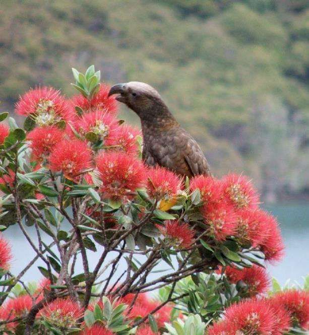
Kaka (Nestor meridionalis) are locally common on Motu Kaikoura. The southeastern pine
block cones appear to be an important food source. Pines on the island, particularly P.
pinaster also provide a food source for kaka and their removal should be progressively
staged over a period of time. Kereru (Hemiphaga novaeseelandiae) and tui
(Prosthemadera novaeseelandiae) are present in increasing numbers and banded rails
(Gallirallus phillippensis) are locally common, especially noticeable around the settlement.
Kingfisher (Todiramphus sanctus) and morepork (Ninox novaeseelandiae). Brown teal
(Anas aucklandica) have recently been recorded breeding on the island. There are
occasional reports of bellbirds (Anthornis melanura) and red-crowned parakeets
(Cyanoramphus novaezelandiae), and in 2016 a long-tailed cuckoo (Eudynamys taitensis)
was seen.
C.3.2 Seabirds
The Hauraki Gulf is a particularly rich area for seabirds and considered a global ‘hot spot’
with 25 breeding species, including a number of threatened species. Seabirds are known
to enrich terrestrial systems through the transportation of marine nutrients and borrowing
in soil and can be the ecological ‘drivers’ of terrestrial communities on islands. It is highly
likely that, historically, Motu Kaikoura would have supported large populations of seabirds.
Although seabirds are present in the waters surrounding the island, no burrow-nesting
species are known to be present at this point. Cook’s petrels (Pterodroma cookii) have
been sighted over- flying the island and a carcass of this species was found in Bradshaw
Valley in November 2014. The principal breeding area for Black petrels (Procellaria
parkinsoni) is on Great Barrier, with nesting sites recorded as close as 2 km away from
Motu Kaikoura in the Glenfern Sanctuary. The blue penguin (Eudyptula minor), was once
very common breeding along Great Barrier’s rocky coastline, nests on Motu Kaikoura.
There is also regionally significant breeding colony of pied shag (Phalacrocorax varius) on
the island’s southern side. Many of the smaller islands and stacks i.e. The Grey Group in
the vicinity of Motu Kaikoura still support small numbers of seabirds.
In terms of bird translocation, (see policy C.2.3), likely candidates listed should include
bush birds and other species recently extinct on Great Barrier and those given national
species recovery priorities as set out in the operative Motu Kaikoura Biodiversity
Management Plan (see https://www.motukaikoura.org.nz). Seabirds that nest on the
island are a potential source of nutrients for the island ecosystems. Burrowing seabirds
are considered soil ‘engineers’ and their importation and recycling of marine nutrients are
an essential element in restoring the health and function of island ecosystems. The role of
seabirds, burrowing petrel and shearwater species in particular, are now widely
recognised as crucial to any island ecosystem restoration plan. Consideration may
therefore be given to attracting seabirds to nest in appropriate locations on the island
through the use of audio attraction techniques. To discourage invasive weeds colonising
open areas such as new slip faces consideration will be given to sowing flax (Phormium
spp.) seeds in these areas. This will also provide a source of nectar for birds.
11Fig: 6: A work-up of seabirds off the nearby Mokohinau Islands (Chris Gaskin).
C.3.3 Objectives for the management of native birds
1. To restore the role of the native forests in a healthy functioning ecosystem
2. To preserve and protect the native birds
3. To preserve and protect the habitats for native birds
4. To manage the threats to native birds, such as animal and plant pests and adverse
disturbances to their habitats by human activity and development.
C.3.4 Policies for the management of native birds
1. Continue regular annual bird monitoring across a variety of habitats to track
changes in species presence and abundance on the island
2. Work towards the eradication of rodents from Motu Kaikoura with an initial goal of
achieving ≤5% relative abundance density with progress monitored quarterly with
independent monitoring undertaken every two years
3. For kaka, maintain mature P. pinaster until mature native canopy
species are established and are more widespread
4. Maintain a list of bird species for potential future translocation
5. Where appropriate sow flax (Phormium spp.) seeds in open areas to provide a
nectar source for birds and reptiles and to combat invasive weeds
6. Encourage seabird re-establishment by audio attraction techniques.
12C.3.5 Reptiles
Reptile surveys, assisted by the use of artificial cover objects (ACOs), have been
undertaken periodically from 2008 (Martin 2012). Cameron et al. (2007) recorded the
presence of moko skink (Oligosoma moco) as well as copper skink (Cyclodina aenea)
during a vegetation survey. Martin (2012) reports that moko skink and copper skink are
widespread throughout the island in forest and shrubland habitats, and shore skink
(Oligosoma smithi) are present on the boulder beach below Mount Overlook. Gecko
species have not yet been confirmed despite extensive searches under logs, rocks and
debris, and spotlighting within forest, shrubland, and coastal cliff habitats at night. Many
more species of reptile are likely to have been present on Motu Kaikoura prior to human
settlement. Forest gecko (Hoplodactylus granulatus), Pacific gecko (H. pacificus),
common gecko (H. maculatus), and Duvaucel’s gecko (H. duvaucelii) would all have been
present, along with ornate skink (C. ornata), striped skink (O. striatum), and egg- laying
skink (O.suteri). These species may all still be present, albeit in very low numbers.
Hochstetters frog (Leiopelma hochstetteri) has been located in streams on nearby
northern Great Barrier, Te Paparahi. Tuatara (Sphenodon punctatus) were formerly on
Great Barrier and may have been present on Motu Kaikoura. Mokohinau skink (O.townsi),
common green gecko (Naultinus elegans) and chevron skink (O. homalonatum) are still
present on Great Barrier and their possible presence on Motu Kaikoura cannot be ruled
out.
C.3.6 Objectives for the management of native reptiles
1. To restore the role of the native forests in a healthy functioning ecosystem
2. To preserve and protect the native reptiles
3. To preserve and protect the habitats for native reptiles
4. To manage the threats to native reptiles, such as animal and plant pests and
adverse disturbances to their habitats by human activity and development.
C.3.7 Policies for the management of native reptiles
1. Undertake monitoring of reptiles to track changes in species presence and
abundance on the island and periodically report as set out in the Motu Kaikoura
Biodiversity Management Plan.
2. No translocations will be considered for a minimum of 10 years (from 2012) to
allow remnant populations of species to be detected and expand naturally.
13C.3.8 Native Mammals – terrestrial and marine
Limited bat information is available for Motu Kaikoura as no formal surveys have yet been
undertaken. Long-tailed bats (Chalinolobus tuberculatus) are present on Great Barrier
Island and are good fliers. It is possible that long-tailed bats are periodic visitors to the
island and the rapidly regenerating forest is likely to provide suitable habitat.
The outer Hauraki Gulf, including around Great Barrier Island, is recognised as an
important nursery area for marine mammals, such as the common dolphin (Delphinus
delphis) and the bottle-nosed dolphin (Tursiops truncatus). Research on habitat utilisation,
abundance and density of these dolphins is being undertaken by Massey University using
Motu Kaikoura as a base.
C.3.9 Objectives for the management of native mammals
1. To restore the role of the native forests in a healthy functioning ecosystem
2. To preserve and protect the native mammals
3. To preserve and protect the habitats for native mammals
4. To manage the threats to native mammals, such as animal and plant pests and
adverse disturbances to their habitats by human activity and development.
C.3.10 Policies for the management of native mammals
1. Undertake monitoring for bats to identify if they are present on the island
2. Support research of the status of suitable food species for bats in the future once
natural regeneration of coastal forest species has occurred
3. Encourage the present use of Motu Kaikoura as an important base for marine
mammal research.
C.3.11 Freshwater fauna
The following freshwater fish species are known to live on Great Barrier Island:
• longfin eel (Anguilla dieffenbachia)
• shortfin eel (A. australis)
• inanga (Galaxias maculatus)
• banded kokopu (G. fasciatus)
• giant kokopu (G. argenteus)
• redfin bully (Gobiomorphus huttoni)
• giant bully (G. gobioides)
• common bully (G. cotidianus)
• bluegill bully (G. hubbsi)
• cockabully (Grahamina nigripenne)
• freshwater crayfish, kōura (Paranephrops planifrons)
It is likely that some of these species, such as longfin eel, short fin eel, banded kokopu,
and common bully are present on Motu Kaikoura. Fortunately, Great Barrier Island (and
therefore, it is assumed, Motu Kaikoura) is free of invasive freshwater pest fish.
14C.3.12 Objectives for the management of native freshwater fauna
1. To restore the role of the native forests and waterways in a healthy functioning
ecosystem
2. To preserve and protect the native freshwater fauna
3. To preserve and protect the habitats for native freshwater fauna
4. To manage the threats to native freshwater fauna, such as animal and plant pests
and adverse disturbances to their habitats by human activity and development.
C.3.13 Policies for the management of native freshwater fauna
1. Support the collection of baseline data for freshwater fauna and report periodically
as set out in the Motu Kaikoura Biodiversity Management Plan
2. Prevent the introduction of invasive freshwater pest fish into the Motu
Kaikoura freshwater ecosystem.
C.3.14 Invertebrates
A single individual of the Great Barrier paua slug (Schizoglosaa novoseelandica) was noted
by Cameron (2007) in the taraire forest on the south-west coast. Further surveys of
terrestrial invertebrates and invertebrates need to be completed. A number of weta boxes
have been set up on some track lines to provide baseline data for weta numbers.
C.3.15 Objectives for the management of native invertebrates
1. To restore the role of the native forests and waterways in a healthy
functioning ecosystem
2. To preserve and protect the native invertebrates
3. To preserve and protect the habitats for native invertebrates
4. To manage the threats to native invertebrates, such as animal and plant
pests and adverse disturbances to their habitats by human activity and
development.
C.3.16 Policies for the management of native invertebrates
1. Continue annual weta surveys and report periodically as set out in the Motu
Kaikoura Biodiversity Management Plan
2. Support the collection of baseline data for invertebrates and report periodically as
set out in the Motu Kaikoura Biodiversity Management Plan.
15C.4 Pest Management and Biosecurity
C.4.1 Pest plants
Pest plants present on the island originate from previous farm gardens, the presence of
livestock, wind dispersed seed from Great Barrier or from being attached to or within
birds. Fortunately the lack of habitat on the island means that many weeds present on
Great Barrier are absent from Motu Kaikoura, such as wandering Jew (Tradescantia
fluminensis), sweet pea shrub (Polygala myrtifolia), kahili ginger (Hedychium
gardnerianum), climbing asparagus (Asparagus scandens), jasmine (Jasminum
polyanthum) and Japanese honeysuckle (Lonicera japonica).
Pest plants considered in this plan are environmental weeds only and do not include
pasture, grass or annual weed species. Control of weeds has been undertaken by the
Auckland Council Biosecurity Team and the Motu Kaikoura Trust. Auckland Council has
implemented pest plant surveys and control work on the Island for the past five years and
have documented infestations of environmental weed species as listed below in Table 4
(Cox 2010).
Also present are wilding peaches (Prunus persica), prickly hakea (Hakea sericea), gorse
(Ulex europeaus), macrocarpa (Cuppressus macrocarpa) and large areas of two pine
species (Pinus pinaster and P. radiata). Some infestations such as moth plant, hakea, and
pines are quite widely dispersed, but most occur only in localised sites. The implication of
current distribution is that most species can be eradicated in the short to medium term.
Council efforts to date have already resulted in the eradication of three pest plant species
- Cape honey flower (Melianthus major), smilax (Asparagus asparagoides) and aloe (Aloe
arborescens).
Table 4: Pest plants present on the island 2010 (Cox 2010)
Common name Latin name
arum lily Zantedeschia aethiopica
black passionfruit Passiflora edulis
buttercup bush Senna septemtrionalis
Chinese privet Ligustrum sinense
cotoneaster Cotoneaster sp.
elephant's ear Alocasia brisbanensis
hydrangea Hydrangea macrophylla
Madeira vine Anredera cordifolia
monkey apple Syzygium smithii
moth plant Araujia sericifera
pampas Cortaderia sp.
periwinkle Vinca major
mist flower Ageratina sp.
Australian sedge Carex longebrachiata
Mexican daisy Erigeron karvinskianus
The timing of pest plant surveys should be at key flowering times such as early summer
for moth plant. To increase efficiency and progress more rapidly with surveys and control
work it is recommended that Auckland Council staff visits are augmented with either Motu
Kaikoura Trust members or DOC staff. Any new species of pest plants detected during
future surveys need to be added to the future actions list of the corresponding year’s
report. Note that some weeds such as pampas are located in inaccessible steep areas
16and require either aerial spraying (carried out in conjunction with DOC) or control by a
specialised abseiling team. Control of gorse and prickly hakea is not considered
necessary as these plants are becoming shaded out by regenerating native species. To
discourage invasive weeds colonising open areas such as new slip faces consideration
should be given to sowing flax (Phormium spp.) seeds in these areas. This will also
provide a source of nectar for birds.
C.4.2 Objective for the management of pest plants
1. To work towards the eradication of all pest plant species as defined in the
operative Auckland Regional Pest Management Strategy and Biosecurity Act
1993 and as required by the Heads of Agreement.
C.4.3 Policies for the management of pest plants
1. Provide for continued annual surveying of the island for pest plants (both on foot
and by boat)
2. Manage pines in accordance with the Control Strategy for Control of Exotic
Pines as set out in Appendix 3 of this plan, or any updated Strategy
3. Adopt a generally non-interventionist approach to the management of prickly
hakea and gorse
4. Control Macrocarpa where access to light may give it an advantage over native
species
5. Control all other pest plants in accordance with Appendix 3 of the Motu Kaikoura
Biodiversity Management Plan, or any updated plan.
C.4.4 Pest animals
Fallow deer, pigs, cats and rabbits have been eradicated in the period up to and including
2008. The removal of deer, in particular, has notably accelerated the process of native
forest regeneration. However, at the time of the establishment of the Trust, like
neighbouring Great Barrier Island, Motu Kaikoura was infested with ship rats (Rattus
rattus) and kiore (R. exulans). House mouse (Mus musculus) has not been detected on
the island. Rats appear to be the only animal pests still present. Current reptile survey
efforts have not detected plague (rainbow) skinks (Lampropholis delicata); nor Argentine
ants (Linepithema humile), which are present on Great Barrier Island at localised sites.
Pet animals can be a threat to fauna on the island are will generally be prohibited unless
specific approval is obtained from the Trust. Note also that the islands of the Hauraki Gulf
are contained within the Hauraki Gulf Control Area as declared under the section 131 of
the Biosecurity Act 1993. It an offence under the Auckland Pest Management Strategy to
transport, move or distribute certain species into the area or between islands in the area
(https://www.aucklandcouncil.govt.nz/plans-projects-policies-reports-bylaws/our-plans-
strategies/topic-based-plans-strategies/environmental-plans-strategies/Pages/regional-
pest-management-strategy.aspx).
17C.4.5 Rodents – attempted eradication 2008 The obligation of the Trust to work towards the eradication of rats from Motu Kaikoura is embodied in the Trust’s original Heads of Agreement (2008) with the Minister of Conservation (see Appendix 2, s3(e)) Keep and maintain the Reserve free of litter and work towards the eradication of all plants and animals (including the eradication of fallow deer, pigs and rats) identified in the operative Auckland Regional Pest Management Strategy and the Biosecurity Act 1993 In August 2008 an attempt was made to eradicate rats from the island with two aerial applications of ‘Pestoff 20R’ (brodifacoum-based). The operation was at first believed to have been successful but after seven months, ship rats were detected on the island. The adjacent mainland is only 80 metres away at its closest point, easily within the swimming range of ship rats which reach the island especially in late summer (Bagasra 2013). However, the presence of kiore, known to be poor swimmers, confirmed by DNA identification (Fewster et al. 2011) gave strong grounds to assume that the aerial operation failed as kiore are most unlikely to have reached the island unassisted. After seeking expert advice (not all of it consistent) and undertaking a period of review and analysis the Motu Kaikoura Trust formally resolved to manage the island as a ‘mainland island’, treating the water barrier as a ‘fence’ and relying on manual methods to control rats on a permanent basis. This is a key objective of the Motu Kaikoura Biodiversity Management Plan. C.4.6 Manual rat control operation ‘Animal pest control recommendations. Method of control. Target all rodent species (ship rats, kiore) and aim to contain
C.4.7 Motu Kaikoura rat control network

The amount of bait set out on the island was reduced in January 2018 from 4 blocks to 2 blocks per
station. The island rat control network as at December 2018 comprises a network of 572 stations,
comprised of 410 x ‘rat motels’ (based on the design of Rowley Taylor) fitted in most cases with two
snap-traps (‘T-Rex’) baited with peanut butter (total 843 traps), with 2 x bait blocks; and 139 x
waterproof hoppers (‘Philproof’), with 2 x bait blocks. The rodent control operation will become
progressively reliant on manual snap traps.

Rat control network
Number of rat ‘motels’ 410 (plus 2 on Nelson Island). Number of Philproof hoppers 139.
Number of corflute trap stations 23 (paired with hoppers).
Total number of stations 572 (plus 10 off island). Total number of snap-traps 843.
Total length of formed operational tracks and roads: 29.8 km.
Total length of coastline network: 16.5 km.
Monitoring network
Tracking tunnels 50 in 5 lines of 10 located strategically across the island and one line of 10 on the
nearby mainland at Bunker Point (Stellin’s Peninsula).
Off Island
A line of bait stations (hoppers) on the mainland at Stellin’s Peninsula, a confirmed source area for
rats swimming to the island, has now been expanded to 12.
Nelson Island (12 ha), 2 x motels have been placed on the island since late 2016 by arrangement
with the owner Bryan King and serviced every month.

  C.4.8 Objective for animal pest management and control

1. To work towards the eradication of all pest animal species as defined in the
   operative Auckland Regional Pest Management Strategy and Biosecurity Act 1993
   and as required by the Heads of Agreement.

  C.4.9 Policies for animal pest management and control

1. Work towards the eradication of rodents from Motu Kaikoura with an initial goal of
   achieving to
FIG. 8

  FIG. 9

           20
C.4.10 Biosecurity
Early detection is paramount in preventing other pests from establishing on the island. Border
security measures as recommended in the policies below should minimise the arrival of pests,
including mice, plague (rainbow) skinks and Argentine ants, myrtle rust and Kauri Die-Back. On-
going reptile monitoring should reveal the presence of plague skinks should they ever reach the
island. Island staff should all be trained in recognising sign of these biosecurity threats. If sign is
found the Trust must be informed immediately so that a control programme can be initiated. Note
also that the islands of the Hauraki Gulf are contained within the Hauraki Gulf Control Area as
declared under the section 131 of the Biosecurity Act 1993. It an offence under the Auckland Pest
Management Strategy to transport, move or distribute certain plant species into the area or between
islands in the area.
C.4.11 Biosecurity measures required
Pre-border:
• Arrivals (including cargo and luggage) from Great Barrier and surrounding islands should be
checked for the presence of all pests
• All footwear must be cleaned and sprayed with trigene to combat spread of Kauri Die-Back
• Cargo and luggage from outside of Great Barrier should be checked for Norway rats, possums,
mustelids and hedgehogs
• Inspect all materials/machinery/equipment before arrival to ensure no pest stowaways are
present. Undertake preventative treatment
• No plant material or soil mixes are to be taken to the island as they constitute a major biosecurity
risk.
At border:
• Undertake biosecurity check of all visitors and their luggage either in the biosecurity shed on the
wharf, or in the biosecurity shed on the airfield
• Ensure all food arriving on the island is packed in rodent-proof containers
• Remove all leftover food scraps containing seeds from the island
• Undertake visual inspections of all equipment before unloading.
C.4.12 Biosecurity policies for pest plants and animals
1. Maintain biosecurity controls in accordance with a current biosecurity maintenance
plan approved by the Trust in order to minimise the likelihood of any pests arriving
especially rodents, plague skinks, Argentine ants, Kauri Die-Back and myrtle rust.
Refer to the Motu Kaikoura Biodiversity Management Plan
21D. HISTORICAL AND CULTURAL HERITAGE
D.1 Aotea me Motu Kaikoura – i nga wā o mua
Ancestral people originally inhabiting Aotea and Motu Kaikoura are reputed to be Tutumaiao,
Maewae or Tūrehu. Later, in the 15 th Century the island was occupied by iwi known as Ngāti Tai,
including the Ngāti Te Hauwhenua in the north and Ngāti Tai Manawa in the east. Ngāti Te Wharau
of Arawa and Tainui descent, respectively, occupied the south and west, including Motu Kaikoura.
Ngāti Wai’s mana whenua originates from their successful conquests toward the end of the 17 th
century. Rehua of Te Kawerua descent and his son, Te Rangituangahuru defeated Ngāti Tai for utu
over the death of the daughter of Ngāti Manaia rangitira, Te Whaiti, at Harataonga. Ngāti Rehua
claimed links with Aotea through Hoturoa of the Tainui waka and Turi of the Aotea waka. Afterwards
Rehua settled in the Whangapoua area, and an interim peace agreement was reached on Motu
Kaikoura through the marriage of Te Rangituangahuru to Rangiarua, a daughter of Ngāti Te
Wharau rangatira, Taihikingarangi, who lived on Motu Kaikoura and controlled the western coastline
of Aotea. Ngāti Wai tangata whenua also arrived on Aotea and were given land and eventually inter
married with Ngāti Rehua. The two groups became known collectively as Ngāti Wai ki Aotea.
Peace was broken with the killing of Rehua by Mataa of Ngāti Tai at Motu Rakitu, with Te Mataa
fleeing to the Alderman Islands. In response, Taihikingarangi and the remaining Ngāti Tai and Ngāti
Wharau were driven from Aotea by Te Rangituangahuru, and his Kawerau relatives from Mahurangi
and Ngāti Manaia. This tribal grouping later became known as Ngāti Wai. Te Rangituangahuru and
other descendants of Rehua became Ngāti Rehua, who populated both Aotea and Motu Kaikoura.
D.2 Ngāti Rehua occupation of Motu Kaikoura
The Ngāti Rehua became the exclusive occupants of Motu Kaikoura after the expulsion of the Ngāti
Tai. In terms of sustenance, Ngāti Rehua placed considerable value on the island’s seafood
resources, particularly crayfish (kōura), while the island itself was considered to be relatively
infertile. To this end, two fishing pā, Motu Karaka and Pahangahou, were constructed on prominent
headlands.
The last inter-tribal battle of Aotea occurred in 1838 when Ngāti Kahungungu part of a raiding party
of 120 warriors, under the command of Te Mauparaoa, from Hawkes Bay, stopped at Aotea to stock
provisions. While the local men were away gathering mutton birds at Hauturu and Pokohinu
(Mokohinau), the Ngāti Kahungungu raided Te Kawa near Motairehe. However, with the assistance
of Ngāti Naunau and Horeta Te Taniwha of Ngati Whanaunga, Rehua defeated Te Mauparaoa’s
ope at Te Parekura near Whangapoua, although they suffered heavy losses during the
confrontation.
There are a number of sites and wāhi tapu on Motu Kaikoura of importance to Ngāti Rehua. Notable
prehistoric archaeological sites are the stonewalled Pa (S08/433) and the stone alignments
(S08/424), both of which are situated on the central northwest ridgeline.
D.3 Early European History of Motu Kaikoura
Captain Cook sailed by in Endeavour November 1769 and named Aotea, ‘Great Barrier’. Dumont
d’Urville sailed past in the Astrolabe in February 1827, and charted ‘Otea’ and nearby islands
including Cuvier, Aride (Rakitu), Aigulles (the Needles’) Fanal and Navire (Mokohinaus) and Les
Piroques. He was not close enough to survey in detail the Fitzroy area but named the Motu
22Kaikoura group (apparently including Motuhaku and Nelson) Île d’Anville after a French geographer
of the 18th century (a name which later ‘migrated’ south to become an English name for Mahuki,
‘Anvil Island’).
The first European purchase of Motu Kaikoura and ‘Great Barrier Island’ occurred on 20 th March
1838 to William Webster, Jeremiah Nagle and William Abercrombie, for £1,140 in goods and a large
amount of guns and ammunition. The purchase was signed in Coromandel by Te Horeta Te
Taniwha and his son, Kitahi. On investigation the sale was declared invalid, having been carried out
by persons who did not rightfully own the land. At the time, Ngāti Rehua were occupying Motu
Kaikoura. In 1840 Sir George Gipps, Governor of New South Wales, issued a proclamation to forbid
direct purchase of land from Māori, including the above purchase by Webster, Nagle and
Abercrombie. In 1854, the early claims were revisited again by the Crown with Webster, Nagle and
Abercrombie being required to validate their original bill of purchase. The collective grants, totalling:
24,269 acres were surrendered and never disputed. The land was granted to William Smellie
Graham on 29th December 1854, who sold the property on 17th January 1856, to Theophilus Heale,
a surveyor and judge on the Native Land Court. On 30 th June 1859 Healy sold the island to the
‘Great Barrier Land Harbour and Mining Company’, which established farms on Motu Kaikoura,
Mohunga, Kairara and Kiwiriki. Motu Kaikoura was sold by indenture on 21st April 1863 to Pittar,
Wright and Albert Allom of Great Barrier, and the island was developed into the ‘Waikoura Farm and
Sheep Station’.
Following these early transactions, Motu Kaikoura, Nelson and Motu Haku islands were set aside
from the rest of the block and sold (₤250) to George Laurie on 26 th February 1879. Motu Kaikoura
was sold (₤500) a few weeks later to Manuel Silva, on 25 th March 1879, while Laurie retained
Nelson (Peters) Island and Motu Haku. Manuel Silva was reported to have built a house in
Augustus Cove, giving it the name ‘Old House Bay’ (now Bradshaw Cove). Manuel Silva sold Motu
Kaikoura to a friend, Antonio de Varga (Martin), on 19 th August 1881. Martin died just a year later
and even though the island was inherited by his widow, it reverted to Manuel Silva on 3 rd March
1883. When Manuel Silva drowned in Port FitzRoy, Motu Kaikoura was inherited by his wife, Mary
Silveira, who sold it to Ernst Engster in 1885.
In November 1885, Motu Kaikoura was sold again, this time to Allen Ashlin Taylor and Edward
Paddison. Allen Taylor’s wife, Susan, bought out Paddison, and the couple then built the first
permanent house on the island in Governor’s Pass. Unfortunately, Allen Taylor too drowned in a
boating accident, while fetching a doctor to tend to his wife’s child birthing. Afterwards, Mrs. Taylor
went into Auckland and the house burned down while occupied by the farm manager. The island
was then purchased by Edward and Mary Darton in 1893.
D.4 Kaikoura Island in the 20th century
In the 20th century the land went through a succession of owners, Theophilus Wake (1907), Charles
Owen (1909) and then George Thomas Bayly (1911 - 1941) of Port Fitzroy. The Baylys, who owned
the island for 30 years, introduced the fallow deer from the late 1920’s to early 1930’s. The Baylys
sold the island to William Warren in 1941.
The German raider, Orion, was in the area in 1940 and laid mines which sunk the RMS Niagara in
June that year, Thereafter, a 6-inch Howitzer gun was mounted on the southern side of Man-of-War
Passage, and Port Abercrombie and Man-of-War Passage were laid with mines (1942-1943). An
Observation Post and Bunker were constructed in Bradshaw Cove and both linked to a radar station
on Moore’s Peak, Nagles Cove, Great Barrier.
23FIG. 10 Dido-class cruiser, HMNZS Bellona, in Governors Pass (Man-of-War Passage) between Motu Kaikoura
(right) and Great Barrier (left) in 1950. Hauturu (Little Barrier) lies on the distant horizon. (Source: Tudor Collins,
via the Crawford Family)
The Observation Post and bunker were abandoned in 1943, and the minefields were detonated in
1944. The community was not warned of the pending detonations and therefore missed the
spectacular display. Motu Kaikoura was owned by the Crawford family from 1945 to 1973. After her
husband disappeared, Mrs. Crawford lived in Top Farm House along with their son, Cameron for
most of the period of ownership. On her death the island was inherited by her son, Cameron
Crawford, who sold to a Pukekohe syndicate consisting of Stuart Searle, Barry Preddle and John
Burrows in 1973. The Pukekohe syndicate built the ‘Lost Resort’ above Te Kokoru Waihohonu in
1978. On encountering financial difficulties this operation was closed after an arson attempt failed in
1979. The buildings, with one exception, remain standing today.
➢➢ The partners leased the island to commercial fallow deer farmers, until the operation was
sold in 1980 to a second Pukekohe syndicate comprised of Joseph Weck, Trevor Muir,
Raymond Pilcher and Leslie Sutherland. The second syndicate expanded the operation
by erecting deer fences and introducing more fallow deer and also releasing pigs and
goats (the latter were eradicated in 1993). Forest clearing ceased on the island in the
mid-1980s.
➢➢ Eventually, the island was sold to an Auckland businessman, Stuart Galloway.
Afterwards, it was sold successively to the Chase Corporation (1988), to Hawai’i based
Westy Holdings (1990) for $2.5 million, and then to John and Joy Fasher (1995), who
constructed the present airfield. The Fashers sold the island to the government for
$10.5m in 2004. (See Appendix 1).
24FIG. 11 Motu Kaikoura photographed from the northeast with Mount Overlook in the foreground. The island is shown
extending to Man-of-War Passage in the south and along the western peninsula out to Nelson Island and Motu Haku.
It is dominated by pastureland, with occasional areas of scattered scrub and stands of forest. Based on historical
records the island was being grazed by deer, cattle and sheep. Fallow deer remained on the island until their
eradication in 2008. Three boats are anchored in Bradshaw Cove on the north shore. Hauturu / Little Barrier Island)
is visible in the distant halo of sunshine. (Source: White’s Aviation via the Crawford Family).
25Port Fitzroy: World War Two
camps & installations
FIG. 12 Motu Kaikoura World War II military installations. (I. Maxwell) – See Appendix 6
An archaeological survey was complete in 2005. The records of this survey are contained in Table 1
of Appendix 5. The Heads of Agreement requires the Trust to record, maintain and protect all
archaeological features.
26D.5 Objectives for the management of the historic and cultural heritage
1. To protect and manage the historic, archaeological, geological and
other scientific features of the scenic reserve.
2. To protect the historic and cultural heritage from adverse disturbance
by human activity and development, vegetation overgrowth and fire.
D.6 Policies for historic heritage and archaeological protection
1. Protect archaeological sites and wāhi tapu on Motu Kaikoura in accordance
with the provisions of the Heritage New Zealand - Pouhere Taonga Act (2014)
and in consultation with Ngāti Rehua Ngāti Wai, Heritage New Zealand -
Pouhere Taonga and the Auckland Council’s Heritage Department.
2. Work with manawhenua to manage and protect wāhi tapu and Māori
cultural, historic and archaeological sites, relics and nga taonga tūturu on
the island
3. Protect cultural, historic and archaeological sites from adverse impacts
4. Install interpretation signage at significant sites with information about those
sites, including World War II military sites and structures, in consultation with
those parties listed in the policy above
5. Prevent damage to identified archaeological sites from vegetation
overgrowth
6. Allow appropriate supplementation of the existing historic farm orchard
subject to the Trust’s approval and a heritage restoration plan prepared
under appropriate professional advice and approved by the Trust
7. Prepare and make available a schedule of the geological features of Motu
Kaikoura.
27FIG. 13 Old Farmhouse at Crawford Cove on Motu Kaikoura’s south shore was located near Governor’s Pass (Man -
of-War Passage). Allen and Susan Taylor (1885-1903) built the island’s first permanent house, which was replaced
later by the home of Edwin and Mary Darton (1903-1907). The home’s foundations remain today. View is to the
northeast. (Source: Tudor Collins, 1950, via the Crawford Family).
FIG. 14. Bradshaw Cove on the north coast. World-War II barrack buildings near the shoreline were built during
1942-1943. The Crawford’s Percy Vos-built ‘Kaikoura’, is moored in the cove (front right) (Source White’s Aviation
(04.01.1954), Negative 34123, Alexander Turnbull Library Collection).
28FIG. 15. Te Kokoru Waihohonu. The wharf and main settlement on Motu Kaikoura, 2017. (M.Lee).
29E. PUBLIC ACCESS, INFRASTRUCTURE AND ASSETS
Motu Kaikoura has a number of existing structures and facilities on it. Access to and across the
island is provided by a deep-water jetty and two moorings, gravel farm roads and a network of
walking tracks. Accommodation is provided by a lodge consisting of seven cabins, an ablutions
block and work shed clustered around a newly built lodge.
Other structures include a WWII era cottage and a dilapidated farmhouse with associated orchard.
The island is also served by an airfield and two telecommunication facilities.
E.1 Overall objectives for the management of public access, infrastructure
and assets
1. To protect significant natural values including soil, water and forest
ecosystems from disturbance and contamination and minimise the fire risk
2. To encourage the use of the island for outdoor and environmental education,
particularly for young people
3. To provide facilities, including buildings and related amenities, for public
educational, recreation and community purposes
4. To manage, maintain and, where necessary improve, the infrastructure on
the island consistent with the vision for and values of the island
5. To encourage and facilitate public access except where restrictions are
considered necessary for the protection and wellbeing of the scenic reserve
or the protection and safety of people using the reserve
6. To manage the pattern of visitor-use and activities and offer a visitor
experience that enables visitors to enjoy the reserve without adversely
affecting the values of the scenic reserve.
E.2 Jetty, pontoons, moorings and roads
The island’s main settlement and administration centre is serviced by the main deep-water jetty at
Te Kokoru Waihohonu, on the south coast just east of Governors Pass (Man-of-War Passage).
The deep-water jetty directly enables relatively large vessels to dock and unload passengers and
supplies. There are also two moorings. The gravelled farm road allows four-wheel drive vehicles to
pass from the lodge over the divide and down to Bradshaw Cove. A large barn is situated 100m up
the road en route to the airfield. In Bradshaw Cove two World War II-era buildings are located near
the beach. Two telephone companies have relay towers on hilltops near the island’s southeast
corner.
30You can also read