THE RADAR POST - National Weather Service
←
→
Page content transcription
If your browser does not render page correctly, please read the page content below

THE RADAR POST
                                NWS GoodlaNd’S NeWSletter SiNce 2017

            Volume 4, Issue 4                                                       Spring 2022

                      Message from the MIC
Spring is upon us and we are expecting another active weather season across the Tri-State Region. This
year, with the drought conditions, we can continue to see an increase in fire and dust potential.

The NWS office is Goodland, Kansas wants everyone to be aware of the TORUS (Targeted Observations by
Radar and UAS of Supercells) Project that may be in our area from May 15, 2022 until June 18, 2022.

Multiple research teams will follow severe thunderstorms to study how factors like wind speed, tempera-
ture, humidity and pressure may reveal the small-scale structures in a supercell storm and how it contrib-
utes to tornado formation. Roughly a dozen radar, ballooning, uncrewed aerial vehicle, and ground-based
observations teams will travel into the storm. Along with a team in the NOAA P-3 Hurricane Hunter flying
just outside the storm, they will provide a data-driven, multi-dimensional view of each storm system.
(https://www.nssl.noaa.gov/projects/torus/)

This year we will have researchers potentially following storms in the Tri-State Region. This project and sub-
sequent data could be beneficial to local forecasters and may assist them in the warning process.

Finally, your NWS Goodland Office Team continues to find ways to improve communication and forecasts.
If you have any ideas on how we can help improve our area, please let us know.
                                                                    -Ed Holicky, Meteorologist-In-Charge
  INSIDE THIS ISSUE
2 Intense Winds and Dust Storm
  Impact the Great Plains on Decem-
  ber 15th, 2021
3 A Brief Overview of the Winter
  Season
5 A Farewell to Jessica and Amanda
7 Spring Weather Safety
10 Weather Radio Programming
11 Kids Korner
12 Climate Corner
15 Weather Ready Nation Newsletter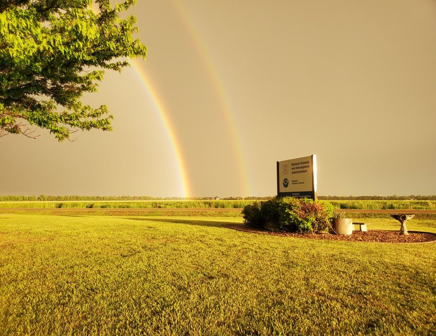
THE RADAR POST Page 2
Intense Winds and Dust Storm Impact the Great Plains on December 15th, 2021
By: Kalitta Kauffman
On December 15th, 2021, a strong low pressure system moved across the Great Plains bringing high
winds, a dust storm, and severe weather to the region. In the Tri-State area, high winds were measured
gusting up to 90 mph with estimated gusts up to 120 mph based on the degree of damage these winds
caused. The strongest winds, both measured and estimated, occurred in Norton County. Damage to pow-
er poles, trees, roofs, and outbuildings were common across the area. Some of the most notable damage
included:
The partial collapse of a rear wall to a building two-stories tall
The total destruction of a barn that was blown onto a road
Damage to the top of a metal grain elevator
Blown over pivot irrigation systems
Besides widespread wind damage, the combination of high winds
and dry conditions created a favorable environment for a wall of
dust to develop. The dust storm moved across the entire Tri-State
area with the passage of a cold front over several hours causing a
complete loss of visibility at times and unhealthy to hazardous air
quality conditions. The initial dust storm and dust that continued
across the area afterward prompted the closure of Interstate 70
from Salina, Kansas to the Colorado border and all Kansas state
highways in the western
half of the state. Numerous
accidents occurred across
the area due to the high
winds and reduced visibil-
ity. December 15th, 2021 Dust Storm
near Tribune, KS
Another hazard brought on
Image: Gabby Valenzuela
by the high winds were
wildfires sparked mostly by downed power lines and one fire
sparked by static electricity interacting with pasture fencing.
Across the Tri-State area there were 6 wildfires that burned an es-
timated 17,800 acres across Wichita, Graham, Sheridan, Gove, and
Logan counties in Kansas and Cheyenne County in Colorado. Un-
fortunately these fires did burn multiple homes, vehicles, power
poles, along with acres of fields and grasslands. There was also
one death due to injuries sustained from a fire in Wichita County,
Kansas. The National Weather Service office in Goodland would
Damaged grain bin near Tribune, KS like to thank everyone who sent in reports both during and after
Image: Gabby Valenzuela the event.
THE RADAR POST                                                                  Page 3
                           A Brief Overview of The Winter Season
                                       By: Kyle Knight

              For the Tri-State area (and much of the south-central United States), the winter sea-
son started out warm and dry. High temperatures were generally in the 50’s and 60’s across the
area including 70’s in the beginning of the month. For rain and snow, very little fell with most of
the area seeing total liquid precipitation around 0.02 to 0.10 inches and only an inch or two of
snow in some portions of the area. This is reflected in the charts below where most of the area
had some of the driest Decembers on record. For the city of Goodland, it was only the second
time in history that no snow fell from September to December. These dry conditions helped con-
tribute to the December 15th dust/high wind storm.

         *Month of December ranks for precipitation and high temperatures from 1893-2022.

        January brought an immediate change as snow fell across most of the area on New Year’s
Day and then again a few days later on January 5th. The snowfall on January 1st stopped the city
of Goodland from reaching its record latest snowfall (Jan 15 in 1950-1951). High temperatures
were a bit cooler with a mix of 50’s/60’s and 20’s/30’s. High temperatures only reached the single
digits across most of the area on January 6th. However, the biggest story of January was the
snowfall that occured on the 25th as an area roughly from Sharon Springs, KS to Burlington, CO
saw around 20 to 28 inches of snow with the rest of the area seeing around 2 to 6 inches. The
reason the snow was so high in that area is an intense band of snow developed and then stayed
roughly in that area for most of the day while producing snowfall rates around 1 to 3 inches per
hour. The snow that fell then lasted for a few weeks after the event and helped keep tempera-
tures cooler in that area compared to the surrounding areas where all the snow melted faster.

                                                                                  Continued next page...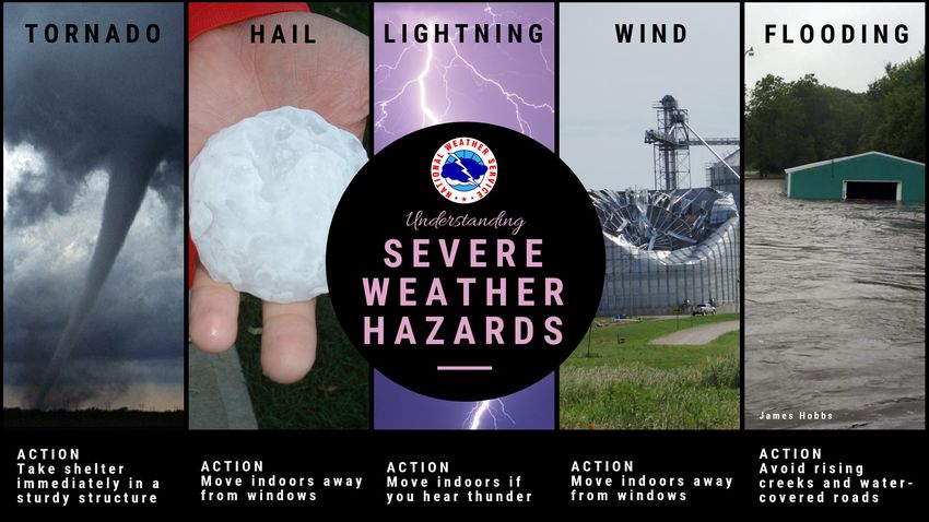
THE RADAR POST                                                                        Page 4

                   *Estimated Snowfall totals for Jan 1st (Top Left), Jan 5th (Top Right)
                                 and Jan 25th (Bottom Middle)

       February continued the same trend in temperatures with a mix of 50’s/60’s and 20/30’s
for highs. However, there were more instances of high in the teens and lows in the negative, es-
pecially near the end of the month. The week of the 21st through the 25th saw daytime tempera-
tures generally remain in the teens and 20’s while morning wind chills were at least -10 or as low
as -30 on the 22nd. The city of Goodland also had a morning low of -10 on the 23rd. In spite of
that week of cold, averaging the temperatures across the month led to near average tempera-
tures. When it came to snow, it was a relatively dry month for most of Northwest Kansas and
Southwestern Nebraska. The exception was a snow storm that produced 1-3 inches of snow near
the KS/CO border at the beginning of the month.

       *Month of February ranks for precipitation and high temperatures from 1893-2022.
THE RADAR POST                                                                  Page 5

                                A Farewell to Jessica and Amanda
                                        By: Tyler Trigg

      Over the past few months the NWS Goodland office has said goodbye to a few forecasters
(Amanda and Jessica). To show appreciation for all of the hard work they have done over the years
we asked them a few departing questions as they begin their new life adventures.

Q: What do your future endeavors include?

Jessica: “ I plan to be the best mom I can be for my son (and any future children), teaching him
important morals, life skills, and about the weather of course”.

Amanda: “ I will be taking a forecaster position at the National Weather Service in Hastings, Ne-
braska. I grew up in eastern Nebraska, so after several years away from my family, I am looking
forward to getting to be a little closer to home and spending some more time with them”.

Q: What will you miss most about the Goodland office?

Jessica: “ I will miss getting to “work severe weather events. There is kind of a rush that you can
only get from watching storms blow up on radar and working to keep communities safe”.

Amanda: “I will miss the camaraderie and the friendships will be what I miss most about working
here. I’ve made some really good friends in the time I’ve been here”.

Q: What was the most memorable experience/weather experience you had here?

Jessica: “In Goodland, my most memorable experience was meeting my husband and starting my
family. When I came to town, I only expected to be here for a short time before moving on, but
there were other plans for me! My most memorable weather experience was the supercell that
traveled along I-70 on September 15, 2016 eventually hitting Goodland. The storm had over 70
mph winds and baseball hail which unfortunately resulted in lots of damage. I remember working
that night knowing what fate was coming for my car parked outside at the office. I quickly re-
grouped through to get the job done and take storm reports to make sure updates were going
out.”

Amanda: “The one event that really stands out to me though was January 15, 2021. This was the
day of the Benkelman Fire and the dust storms that impacted Eastern Colorado and portions of
Northwest Kansas. I think the reason this day stuck out to me was because it was my first time
issuing dust storm warnings. I’ve had the opportunity to research dust storms on the Central High
Plains for the past three years and to see our research being verified by that event”.
                                                                                   Continued next page...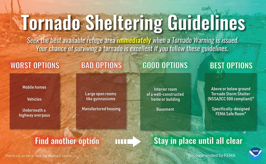
THE RADAR POST                                                                   Page 6
Q: What message or advice would you give the person taking your place?

Jessica: “I would tell him/her to find something he/she is passionate about, then do it to the best
of your ability. Beyond the regular duties there are many areas to help out. Finding your niche
will allow you to thrive at this job and enjoy it even more”.

Amanda: “It is ok to ask questions, Meteorology is a complex field with many different concentra-
tions so you're not going to know everything. Don’t be afraid to ask questions and learn from
those who are experts in particular areas. Get to know people for who they are. Most of the
forecasters work rotating shifts, so you're going to be spending a lot of time together”.

The office will be taking a huge loss losing both Amanda and Jessica as their contributions to both
our social media program as ,Jessica mentioned that was one of her greatest accomplishments was
being able to use her creativity skills to have the office set for many years to come, and our better
understanding of Dust Storms, that Amanda has been focused on, have been significant from
teaching us the newest tools available and creating new graphics. Congratulations Jessica and
Amanda you both will be missed.

                  Jessica                                         Amanda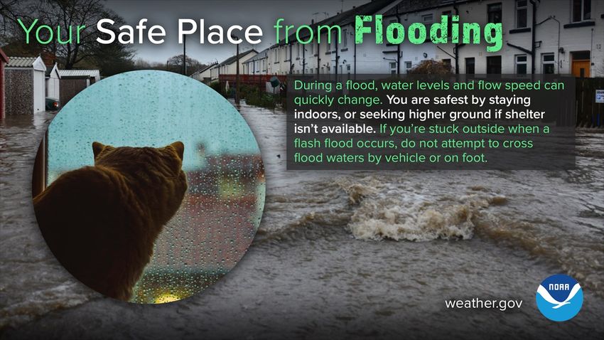
THE RADAR POST                                                                   Page 7
                                      Spring Weather Safety

      With the upcoming severe weather season, now is a good time to review some safety tips
                   and ways to prepare should severe weather come your way.

         First, it is always good to have an emergency kit prepared and ready for a disaster.

                  When severe weather strikes, make sure you know where to shelter.

Continued next page...
THE RADAR POST                                    Page 8
       Know what to do with each severe hazard.

       Know where to go to get weather updates.

                                                  Continued next page...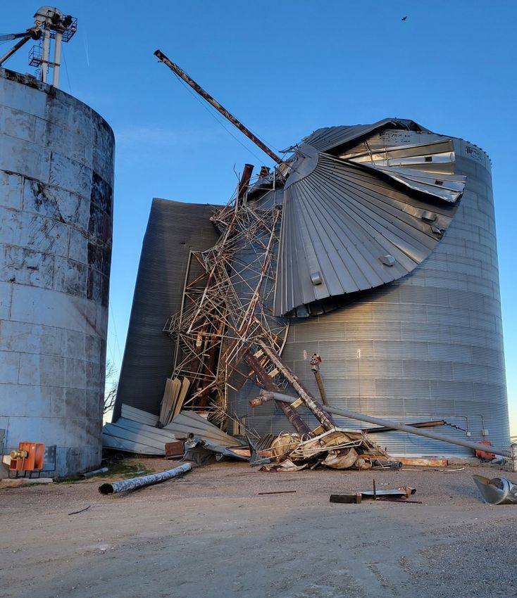
THE RADAR POST                                                        Page 9
Finally, make a Severe Weather Plan. Plan where you and your family will meet up and
                how you will contact each other should a disaster strike.

    With all of this information, we hope you are ready for severe weather season.
We here at NWS Goodland will be there to help you before, during, and after the storm.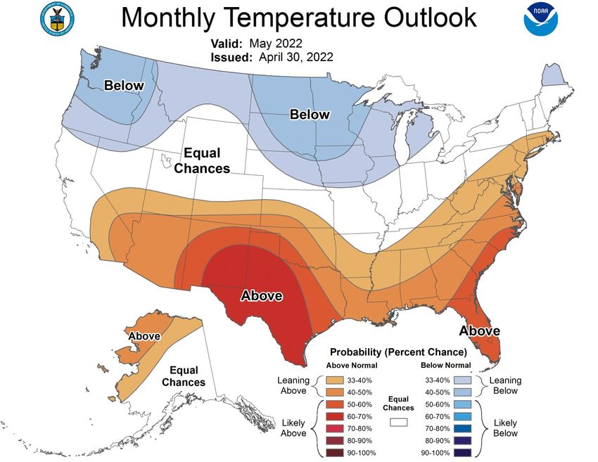
THE RADAR POST                                                               Page 10
                               Weather Radio Programming
                                       By: Jesse Lundquist

Despite the cold weather we have had recently, we are quickly ap-
proaching severe weather season. Along with having a sheltering
plan for severe weather, having a way to stay alert to any warnings
or watches that are issued is equally important. The best way to be
aware of any watches or warnings issued from our forecast office is
through a NOAA Weather Radio. You can find weather radios at
many of the local hardware, farm, or grocery stores in the area.

Perhaps the greatest benefit of a weather radio is being able to pro-
gram it only alert for a specific county. This was once a cumber-
some process with the older weather radio models. However the new models over the past few
years are much easier to program for a specific county or counties. Since the white Midland
weather radios (pictured) are the most commonly found weather radio, it will be used as an exam-
ple of how to program a weather radio for a specific county.

   1. Push the “menu” button.
   2. Use the arrows to go down to “Set Location”, then push the “select” button.
   3. If you want to receive alerts for more than one county, select “Multiple”. Otherwise use
   the up and down arrows to select “Single”. (The weather radio is set to “Any” by default.)
   4. Once you select “Multiple” or “Single” you will then need to push “Select” for each of the
   following options:
       4a. “USA”
       4b. The state you want alerts for.
       4c. The county you want alerts for.
       4d. Continue the process until all counties in which alerts are needed for are entered.
             [If “Single” is selected this only needs to be done once. For multiple counties you
                     will need to go through this process for each county you want alerts for.]
   5. When finished entering the counties push “menu” twice to exit the “Set Location”
   menu. (Each time “menu” is pressed the weather radio menu will go back one menu listing,
   eventually returning to the home screen that has the time.)

A similar process is done to specify what type of warnings or “events” you would like to be alerted
for using the “Edit Events” option. If your weather radio has an option to set the “Alert Type”,
setting it to “Voice” is recommended. Voice alerts allow the weather radio to automatically turn
on so you can hear the warning being read each time a new warning is issued, without having to
push the “weather” button on the weather radio. Once the warning text has been read, the
weather radio audio will turn off. If you have any questions about your weather radio, please con-
tact our office by phone or through social media.
THE RADAR POST Page 11
Kids Korner: Fun With Water
By: Kalitta Kauffman
Ever wondered how rainbows occur after it rains or how the water cycle works? In this issue, we
will provide two experiments that allow you to have fun with water.
Catch a Rainbow
Supplies: Bowl of water Handheld mirror
Flashlight Sheet of white paper
2-3 people
1. Have one person hold the mirror in the bowl of water so it is partially underwater while another
person points the flashlight at the part of the mirror underwater.
2. A third person should hold the piece of paper next to the person holding the flashlight to catch
the light reflected off the mirror. If you do not have a third person, another option would be to
tape the paper to the wall, fridge, etc.
3. If needed, adjust the mirror accordingly to see the rainbow’s colors appear on the paper.
4. To change the rainbow, try changing the amount of water in the bowl.
Create your own miniature water cycle
Supplies: Zipper sandwich bag Marker
Water Tape
Blue food coloring
1. Draw a sun and a cloud in the top half of the bag
2. Pour 1/4 cup of water into the sandwich bag and add a few drops of food coloring.
3. Seal the bag and tape it preferably on a sunny, ideally south-facing, window.
4. Watch the bag over a few days to see how the water cycle works:
As the water warms in the sunlight, it will evaporate into vapor. As the
vapor cools, it will begin changing into liquid (condensation) just like a cloud.
When the water condenses enough, the air will not be able to hold it and the
water will fall down along the side of the bag in the form of precipitation.THE RADAR POST Page 12
Climate Corner
Continued next page...
One Month Summary
The outlook calls for near to above average temperatures and near to above average precipita-
tion for the month of May. The area averages around two and a half to three and a half inches of
precipitation and highs in the mid to upper 70’s.THE RADAR POST Page 13
Climate Corner
Continued next page...
Three Month Summary
The three-month outlook calls for above normal temperatures and below normal precipitation
across the area.THE RADAR POST Page 14
Year to Date* Normal Year Departure from
City
Precipitation (in.) to Date* (in.) Normal (in.)
Goodland 3.34 3.89 -0.55
Burlington 4.68 3.37 +1.31
McCook 3.27 3.92 -0.65
Hill City 2.91 4.48 -1.57
*Data as of May 8, 2022*THE RADAR POST Page 15
WRN Ambassador News
Message from the WCM
Our annual severe weather season is upon us, and
many of us will be impacted. Are you ready?
Before severe weather strikes, take some time to re-
view your safety plans. Ask yourself these questions: what will I do without power for up to a week? Does
my family have enough supplies? Where is my tornado shelter, both at home and work? Do I have a place
to go if there is not suitable shelter? How will my family communicate before, during, and after a weather
event? Have we practiced our severe weather plan lately? How will my family stay safe at the lake, on
camping trips, traveling to school events, or whatever else is going on in our lives?
Answers to these questions could save your life, and the lives of your family, friends, and community
members! The National Weather Service, along with FEMA and other emergency response and emergency
management agencies, recommend that you have a disaster plan and an emergency kit. Your disaster plan
should address safety, sheltering, communication, and recovery. Your emergency kit needs to contain all
the supplies you will need in a disaster scenario, including medical supplies, food and water, and anything
else you might need.
In a normal year, the Tri-State Region averages 23 tornadoes, over 100 reports of severe winds, and
around 250 reports of severe hail, or greater than the size of a quarter. The majority of the tornadoes will
remain over open fields in our rural landscape, but they can and do strike our towns and cities, as well as
our farmsteads. In fact, just last year, the town of Selden, Kansas was hit hard by a tornado on May 24 th,
2021. Widespread damage was observed across the town as a result of the EF-1 tornado, which produced
winds as high as 110 mph. In addition, straight-line winds can do just as much damage as a tornado, and
sometimes, more damage than a tornado. A microburst struck Burlington, Colorado on September 1 st,
2021 causing damage consistent with winds up to 115 mph, or as strong as an EF-2 tornado. Overall, the
point I want you to consider is to take all storms seriously and to be prepared as over the next 6-7 months,
severe weather can strike at any time and the disaster could be of a great magnitude.
Ryan Husted, Warning Coordination Meteorologist
Interested in Joining Weather-Ready Nation?
For information on how to become a Weather-Ready Nation Ambassador, please contact the Warning Co-
ordination Meteorologist, Ryan Husted (Ryan.Husted@noaa.gov) or NWS Goodland meteorologists
(nws.goodland@noaa.gov or 785-899-7119). To learn more about this national initiative, visit the Weather
-Ready Nation website (www.weather.gov/wrn), or the NWS Goodland WRN website (https://
www.weather.gov/gld/WRN_Ambassadors).THE RADAR POST Page 16
WRN Ambassador News
Storm Spotters: Our Eyes in the Field
By Jesse Lundquist
Severe weather season is here. This is the time of year we heavily rely on our storm spotters
because spotters are our eyes in the field; they help us see what our radar cannot. Spotters
also put the radar data into context for us, helping us better understand what the storm is do-
ing.
Because storm spotters are so important to us, we have conducted several virtual storm
spotter training sessions this year. These sessions served as a reminder of the role of the
spotter during severe weather, and how important weather reports from spotters are to our
severe weather operations. We are not asking spotters to be storm chasers; but instead to re-
port what they see wherever they are located. As we have said in prior years, don’t expect
someone else to report severe weather to us. If you see a weather phenomena that looks se-
vere or close to it, please let us know. We would much rather be inundated with phone calls
than not receive any.
In case you were not able to attend a virtual spotter training session this year, here are some
of the highlights that are important to remember while out spotting:
Watch vs. Warning: A watch is issued when conditions are favorable for severe weather to
occur. A warning is issued when severe weather is either eminent or already occurring.
Examples of what a watch (left) and a warning (right) look like.
Please report hail referencing known, standard sizes so we know how large the hail is. Also,
report the largest hailstone you see. The larger the hailstone, the stronger the storm is.
When taking shelter from a tornado, go to the lowest level of the building and put as many
walls between you and the outside as possible.
Wall clouds are attached to the base of the updraft. The updraft is at the back of the storm. If a
Continued next page...THE RADAR POST Page 17
WRN Ambassador News
Storm Spotters cont.
tornado will form, it will be from this cloud.
Examples of wall clouds. Images courtesy of NSSL (left) and NWS Cheyenne (right)
Shelf clouds are at the front part of the
storm. Rain and increased wind may occur
behind the shelf cloud.
A funnel cloud does not contact the
ground. As soon as it does, it is now a torna-
do. Watch for a circulation below a funnel
cloud. If there is one, a tornado has now
formed.
A shelf cloud moving over Goodland, KS.
Image courtesy of Amanda Wekesser
Funnel Cloud. Tornado
Image courtesy of Daniell Railey Image courtesy of Christopher Warner
If there are flood waters over a road, turn around don’t drown. The depth and speed of the wa-
ter are unknown, plus you don’t know what the condition of the road is underneath the water.THE RADAR POST Page 18
WRN Ambassador News
Where Will You Go?
By Jesse Lundquist
When hazardous severe weather is moving towards your location, where will you go for shel-
ter? Do you have a plan of where to take shelter no matter where you are located? Don’t as-
sume severe weather will only occur when you are at home. Think about where you would take
shelter if you are on the road, at a friend’s house, or watching a baseball game.
If you have access to a building when severe weather is approaching, the best place to be is the
lowest floor or basement if available. The higher you are above ground, the more likely hail or
debris from damaging winds will cause you injury.
If on the road in a hail storm, stop on the side of the road. Don’t stop under an overpass. This
will likely lead to an accident or delay emergency vehicles that need to get through to storm
victims or other emergencies. Most hail storms
don’t last more than 15 or 20 minutes. After that
you can move on. If the hail is big enough to
shatter windows, protect your eyes and
head. Don’t leave the vehicle during a hail
storm. Leaving the vehicle for even a few seconds
is enough time for the hail to cause injury. If a
tornado is approaching, drive away from it at a
90o angle. For example, if the tornado is headed
northeast, drive southeast away from it. Don’t Parking under an overpass is not advised
outrun, out maneuver the tornado! If there is no
during severe weather.
time to evade the tornado, get into a ditch and
protect your head to lower the chance of being hit Image courtesy of Freddy McKinney
by debris.
If in a mobile home, go to a storm shelter. An EF-2 tornado
will completely destroy a mobile home. Therefore, do not
take shelter in them. If outside when severe weather ap-
proaches, take shelter in the nearest sturdy building or com-
munity storm shelter. If no building is available, sheltering in
a ditch and protecting your head is the last “ditch” resort.
While out enjoying the spring weather, don’t forget to re-
main aware of where you need go to take shelter from se-
Damage to a mobile home from vere weather, should the need arise. You need to be pre-
pared to act when a severe thunderstorm warning is issued
the Selden, KS tornado on May
for your location. Having a plan ahead of time for where to
24th, 2021 take shelter will help you stay safe when thunder roars!THE RADAR POST Page 19
WRN Ambassador News
What else can the National Weather Service do for you?
By Ryan Husted
The National Weather Service is a name brand that so many of you across the High Plains rec-
ognize. The NWS issues a 7-day forecast, all watches, warnings, and advisories, river forecasts,
aviation forecasts, distributes and maintains climate information, provides programing for the
NOAA Weather Radios, provides weather observations via radar, satellite, and automated sur-
face observation systems (ASOS), and provides outreach to the local communities in the form
of Spring Spotter Talks. The NWS also provides a large presence on our national website, our
local website and through social media feeds, through Facebook and Twitter. But is that all the
National Weather Service does? No. Here are a few services the National Weather Service pro-
vides that you may not know about!
Storm Data
After weather events, NWS Goodland collects reports from our emergency managers, local dis-
patch centers, storm spotters, the general public, and many others. Once we collect that data,
it is quality controlled and archived for later use. What might this information be used for? The
data can be used for research intended to improve forecasts and warnings. The data is often
distributed to local, state, and federal governments to better inform community planning/
improvement grants and disaster declarations. The data can be used in court proceedings or
insurance claims (likely need the “official” data, once it has been quality controlled). Finally, the
general public can use the data for whatever educational and safety purposes that may not
have been previously discussed.
Sample of StormData from May 24, 2021 for Northwest Kansas.
Image courtesy of the National Weather Service
Decision Support Services
The National Weather Service is moving towards a work model in which we work more closely
with our key local, state, and federal government partners. This does not mean that you will
Continued next page...THE RADAR POST Page 20
WRN Ambassador News
National Weather Service cont.
see any changes to your current service.
What this does mean is that the National
Weather Service will support your local
communities, under the premise of safety,
to ensure great decisions are made to keep
everyone safe. Meteorologists can be de-
ployed to both planned (ex. a fair, festival,
sporting events, drills/exercises, or other
large events where a high volume of people
will be vulnerable to weather) or unplanned
(a wildfire response, disaster recovery Black Hawk Helicopter operating near St. Francis,
efforts). We come fully equipped and em- KS in November 2019.
bed with the government officials oper- Image courtesy of Jesse Lundquist
ating, providing weather updates immedi-
ately upon request. The minutes saved by meteorologists serving as part of a response can be
the difference between all those working that event getting to shelter or not.
Plume Forecasting
A train has derailed near a town. Several rail
tanker cars were damaged, causing a chemi-
cal spill and toxic fumes to escape. This is a
volatile chemical known to explode and to be
poisonous when inhaled by humans. All resi-
dents downwind of the plume need to evacu-
ate immediately or face being hospitalized or
killed from the toxic plume. But, where is the
plume going? With information provided by
first responders, the National Weather Ser-
vice can provide a model/forecast of where
this plume of toxic fumes will move. The pro-
gram is called Hysplit, and it can be run in a
matter of minutes. There are other customi-
zable features to the forecast too, such as is
this a continuous release or an explosive re-
lease, the amount of chemical and type of
chemical released, the weather observa-
Sample plume forecast showing where a toxic tions in the area of the incident, and a varie-
plume might go. ty of other inputs that can improve the fore-
cast for that particular location. Armed with
Image courtesy of NWS Detroit
Continued next page...THE RADAR POST Page 21
WRN Ambassador News
National Weather Service cont.
the latest plume forecast from the National Weather Service, local emergency management
and first responders will be able to pinpoint locations that need to be evacuated immediately.
Participate or Lead Drills/Exercises
Another capability of the National Weather Service is to apply our weather expertise into drills
and exercises held in the community! We are able to build resources to help you simulate a
real event, making the drill seem much more like a real-life scenario. This could be done for
tornado drills at area schools, table-top or full-scale exercises within the community, or plan-
ning and/or after action review conversations on how to handle weather-related disasters. The
National Weather Service is happy to assist you in any way that may lead to a beneficial im-
provement in safety procedures.
Simulated warning for a table top exercise in Norton, KS.
Image courtesy of NWS GoodlandTHE RADAR POST Page 22
Useful Links Contact Us
· Storm Prediction Center
- www.spc.noaa.gov
· Weather Prediction Center National Weather Service
- www.wpc.ncep.noaa.gov
· Climate Prediction Center 920 Armory Road
- www.cpc.ncep.noaa.gov Goodland, KS 67735
· Climate Data
- www.ncei.noaa.gov Phone:
· CoCoRaHS
- www.cocorahs.com 785-899-7119
· Weather Models
- www.ncep.noaa.gov
Fax:
· Space Weather 785-899-3501
- www.swpc.noaa.gov
E-mail:
SciJinks
-scijinks.gov/ w-gld.webmaster@noaa.gov
Website:
http://www.weather.gov/gld
Facebook:
http://www.facebook.com/
nwsgoodland
Twitter:
https://twitter.com/NWSGoodlandYou can also read