Coastline Processes and Manly's Seawalls
←
→
Page content transcription
If your browser does not render page correctly, please read the page content below
Hydraulic Engineering Section
Institute for Geotechnics, Waste and Hydro Sciences
Civil Engineering Department
University of Wuppertal, Germany (BUW)

in association with

Water Research Laboratory (WRL)
School of Civil and Environmental Engineering
University of New South Wales (UNSW)
Sydney, Australia

Coastline Processes
and Manly’s Seawalls
Practical Problem

TEXed and written by Mario Oertel
”The Twelve Apostles Gallery - Victoria”
Contents

Acknowledgements                                                                         v

Introduction                                                                            vii

I    Coastline Processes                                                                 1

1 The Beach System                                                                       3
     1.1   General . . . . . . . . . . . . . . . . . . . . . . . . . . . . . . . . .     3
     1.2   Wind . . . . . . . . . . . . . . . . . . . . . . . . . . . . . . . . . . .    4
     1.3   Waves . . . . . . . . . . . . . . . . . . . . . . . . . . . . . . . . . .     4
     1.4   Waterborne Sediment Transport . . . . . . . . . . . . . . . . . . . .         5
           1.4.1   General . . . . . . . . . . . . . . . . . . . . . . . . . . . . .     5
           1.4.2   Longshore Transport . . . . . . . . . . . . . . . . . . . . . .       6
           1.4.3   Onshore/Offshore Transport . . . . . . . . . . . . . . . . . .        6

2 Coastal Protection                                                                     9

3 Summary                                                                               11

II     Manly’s Seawalls and their History                                               13

4 General                                                                               15

5 Seawalls                                                                              19
     5.1   Description . . . . . . . . . . . . . . . . . . . . . . . . . . . . . . .    19
     5.2   Classification of Seawalls . . . . . . . . . . . . . . . . . . . . . . . .   19

                                                 i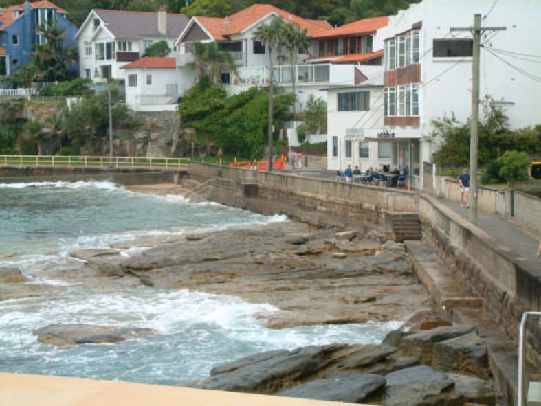
ii                                                                             CONTENTS

     6 The History of Manly’s Seawalls                                                    21
       6.1    General . . . . . . . . . . . . . . . . . . . . . . . . . . . . . . . . .   21
       6.2    The Marine Parade Seawall . . . . . . . . . . . . . . . . . . . . . .       21
       6.3    Manly Ocean Beach Seawall . . . . . . . . . . . . . . . . . . . . . .       22
       6.4    Construction and Damage . . . . . . . . . . . . . . . . . . . . . . .       22

     7 Present Seawalls at Manly’s Beaches                                                25
       7.1    General . . . . . . . . . . . . . . . . . . . . . . . . . . . . . . . . .   25
       7.2    Manly’s Seawall Types . . . . . . . . . . . . . . . . . . . . . . . . .     25
              7.2.1   Rigid Reinforced Earth Seawall . . . . . . . . . . . . . . . .      27
              7.2.2   Rigid Vertical Blockwork Seawall . . . . . . . . . . . . . . .      27
              7.2.3   Rigid Subvertical Blockwork Seawall . . . . . . . . . . . . .       27
              7.2.4   Rigid (semi-rigid) Sloped Seawall . . . . . . . . . . . . . . .     28
              7.2.5   Rigid Sloped Stepped-Face Seawall . . . . . . . . . . . . . .       28
       7.3    Manly’s Seawall Area I . . . . . . . . . . . . . . . . . . . . . . . . .    28
       7.4    Manly’s Seawall Area II . . . . . . . . . . . . . . . . . . . . . . . .     28
       7.5    Manly’s Seawall Area III . . . . . . . . . . . . . . . . . . . . . . . .    31
       7.6    Manly’s Seawall Area IV . . . . . . . . . . . . . . . . . . . . . . . .     31
       7.7    Manly’s Seawall Area V . . . . . . . . . . . . . . . . . . . . . . . .      31
       7.8    Manly’s Seawall Area VI . . . . . . . . . . . . . . . . . . . . . . . .     33
       7.9    Manly’s Seawall Area VII . . . . . . . . . . . . . . . . . . . . . . .      33
       7.10 Manly’s Seawall Area VIII . . . . . . . . . . . . . . . . . . . . . . .       36

     8 Summary                                                                            39

     9 Final Statement                                                                    41

     III     Appendix                                                                     45

     Appendix - Glossary of Coastal Terminology                                           47
List of Figures

 1.1   Coastal Zone Terminology [2] . . . . . . . . . . . . . . . . . . . . .        5
 1.2   Sediment Budget [2] . . . . . . . . . . . . . . . . . . . . . . . . . .       5
 1.3   Beach Profiles: Accreted and Storm Conditions [2] . . . . . . . . . .         7

 4.1   Australia - Sydney - Manly     . . . . . . . . . . . . . . . . . . . . . .   16
 4.2   Manly’s Seawall Areas . . . . . . . . . . . . . . . . . . . . . . . . .      17

 7.1   Manly’s Seawall Types . . . . . . . . . . . . . . . . . . . . . . . . .      26
 7.2   Manly’s Sloped Stepped-Faced Seawall . . . . . . . . . . . . . . . .         27
 7.3   Manly’s Seawall Area I . . . . . . . . . . . . . . . . . . . . . . . . .     29
 7.4   Manly’s Seawall Area II . . . . . . . . . . . . . . . . . . . . . . . .      29
 7.5   Manly’s Seawall Area II . . . . . . . . . . . . . . . . . . . . . . . .      30
 7.6   Manly’s Seawall Area II . . . . . . . . . . . . . . . . . . . . . . . .      30
 7.7   Manly’s Seawall Area III . . . . . . . . . . . . . . . . . . . . . . . .     31
 7.8   Manly’s Seawall Area IV . . . . . . . . . . . . . . . . . . . . . . . .      32
 7.9   Manly’s Seawall Area V . . . . . . . . . . . . . . . . . . . . . . . .       32
 7.10 Manly’s Seawall Area V . . . . . . . . . . . . . . . . . . . . . . . .        33
 7.11 Manly’s Seawall Area VI . . . . . . . . . . . . . . . . . . . . . . . .       34
 7.12 Manly’s Seawall Area VI . . . . . . . . . . . . . . . . . . . . . . . .       34
 7.13 Manly’s Seawall Area VI . . . . . . . . . . . . . . . . . . . . . . . .       35
 7.14 Manly’s Seawall Area VII . . . . . . . . . . . . . . . . . . . . . . .        35
 7.15 Manly’s Seawall Area VII . . . . . . . . . . . . . . . . . . . . . . .        36
 7.16 Manly’s Seawall Area VIII . . . . . . . . . . . . . . . . . . . . . . .       37
 7.17 Manly’s Seawall Area VIII . . . . . . . . . . . . . . . . . . . . . . .       37
 7.18 Manly’s Seawall Area VIII . . . . . . . . . . . . . . . . . . . . . . .       38

                                           iii
Introduction

This report was written as a part of an internship at the Water Research Labora-
tory (WRL) of the University of New South Wales (UNSW) in Australia.

The State New South Wales (NSW), the most populous state of Australia, is lo-
cated in the southeast of the country. Nearly 6,500,000 people live in an area of
801,600 square km. These are approximately 30% of the Australian inhabitants.

The coastline of NSW is characterised by small pocket beaches bounded by rocky
headlands in the south, and longer sweeping beaches of golden sand in the north.
Coastal areas are major destinations for local, national and international tourists.
More than 80% of the State’s population lives and works along the eastern seaboard.
The coastline is under regular attack from the natural forces of wind and waves. In
response to these processes, the coastline is ever changing. Beaches and sand dunes
erode and are rebuilt in response to wave action; sand dunes can migrate inland in
response to wind attack. Man’s activities in the coastal zone can exacerbate these
processes.

Coastline hazards are not a minor problem. Beach erosion accompanying storms
of the early 1970’s caused the loss of 20 houses and other assets valued at many
millions of dollars along the central and north coasts. Coastal erosion became a
problem for homes, commercial buildings, streets etc. that were built up all along
the coastlines. So, in 1975, the NSW State Government established the Beach
Improvement Program to protect heavily used beaches. In the following years up
to today, lots of other initiatives relevant to coastal management were enacted. [2]

This report is split into two main parts. The first part is about coastline pro-
cesses, especially about coastal erosion and protection at sandy beaches. This part
should create a foundation of knowledge for the need of seawalls, to assist in un-
derstanding the following chapters. The second part handles with Manly’s seawalls
and their history, including a chapter about seawalls in general.

A glossary of coastal terminology for assisting readers in understanding techni-
cal terms is given in the Appendix.

                                            vii
Part I

Coastline Processes
Chapter 1

The Beach System

1.1     General
Beaches and coastal lands are exposed to never ending attack by the sea and the
atmosphere. Waves, winds (storms) and increased water levels reshape the beaches
and move sediments onshore, offshore and alongshore. This can damage or destroy
coastal developments and reduce beach amenity. [2]

To manage all these coastline hazards, it is necessary to understand the various
processes that cause them.

There are many different influences that may change, destroy or damage the
beaches and the coastal structures:

   • wind,

   • (storm) waves,

   • waterborne sediment transport,

   • elevated water levels,

   • currents,

   • dune vegetation,

   • rainfall and runoff,

   • coastal entrances,

   • climate change, and

   • human activities.

                                          3
4 1 THE BEACH SYSTEM
In the following only the first three listed possibilities are described.
1.2 Wind
Strong winds (intense storms) close to the coast are able to erode the shoreline
and to damage coastal developments, e.g. unroofing buildings, uprooting trees and
even causing the collapse of buildings. Sediment transport associated with strong
winds accelerates the migration of sand dunes and the smothering of coastal de-
velopments. Also storms may increase the water levels which damage the beaches
and coastal structures, too.
The coastline of NSW is frequently attacked by severe storms originating over the
Tasman Sea. These storms are capable of causing rapid erosion along the south-
eastern coastline. The low pressure systems from the Tasman sometimes generate
secondary lows, which intensify the storm systems. Under these conditions gale
force winds, with a wind speed of above 50 km/hour, are generated. In May 1974,
for example, a secondary low developed off the NSW coast, creating wind speeds
of over 140 km/hour between Northern Sydney and Newcastle. This storm caused
severe erosion of beaches and destroyed many built assets.
1.3 Waves
Waves (generated by wind blowing) are a very dominant phenomena that shapes
the coastline. They are one of the reasons for erosion, longshore drift and elevated
water levels - because of their capacity to transport sediment. This energy is mostly
dissipated in the short distance between wave breaking and the wave runup limit.
Within the surfzone, waves are the major mechanism of waterborne sediment trans-
port.
A coastal structure must withstand the influence of waves and their maximum
forces.
Important characteristics of waves are:
• wave height,
• wavelength,
• wave period,
• wave speed, and1.4 WATERBORNE SEDIMENT TRANSPORT 5
Figure 1.1: Coastal Zone Terminology [2]
Figure 1.2: Sediment Budget [2]
• wave direction.
It is also important to know about the shoaling, refraction, diffraction, breaking
and reflection of a wave (see Appendix).
1.4 Waterborne Sediment Transport
1.4.1 General
The waterborne sediment transport is a natural process. Sediment is transported
onshore, offshore and alongshore by the action of waves and currents (see figure
1.2). An understanding of waterborne sediment transport is essential to the better6 1 THE BEACH SYSTEM
management of coastal areas.
For this, four different zones can be distinguished (see figure 1.1):
1. Deep Water Zone: Here, the water depth is large, the wave crests are straight
and its velocity and direction relative to the shore are constant.
2. Refraction Zone (Breaker Zone): The waves ”feel” the bottom, their wave
length and velocity along the crest vary as they propagate towards the shore
from the deep ocean. Each wave crest progressively bends and attempts to
align itself parallel to the shoreline. The waves steepen and eventually break.
3. Surf Zone: The zone between the breaker zone and the shore. The breaker
line is not fixed, since, the breaking varies with the wave height. In this
zone the longshore sediment transport is significant and responsible for the
shoreline changes, especially due coastal structures.
4. Swash Zone: This is limited by the highest point on the beach that the
breaking waves running up to, and the lowest point to which the water recedes
between waves. [6]
1.4.2 Longshore Transport
The longshore transport refers to the movement of waterborne sediments along
the coast. This occurs predominately in the surf zone. Depending upon wave
and current situations, longshore drift will trend towards one end of the beach or
the other. On some beaches, sediment transport in both directions is balanced,
resulting zero net drift. On other beaches, there is commonly a potential for net
drift because of dominant wave climates. [2]
1.4.3 Onshore/Offshore Transport
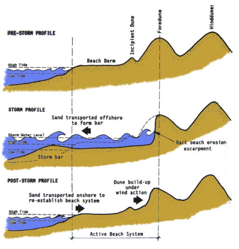
During storms, the steep waves erode sand from the beach berm and dune areas
and transport it offshore to built a ”storm bar”. A pronounced ”dune scarp” in
the foredune area commonly marks the landward extent of storm erosion. The
resulting beach profile is termed the ”Storm Profile” (see figure 1.3). The effect of
a storm bar is to widen the surf zone and flatten the slope of the surf and swash
zones. This causes waves to break further offshore, which imposes a self regulating
limit on beach erosion.
At other times, ocean swell of longer period and lower height tends to rebuild
the beach with sand from the offshore bar (see figure 1.3). This rebuilding process
commences immediately after a storm.1.4 WATERBORNE SEDIMENT TRANSPORT 7
Figure 1.3: Beach Profiles: Accreted and Storm Conditions [2]8 1 THE BEACH SYSTEM
A major storm event can move some of the sand offshore beyond a depth from
which it can not return to the beach system. When this occurs there can be a net
permanent loss of sand from the beach’s sediment system, or it takes several years
to take most of the sand back to the beach. [2] [6] [3]Chapter 2
Coastal Protection
A populated coastline requires some degree of protection against destructive events
which may threaten infrastructure sited close to the active zone. There is a need for
measures which protect humans and their properties against these natural effects.
A variety of coastal protection measures can be used to enhance or preserve beach
amenity and to protect coastal developments at risk of erosion or recession. These
include
• seawalls,
• groynes,
• offshore breakwaters,
• bulkheads,
• revetments,
• jetties,
• artificial headlands,
• beach nourishment, and
• dune rehabilitation and management.
The requirements of a beach erosion control and protection measure follows from
the past and the technical progress up to date. To be effective, the type of pro-
tection must be compatible with coastal processes at the site. Information about
the longshore sediment transport, together with likely long term shoreline changes
from erosion, accretion or recession is required. A detailed understanding of coastal
processes and hazards is essential to the successful design, construction and oper-
ation of coastal protection works. [2]
910 2 COASTAL PROTECTION
In the following of this report only the protection measure ”Seawall” will be de-
scribed detailed (see Part II on page 15 ff).Chapter 3
Summary
Sandy beach coastlines are ever changing areas under continuous change by natural
forces. Where public and private infrastructure (and its occupants) has been con-
structed within this naturally active zone, structural protection may be needed.
1112 3 SUMMARY
Part II

Manly’s Seawalls and their
         History
Chapter 4
General
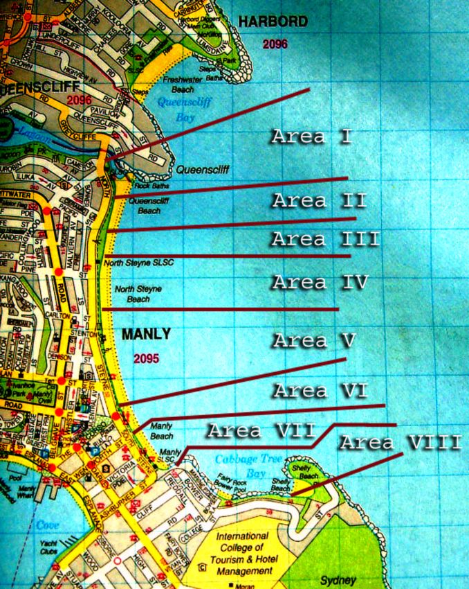
Manly, a suburb in the North of Sydney (see figure 4.1), has over 1.5 km of long
sandy beaches. Most of the shore faces east to east-north-east to the Pacific Ocean/-
Tasman Sea. Nearly the whole beach is exposed to waves and storms, though the
south end in particular has some protection from waves from the south to south-
east. The effects of ocean storms on the built environment has been mitigated by
the construction of seawalls.
On Manly’s beaches the most prominent shore protection measures are the sea-
walls. From Queenscliff Beach in the north down to Shelly Beach in the south
(approx 2.5 km) there is a connected structure, consisting of different types of sea-
walls. For the following, the area of Manly’s beaches - including Queenscliff Beach,
North Steyne Beach, Manly Beach, Fairy Bower Beach and Shelly Beach - will be
classified into different sections (Manly’s Seawall Areas I-VIII, as shown in figure
4.2), in which exist the varying types of seawalls.
1516 4 GENERAL
Figure 4.1: Australia - Sydney - Manly17 Figure 4.2: Manly’s Seawall Areas
18 4 GENERAL
Chapter 5
Seawalls
5.1 Description
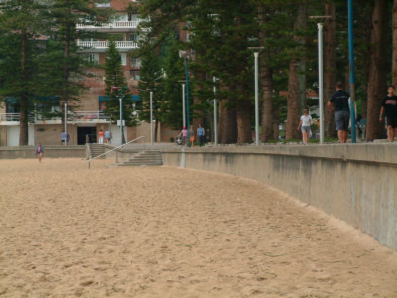
A Seawall is a structure to separate the land area from the water area. It is built
along the shoreline parallel to the beach. The primary purpose of a seawall is the
protection of areas in the rear of the beach against attack of waves and storms and
to impose a landward limit to coastal erosion. Seawalls are necessarily massive and
expensive and should be constructed only where the adjoining shore is highly de-
veloped and storm attack is severe. They can be built of many materials including
steel, concrete, rock, plastics, bitumen, ceramics etc. The face of a seawall may be
vertical, subvertical, curved, stepped or sloping.
Seawalls can be constructed anywhere up the beach profile, but they are best
located in the higher regions of the beach where only waves from extreme storm
events can reach them. If constructed too far seaward on a sandy beach, they
destroy beach amenity. [2][6]
5.2 Classification of Seawalls
Seawalls can be classified as:
• rigid,
• flexible, or
• semi-flexible. [2]
A rigid seawall could be a gravity wall, sheet piling, a caisson or a concrete revet-
ment. They have a compact nature with a minimum plan area with the tendency
not to harbour rubbish. However, they can fail by a single large wave, toe erosion
1920 5 SEAWALLS
(undermining) or geotechnical instability (overturning) - catastrophically. Mostly
rigid seawalls tend to be highly reflective to incoming waves which can result in
accelerated sand loss in front of the wall during a storm, and delay beach rebuilding
following a storm. To protect the foundations of a rigid seawall from undermining,
rock scour blankets, gabions, etc. can be used. It is also possible to found the
structures at depth on non-erodible materials. However, there’s a general tendency
away from rigid structures due to their cost and risk of catastrophic failure.
Flexible seawalls are constructed from quarry rock, shingle and specially manu-
factured concrete units. They are not as compact as rigid seawalls but they can
withstand striking deformation without total failure occurring. The failure is pro-
gressive rather than catastrophic. Flexible seawalls are also less reflective than
rigid structures. A disadvantage is the tendency to harbour rubbish because of the
broken nature of their surface.
A combination of the characteristics of rigid seawalls and flexible seawalls are the
semi-flexible seawalls. They are compact but may not fail as easy as rigid seawalls.Chapter 6
The History of Manly’s Seawalls
6.1 General
Manly’s 2.5 km long seawall has been constructed in stages between 1887 to 1999
to a number of different designs. From time to time, the wall has suffered damage
during storms. Consequently, over the years, about 20% of the original seawall at
Manly has been rebuilt or substantially repaired.
In the past, Manly’s seawall was split into two main sections; the Marine Pa-
rade Seawall built in the late 1890’s occupying the southern 800 metres or so of the
embayment shoreline, and the Manly Ocean Beach Seawall which was commenced
at The Corso some ten years prior to the Marine Parade seawall but only finally
completed at Queenscliff in the late 1930’s.
Over the more than 110 year history of the walls, there have been nine instances
of recorded damage. This is an important finding that shows that, over the full
life of the structure, the wall has been damaged, on average, once every 12 years. [4]
Initially, this more than 100 years old seawall was built as a vertical and subvertical
rigid blockwork seawall (see subsections 7.2.2 and 7.2.3).
6.2 The Marine Parade Seawall
The Marine Parade Seawall (Area VIII, Section 1) was built in 1897/98 when the
sewer was provided. It was clearly founded on bedrock in most areas and was
fronted by exposed reef except at Fairy Bower Beach.
Today, the Marine Parade Seawall remains largely as originally constructed except
for concrete toe reinforcement on Fairy Bower Beach. The only notable instance
of storm damage that has been recorded for this seawall was in May/June 1974.
2122 6 THE HISTORY OF MANLY’S SEAWALLS
6.3 Manly Ocean Beach Seawall
Construction of the Manly ocean beach seawall (Areas I to VII, Section 2) com-
menced at The Corso in 1887 and was only finally completed some 70 years later at
the northern end of the embayment. Today, the once connected monotype struc-
ture is split into many areas due to seawall damage and failures in past storm
events.
6.4 Construction and Damage
In the following table the construction and damage dates are listed. The second col-
umn gives the information about the area (see Manly’s Seawall Areas in figure 4.2).6.4 CONSTRUCTION AND DAMAGE 23
Date Area
1887 VIII first seawall constructed (360m)
[Manly Ocean Beach Seawall]
29.5.1889 IV to VIII trees uprooted, fences damaged and
part of Manly Corso submerged
1897/98 V to VII seawall extended (219m)
[Marine Parade Seawall]
7.-10.5.1898 IV + V two large trees uprooted and part of
seawall collapsed
1900 V wall extended (approx 100m)
1902 V wall extended (10m)
14.5.1913 VII dressing sheds and walls washed away
14.-16.5.1913 VII dressing sheets demolished
May 1913 VI + VII storm washed away large sections of
promenade and seawall; beachfront
facilities destroyed
1932 IV + V seawall first constructed
1937/38 III seawall extended
1938 I + II seawall first constructed
1939 III to V heavy seas cause damage at Manly
1942 VII seawall faced with concrete
1943 II seawall destroyed, not replaced after
storm
26.6.1950 III + IV huge seas smashed 100-150 yards of
seawall; council engineers estimated
20,000 AU$ damage
1950 II + III wall collapsed
1955/56 IV seawall reconstructed, seawall replaced
with concrete faced revetted embankment
and coping at promenade level
1962 II reconstructed seawall, comprising precast
concrete blocks
5.9.1967 VII waves wash away 20m of seawall
May 1968 I + II storm waves dislodge coping stones24 6 THE HISTORY OF MANLY’S SEAWALLS
Date Area ...continuation
May 1974 I to III coping stones dislodged from crest
of wall due to wave action; seawall scour
apron undermined causing subsidence of
pattern placed blockwork wall
May/June 1974 VIII part of seawall damaged
1975 VII ”Reinforced Earth” seawall constructed
1998/99 VI stepped-face seawall constructedChapter 7
Present Seawalls at Manly’s
Beaches
7.1 General
As described in Chapter 4, Manly’s connected seawall can be classified into different
areas. In the following each of these areas will be photographed and described.
These areas will be described from north (Queenscliff) to south (Shelley Beach).
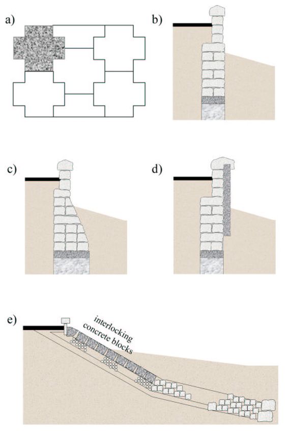
7.2 Manly’s Seawall Types
The different cross section types of Manly’s seawalls may be grouped into six prin-
cipal rigid seawall categories:
• vertical ”Reinforced Earth” seawall (see figure 7.1a),
• vertical blockwork seawall (see figure 7.1b),
• subvertical blockwork seawall (see figure 7.1c),
• vertical concrete faced blockwork seawall (see figure 7.1d)
• sloped interlocking concrete block seawall (see figure 7.1e), and
• sloped stepped-face seawall (see figure 7.2).
On the top of every type of Manly’s seawalls, there is a continuous concrete slab
or clay paver footpath following the seawall alignment.
2526 7 PRESENT SEAWALLS AT MANLY’S BEACHES
Figure 7.1: Manly’s Seawall Types7.2 MANLY’S SEAWALL TYPES 27
Figure 7.2: Manly’s Sloped Stepped-Faced Seawall
7.2.1 Rigid Reinforced Earth Seawall
The Reinforced Earth seawall in Manly is about 20 years old, and has suffered no
damage. It was built with many prefabricated concrete panels which are anchored
in the backward ground. The result is a typical vertical ”Reinforced Earth” surface
as shown in figures 7.1a.
7.2.2 Rigid Vertical Blockwork Seawall
The vertical blockwork walls are the oldest at Manly (more than 100 years old),
and they have withstood the test of time surprisingly well. Over 50% of the overall
embayment seawall is vertical blockwork. Notable instances of storm damage have
occurred at Fairy Bower in 1974. In total, it is estimated that some 5 or 10% of
the original vertical blockwork walls have been damaged or destroyed since con-
struction.
As shown in figure 7.1b the vertical blockwork walls are gravity walls, which were
made out of big stones - grounded on bedrock or on small foundations. In some
areas, the walls are protected against undermining/scour of their footing by a rock
apron/toe protection rocks on their seaward side. This rock protection is generally
buried beneath the sand, but becomes exposed after large storm events.
In 1942 the vertical blockwork walls north of the Manly Surf Club up to the Corso
were faced with concrete (see figure 7.1d).
7.2.3 Rigid Subvertical Blockwork Seawall
Subvertical blockwork seawalls are of similar appearance to vertical blockwork walls
- with the difference of a sloped surface under the sand level (see figure 7.1c).28 7 PRESENT SEAWALLS AT MANLY’S BEACHES
The majority of damage to the Manly embayment seawall has occurred to these
subvertical blockwork structures. About 40% of the original length of these walls
failed during storms in 1943 and 1950.
7.2.4 Rigid (semi-rigid) Sloped Seawall
Sloped walls cannot be classified into a special seawall group. Some say they are
rigid, others say they are semi-rigid or semi-flexible. But the sloped seawalls largely
conform to present day design practice. Nevertheless, the structure in Manly at
Upper Steyne was severely damaged in the June 1974 storms.
Manly’s sloped seawalls are sloped interlocking concrete block seawalls. Their
typical design is shown in figure 7.1e.
7.2.5 Rigid Sloped Stepped-Face Seawall
In 1998/99 the newest seawall in Manly was built - the sloped stepped-face seawall.
This wall combines the present day seawall design with useful properties. It was
built on top of the old wall which acts as the landward footing. At the wall bottom
concrete bored piers form the seaward footing (see figure 7.2). Up to date this wall
had not the chance to demonstrate its stability.
7.3 Manly’s Seawall Area I
Manly’s Seawall Area I (see figure 4.2 on page 17) starts in the north of Manly
at Queenscliff Beach at the south-western entry to the Lagoon. On a length of
approximately 200 metres southward there is a rigid subvertical blockwork
seawall (see figure 7.3). Its height over present sand level is about 1.0 to 2.5
metres.
7.4 Manly’s Seawall Area II
From the southern end of Area I down to the intercept point of the beach with
the extension of Pacific Street, Seawall Area II is located. In this area the height
of the rigid (to semi-rigid) sloped seawall varied between 0.5 metres (see figure
7.4) and 2.5 metres. Every 50 to 70 metres stairs are arranged (see figures 7.5 and
7.6).7.4 MANLY’S SEAWALL AREA II 29
Figure 7.3: Manly’s Seawall Area I
Figure 7.4: Manly’s Seawall Area II30 7 PRESENT SEAWALLS AT MANLY’S BEACHES
Figure 7.5: Manly’s Seawall Area II
Figure 7.6: Manly’s Seawall Area II7.5 MANLY’S SEAWALL AREA III 31
Figure 7.7: Manly’s Seawall Area III
7.5 Manly’s Seawall Area III
On the next following 200 metres to North Steyne Surf Club there’s once again a
rigid subvertical blockwork seawall of 2 metres height (see figure 7.7). The
surf club building represents the frontier between Manly’s Seawall Areas III and
IV.
7.6 Manly’s Seawall Area IV
A rigid (to semi-rigid) sloped seawall was built south of the Surf Club building
(see figure 7.8). This seawall also has a height of approximately 2 metres over
present sand level. The Seawall Area IV ends some 10 metres north of Carlton
Street.
7.7 Manly’s Seawall Area V
Manly’s Seawall Area V includes a long blockwork seawall. This wall is nearly
600 metres long and stretches in a big radius curve from the southern end of Area
IV down to The Corso. In the northern part of this Area V the wall is a rigid
subvertical blockwork seawall (see figure 7.9). In the southern part a rigid
vertical blockwork seawall was built (see figure 7.10).32 7 PRESENT SEAWALLS AT MANLY’S BEACHES
Figure 7.8: Manly’s Seawall Area IV
Figure 7.9: Manly’s Seawall Area V7.8 MANLY’S SEAWALL AREA VI 33
Figure 7.10: Manly’s Seawall Area V
7.8 Manly’s Seawall Area VI
The wall in this area is the most characteristic and important seawall in Manly.
This is because of the location directly in front of the main pedestrian zone - The
Corso. The wall represents the newest seawall in Manly and it was built up as
stairs which are the main entrance for the beach visitors. Over a length of about
150 metres there are three different kinds of superstructures included:
1. small stairs for pedestrian access (see figure 7.11),
2. wide stairs to sit on (see figure 7.12),
3. shower area (see figure 7.13).
The height of this wall is on its total length approximately 2 metres. This rigid
sloped stepped-face seawall is constructed of monolithic reinforced concrete
rather than discrete masonry units.
7.9 Manly’s Seawall Area VII
Manly’s Seawall Area VII is split into two sections. In the first section, from
Wentworth Street to the corner at Ashburner Street, there is a 150 metres long
rigid vertical concrete faced blockwork seawall (see figure 7.14).
Around the corner the second section begins. A rigid vertical ”Reinforced
Earth” seawall is located in front of the Manly Surf Club (see the right side of
figure 7.15).34 7 PRESENT SEAWALLS AT MANLY’S BEACHES
Figure 7.11: Manly’s Seawall Area VI
Figure 7.12: Manly’s Seawall Area VI7.9 MANLY’S SEAWALL AREA VII 35
Figure 7.13: Manly’s Seawall Area VI
Figure 7.14: Manly’s Seawall Area VII36 7 PRESENT SEAWALLS AT MANLY’S BEACHES
Figure 7.15: Manly’s Seawall Area VII
7.10 Manly’s Seawall Area VIII
The most southward Seawall Area in Manly (No. VIII) is attached directly at the
Reinforced Earth seawall (see figure 7.15). The seawall follows the complete foot-
path from Manly Surf Club to Shelly Beach (see figure 7.17). This rigid vertical
blockwork seawall (see figure 7.16) has big stones lying in front of the wall (see
figure 7.18) in most of its sections.
A substantial concrete footing has been added to the portion near Fairy Bower
Beach (see figure 7.17).7.10 MANLY’S SEAWALL AREA VIII 37
Figure 7.16: Manly’s Seawall Area VIII
Figure 7.17: Manly’s Seawall Area VIII38 7 PRESENT SEAWALLS AT MANLY’S BEACHES
Figure 7.18: Manly’s Seawall Area VIIIChapter 8
Summary
Manly’s connected wall, consisting of different seawall types, was built between
1887 and 1999. The many different surfaces characterize the structure and its in-
fluence on the beach system.
Over the years, the once monotype structure has been modified to a multi-surface-
seawall, due to partial failure and damage in past storm events and preventative
upgrading of some sections. Some walls - especially the vertical blockwork seawalls
- have withstood the test of time surprisingly well. Others failed on their first
”test” in a storm event.
Up to date there are six different types of seawalls in the eight ”Manly Seawall
Areas” (I to VIII).
The seawalls are Manly’s most important shore protection measure and provide
a unique physical environment where the ocean vista dominates the backshore
area.
3940 8 SUMMARY
Chapter 9

Final Statement

In this report I have created a foundation of knowledge in relation to the principles
of coastline processes. My aim is to assist readers in understanding technical terms
about shore protection measures using Manly’s seawalls as my example.

To manage the existing coastline hazards (sea and atmosphere attacks) it is neces-
sary to understand the various processes that cause them. Only with this knowledge
it is possible to design up-to-date shore protection measures.

This report summarises the history of Manly’s seawalls since their construction
in 1887 till present day which includes the failures and damage caused by past
storm events and their reconstruction.

                                            41
42 9 FINAL STATEMENT
Bibliography

[1] Open University Course Team (1999) Waves, Tides and Shallow-Water Pro-
    cesses, The Open University, Second Edition

[2] New South Wales Government (1990) Coastline Management Manual

[3] Warringah Shire Council (1985) Coastal Management Strategy, Warringah
    Shire

[4] Gary Blumberg and Gordon Rhodes (1995) Stability Assessment of Manly
    Embayment Seawall, Sydney, 6th NSW Coastal Conference 1995, Report

[5] Department of the Army (1984) Shore Protection Manual Volume II, Wa-
    terways Experiment Station, Corps of Engineers, Coastal Engineer Research
    Center

[6] Vallam Sundar (2001/2002) Coastal Erosion and Protection, Department of
    Ocean Engineering, Indian Institute of Technology Madras, Lecture Notes

[7] Marcus Dätig (2001) Coastal Erosion on Sydney’s Beaches, Universtiy of Wup-
    pertal - Germany, in association with the University of New South Wales -
    Australia, Report

[8] Blain Bremner and Williams Pty Ltd (1985) Elevated Ocean Levels - Storms
    affecting NSW Coast 1880-1980, Report No 8504, NSW Public Works Depart-
    ment, Coastal Branch

[9] Lawson and Treloar Pty Ltd (1986) Elevated Ocean Levels - Storms affecting
    NSW Coast 1980-1985, Report No 86026, NSW Public Works Department,
    Coastal Branch

                                         43
44 BIBLIOGRAPHY
Part III

Appendix
Appendix - Glossary of Coastal
Terminology [3]

Accreted Profile - The profile of a sandy beach that develops in the ”calm”
periods between major storm events. During such periods, swell waves move sedi-
ment from the offshore bar back onto the beach to rebuild the beach form.

Accretion - A build up of sand which may cause or be associated with a seaward
movement of the beach profile.

Aeolian Transport - Transport (of sand) by wind.

Bar - On ocean beaches, a feature comprising a mound of sand located in the
surf zone and which is normally parallel to the shore.

Barrier - A system of sediment deposits extending above sea level, separating
the ocean from the hinterland, rivers, estuaries etc.

Bathymetry - Description of the shape of the ocean bed (underwater contours
etc.). The measurement of depths of water.

Beach Erosion - The offshore movement of sand from the sub-aerial beach dur-
ing storms.

Beach Profile - A cross-section of a beach, generally normal to the water line,
showing the elevation of the surface relative to some datum. It may also extend
some distance offshore.

Berm - The relatively flat section of the beach profile between the top of the
swash zone and the toe of the erosion escarpment or frontal dune.

Bluff - Vertical or near vertical cliff face (relatively erosion resistant rock) or
moderate to steep slope (less erosion resistant rock or soils perched on rock strata).

Breaker Zone - That area of coastal waters where shoaling effects cause swell

                                             47
48
waves to break. This typically occurs in the shallower waters over an offshore bar.
Breaking Waves - As waves increase in height through the shoaling process,
the crest of the wave tends to speed up relative to the rest of the wave. Waves
break when the speed of the crest exceeds the speed of advance of wave as a whole.
Waves can break in three modes: spilling, surging and plunging.
Breakwater - Structure protecting a shoreline, harbor, anchorage or basin from
ocean waves.
Buffer Zone - An appropriately managed and unalienated zone of unconsoli-
dated land between beach and development, within which coastline fluctuations
and hazards can be accommodated in order to minimise damage to the develop-
ment.
Coastal Process - The active forcing functions (waves, winds, currents etc.)
and their interaction with and effects on the coastal environment (sediments, beach
and cliff erosion etc.)
Coastal Structures - Those structures on the coastline designed to protect
and rebuild the coastline and/or enhance coastal amenity and use.
Coastal Zone - The zone affected by coastal processes and its immediate hin-
terland.
Diffraction - The ”spreading” of waves into the lee of obstacles such as break-
waters by the transfer of wave energy along wave crests. Diffracted waves are lower
in height than the incident waves.
Dune Field - The system of incipient dunes, foredunes and hinddunes that is
formed on sandy beaches to the rear of the beach berm.
Erosion - The depletion of the land mass by natural forces, such as the reduction
of a beach by waves and/or wind. Commonly perceived as the landward movement
of an erosion escarpment during storm events.
Erosion Escarpment - A near vertical step formed by wave erosion at the back
of a beach. Usually indicates the landward extent of wave incursion during recent
storm events.
Foredune - The most seaward dune in a dune system (with the exception of
an INCIPIENT FOREDUNE, if this exists).
Frictional Attenuation - As applied to water waves, the reduction in wave49 energy as a result of resistant to water particle movement at the sea bed (bottom friction). Groynes - Low walls built perpendicular to a shoreline to trap longshore sed- iment. Typically, sediment buildup on the updrift side of a groyne is offset by erosion on the downdrift side. Groyne Field - A system of regular spaced groynes along a section of shore- line. Hinddunes - Sand dunes located to the rear of the foredune. Incipient Foredune - Small dune at the base of the most seaward dune in a dune system. Littoral Drift - The sedimentary material which is moved in the littoral zone by waves and currents. Littoral Transport - The movement of littoral drift. Littoral Zone - Extends from the onshore dune system to the seaward limit of the offshore zone and possibly beyond. Longshore Currents - Currents flowing parallel to the shore within the inshore and nearshore zones. Longshore currents are typically caused ba waves approach- ing the beach at an angle. The ”feeder” currents to rip cells are another example of longshore currents. Longshore Transport - Synonymous with LITTORAL TRANSPORT. Nearshore Zone - Coastal waters between the offshore bar and the 60 m depth contour. Net - With respect to sediment transport is the resultant difference of the vol- ume of transport in all directions, i.e. the time averaged resultant effect. Nourishment - The replenishment of a beach with sand. Commonly used to increase the beach width after erosion. Offshore Bar - Submerged sandbar formed offshore by the process of beach erosion and accretion. Typically, swell waves break on the offshore bar. Also known as longshore bar. Offshore Zone - Coastal waters to the seaward of the nearshore zone.
50

     Onshore/Offshore Transport - The process whereby sediment is moved on-
     shore and offshore by wave, current and wind action.

     Plunging Waves - The wave crest breaks suddenly and with tremendous force
     by curling over a near vertical wave face.

     Refraction - The tendency of wave crests to become parallel to bottom con-
     tours as wave move into shallower waters. This effect is caused by the shoaling
     process wich slows down waves in shallower waters.

     Rip Currents - Concentrated currents flowing back to sea perpendicular to the
     shoreline. Rip currents are caused by wave action piling up water on the beach.
     Feeder currents running parallel to the shore (longshore currents) deliver water to
     the rip current.

     Sea - Wind-generated waves which are still within the generating area. Seas usu-
     ally exhibits irregular, short periods and more peaked crests than waves which have
     travelled outside the generating area (i.e. SWELL).

     Seawalls - Walls built parallel to the shoreline to limit shoreline recession.

     Sediments - Unconsolidated detrital material consisting of organic and/or inor-
     ganic fragments. The composition and textural characteristics (gravel, sand, mud)
     vary with sediment source (local, fluvial, marine) and the transporting medium.

     Shoaling - The influence of the seabed on wave behaviour. Such effects only
     become significant in water depth of 60 m or less. Manifested as reduction in wave
     speed, a shortening in wave length and an increase in wave height.

     Shoreline Recession - A net long term landward movement of the shoreline
     caused by a net loss in the sediment budget.

     Spilling Waves - The wave crest breaks gradually as the wave travels to the
     shore. Characterised by the appearance of white water at the crest.

     Storm Profile - The profile of a sandy beach that develops in response to storm
     wave attack. Considerable volumes of sediment form the beach berm, the incipient
     dune and the foredune can be eroded and deposited offshore. The landward limit
     of the storm profile is typically defined by a backbeach erosion escarpment.

     Storm Bar - An offshore bar formed by sediments eroded from the beach during
     storm conditions.
51 Subaerial - That section of the beach which is above the waterline. Subaqueous - The portion of the beach profile below the water surface. Surf Zone - Coastal waters between the breaker zone and the swash zone char- acterised by broken swell waves moving shorewards in the form of bores. Surging Waves - The wave does not ”break” but maintains its basics shape as it moves towards the shore, where it surges up the beach. Very little white water is evident before surging waves reach the shore. Swash Zone - That area of the shoreline characterised by wave uprush and retreat. Swell - Wind-generated waves that have travelled out of their generating area. Swell characteristically exhibits a more regular shape and longer period than the sea (c.f. SEA). Wave Height - The vertical distance between a wave trough and the follow- ing wave crest. Wavelength - The distance between consecutive wave crests or wave troughs. Wave Period - The time taken for consecutive wave crests or wave troughs to pass a fixed point.
You can also read