Geological and Geomorphological Evaluation of Melendiz Stream
←
→
Page content transcription
If your browser does not render page correctly, please read the page content below
IOSR Journal Of Humanities And Social Science (IOSR-JHSS)
Volume 25, Issue 2, Series. 8 (February. 2020) 19-29
e-ISSN: 2279-0837, p-ISSN: 2279-0845.
www.iosrjournals.org

Geological and Geomorphological Evaluation of Melendiz Stream
                                        Basin1, Halil Mesut BAYLAK2
Abstract: The research area is the Melendiz Stream Basin in Aksaray. Melendiz Stream Basin is located in the
Lake Tuz Closed (Endorheic) Basin. The Ihlara Valley part of the basin is included in the Cappadocia tourism
zone.
Paleozoic, Mesozoic, Tertiary and Quaternary formations are observed in the study area and its immediate
surroundings. Mount Hasan, Melendiz Mountain, Mount Keçiboyduran, Mount Göllü and Mount Kulaklı
volcanoes have been influential on these formations. Major morphological elements that draw attention are
mountainous and hilly areas, piedmont plains that we see in the east of the Çiftlik district and Ihlara Canyon
Valley. The Fairy Chimneys, the horizontal forms of the formations (terrace sets), the covert appearance of the
Mount Hasan ash, the thin but widespread outcrop of the travertines along the fault lines, constituted the present
geomorphological structure of the erosion research area whose effects are observed.
Göğüs Stream which is the largest tributary of Melendiz Stream forms the main stream of the basin. The Stream
drains an area of approximately 565.2 km2 that we have identified with all of its tributaries. In Melendiz Stream,
dendritic drenage is observed in the areas where the lateral tributaries reunite; braided drenage is observed along
main stream flow area. The most important lake in the surrounding of research area is Mamasun Dam Lake.
Keywords: Mount Hasan, Ignimbrite, Ihlara, Piedmont, Melendiz
----------------------------------------------------------------------------------------------------------------------------- ----------
Date of Submission: 08-02-2020                                                                  Date of Acceptance: 24-02-2020
----------------------------------------------------------------------------------------------------------------------------- ----------

Özet
Araştırma sahasını, Melendiz Çayı Havzası (Aksaray) teşkil etmektedir. Melendiz Çayı Havzası, Tuz Gölü
Kapalı Havzası içerisinde yer alır. Havzanın Ihlara Vadisi kısmı, Kapadokya turizm bölgesine dâhil edilir.
Araştırma sahası ve yakın çevresindeki arazide, Paleozoik, Mesozoyik, Tersiyer ve Kuvaternere ait
formasyonlar görülmektedir. Hasandağı, Melendiz Dağı, Keçiboyduran, Göllüdağ ve Kulaklıdağ volkanizması
etkili olmuştur.
Araştırma sahası ve çevresinde dikkat çeken morfolojik unsurların başında dağlık tepelik alanlar, Çiftlik ilçesi
doğusunda gördüğümüz piedmont düzlükleri, Ihlara Kanyon Vadisi gelir. Peribacaları, yatay yapıya has şekiller
(Sekiler), Hasandağı küllerinin örtülü görünüşü, travertenlerin fay hatları boyunca ince ancak yaygın uzanımı,
sahada etkisi görünen erozyon araştırma alanının bugünkü jeomorfolojik yapısını oluşturmuştur.
Havzanın ana akarsuyunu Melendiz Çayı’nın, en büyük kolunu Göğüs deresi oluşturmaktadır. Akarsu, tüm
kollarıyla beraber tespit ettiğimiz yaklaşık 565,2 km2’lik bir alanı drene eder. Melendiz Çayı, yan kolların
birleştiği sahalarda dandritik, ana akarsu akış alanı boyunca Örgülü drenaj görülmektedir. Araştırma sahası ve
çevresindeki en önemli gölü ise Mamasun Baraj gölü oluşturur.
Anahtar Kelimeler: Hasandağı,İgnimbirit,Ihlara, Piedmont, Melendiz.

                                                   I.    INTRODUCTION
1.   Place and Limitations of Research Area
         The Melendiz Stream Basin, which is the subject of our research, is located in the Lake Tuz Closed
Basin. The Melendiz Stream Basin has an area of 565.2 km². The basin is located in the south of Lake Acı,
north of Mount Hasan(3268 m.) and Melendiz Mountain (2963 m.) volcanic masses. The research area is
located within the boundaries of Aksaray and Niğde provinces. The Melendiz Stream Basin starts from the
western part of the Göllü Mountain and runs to the Mamasun Dam. The towns named Uzunkaya, Kızılkaya,
Selime, Yaprakhisar, Zığa, Belisırma, Ihlara, Ilısu, Yenipınar, Sivrihisar, Kitreli, Mahmutlu, Şeyhler, Kula,

1
  The geology and geomorphologysections of the thesistitled "Features of the MelendizStreamBasin in terms of
PhysicalGeographyProperties" submittedto the Institute of SocialSciences of Selçuk Universitywerereviewed and re-compiledfor
the journal.
2
  Correspondingauthor,Ministry of NationalEducation Yüksel Bahadır Alaylı Science and Art Center, ExpertGeographyTeacher,
hmesutb79mail.com
DOI: 10.9790/0837-2502081929                                  www.iosrjournals.org                                          19 |Page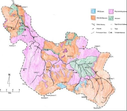
Geological and Geomorphological Evaluation of Melendiz Stream
Ovalıbağ, Bozköy, Asmasız, Sultanpınarı and Çiftlik province are important settlements of Melendiz Stream
Basin. (Figure 1)
The Ihlara Valley part of the Basin is included in the Cappadocia tourism zone. In order to investigate
natural beauty and environmental pollution due to the geological formation of the valley and its surroundings,
with the law enacted in the Official Gazette dated 21.11.1990 and numbered 20702, Ihlara (Cappadocia) Special
Environmental Protection Area (SEPA) was established. According to SEPA, the boundaries of Ihlara Valley
considering its geographical coordinates have been determined. The most northerly latitude of the survey area is
38° 20 '20 "north latitude, the southernmost 38° 13' 10" north latitude, the easternmost 34 ° 19 '30 "east
longitude and the farthest west is 34° 13' 28" east longitude. Ihlara Valley extends from Ihlara town to Selime
town. Selime, Yaprakhisar, Ziga, Belisırma and Ihlara Townships are settlements in Ihlara Valley.
Melendiz Stream basin has a similar shape of triangle which is narrow in the northeast corner and
expanding towards southeast. The mathematical location is between 38° 22 '26 "-38° 07' 56" North Latitudes
and 34° 08 '22 "- 34° 34' 17" East Longitudes.
2. The Aim of the Research
In the research “Melendiz Stream Basin in terms of Geological and Geomorphological Evaluation”,it is
aimed to reveal the geological and geomorphological characteristics of the research area taking into account the
methods and principles of geography science and to make a concrete contribution to the physical planning
decisions of the basin.
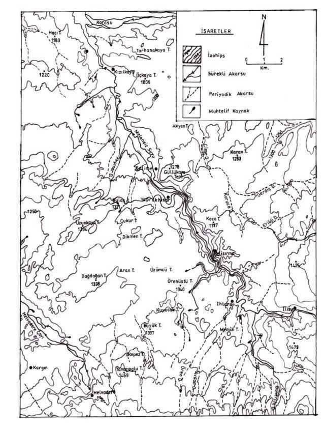
Fig 1. Location Map of Research Area
DOI: 10.9790/0837-2502081929 www.iosrjournals.org 20 |PageGeological and Geomorphological Evaluation of Melendiz Stream
II. MATERİAL AND METHOD
The research consists of 2 main parts under the title of geological and geomorphological features. In
the introduction section; the location and boundaries of the basin, the purpose of the research, materials and
methods, and previous studies are included. In the first part, geological features of the physical geography of the
basin; in the second part, geomorphological features are mentioned.
In terms of Geological and Geomorphological Evaluation, we used the method of utilization of the
documentary data published by public institutions which will contribute to our studies about Melendiz Stream
Basin. Related pages of 1 / 100.000 scale Turkish Topography Map of Turkish General Command of Mapping
and the geology and hydrology reports and maps of the General Directorate of Mineral Research and
Exploration (MTA in Turkish) were utilized in this paper.
After the necessary literature and field studies are completed, the writing phase was carried out by
adhering to the basic principles of thought and explanation techniques of geography such as composing,
dispersion, preparing maps, tables and graphs etc.
In the study named “Geological and Geomorphological Evaluation of Melendiz Stream Basin”, it is
aimed to determine these characteristics of the field and to present the effects of these events locally in a
concrete way.
Investigations made about Melendiz Stream Basin and its surroundings are utilized both while
determining the working method and determining the documents and the results.
The place and limits of the research area within the country have been determined; the basin and its
surroundings have been identified. For this purpose, firstly the geographical position of the basin was revealed
and a location map was prepared. Later, scaled geological cross-sectional shapes were provided and interpreted
to express the geological structure. Topography of the research area was prepared by utilizing the previous
geological studies and 1 / 100.000 scale maps.
The geological and geomorphological characteristics of the Melendiz Stream Basin constitute the
research material. In the determination of these characteristics of the research field; examination and research
results obtained from research sources of various organizations, photographs, reports, statistics, data and maps
were used.
About the geological and geomorphological structure of the field, maps obtained from
IlBank(Constructive Power of Turkey) , GDSHW (General Directorate of State Hydrolic Works) and GDMRE
(General Directorate of Mineral Research and Exploration) and various books and theses were utilized.
The geological and geomorphologic characteristics of the study area were evaluated and in this
evaluation, the results in the final section were developed. The study will conclude with geologic and
geomorphologic features, conclusions and proposals that include the effects of these features on the river basin.
1. Geological Features
Our research area and the surrounding area contain formations formed at different geological times.
Paleozoic and Mesozoic formations are completely covered by Tertiary and Quaternary formations. If the map
of the Melendiz Brook Basin geological map prepared by Ayhan and Papak and simplified by us will be
examined, it will be seen that the field is from generally Tertiary and Quaternary time. Particularly between the
areas of Çiftlik, Ilısu, Selime and Kızılkaya are Quaternary, the remaining large areas are Tertiary aged. (Fig 2)
It is seen that the Alpine orogenic movements on the site formations and the effects of the epirogenic
movements remaining on the surface, which occurred later in the period.
The area of study within the Cappadocia Region is an area where the volcanic activity is dominant. The
main factors that form the geological structure of the basin are: Hasandağı Volcanism, Melendiz Stream and its
branches and the erosion that climate conditions generated.
The Series of Melendiz Stream3 forms the geological structure in the Melendiz Stream Basin. Pliocene
aged volcanics and Quaternary sedimentary units belonging to the Tertiary Senozoic (Tertiary) are available in
the region. (Fig.2)
Şimşek mentioned that Selime tuff and Kızılkaya ignimbrites and among all the volcanic units and
alluvium and travertine were observed to be unconformities. Thus, this unconformity in the cover plate on the
structure Melendiz Stream which is Consequent River is formed. The river, which deepened its bed gradually
and took new arms brought a river system confronting the cover layer.
Investigations on Central Anatolian Tectonism show that the geological units in the basin are located
close to the horizon. This is a sign of that a significant tectonic activity has occurred in the area since tertiary
period so it did not make it tilted.
3
This name called ‘series’ was used by Beekman in 1966.
DOI: 10.9790/0837-2502081929 www.iosrjournals.org 21 |PageGeological and Geomorphological Evaluation of Melendiz Stream
When considered the lithological features,the environment and form of the generation of the formations
in the study area and the relationship between each other; they can be classified as Sedimentary rocks (Çayraz
Formation), Lacustrine Sedimanter-Volkanosedimanter rocks; Volcanic rocks and current formations (Young
Andesite and Basalts, Slag Cones, Traverten, Slope Debris). Mount Göllü, Güzelyurt (Gelveri), Melendiz
Mountain, Mount Hasan and Keçiboyduran Hill form the outgoing points of volcanic rocks in our research area.
The area, when considered its location, formed in palezoic age and it is located on the Kırşehir Massif which
constitutes the first soil parts of Anatolia. However, since the area is completely covered by young units; the
formations of this time remained below.
The period when the formation of Mount Hasan and its surroundings is mesozoic age. The most
important geologic events of this period have occurred in Upper Cretaceous. Due to volcanic events in this
period, they cooled as the lavas filled in the faults and joints which occured in the area. In this way, dikes
consisted. Also, in this period, just like everywhere in our country, the ophiolite series began to take its place in
the area.
Fig 2: Geological Map of Research Area (Complied from the Doğdu,1995)
The second of the marine environment in the area was formed in Tertiary. In addition, discordance is
evident at this time. As a result of orogenic movements, in the area (Çiftlik and surroundings) in the shallow
lakes, the land environment conditions came to the forefront and created neogene places. On eocene
geosyncline, volcanic movemets starting as andesite type in oligocene epoch continued till the end of miocene
period. As a result of volcanism, formations belonging to this period consist of ignimbrite, tuffite, andesite and
tuff. In particular, Göstük ignimbirty is characterized by the formation of small Fairy Chimneys due to the
richness of the pumice stone elements and it is easy to be distinguished from others thanks to this feature of
itself. Due to its easy carving, it is used as an underground store in the region. It is also used as building stone
and coating material in the buildings due to its easy processing and underground water effects and its decorative
appearance. As shown in Table 1, the site is observed in an area of approximately 32.3 km² and more in the
middle of the basin and the east. (Fig 2)
As a result of volcanic movements in Miocene period; due to aggravation of terrestrial environment
conditions, volcanic development starts in Pliocene. With the development of river environment; formation of
tuff, tuffite, sandstone and polluted limestone units is observed in this environment. Selime tuffs (Ignimbrites)
DOI: 10.9790/0837-2502081929 www.iosrjournals.org 22 |PageGeological and Geomorphological Evaluation of Melendiz Stream
are formed at the end of the volcanic activity which was developed again. Following this, as the volcanic
product in the following new period, there are Kızılkaya İgnimbrites as abundant cooling and cracked ash
stream. Melendiz Stream started to be buried in Pleistocene phase due to shallow epigene sedimentation and
enhancement of weightiness. Formations belonging to this period are observed in the area between Yaprakhisar,
Belisırma, Ihlara and Yenipınar; around Bozköy, Azatlı-Sheikhler-Kula and south of Erenler Hill and around
Kitreli (Fig 2).The period formations have been superficial of 47.2 km² area.
As it is all over Anatolia, Melendiz Stream Basin geomorphology is basically shaped in Quaternary.
Climate changes, basin morphology and initial settlements at the beginning of the Quaternary are a significant
influence on soil and vegetation cover. Due to the cold and arid climatic conditions in the last glacial period, the
formation of the soil has stopped in a considerable extent and the steppes have become the major vegetation
cover. Depending on freeze-thaw events, Koluvial deposits seen on the slopes as sludge streams which were
descending to the surface of the plain formed thick slope deposits. This can be seen in farm piedmonts.
During the Holocene period, which is also named as today’s world and the last period of the
Quaternary, precipitation and temperature have increased and the present climate conditions have begun to
occur. In this period, depending on the increase in precipitation, the subsidence of Melendiz Stream whose
corrosion revived formed itself. The elements that characterize the subsidence are the existing terraces and
fillings in Ihlara Valley and the Piedmont terraces around Çiftlik. This can be seen on the elevations up to 70 m
from the base of the valley. With the development of the side arms, the basin began. We can say that Melendiz
Stream is a stream that is formed by the Quaternary. In addition, calcification process started in the soil.
The latest units in the study are the Quaternary aged terraces and alluvial deposits consisting of gravel
and clay deposits in river valley. Şimşek mentioned that, deep and shallow circulating thermal waters along
newly formed fractures, which developed with regard to Mount Hasan, reached the surface and they formed the
travertines around Zığa province. Formations belonging to this period have a surface area of 20.4 km2 (Fig 1).
1.1 Tectonism
In our research, it is very difficult to express tectonism. The most important reason of this is that the
young units that have originated during the terrestrial period in Tertiary, (young volcanic rocks and lacustrine-
terrestrial units)spread over large areas and covered tectonic components, many geological data remain hidden
under cover units. However, the order in which the cones that provide volcanic activities are arranged in general
direction is an indication of important tectonic lines. This line, which is Northwest-Southeast directional, can be
considered as a directional of faultline that is regarded as covered with volcanism components in our study area.
Aksaray faultline that is along east and outside of our area is also in this direction. Gelveri faultline that is NE-
SW directional and outside our study area but becoming neighbour of the area and Çayraz Formation Faultine
that is north of Mamasun Dam and East-West directional are available. These faultlines took shape with the
volcanism that is in the first period.
In the geomorphological units that are indicated in the Geomorphology map of MTA, it is stated that
there is a NW-SE directional, buried faultline in Ihlara Valley. There also is a faultline that is northwest of the
basin, active in Ihlara Valley and forms the Ziga thermal source. Şimşek expresses that this faultline is a normal
pulsating one.
The scientists who search about Middle Anatolia Tectonism such as Beekman, Lahn etc. emphasised
that there were an old ocean and a north-dipping subduction zone before the Paleocene, the relevant ocean
begins to close till the end of this period, as a result of a continent-continent collision between the Arab-African
plate and the Anatolian plate, volcanic products reaching the earth from the tension cracks developed due to
compression occured after oceanic crust in the subduction zone, which once existed, was consumed in the upper
mantle.
1.1.1 Volcanism
A significant part of Turkey has undergone a period of volcanic eruption that began in Miocene and
continued in the Quaternary. As a result of volcanism, Anatolia was covered with volcanic products
(Göçmez,1997; 64). The research area is located in the Central Anatolian Volcanic Region. Young Tertiary-
Quaternary, aged volcanism was active. This volcanic activity is a result of that the continent-continent collision
between the Arab-African plate and the Anatolian plate and this is a common view among all the geologists.
The volcanisms called Mount Göllü, Mount Hasan, Keçiboyduran, Mount Kulaklı which are young volcanites
are the volcanic activities in our research area.
In our research area, as Lahn, Sür and Atalay mentioned; volcanism started with ignimbrite eruptions in
Pleogene- Quaternary period, ash, tuff and aglomera followed this and it ended with basalts. According to
Beekman, Batum , Şengör, and Yılmaz; the first products of the volcanism are dacitic tuffs that spread over a
wide area with violent explosions in Upper Miocene and some of this material was precipitated in local small
lakes that developed under terrestrial conditions. Then volcanoes re-intensified and formed ignimbrites.
DOI: 10.9790/0837-2502081929 www.iosrjournals.org 23 |PageGeological and Geomorphological Evaluation of Melendiz Stream
Towards the end of the Upper Miocene, this acidic volcanism formed andesitic lava and agglomerates. Since
Lower Pliocene, volcanoes have been again effective in the obsidian currents, together with ignimbrites;
towards the end of Upper Pliocene it formed basic lava flows and slag cones by acquiring basic properties.
Quaternary basalt made Pyroclastic materials such as tuff, slag, ash, volcano bomb, and ignimbrite
common in the area by continuing in volcanic species (Atalay,1987;:36). In other words, the economic products
of this volcanism are pumice (Kitreli), Perlite (Farm), Diatomite (Bozköy, Duvarlı, Ovalıbağ).
The rich obsidian deposits formed in places where Tertiary and Quaternary volcanism are effective are
observed in the farm district and northern part of our research area.
Güzelyurt (Gelveri) in the east, Mount Hasan and Keçiboyduran in the southeast, and Melendiz
Mountain in the south form the places where the volcanic rocks reach to the basin. Sür, in 1972, in his report,
volcanic activities in the study area and its surrounding separated into two large groups; Miocene-Lower
Pliocene volcanism and Upper Pliocene-Quaternary volcanism.
In the first group of volcanism, volcanic stones including including lavas, ignimbrites and tuff
intercalated layers, composed of andesites and dacites form a group. Shapes are formed by volcanic mountains,
ignimbrite-based lava platelets and tuff interbeds (Neogene Topography).
In the second group volcanism, large scale completion of the formation of subsidence can be
summarized as the manifestation of central eruptions as basalt and partly as andesite lavas in certain lines, the
formation of ash and pyroclastic cones, maars, explosion calderas near volcanic mountains, the settlement of the
new volcanic material onto the old and worn volcanic mountains(Sür,1972;37). In the field of research, Mount
Hasan, Melendiz Mountain, Keçiboyduran, Mount Göllü and Mount Kulaklı volcanoes have been influential.
2. Geomorphological properties
Just as in Anatolia, the geomorphology of the Melendiz Stream Basin is also shaped in the Quaternary.
Geomorphological structure was first formed by volcanic activity. Influenced by the atmospheric events that
took place in the volcanic structure; complex valley forms, cliffs, crevices, caves, flat or pointed rocky hills
formed close to each other.
At the beginning of the morphological components, which are noticed in the study area and its
surroundings, are the hilly-mountainous areas, the piedmont plains which we see to the east of the Çiftlik district
and the Ihlara Canyon Valley. The Fairy Chimneys, horizontal formations (terrace sets), covert appearance of
Mount Hasan ashes, thin but widespread stretch of travertines along fault lines formed the current geological
structure of the erosion search area whose influence has been seen in the field.
The lithologies in the area formed by volcanic ash and tuff under the effect of water have been eroded
in different forms over time due to the effect of surface waters. Interesting rock formations and surfaces have
also emerged on the slopes of Ihlara Canyon Valley due to the effect of water and wind erosion.
2.1. Hilly and Mountainous Areas
The highest reliefs of mountainous and hilly areas surrounding the basin form mountains and hills in
the south and southeast of the basin. Bozdağ, Keçiboyduran Hill, Kılıç Hill, Kuşsivrisi Hill, İtuymaz Hill and
Bozdede Hill form these elevations. (Fig. 3) The southwest of the basin is a follow-up of the Mount Hasan
volcanic mass and its southeast is a follow-up mountain of Melendiz Mountain volcanic mass.
Bozdutaş Hill, Boz Hill, Sibik Hill and Dağbaşı Hill which present the structural continuity of Mount
Göllü and Çınarlı volcanoes form the east of the basin (Fig.3).
The elevated basin in the north made the basin look like a plateau with the mountains which form its
south complex. Kulaklı Hill, Şahin Castle Hill, Kavutkaya Hill, Kişlebaşı Hill, Kabak Hill, Tüllüce Hill, Kıran
Hill and Asar Hill formed these elevations (Fig.3).
Kızıltepe, Boztepe, Erenler Hill and Mustafa Hill, which are located in the inner parts of the basin,
have also created a throat view of the Melendiz Stream. In addition, Çaykara Hill, Aşağı Hill, Üçhüyük Hill,
İkiz Hill and Memili Hill basins form other elevations in the basin; and Şimşir Hill, Tavşankalesi Hill, Büyük
Hill, Kuyucak Hill, Doğdağan Hill and Uzunkaya Hill constitute the elevations in the western part of the basin
(Fig.3).
In our research, in general, the elevation is increasing from northwest to southeast. The elevation show
changing different values between 1250m and 2750m. Especially the middle section of the basin (Çiftlik
province area) forms the largest elevation step sequence within the entire basin regarding its value between
1500-1750 m (Fig.4).
On these elevations flood ravines (gullies) and slope adaptation are detected. Thus, thanks to the
fluvial activity, the most important role in the contouring of the field is reflected. It causes serious hazards
especially in the elevations established in the skirts of the residential units. The settlements are under threat
because of the mudflows and rock rolls. In Selime Village, Belisırma and Yaprakhisar, local governments
should take urgent precautions.
DOI: 10.9790/0837-2502081929 www.iosrjournals.org 24 |PageGeological and Geomorphological Evaluation of Melendiz Stream
2.1. Piedmont Plains
The research area is seen as the alluvial filling area around the Çiftlik district. Alluvial accumulation
forms form piedmont plains by rising to the east with a low slope. The elevation difference here is
approximately 60 meters. It is seen as a subsidence field surrounded by orographic heights like Kale Hill,
Üçhüyük Hill, Mustafa Hill, Boz Hill, Erenler Hill and Mount Göğüs. Çardak Village constitutes the part where
the elevation is the least. This part of the basin is alluvial lowland of 50 km2. Emre stated that it is usually
between 1-5 meters depending on the localization of the alluvium thickness and the alluviums were streamed
towards the edges.
Under the alluvions, Mount Hasan Ash Formation is expanded. This formation, which was deposited in
the lacustrine environment, can be observed till the 1550 m level. This situation shows us that there is a lake at
the bottom of the field during the subsidence of Mount Hasan Ash Formation and this lake has risen to 1,550
meters (Emre,1991; 56). Within this alluvial field, Melendiz Stream draws small meanders and moves away
from the area with the Çardak Strait.
2.3. Ihlara Canyon Valley
One of the important geomorphological components in the study area is the Ihlara Valley which is
located in the northwest of the area and it contains various geomorphological components. Ihlara Valley which
is 14 km long and includes Selime, Yaprakhisar, Belirmakma and Ihlara towns is an epigenetic and canyon
valley. It has an average depth of 80 m and is 100 or 120 m deep from place to place. In the formation of the
Ihlara Valley, regional uplift movements, along with broken lines and systems, were effective.
The first process that comes to mind in the formation of the valley, it can be considered that in Lower
Quaternary the basin has become a lake with the lava settlement in the Upper Pliocene, it is a lake foot of the
Çardak Strait which looks like a
threshold and this area is split into the valley of Melendiz Stream. However, no morphological data
was available to interpret this process. The Melendiz Stream, which was established on the old Mount Hasan
Ash Formation in the lower Quaternary, was developed as a submerged (epigenetic) form in the below
ignimbrite, basalt and andesites (Emre,1991;62). Near it, there are large areas of basalt and andesite-density
lavas emerging from Mount Hasan, an old volcano. As a result of the collapses coming from the neogenous and
quaternary formations, cracks in the field occurred. The Melendiz Stream, which is called Peristremma, which
emerged from Mount Hasan and Melendiz Mountain in the early ages and which means Cappadocia Ridge, also
emerged as a Canyon Valley in the course of deepening by forming a bed in itself (Pic.7). The valley is 1220m
altitude from sea level. (Fig.5) In Neogene and Quaternary, the tectonic movements causing the volcanic
eruption of the Mount Hasan caused collapsing of the areas where the shades of gray, green and brown are
dominant in some places and covered with rocks that are crumbling with coarse grains and soft tuffs. The
Melendiz Stream that goes along the Ihlara valley is also the result of this kind of collapse and
DOI: 10.9790/0837-2502081929 www.iosrjournals.org 25 |PageGeological and Geomorphological Evaluation of Melendiz Stream
Fig.3 Melendiz Stream Basin Topography Map.
Fig.4 Elevation Distribution of Melendiz Basin.
has gained a greater depth by carving the floor of the canyon valley. It has descended to 100 or 120 m depth
from place to place (Fig.5).
The Ihlara valley exhibits a curvature in the direction of East-West and Northeast and Southwest. The overall
extension of the valley is the SE-NW direction. The curvature in this direction corresponds to the directions of
the fracture dominated on the Kızılkaya ignimbrites. This indicates that the most intense fracture system is in the
NE-SW direction.
DOI: 10.9790/0837-2502081929 www.iosrjournals.org 26 |PageGeological and Geomorphological Evaluation of Melendiz Stream
Fig.5 Topography Map of Ihlara Valley and its Surrounding.
Because vertical slopes in the valley are composed on the hard and durable Kızılkaya ignimbrites, it
caused interesting appearences and steeps by raising the slope. Kızılkaya ignimbrites are observed as mesa
shaped patterns like platform. Tuff and volcanic ashes form easily eroded (badlands) topography. The elevations
around the valley are formed by Güllükaya Hill, Koca Hill, Memili Hill, Örenüstü Hill, Üzümcü Hill, Dikmen
Hill,Çukur Hill and Bulaş Hill. The average heights of these peaks are around 1300 m. (Fig 5).
2.4 Travertines
There are travertine masses in the Ihlara Valley and around Yaprakhisar Village and Zığa Hamamı.
Even though the formation of travertine continues in places where hot water outlets are observed, there is no
proven active fault line in the area. Despite the shallow epirogenic uplifts occurring in Neogene and Quaternary,
the river basins that began to be subsided were quite on the skids. At the end of the tectonic movements causing
the eruption of the Mount Hasan volcano, a large volcanic surface covered the environment. During the same
movements, natural hot water and sediments gushing out of the broken line caused by the pressure and
temperature of the limestone formed the travertine in Ziga thermal between Yaprakhisar and Ihlara.
In our research area, the area where a large number of hot water outputs are observed is the field
between Zığa Hamamı and Ihlara Valley. It shows itself as a travertine ridge along the east of Yaprakhisar.
Karabacak stated that travertine is appeared as eroded mantle.
2.5 Erosion
The main factor determining the morphology of Ihlara Valley in the Melendiz Stream Basin is the
erosion which still continues today besides geological activities. Surprising natural items that attract people who
live constantly in the region can be seen any time. Since our investigation area is covered with tuffs and its plant
cover is composed of poor grass increased the erosion.
The other factor increasing the erosion is human. The area has been an important settlement since the
early ages. Rock-carved settlements and rock carved churches are very common in the area. There are over one-
thousand rock-carved settlements and churches only in the Ihlara Valley. In this case, the slopes are processed
by human hands and resistance to geological erosion is broken.
In our research, geomorphological shapes such as Ihlara Canyon Valley and Farm Piedmont Plain have
emerged as a result of natural and accelerated erosion that took place in millions of years.
On the elevations in our research area, surface erosion which is one of the types of the river erosion is
observed in Selime village and clay erosion which is one of the types of raindrop erosion is observed
surrounding the village. In particular, clay erosion causes serious dangers in the elevations that are formed in the
skirts of the settlements. Due to mudflows and rock rolls, the settlement units are in danger. During severe rain,
as a result of rain dripping strongly against the soil which is devoid of vegetation cover clods are broken and
structure is harmed. So the soil becomes muddy. This clay mainly consists of thin soil grains (clay and alluvion)
that the rain drops plucked. The resulting clay layer moves along the sloping surface. A river bed erosion is seen
in Melendiz Stream bed. The material that the river sweeps in a bed of its own strength is carried along with the
water.
This is a transport phenomenon with a wear and drift that occurs at the edges and bottom of the river
bed. We observe this situation in the flow direction of the Melendiz Stream in Yaparakhisar.
The erosion in Ilısu and Yaprakhisar is remarkable in the research area. Erosion in the mentioned areas
characterizes itself as the formation of Fairy Chimneys. This situation is also triggered by over-rated vegetation
damage on the field.
2.6. Fairy Chimneys
We can observe Fairy Chimneys which are a special erosion form of Badlands rellef in the research
area. The tuffs which formed as a result of volcanic eruption that affects structural character of the environment
are worn with wave,erosion, and other natural factors; they formed Fairy Chimneys which can be observed in
different colors and shapes in Selime,Yaprakhisar and Ilısu.
The formation of Fairy Chimneys occurred in rainy phase in Quaternary. The slopes covered with tuffs
in the rainy phase were easily formed by abrasion. Thick tuff covers forming sloping surfaces and torrential rain
falls play a major role on Fairy Chimneys which are one of the shapes forming as a result of fluvial erosion. The
lithology of the region they formed is widely composed of volcanic materials (tuff, aluvion, marl, clay etc).
Thick tuff mantle reaching 100 m in Selime and Yaprakhisar becomes its thinnest form near Göstük by
getting thinner towards north and west. These tuff mantles enabled formation of Fairy Chimneys between
Selime and Yaprakhisar, right shores of Melendiz Stream.
Selime fairy chimneys are similar to Urgup tuffs which placed 50km northwest of the area and Urgup
Fairy Chimneys in terms of structure and composition.
DOI: 10.9790/0837-2502081929 www.iosrjournals.org 27 |PageGeological and Geomorphological Evaluation of Melendiz Stream
When it is given a look to these interesting natural wonders, it gives the impression of a town which is
decorated with towers. Fairy Chimneys attract the attentions with its two pieces called column and hat. The hat
is a hard rock mass such as andesite and basalt; however some of them are without a hat. Many of them were
carved in ancient and medieval times and used as monasteries, churches and houses. For this reason, the tourists
often visit here and this situation makes our research area a tourist attraction. However, due to the fact that local
people unconsciously established their dwelling in these areas and necessary tourism investments were not made
the area loses its charm day to day.
2.7. Terrace sets
The subsidence of Melendiz Stream is seen in the basin since pleistosen. The factors that characterize
subsidence are the present terrace sets and fillings on the valley. This can be seen on the 70 m elevations from
the bottom of the river.
As a result of that Melendiz Stream changes its bed in accordance with the regional tectonics; we watch
the old river alluviums on the slopes on various levels throughout Ihlara Valley. In these levels, river sediments
are seen in pebble, sand and clay sizes. The plains of abrasion are typical at non-sedimentary levels. The largest
terrace outcrops throughout the valley is southwest of Ihlara (Gülkal,1999;30).
NE-SW directional crack densities played an important role in the course of the deepening the valley
by Melendiz Stream. The most typical one of the forms that the valley is deepened by Melendiz Stream over
time is Sarıoğlan terrace set and it presents a very typical shape in terms of exposure.
The traces are also considered by the local people as important agricultural sites. This activity, defined
as terraced agricultural technique, facilitates the cultivation of grain and horticultural cultures.
III. RESULT AND DİSCUSSİON
Melendiz Stream Basin, located in Lake Tuz Closed basin, is an area of 565,2 km2 and narrow at its
northwest corner. It shows subsidenced field which has a triangular pattern extending into the southeast
direction.
Main factors forming the geological structure of the basin: Mount Hasan volcanism, Melendiz Stream,
the headwaters which feed that,and the erosion that climate conditions made. The geomorphology of the
Melendiz Stream Basin is shaped in the Quaternary. Melendiz Stream, by continuing its flow after the Çardak
Strait in the lava plateau, forms the Ihlara Valley within the plateau area. Major morphological factors drawing
attention are mountainous-hill areas, Piedmont plains which we see in the east of Çiftlik district, and Ihlara
Canyon Valley. Fairy Chimneys –the shapes which are unique to terrace sets- , the covered appearance of ashes
of Mount Hasan, thin but common extension of the travertines along the fault lines formed current
geomorphological structure of erosion research area whose effect is observed in the area. The exposure of the
basin to tectonic movements allows the formation of hot water discharges along the fractures and travertine.
Since Melendiz Stream Basin is located in the Konya Closed Basin, it is an endorheic area. There are many side
branches, spring and seasonal streams.
As a result of the geological and geomorphological characteristics of the research area;
1. It allows the use of scenery for tourism purposes. Hot water exits are a welcome compromise of geological
construction in health tourism, thanks to the Ihlara Valley formed by the burial of the Melendiz Stream in
the lava plateau, it brought economical movement as health (medical,wellness ) and belief tourism.
2. The geological building elements Kızılkaya and Göstük ignimbrites are used as building materials in
construction sector. This situation causes another economic activity on the area.
3. Hasandağı ash formation is used by local people in making molasses
4. Materials of basaltic slag cones are used as gravel material in road construction.
5. The fields where alluvium accumulation of Melendiz Stream is used as fertile garden and agricultural land.
6. As a result of using the area efficiently, it is inevitable that it will bring crucial values to the area.
However; the area is utilized unconciously and the natural system are worn out. In order to prevent this:
1. Over-use of the geological elements of the area should be avoided because many quarries are accelerating
erosion.
2. The public authorities in the area should be supported in terms of qualified staff.
3. Thereby stream rehabilitation work is done by State Hydraulic Works, Amateurish utilization conditions
should be avoided.
4. Especially in Ilısu and Sivrihisar, an urgent measure plan should be taken for the economic evaluation of
the thermal exits and it should be brought into action.
5. Destruction of vegetation cover must be avoided so erosion will be prevented.
6. In the area, rehabilitation works against erosion should be urgently started.
DOI: 10.9790/0837-2502081929 www.iosrjournals.org 28 |PageGeological and Geomorphological Evaluation of Melendiz Stream
REFERENCES
[1]. Ardos, M. (1995).Türkiye Ovalarının Jeomorfolojisi Vol I-II. Çantay Kitabevi. İstanbul.
[2]. Ardos, M. (1996).Türkiye’de Kuaterner Jeomorfolojisi. Çantay Kitabevi. İstanbul.
[3]. Arıbaş, K.(1995). Gökçeköyü ve Çevresinin Coğrafi Etüdü. Selçuk Univ. Sos. Bil.Enst.(Yayınlanmamış
Yüksek Lisans Tezi). Konya.
[4]. Arıbaş, K.(1995). Aksaray Ovası Beşeri ve Ekonomik Coğrafyası.Selçuk Univ. Sos. Bil.Enst. ( Doktara
Tezi). Konya.
[5]. Atalay,İ.. (1987). Türkiye Jeomorfolojisine Giriş. Ege Üniv. Edebiyat Fak. Yay. No:9,
[6]. 2nd Ed. İzmir.
[7]. Atalay,İ.. (1992). Türkiye Coğrafyası. Ege Üniv. Basımevi, İzmir.
[8]. Atalay,İ. (2005). Kuvaterner’de İklim Değişmelerinin Türkiye Doğal Ortamı Üzerindeki Etkileri.
[9]. Türkiye Kuvaterner Sempozyumu. İTÜ Avrasya Yer Bilimleri Ens. İstanbul.
[10]. Atiker,M.(1988).Melendiz Suyu Kanyonu yada Ihlara Vadisi.Bilim ve Teknik Dergisi, V.21, i.244,pg:44-
47.Ankara.
[11]. Ayhan,A.(1998). Aksaray, Taşpınar, Altınhisar, Çiftlik, Delihebil Arasının Jeolojisi. MTA Genel
Müdürlüğü yayınları. Ankara.
[12]. Baylak, H.M.(2007)”Fiziki Coğrafya Özellikleri Bakımından Melendiz Çayı Havzası’nın
İncelenmesi.”Yüksek Lisans Tezi. Selçuk Üniversitesi Sosyal Bilimler Enstitüsü.
[13]. Binal,A.(1996).Aksaray-Ihlara Vadisindeki Volkanosedimenter Kayaçlarda Görülen Duyarsızlık
Mekanizmalarının Araştırılması.Hacettepe Üniv. (Yüksek Mühendislik tezi). Ankara.
[14]. Doğdu, M.Ş.(1995). Melendiz Havzası (Aksaray) Hidrojeoloji İncelemesi.Ankara. DSİ.(1956). Mamasun
barajı Avam projesi. Ankara.
[15]. Emre,Ö.(1991).Hasandağı-Keçiboyduran Dağı Volkanizmasının Jeomorfolojisi. İst. Üniv. Deniz
Bilimleri ve Coğrafya Enstitüsü ( Doktara Tezi).İstanbul.
[16]. Göçmez,G. (1997). Aksaray Sıcak ve Mineralli Su Kaynaklarının Hidrojeoloji İncelemesi. Aksaray
Valiliği Yay. Aksaray.
[17]. Gülkal, Ö.(1999). Ihlara (Kapadokya) Özel Çevre Koruma Bölgesi ve Yakın Çevresi Örneğinde;
Koruma-Kullanma Dengeli Planlamaların Oluşturulmasında Kriterlerin Saptanması. Çukurova
Üniversitesi (Doktora Tezi). Adana.
[18]. Karabacak,V.(2002). Ihlara Vadisi Civarındaki Traverten Oluşumları ve Tektonik Önemleri. Eskişehir.
[19]. Kaya,C.(1986). Aksaray Ihlara Sahası Jeotermal Enerji Aramaları Jeofizik Etüdü. Orta Anadolu 2. Bölge
Müdürlüğü Print No:866. Ankara.
[20]. Ötüken,S.Y. (1990). Ihlara Vadisi. Kültür Bakanlığı Yayınları No:1126,Tanıtma eserleri No:33. Ankara.
[21]. Pehlivan,D.(1990). Ihlara Dolaylarının Jeolojisi ve Hidrojeoloji İncelemesi. Konya.
[22]. Sür, E.(1972). Türkiye’nin, Özellikle İç Anadolu’nun Genç alanlarının Jeomorfolojisi. Ankara Ünv. Dil
ve Tarih-Coğrafya Fak. Yay. No:223. Ankara.
[23]. Şimşek, Ş. (1997). Ihlara Özel Çevre Koruma Bölgesi’nin Jeolojisi ve Bölgede Yer alan Termal
Kaynaklarının Hidrojeolojik ve Hidrojeokimyasal Araştırması ve Korumayaİlişkin Önerileri. Aksaray
Valiliği Yay.Aksaray.
Basin. " Geological and Geomorphological Evaluation of Melendiz Stream." IOSR Journal of
Humanities and Social Science (IOSR-JHSS), 25(2), 2020, pp. 19-29.
DOI: 10.9790/0837-2502081929 www.iosrjournals.org 29 |PageYou can also read