Linking the Kangra piggy-back Basin with reactivation of the Jawalamukhi Thrust and erosion of Dhauladhar Range, Northwest Himalaya - Episodes
←
→
Page content transcription
If your browser does not render page correctly, please read the page content below
335
       Article

by Vikram C. Thakur1 +, M. Joshi2, N. Suresh1

Linking the Kangra piggy–back Basin with reactivation of
the Jawalamukhi Thrust and erosion of Dhauladhar Range,
Northwest Himalaya
1
 Wadia Institute of Himalayan Geology, 33 GMS Road, Dehradun 248001, Uttarakhand, India; +Email: thakurvc12@gmail.com
2
 G. B. Pant National Institute of Himalayan Environment and Sustainable Development, Sikkim Regional Center, Pangthang, Gangtok
737101, Sikkim, India;

(Received : 19/08/2018; Revised accepted : 23/05/2019)

https://doi.org/10.18814/epiiugs/2020/020020

    A dynamic coupling between climate-induced erosion               Arita, 1991; Robinson et al., 2006). The principal thrust systems are
and tectonics is envisaged for the growth of the Himalaya.           the Main Central Thrust (MCT), the Main Boundary Thrust (MBT),
                                                                     and the Himalayan Frontal Thrust (HFT). Thickening of the crust in
The Dhauladhar Range (NW Himalaya), between the Beas                 response to thrusting is considered largely responsible for the growth
and Ravi rivers, shows large altitude variation along the            including uplift of the Himalaya (DeCelles et al., 2001; Yin, 2006;
regional trend from southeast to northwest. The altitude             Robinson et al., 2006). It is now recognized that there is a feedback
rises between 5000 m and 4000 m in the eastern part and              from climate and dynamic tectonic coupling in the growth of the
                                                                     Himalaya (Beaumont et al., 2001; Wobus et al., 2003; Thiede et al.,
decreases between
336

Figure 1. A) SRTM image shows physiographic-tectonic setting
of the Dhauladhar-Kangra Basin. Altitude of Dhauladhar Range
decreases, southeast to northwest, from 5000 to 2800 m. Kangra
and Palampur fans constitute the K-Basin. The Kangra fan lies
between the D-Range and the Siwalik Range. Insets: Location of
Figs. 3 and 6. B) Cross-sections A-B and C-D indicated in Fig.
1A. a) Cross-section A-B across eastern part of the D-Range. b)
Cross-section C-D across western part of the D-Range. Legend:
1-Indian crust, 2-Chamba sequence, 3-Dhauladhar granite, 4-
Salkhala/Haimanta Formation, 5-Panjal Imbricate Zone (Lesser
Himalayan formations), 6-Dharamsala Formation, 7-Lower,
Middle, Upper Siwaliks sequence, 8-Middle Siwalik Formation,
9-Late Quaternary Kangra Basin. Geology is after Thakur (1998).
(c) Cross-section, x-y, between the Jawalamukhi Thrust and the MBT, location shown in Fig. 2Bb (enlarged), extracted from the northern
part of the balanced cross-section of Power et al. (1998). Legend: a- Pre Cambrian basement, b- Lower Dharamsala, c- Upper Dharamsala,
d- Lower Siwalik, e- Middle Siwalik, f- Upper Siwalik, g- Late Quaternary sediment (thickness exaggerated).

of strath terraces implies uplift of the hanging wall of the JT,           in the region. The principal thrusts, occurring along the southern base
resulted due to slip over the fault in response to its reactivation. The   of the D–Range front (Fig. 1B), were drivers for its uplift. The AFT
geological setting of this basin on hanging wall of the JT and the         and ZHe dating across the transect from Dhauladhar, Pir Panjal and
OSL dates of geomorphic surfaces in the basin and strath terraces          Higher Himalaya indicate about three times mean higher erosion rates
may suggest a climate–tectonic linkage between aggradation and             over the frontal Dhauladhar Range in comparison to the hinterland
incision.                                                                  ranges of the Pir Panjal and the Higher Himalaya (Deeken et al.,
                                                                           2011).
                                                                                South of the D-Range, the foreland basin constitutes ~80 km wide
Geological Setting                                                         belt of foreland propagating fold–thrust system between the MBT
    The Kangra Basin is a post–Siwalik intermontane basin, and lies        and the Himalayan Frontal Thrust (HFT) (Karunakaran and Rao, 1979;
on northernmost part of the Siwalik foreland basin in the Kangra re-       Powers et al., 1998). South of the D-Range front and the MBT, the
entrant (Fig. 2A). The basin is flanked to the north by the D-Range        Paleocene–lower Eocene Subathu and Oligocene Dharamsala
which rises abruptly from the Siwalik foreland (Fig. 1). The southern      formations are thrust over the Neogene Siwaliks along the Palampur
base of D–Range is demarcated by the closely-spaced Main Central           Thrust. Further south, the Middle and Upper Siwaliks constitute a
Thrust (MCT) and the Main Boundary Thrust (MBT) (Fig. 1B)                  partially eroded anticline, and to the north a broad and wide synform
(Thakur, 1998). The D-Range is made of lower Paleozoic granite             of the K-Basin. These are thrust over the Lower Siwalik along the
massif that extends in NW-SE direction along regional strike and           Jawalmukhi Thrust (JT) (Figs. 2A, B). The seismic reflection profile
emplaced as a concordant body within the Salkhala or Haimanta              across the Kangra re-entrant shows the JT branching off from the
Formation. The Salkhala Formation, constituting the base of the            decollement (Powers et al., 1998), which is equivalent to the Main
Chamba nappe sequence, is thrust over the narrow belt of the Lesser        Himalayan Thrust (MHT).
Himalayan formations along the MCT, locally called as the Panjal
Thrust (PT). The Lesser Himalayan belt is thrust over the Cenozoic
Siwalik foreland basin along the MBT (Fig. 1B; Thakur, 1998).
                                                                           Geomorphic surfaces
Reconstruction of exhumation history from the eroded detritus in the            Three geomorphic surfaces are recognized within the Kangra fan
Kangra reentrant Siwalik strata reveals that the Salkhala Formation        in the K-Basin: a) Ridge top surface, b) Middle surface, and c) Lower
and the Lesser Himalaya sequences were exhumed to the surface by           surface (Fig. 3). There are isolated ridges trending NNE-SSW,
~17 Ma and 9-6 Ma respectively (Najman et al., 2009). These age            separated by wide depressions filled in by the intervening fans of
constraints imply the timing of the emergence of the MCT and MBT           later generation. The distal part of the fan is characterized by relatively

                                                                                                                                         March 2020
337

                                                                                                        planar surface of the Kangra valley
                                                                                                        that abuts against the Siwalik Range
                                                                                                        to the south.

                                                                                                        Ridge top surface
                                                                                                            The 900-1300 m elevated NNE-
                                                                                                        SSW trending isolated ridges, made
                                                                                                        of debris flow deposits, representing
                                                                                                        the highest geomorphic surface, are
                                                                                                        termed as the Ridge top surface (Fig.
                                                                                                        3). The Dharamsala, Kuned, Naina
                                                                                                        Devi and Siund are the prominent
                                                                                                        ridges, representing the remnants of
                                                                                                        incised older fans. In places, where
                                                                                                        the incision is deep, the debris flow
                                                                                                        is underlain by consolidated Upper
                                                                                                        Siwalik Boulder Conglomerate at the
                                                                                                        base      or    with      intervening
                                                                                                        unconsolidated boulder bed of fluvial
                                                                                                        origin. These are observed at the
                                                                                                        Baner river incising the Siund ridge,
                                                                                                        the Sarah stream incising the
                                                                                                        Dharamsala ridge, and the Nod
                                                                                                        incising the Kaned ridge. The ridges
                                                                                                        are composed of two types of
                                                                                                        lithologies: (a) granite debris flow
                                                                                                        consisting predominantly of cobbles
                                                                                                        and boulders of the Dhauladhar
                                                                                                        granite in sand matrix, dispersed with
                                                                                                        coarse white fresh feldspar laths and
                                                                                                        large to out-size granite boulders, >10
                                                                                                        m across, occurring on the surface or
                                                                                                        within the debris flow, (b) mud flow
                                                                                                        debris of angular-subangular, poorly
                                                                                                        sorted pebble to boulder clast of
                                                                                                        sandstone, slate, quartzite and
                                                                                                        occasional granite in brownish matrix
                                                                                                        of silt and mud.

                                                                                                        Middle surface
                                                                                                            The areas between the raised
                                                                                                        ridges are occupied by the coalescing
                                                                                                        fans that extend from the mountain
                                                                                                        front to the distal part. The fans
Figure 2. A) Regional geological map of Kangra re-entrant. MCT-Main Central Thrust, MBT-Main            deposits are composed of clast to
Boundary Thrust, PA-Paror Anticline, LS-Lambagaon Syncline, BA-Balh Anticline, BS-Balaru                matrix-supported, unsorted to poorly-
Syncline, DA-Dehra gopipur Anticline, DUS-Dumsa syncline, ST-Soan Thrust, HFT-Himalayan                 sorted granite boulders with some
Frontal Thrust. Legend: 1-Alluvium, 2-Alluvial fan deposits in dun basins, 3-Frontal Siwalik Range      phyllite and sandstone. Very large
(Upper, Middle Siwaliks) 4-Hinterland Siwaliks (Lower, Middle, Upper), 5-Dharamsalas, 6-Subathus,       outsize (3-10 m diameter) granite
7-PIZ: Panjal Imbricate Zone (Lesser Himalaya formations), 8-High and Tethys Himalayas. Map             boulders occur on the fan surface and
modified after Powers et al. (1998) and Thakur et al. (2014). B) Balanced cross-section across Kangra   along the channels of the southwest
re-entrant based on A-B line in Fig. 1A, showing major structures, estimated shortening rates on the    flowing streams, whereas medium- to
thrust faults. 1-Upper Siwalik, 2-Middle Siwalik, 3-Lower Siwalik, 4-Upper Dharamsala, 5-Lower          small-size clasts are embedded in sand
Dharamsala, with thin Subathu, 6-Pre–Cambrian-Cambrian metasdimentaries (Vindhyan Group),               matrix with coarse grained quartz and
7-Pre–Cambrian Crystalline basement LS-Lambagaon Syncline, BA-Balh Anticline, BS-Balaru                 fresh feldspar grains. The fans are
Syncline, DA-Dehragopipur Anticline, DUS-Dumsa syncline (after Powers et al., 1998). Shortening         largely debris flow deposits together
rates of thrusts taken from Thakur et al. (2014).                                                       with subordinate fluvial gravels along

Episodes Vol. 43, no. 1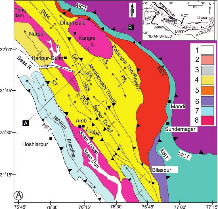
338

the stream channels and deposited in high energy condition. In the        volcanics in sand matrix or clasts-supported unit. This unit
middle of the basin, the regional slope surface is uneven with average    unconformably overlies the Upper Siwalik Boulder Conglomerate
slope of 5º to 10º and covers the intervening areas between the ridges.   and, in turn, overlain with the granite boulder-bearing debris flow
The granite boulders-bearing debris flow extend right up to distal        deposit. The clast composition and character of the boulder bed gravels
parts of the fans, and its deposits overlie uncomfortably the eroded      suggest that these are largely derived from the Upper Siwalik Boulder
consolidated Upper Siwalik Boulder Conglomerate at several                Conglomerate.
places.

                                                                          Kangra Basin
Lower surface
                                                                              The Kangra Basin (K–Basin) is developed within the northern
    Nearly the flat valley surface of Kangra valley (basin) extends on    part of the Siwalik foreland basin in the Kangra re-entrant. It has a
both sides of the National Highway (NH-20) from near Shahpur              unique tectonic–physiographic settings, as the basin lies south of the
through Gagal, Kangra, Nagrota and further east towards Paror and         eastern Dhauladhar Range of the Lesser Himalaya that rises to 4000–
Paprola. The lower surface is flanked to the south by the Siwalik         5000 m (Figs. 1A, B). The K–Basin, occupying the Lambagaon
Range and merges to the north with the Middle surface and, at places,     syncline, lies over the hanging wall of the Jawalamukhi Thrust (JT),
overlapped by the Ridge top surface (Fig. 3). Main part of the Kangra     and has ~15 km average width and ~50 km lateral extent (Figs. 2A,
town is located on terminal part of the Lower surface, whereas the        B). The provenance for the K–Basin fill is essentially the sediments,
17th century Kangra Fort was built on the Siwalik Range that frames       derived from the D-Range, with porphyritic Dhauladhar granite as a
the southern margin of the Kangra fan. The Lower surface consists of      marker lithology. In the proximal part, the fan sediments are
subrounded, imbricated and stratified gravels and pebbles of quartzite    dominantly cohesive debris and hyper-concentrated flows largely
and sandstone with some granite in sand-silt matrix. The clasts are       comprising of angular to subangular boulders and pebbles with out-
matrix-supported with sand and mud beds. On the NH, at Chambi             size, 10-15 m diameter, boulders of the Dhauladhar granite. In the
bridge in freshly-cut road, unconsolidated boulder-bearing gravel bed     medial and distal parts, subordinate fluvial sediments including
is exposed in a 30 m section, where it consists of subrounded to          terraces are associated with the debris flows. Kangra, Rihlu and
rounded clasts of purple and white colour quartzite with a few green      Palampur fans are described as coalescing alluvial fans (Sah and

Figure 3. Geomorphologic map shows regional setting of the K-Basin, Kangra fan between the D-Range and the Siwalik Range and
various surfaces present in the basin. The Ridge top surface (RTS) forms ridges trending NE-SW and the surface between the ridges is the
Middle surface (MS). The Lower surface (LS) constitutes the near flat valley surface. Dip-strike symbol is the locality of Upper Siwalik
Boulder Conglomerate underlying the debris flow exposed in incised sections. Red circle represents location of OSL and IRSL dated sample
with their corresponding sample numbers. The geomorphologic map is based on 1:50,000 scale Survey of India toposheet.

                                                                                                                                    March 2020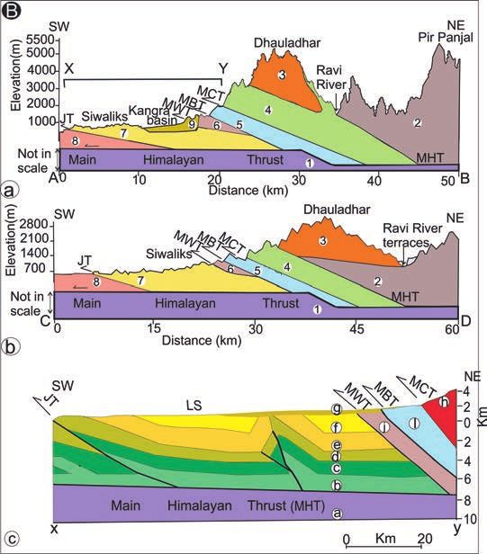
339

Srivastava, 1992; Srivastava et al., 2009), and are drained by feeder
streams originating on the southern flank of the D-Range (Fig. 3).
                                                                            Optically Stimulated Luminescence
On the southern margin of the K-Basin, the Upper Siwalik Boulder            (OSL) Chronology
Conglomerate formation dips NE 30º. In its northern extension, the
Boulder Conglomerate formation continues underlying the K-Basin                  Loess–paleosol bands occurring within the Kangra fan sediments
sediments with an intervening unconsolidated boulder bed, suggesting        were earlier dated using Infrared Stimulated Luminesence (IRSL)
an unconformity. This stratigraphic unconformity is observed at             method in the proximal and distal parts of the fan (Srivastava et al.,
several localities such as Gaj stream near Chambi, Churan stream            2009). We produced additional OSL dates from other parts of the
south of Skoh, Mataur, Jheol along the NH, Baner stream section             Kangra fan, and also incorporated earlier published OSL dates of the
near Nagrota Bagwan and at the base of the Siund ridge (Fig. 3).            strath terraces along the Baner River (Thakur et al., 2014). The OSL
Further in northernmost part of fans, the debris flow sediments             dating was carried at the Wadia Institute of Himalayan Geology, Dehra
unconformably overlie the Dharamsala Formation.                             Dun, following the standard protocol (Murray and Wintle, 2000).
     Based on the nature of clasts and matrix, we categorize three          Table 1 presents the IRSL and OSL dates of sediments of the Kangra
main types of the K-Basin fan sediments: a) Granite debris flow (Dfg):      Basin from its proximal and distal parts of the fan and strath terraces
unsorted, angular to subangular, pebble to very large size granite          south of Kangra along with recently-published 10Be dates (cf., Dey et
boulders in coarse grit-sand-silt granitic matrix with fresh felspars       al., 2016a, b).
laths. b) Mud flow debris (Dfd): angular to subangular unsorted clasts
of largely Dharamsala sandstone with a few phyllite, quartzite,             Proximal part of Kangra fan
volcanics and rarely granite, embedded in brown earthy colour silt
and mud matrix. At some places, the Dfd is overlain by the loess–               The sand sample (DSL 2), extracted from the Dfg unit in a trench
plaeosol. c) Boulder bed fluvial (Bbf): unconsolidated and partially        near the main Petrol pump of Dharamsala (32º12’:76º19’) (Fig. 5a),
stratified, with subrounded boulders to pebbles of sandstone, quartzite,    gives OSL age as 30.3 ± 5.2 ka (Table 1). The Dfg extends to the
phyllite and a few volcanics in sand matrix.                                south along the ridge top surface, and a second sample (DSL 3),
     About 2-4 m thick loess beds occur as interbeds within the debris      extracted ~5 km south of the Petrol pump (32º11’:76°17’), gives OSL
flow or form the top surface over the debris flow and fluvial sediments.    age of 40.5 ± 5.3 ka (Table 1) (Fig. 5b). In the proximal part of the
Orange- to- brown colour loess paleosol horizons were identified as         Kangra fan near mountain front, ~8 km east of Dharamsala at Patola
pedogenized loess through pedological analysis and dated at localities      Khanyara (32°12’:76°21’), a sand lens (PAT-1) gives OSL age of
Iku khad in the proximal part and Gagal in the distal part of the Kangra    12.5 ± 1.1 ka in the debris flow (Fig. 5c) (Table 1).
fan (Srivastava et al., 2009). Loess-paleosol beds are observed at              The Dfd lithological unit is best exposed on the eastern margin
several other localities; notably around Police Ground and Post Office      of Dharamsala ridge. It consists of subangular, unsorted, cobbles to
in the Dharamsala town, south of Yol Cantonment, Iku khad (stream),         pebbles size clasts in silt-mud matrix. The clasts are largely (~90%)
Gopalpur in the proximal part, along NH at Gagal airport and Dughiari       of sandstone, quartzite and a few phyllite and rarely granite. The Dfd
in the distal part of the Kangra fan (Fig. 3).                              top is characterized with 2-3 m thick orange yellow loess-paleosols
     Location of the K–Basin adjacent to southern mountain front of         as exposed near Police Ground and Post Office slope of Dharamsala
the D–Range (Figs. 1A, 2A) and its drainage catchment indicates             town. Further south towards the terminal part of the Dharamsala ridge,
that the sediments for debris flow fans are dominantly derived from         the Dfd merges with the distal planar lower surface near Gagal Airport,
this range. In the proximal part of debris flow fans, angular and faceted   where orange to brown-red loess paleosols are exposed. On the eastern
boulders and cobbles of dominantly granite in coarse sand matrix            margin of the Dhrarmsala ridge, the mud flow deposit (DSL1) gives
with feldspar laths and also clasts-supported boulders occur near the       OSL ages of 7.5 ± 0.5 ka (Table 1) near Lajwanti nursery, Shyamnagar
exits of Churan, Manjhi, Manooni, Iku, and Baner streams. Some              (32°12’:76°19’) and 7.6±0.5 ka (PG 1, Table 1) near the base of cliff
large outclasts granite boulders (size >10 m) occur as stand-alone          section close to cricket stadium (32°5’:76°20’). These two younger
erratics on debris flow surfaces. Large granite boulders, occurring as      Holocene ages may be due to reworking and redeposition of the older
clusters on the fan surface and in stream channels, are distributed         fan sediment.
from proximal to distal parts of the fans (Fig. 4A). The outsize granite        In the proximal part of the fan, northward continuation of the
boulders stand-alone over the Lower surface in the terminal part of         Siund ridge, the Iku khad section exposes 4 m thick loess-paleosol
the fan (Fig. 4B), and also within the gravel cover of Baner river          bed overlain and underlain by the granite boulder-bearing debris flow.
strath terrace at 800-600 m altitude. The outsize granite boulders are      The IRSL ages of the loess paleosol of the Iku Khad section are 78.6
distributed in the Kangra fan and also reached up to 10-15 km away          ± 17.7 ka (K26 M, Table 1) at the base and 44.2±6.2 ka (K24 M,
from the Range front in the distal part; size and distance travelled        Table 1) for the top (Srivastava et al., 2009). We dated the sand bed
imply that these were either transported through catastrophic floods        in debris flow overlying the loess–plaleosol at road section along Iku
or through past glacial abrasion as is indicated by their striated and      stream, which yields OSL age as 24.1 ± 3.1 ka (Table 1).
flat surfaces (Figs. 4C, 4D). Diamictite-type lithology having angular
and unsorted clasts in sandy matrix, besides snow white sand matrix         Distal part of Kangra fan
with undecomposed feldspar laths and grains, indicate their glacial
origin and transport from the D–Range to the K–Basin during                     The unconsolidated boulder bed exposed at Chambi bridge
deglaciation. These glacier-related features, occurrence of loess           extends eastward along the NH, at the road bend towards Gagal
paleosol beds within debris flows and physiographic setting of the          Airport, is overlain by debris flow and capped by 3 m thick orange-
basin suggest the debris flow fans similar to the paraglacial deposits      red loess paleosol. A sand band in unconsolidated boulder bed gives
(Ryder, 1971a, b; Church and Ryder, 1972).                                  OSL age as 91.0 ± 13.9 ka (KG 7, Table 1). The orange red loess-

Episodes Vol. 43, no. 1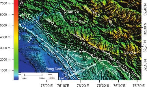
340

Figure 4. A). Outsize granite boulders (scale: a man standing on boulder) in the Manjhi river channel consisting debris flow deposit. B)
Out–size granite boulder is in the distal part, lower surface, 15 km south of the mountain front. C) Glacial striations on the granite boulder.
D) Granite boulder abraded with flat surface. Boulder is embedded in silt-clay matrix, D-Range-red loess paleosol.

paleosol bed extends along the highway close to entrance of Gagal          incises the Kangra fan sediments in northern part and the Siwalik
Airport. This unit is correlatable to the Gagal loess paleosol, reported   Range strata in southern part. This river incises 40-88m of the Siwalik
and dated by Srivastava et al. (2009). The unit gives IRSL ages as         bedrock, and deposits 5-20 m thick fluvial gravel cover with well-
30.8 ± 7.7 ka (K17 M, Table 1) for the bottom part and 19.9 ± 3.5 ka       developed gravel strath terraces having subrounded to rounded
(K13 M, Table 1) for the top part. At a locality, along the road cutting   boulders of Dhauladhar granite together with sandstone-siltstone,
between Tiara and Dughiari, 3 m thick orange-red loess paleosol unit       phyllite and quartzite. The strath (bedrock) terraces were mapped
gives OSL age as 40.7 ± 2.5 ka (DSL 6, Table 1). This locality a few       and dated using OSL technique along the Baner (Banganga) river
km to the south represents the extension of the loess paleosol exposed     (Fig. 6) (Thakur et al., 2014). Kangra T3, T2, Chatra T3, Jaladi T4,
along the highway close to Gagal Airport. Further north, the sand          Jalakhadi T2 and Haripur T2 terraces are located 65 m, 49 m, 75 m, 88
lens in granite boulder-bearing debris flow overlying the loess paleosol   m, 70 m and 40 m above the river grade, respectively. The strath
is dated as 15.1 ± 1.6 ka (DSL 5, Table 1). West of Nagrota Bagwan         terrace surfaces are overlain with 5-10 m thick gravel cover in sand/
along the Baner River bridge, ~20 km east of Gagal, the lower surface      silt matrix. The sand layer in gravels over strath surfaces were OSL-
constitutes the Upper Siwalik Boulder Conglomerate, overlain by            dated to determine their abandoned ages and time of incision. The
unconsolidated boulder bed. The boulder bed consists of clasts of          strath terrace surfaces give OSL ages as: a) 18.3 ± 2.6 ka (Kangra T2)
granite with some quartzite and sandstone clasts in sand and grit          and 33.6 ± 3.7 ka (Kangra T3), b) 30.7 ± 1.2 ka (Chatra T3), c) 76.2 ±
matrix. Here, the sand lens in the unconsolidated boulder bed gives        8.6 ka (Jaladi T4), d) 22.8 ± 2.7 ka (Jalakhadi T2), and e) 13.0 ± 1.5 ka
OSL age as 18.3 ± 0.5 ka (NG 1, Table 1).                                  (Haripur T2) (Table 1). Based on vertical offset (distance between
                                                                           river grade and strath surface), OSl date and 30° dip of JT, uplift and
Strath terraces in Siwalik bed rock                                        shortening rates are estimated (Fig. 2B). The bed-rock incision (uplift)
                                                                           rates estimated for the T3 and T2 terraces are 2.0–2.4 mm/yr and 2.8–
     The K–Basin is flanked to the south by the Siwalik Range, where       3.1 mm/yr over a period 33–30 ka and 22–18 ka, respectively. The
strath terraces are developed along the Baner River. It flows southwest    bed-rock incision of the strath terraces is considered as representing
from the southern slope of the Dhauladhar Range and drains into the        bed-rock uplift. The strath terraces, lying over the hanging wall of
Pong dam reservoir erected across the Beas river (Fig. 1A). The river      the Jawalmukhi Thrust (JT), were uplifted as a result of slip–induced

                                                                                                                                       March 2020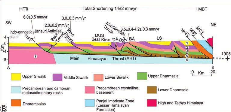
341

Table 1. Compiled dates of Kangra basin sediments and Baner (Banganga) River strath terraces.
                                                                      Kangra Basin (Present study)

Sample          Location       Sample                                                              Equivalent Dose (De) Gy                                  Age (ka)
No.                            depth       U (ppm)           Th (ppm)       Potassium            Weighted                           Dose rate     Weighted
                                (m)                                           K (%)              Mean De          Mean De           (Gy/ka)        Mean            Mean
DSL-1        32º12’/76º19’        2        3.1±0.03          18.5±0.19      1.69±0.02           26.65±1.67       26.90±1.72         3.57±0.05       7.5±0.5       7.5±0.5
DSL-2        32º12’/76º19’        2        4.2±0.04          25.1±0.25      3.85±0.04           188.3±32.24     204.86±30.07        6.21±0.08       30.3±5.2      33.0±4.9
DSL-3        32º11’/76º17’        2        4.8±0.05          35.4±0.35      3.49±0.03          270.11±34.90     269.69±33.59        6.67±0.09       40.5±5.3      40.5±5.1
DSL-5        32º10’/76º15’        2        4.6±0.05          32.7±0.33      3.78±0.04          101.33±10.63      103.41±8.90        6.70±0.09       15.1±1.6      15.4±1.3
DSL-6        32º08’/76º14’        2        2.2±0.02          21.3±0.21      2.19±0.02             163±9.8        163.74±9.06        4.01±0.05       40.7±2.5      40.9±2.3
PAT-1        32º12’/76º21’        3        3.65±0.04          20±0.2        2.24±0.02            51.87±4.7       55.55±5.60         4.16±0.06       12.5±1.1      13.3±1.4
NG-1      32º05’/76º 22’          18      4.86±0.05           19.7±0.2      2.41±0.02           78.23±1.95       78.57±1.98         4.29±0.07       18.3±0.5      18.3±0.6
PG-1         32°5’/76°20’         50       2.2±0.02           14±0.14       1.76±0.02           23.88±1.68       24.12±1.76         3.13±0.04       7.6±0.5       7.7±0.6
IK-4      32º09’/76º 24’          4          1±0.01           20.1±0.2       4.0±0.04          133.49±17.29      154.31±36.4        5.54±0.07       24.1±3.1      27.9±6.6
KG-7         32º10’/76º15’        6        1.72±0.02         16.6±0.17      2.64±0.03           376.21±57.2     428.91±53.72        4.14±0.05     91.0±13.9 103.7±13.1

                                                                          Srivastava et al. (2009)
                                                       238                   232                     40
Sample no.         Location            Depth                 U (ppm)               Th (ppm)           K (%)          Dose rate          (Gy/ka) ED         (Gy) Age (ka)
K-13M              Gagal-II,            3m              4.9±2.20             16.50±4.00                   2.3        6.00±1.00          119.8±8.1             19.9±3.5
K-17M              Gagal-II,            5.5 m            4.7±2.2              15.8±3.8                    2.9         5.7±1.0           177.5±32.1            30.8±7.7
K-24M                Iku,               16 m             8.9±3.0              29.6±5.4                    2.4         9.0±1.4           398.5±36.9            44.2±6.2
K-26M                Iku,               18 m            12.3±3.5              41.0±6.4                    2.2         11.5±1.7        901.66±151.2          78.6±17.7

                                                                            Dey et al. (2016a)

Sample no.             Location                 Exposure age (St age) (depth             Exposure age (Lm age) (depth            Exposure age (Lm age) (inheritance-
                                                   profile)(ka) (2σ error)                 profile fit) (ka) (1σ error)         corrected surface sample) (ka)(1σ error)
T1-P1 (sc. B)       32.068/76.399                        57.3+4.5                                    53.4+3.2                                   48.7+3.1
T1-P2               32.059/76.426                        50.1+4.1                                    43.0+2.7                                   39.2+2.8
T2-P2               32.184/76.297                        19.5+2.2                                    18.6+1.2                                   19.8+1.3
T2-P1               32.106/76.262                            16.3+1                                  15.3+0.9                                   16.1+1.0

                                                  Banganga (Baner) river strath terraces (Thakur et al., 2014)

                               Sample                                                              Equivalent Dose (De) Gy                                  Age (ka)
Sample          Location       depth       U (ppm)           Th (ppm)       Potassium            Weighted                           Dose rate     Weighted
No.                             (m)                                           K (%)              Mean De          Mean De           (Gy/ka)        Mean            Mean
DSL-8     32°052/76°162           3        3.95±0.04         22.85±0.23      2.5±0.03           89.46±12.59      93.92±20.14        4.9±0.06        18.3±2.6      19.2±4.2
JL-1         32°03'/76º13'        5        3.23±0.03          14±0.14         2±0.02           279.69±31.52      294.69±35.7        3.67±0.04       76.2±8.6      80.3±9.8
RN-1      32°012/ 76°132          4       1.25±0.01           15±0.15       2.61±0.03           86.37±10.34      87.99±9.41         3.78±0.26       22.8±2.7      23.3±3.0
RN-2      32°012/76°142           3        2.01±0.01          24±0.24       4.12±0.04           188.21±6.80      188.85±6.70        6.13±0.07       30.7±1.2      30.8±1.1

upthrust motion. The JT is characterized by a fault-propagated frontal                        mid-latitude westerlies during the winters. In the upper Beas valley
anticline (eroded) and a complementary broad synform of the K–                                south of Rohtang pass, an area close to the D-Range and 80 km east
Basin, mapped as Lambagaon syncline (Karunakaran and Rao, 1979;                               of Dharamsala, the morains are reported from the Solang and Palchan
Powers et al., 1998). The tectonic setting of the K-Basin is analogous                        valleys at the lowest altitude of 2500 m (Owen et al., 1996, 1997). In
to that of the piggy–back basin, formed and were filled while being                           the Ravi river catchment of the Chamba area, on northern flank of
carried on the moving thrust sheet (Ori and Friend, 1984).                                    the D–Range, the glaciation features are reported at altitude as low as
                                                                                              2600 m (Joshi and Tandon, 1987; Joshi, 2014). In the higher altitude
                                                                                              of eastern segment of the D-Range glaciers, glacial lakes and glacial-
Deglaciation induced erosion                                                                  carved physiographic features are observed in the Google images. In
    The southern flank of eastern D–Range and adjoining mountain                              the Survey of India topographic maps on 1:50, 000 scale, there are
spurs were the provenance for the K–Basin. In northwest Himalaya,                             12 falls (water) indicated with 40-60 m height scarps at altitude ranging
the Pir Panjal and Dhauladhar Ranges, the Beas valley, the Lahaul                             3500 m to 3000 m. At Bhagsu Nath near Mcleodganj, there is a
and Garhwal regions are affected by the same climate system. These                            moraine ridge of ~500 m long and ~50 m high, consisting of large,
regions receive South Asian summer monsoon during summer and                                  angular and unsorted granite boulders in sand-grit matrix, granite

Episodes Vol. 43, no. 1
342
ka ages from the unit Dfg at the proximal
part of the fan along Dharamsala ridge.
These OSL ages are nearly analogous to
the OSL dates 43-36 ka obtained for Batal
glacial stage-I reported in the
neighbouring Lahaul area (Owen et al.,
1997). Srivastava et al. (2009) advocated
glacial advances in the area at 78-44 ka
and 30-20 ka during the last glacial cycle.
In more recent study, the Kangra fan
sediments are dated using cosmogenic
nuclide (10Be) dating method. The two
sets of ages obtained are 53.4 ± 3.2 ka
and 43.0 ± 2.2 ka for the older fan and
18.6 ± 1.2 ka and 15.3 ± 0.9 ka for the
younger fan (Dey et al., 2016a). The OSL
ages and climatic signatures in the
Kangra fan sediments suggest more
extensive last glacial cycle as compared
to the LGM affecting the Dhauladhar
Range. This period coincides with the
period of insolation maximum and
strengthening of monsoon and advance
of glaciers (Owen et al., 2002).
Discussions and
conclusions
The K-Basin fan sediments were
deposited in a growing synformal
depression of the Lambagaon syncline
(Figs. 2A, B), similar to the dun, created
between the MBT and the JT. The Upper
Siwalik Boulder Conglomerate,
Figure 5. Localities of OSL dated samples. A) A trench adjacent petrol pump near Kotwali bazaar
constituting the base of the K-Basin
Dharamsala (32º12’:76º19’), sample: (DSL 2). B) Near Kunal Patri temple, Dharamsala ridge
sediments, represents continuation of the
(32º11’:76º17’), sample: (DSL3). C) Patola, Ghanyara, ~8 km east of Dharamsala (32º10’:76º15’),
Boulder Conglomerate that forms upper
sample: (DSL 5).
part of the sequence exposed in Kangra-
Ranital section. The magnetostratigraphic
erratics and a waterfall along the Churan stream. Similar features of dating of this section gives 5.9 Ma age at the base (Sangode et al.,
the past glaciation also occur near the exits of Manjhi and Manuni 2003), whereas 0.2 Ma age is assigned to the top part of the Boulder
streams (Fig. 3), and indicate that the glacier margin lobes extended Conglomerate in Jammu area (Rao et al., 1988). The Boulder
down to lower altitude. Conglomerate is consolidated with sand-grit matrix and composed
The eastern D-Range is characterized with high altitude of 5000– of pebbles, cobbles and boulders of predominantly quartzite, sandstone
4000 m and steep gradient, which receives focused southwest and siltstone with some volcanics and phyllite of the Lesser Himalayan
monsoon precipitation up to 2500-3000 mm/yr (Sharma and affinity with a few granitic gneiss and leucogranite of the Higher
Bandooni, 2007). The glaciers are highly efficient erosional agents, Himalaya Crystalline affinity. The clast composition indicates their
more effective than fluvial erosion, and produce large volumes of provenance largely from the Lesser Himalaya and to some extent
debris sediments within their restricted domains (Hallet et al., 1996). from the Higher Himalaya. Lack of Dhauladhar granite clasts in the
During the glaciation period, the glacier cover and their downward Upper Siwalik Boulder Conglomerate and their predominance in the
advances on the steeper gradients produce large volume of debris fans of K-Basin imply that the D-Range granite was not the prime
through glacial denudational processes. Glacially-eroded sediment source for the Boulder Conglomerate, whereas the same granite body
flux was later transported during monsoon precipitation or by contributed significantly to the K-Basin. This may imply that
catastrophic floods and deposited in the K-Basin. The occurrence of exhumation of the Dhauladhar granite occurred post-Upper Siwalik
loess deposits in the fan sediments indicates cold–arid climate. In the Boulder Conglomerate to become the source for the K-Basin. This
mountainous areas, the loesses are deposited on the margins of may further suggest that southwesterly-flowing rivers/streams,
glaciers. We obtained 40 ka OSL age from near the top surface of the originating from the southern flank of D-Range, were developed
loess-paleosol in the distal part of the fan near Dughiari, and 30-40 during the renewed uplift of the D-Range post-dating the Upper
March 2020343
Figure 6. Geological map between Kangra and Guler, south of the K-Basin. Stippled areas show strath terraces along Baner (Banganga)
river. The strath terraces are Kangra and Chatra on upper left inset, and Jaladi and Jalakhari on lower left inset. Dot-locality, Star-locality
with elevation, Cross-OSL sample locality with sample number. Inset shows different strath terraces with thickness between river grade and
strath surface and gravel cover, sample number and OSL age. Modified after Thakur et al. (2014).
Siwalik Boulder Conglomerate. This inference is corroborated with (Fig. 1B) (Thakur et al., 2000; Kumar et al., 2009). It is envisaged
the presence of an unconformity between the consolidated Upper that the D–Range grew as a whole length in a steady-state in initial
Siwalik Boulder Conglomerate and the overlying unconsolidated stage that was in equilibrium with tectonic influx and erosional outflux
boulder bed and fan sediments of the K-Basin. The timing of the up to a certain critical level sharing the same altitude. The formation
hiatus may be constrained between the age of 0.2 Ma of top part of of ramp was responsible for the higher altitude of the eastern D–
the Boulder Conglomerate and the oldest OSL-dated (91 ka) Range (Thakur, 1998). The erosion accelerated several times due to
unconsolidated fluvial boulder bed. orographic enhancement of precipitation in the eastern parts with
The structural and stratigraphic framework is continuous and same higher altitude during the last glacial cycle and the LGM glaciation.
along the entire NW–SE trending D–Range. The K-Basin is developed The occurrence of paleosols in the Kangra fan sediments, indicative
south of the higher altitude, 5000–3000 m, segment of the D–Range. of pedogenization, suggest warm–wet climate (Srivastava et al., 2009)
The basin has not extended to the south of the lower altitude western with the onset of deglaciation. The deglaciation–induced erosion of
part of the Range. There is no structural feature observed to account the D-Range generated debris flow deposits into the K-Basin. Climate-
for relative higher altitude of the eastern part of the D–Range. The induced erosion affects subsurface internal deformation leading to
higher altitude segment receives focused and highest precipitation. reorganization of fault system (Dahlen and Suppe, 1988; Whipple
The instrumental recorded microseismicity in the region indicates and Meade, 2006; Berger et al., 2008). Climate-induced enhanced
dense clustering of events in the eastern part of the D–Range and the erosion affected the internal deformation of the D-Range leading to
hinterland region, whereas microseismicity is much less pronounced contraction of the wedge and reactivation of the JT–MHT during
in the western part (Kumar et al., 2009). The rupture zone of 1905 Late Quaternary–Holocene. This appears to be currently reflected in
Kangra earthquake magnitude Mw 7.8 (Wallace et al., 2005) also lies microseismicity clusters and presence of the 1905 Kangra earthquake
in the eastern part. The distribution of microseismicity pattern, abrupt seismogenic zone at mid-crustal level of eastern part of the D–Range.
rise of the eastern D–Range with steep gradient to the south and The post Siwalik K-Basin, filled by eroded flux from the southern
tectonic setting indicate a ramp at mid- crustal level under the Range flank of the eastern D-Range, is developed over the hanging wall of
Episodes Vol. 43, no. 1344
the Jawalamukhi Thrust (JT). The K-Basin was formed as a piggy– Joshi, D.D., and Tandon, S.K., 1987, Quaternary valley-fill deposits
back basin during Late Quaternary, similar to the basin developed on of the Ravi drainage basin in Chamba, Western Himalaya:
the back of an active thrust (Ori and Friend, 1984). The occurrence definition, lithostratigraphy and depositional framework: Journal
of strath terraces on the hanging wall of the JT with their formation of the Geological Society of India, v. 29, pp. 540-553.
Joshi, M., 2014, Climate-tectonic interaction in the morphogenic
ages 76 ka to 18 ka suggest that the JT was active during Late
evolution of Ravi river basin in Chamba region, western Himachal
Quaternary. The JT was developed as a foreland propagating fold–
Pradesh, NW Himalaya. Unpublished D. Phil. Thesis, Garhwal
thrust system south of the MBT. The strath terraces indicate uplift University, Srinagar.
due to slip over the JT. The OSL ages of the strath surfaces point to Karunakaran, C., and Rao, R., 1979, Status of hydrocarbon in the
reactivation ages of the JT during Late Quaternary. The K–basin Himalayan region: Contributions to stratigraphy and structure:
depositional ages, 78–15 ka (Late Quaternary) correspond to the strath Geological Survey of India, Miscellaneous Publication, v. 41,
surface ages of the terraces above the JT. This implies that reactivation pp. 1-66.
of the JT led to the formation of K-Basin, which is filled by sediments Kumar, N., Sharma, J., Arora, B.R., and Mukhopadhyay, S., 2009,
derived from the D-Range due to the glaciation-deglaciation processes. Seismotectonic model of the Kangra-Chamba sector of northwest
It suggests that there is a temporal–spatial relationship between Himalaya: constraints from joint hypocenter determination and
reactivation of the JT and formation of the K–basin, that was coupled focal mechanism: Bulletin of the Seismological Society of
America, v. 99, pp. 1-15.
with climate induced erosion of the D–Range for its filling.
Murray, A.S., and Wintle, A.G., 2000, Luminescence dating of quartz
using an improved single aliquot regenerative-dose protocol:
Acknowledgements Radiation measurements, v. 32(1), pp. 57-73.
Najman, Y., Bickle, M., Garzanti, E., Pringle, M., Barfod, D.,
We thank Director, WIHG for the logistic support. The Department Brozovic, N., Burbank, D., and Ando, S., 2009, Reconstructing
of Science and Technology, Government of India, provided the the exhumation history of the Lesser Himalaya, NW India, from
financial support to the project. MJ acknowledge Director, a multitechnique provenance study of the foreland basin Siwalik
GBPNIHESD for his support. Group: Tectonics, v 28, Tc5018.
Ori, G.G., and Friend, F.P., 1984, Sedimentary basins formed and
carried piggy back on active thrust sheets: Geology, v. 12, pp.
References 475–478.
Owen, L.A., Benn, D.I., Derbyshire, E., Evans, D.J.A., Mitchell, W.A.
Beaumont, C., Jamieson, R.A., Nguyen, M.H., and Lee, B., 2001, and Richardson, S., 1996, The Quaternary glacial history of the
Himalayan tectonics explained by extrusion of a low-viscosity Lahul Himalaya, Northern India: Journal of Quaternary Science,
crustal channel coupled to focused surface denudation: Nature, v. 11 (1), pp. 25–42.
v. 414, pp. 738-742. Owen, L.A., Bailey, R.M., and Rhodes, E.J., 1997, Style and timing
Berger, A.L., Gulick, S.P.S., Sapotila, J.A., Upton, P., and other of glaciation in the Lahul Himalaya, northern India: a framework
members., 2008, Quaternary tectonic response to intensified for reconstructing Late Quaternary palaeoclimatic change in the
glacial erosion in an orogenic wedge: Nature Geoscience, v. 1, western Himalayas: Journal of Quaternary Science, v. 12, pp. 83-
pp. 793-799. 109.
Church, M.A., and Ryder, J.M., 1972, Paraglacial sedimentation: a Owen, L.A., Finkel, R.C., and Caffee, M.W., 2002, A note on the
consideration of fluvial processes conditioned by glaciations: extent of glaciation in the Himalaya during the global Last Glacial
Geological Society of America Bulletin, v. 83, pp. 3059-3071. Maximum: Quaternary Science Review, v. 21, pp. 147-158.
Dahlen, F.A., and Suppe, J., 1988, Mechanics, growth, and erosion Powers, P.M., Lillie, R.J., and Yeats, R.S., 1998, Structure and
of mountain belts. Processes in Continental Lithospheric shortening of Kangra and Dehradun re-entrants, sub-Himalaya,
Deformation: Geological Society of America, v. 218, pp.161-178. India: Geological Society of American Bulletin, v. 110, pp. 1010-
DeCelles, P.G., Robinson, D.M., Quade, J., Ojha, T.P., Garzione, C.N., 1027.
Copeland, P., and Upreti, B.N., 2001, Stratigraphy, structure, and Ranga Rao, A., Agarwal, R.P., Sharma, U.N., Bhalla, M.S., and Nanda,
tectonic evolution of the Himalayan fold-thrust belt in western A.C., 1988, Magnetic polarity stratigraphy and vertebrate
Nepal: Tectonics, v. 20 (4), pp. 487-509. paleontology of upper Siwalik of the Jammu Hills: Journal of
Deeken, A., Thiede, R.C., Sobel, E.R., Hourigan, J.K., and Strecker, Geological Society of India, v. 32, pp. 109-128.
M.R., 2011, Exhumational variability within the Himalaya of Robinson, D.M., DeCelles, P.G., and Copeland, P., 2006, Tectonic
northwest India: Earth and Planetary Science Letters, v. 305, pp. evolution of the Himalayan thrust belt in western Nepal:
103-114. Geological Society of American Bulletin, v. 118, pp. 865-885.
Dey, S., Thiede, R.C., Schildgen, T.F., Wittmann, H., Bookhagen, Ryder, J.M., 1971a, Some aspects of the morphology of paraglacial
B., Scherler, D., Jain, V., and Strecker, M.R., 2016a, Climate- alluvial fans in south-Central British Columbia: Canadian Journal
driven sediment aggradation and incision since the late Pleistocene of Earth Sciences, v. 8, pp. 1252-1264.
in the NW Himalaya, India: Earth and Planetary Science Letters, Ryder, J.M., 1971b, The stratigraphy and morphology of paraglacial
v. 449, pp. 321-331. alluvial fans in south-central British Columbia: Canadian Journal
Dey, S., Thiede, R.C., Schildgen, T.F., Wittmann, H., Bookhagen, of Earth Sciences v. 8, pp. 279-298.
B., Scherler, D., and Strecker, M. R., 2016b, Holocene internal Sah, M.P., and Srivastava, R.A.K., 1992, Morphology and facies of
shortening within the northwest Sub-Himalaya: Out-of-sequence the alluvial fan sedimentation in the Kangra valley, Himachal
faulting of the Jwalamukhi Thrust, India: Tectonics, v. 35 (11), Himalaya: Sedimentary Geology, v. 76, pp. 23-42.
pp. 2677-2697. Sangode, S.J., Kumar, R., and Ghosh, S.K., 2003, Magnetic polarity
Hallet, B., Hunter, L., and Bogen, J., 1996, Rates of erosion and stratigraphy of the Late Miocene Siwalik Group sediments from
sediment evacuation by glaciers: A review of field data and their Kangra Re-entrant, H.P. India: Himalayan Geology, v. 24 (1), pp.
implications: Global and Planetary Change, v. 12, pp. 312-235. 47-61.
March 2020345
Sharma, K.K., and Bandooni, S.K., 2007, Data base for mitigatio of the great 1905 Kangra earthquake meizoseismal region in
and management of earthquake and landslides (Geohazard) on Kangra–Chamba, NW Himalaya: Tectonophysics, v. 326(3), 289-
GIS platform using space technology for Kangra, Mandi, 298.
Hamirpur and Una districts of Himachal Pradesh. Project Report, Thiede, R.C., Bookhagen, B., Arrowsmith, J.R., Sobel, E.R., and
DST, New Delhi. Strecker, M.R., 2004, Climatic control on rapid exhumation along
Schelling, D., and Arita K., 1991, Thrusts tectonics, crustal shortening the southern Himalayan Front: Earth and Planetary Science Letter,
and the structure of the far Eastern Nepal Himalaya, Tectonics, v. v. 222, pp. 791-806.
10, pp. 851–862. Wallace, K., Bilham, R., Blume, F., Gaur, V.K., and Gahalaut, V.,
Srivastava, P., Rajak, M.K., and Singh, L.P., 2009, Late Quaternary 2005, Surface deformation in the region of the 1905 Kangra
alluvial fans and palaeosole of the K-Basin, NW Himalaya: Mw=7.8 earthquake in the period 1846-2001: Geophysical
tectonic and palaeoclimatic implication: Catena, v. 76, pp. 135- Research Letters, v. 32, L15307.
154. Whipple, K.X., and Meade, B.J., 2006, Orogen response to changes
Thakur, V.C., 1998, Structure of the Chamba nappe and position of in climatic and tectonic forcing: Earth and Planetary Science
the Main Central Thrust in Kashmir Himalaya: Journal of Asian Letter, v. 243, pp. 218-228.
Earth Science, v. 16, pp. 269-282. Wobus, C.W., Hodges, K.V., and Whipple, K.X., 2003, Has focused
Thakur, V.C., Joshi, M., Sahoo, D., Suresh, N., Jayangondapermal, denudation sustained active thrusting at the Himalayan
R., and Singh, A., 2014, Partitioning of convergence in Northwest topographic front?:Geology, v. 31, pp. 861-864.
Sub-Himalaya: estimation of late Quaternary uplift and Yin, A., 2006, Cenozoic tectonic evolution of the Himalayan orogen
convergence rates across the Kangra reentrant, North India: as constrained by along-strike variation of structural geometry,
International Journal of Earth Sciences, v. 103(4), pp. 1037–1056. exhumation history, and foreland sedimentation: Earth Science
Thakur, V.C., Sriram, V., and Mundepi, A.K., 2000, Seismotectonics Review, v. 76, pp. 1-131.
Dr. Vikram C. Thakur is M.Sc. (Panjab) Dr. Suresh Narayanapanicker has
and Ph.D. DIC (Imperial College, London). graduated from Kerala University and
He is former Director, Wadia Institute of obtained his post graduation from Cochin
Himalayan Geology, Dehradun and CSIR University of Science and Technology,
Emeritus Scientist. Dr. Thakur is a Fellow India.He carried out the Ph.D work from
of Indian Academy of Sciences, recipient 1989-1993 at Wadia Institute of Himalayan
of National Mineral Award and Padama Geology (WIHG), Dehradun, and obtained
Shree awardee. He has contributed on the the degree from HNB Garhwal University,
regional framework and tectonics of suture India. His PhD work is Sediment Dispersal
zone of Ladakh and Arunachal, structure in the Bay of Bengal with special emphasis
of Chamba nappe sequence, and active on mineralogy and geochemistry. His post-
tectonics of NW Sub Himalaya. Authored doctoral work includes evolution of
a book on “Geology of Western Himalaya”, Quaternary alluvial fans and fluvial deposits
Pergamon Press, and co – authored the and active tectonic studies.
recent book “ Active tectonics of Kumaun He joined the sedimentology Group of
and Garhwal Himalaya”, Springer. WIHG in 2005 as Scientist.Hiswork includes
sedimentology and luminescence dating of
alluvial fans and fluvial deposits in the
Himalaya, particularly from the ‘Duns’ in
the Sub-Himalaya. His other expertise
Dr. Mayank Joshi obtained Post
includes clay mineral analysis, active
Graduation from Kumaun University and
tectonic studies, paleoseismicityand trench
Ph.D. from Wadia Institute of Himalayan
excavation survey for earthquake hazard
Geology, India. His Ph.D work was focused
assessment. He is an expert in luminescence
on the Quaternary landform evolution in
dating technique and clay mineral studies
Chamba nappe and active tectonics of the
and looking after these labs at WIHG.
region. His work includes tectonic
Geomorphology, Quaternary landform
evolution in Himalayan region, climate
change and societal disturbances with
special on people perceptions. His other
expertise includes landslide and subsidence
studies, Hydro-geology, achaeo-seismology
for earthquake hazards assessment.
Episodes Vol. 43, no. 1You can also read