Towards a Distortion Free National Spatial Data Infrastructure in Switzerland: Approach, Developed Tools and Internet Services for the Change of ...
←
→
Page content transcription
If your browser does not render page correctly, please read the page content below
Towards a Distortion Free National Spatial Data Infrastructure in
      Switzerland: Approach, Developed Tools and Internet Services for
                    the Change of the Reference Frame

            Matthias Kistler, Urs Marti, Jérôme Ray, Christian Baumann and
           Adrian Wiget (Federal Office of Topography swisstopo - Switzerland)

Key words: Geoinformation, GSDI, Internet Transformation services, Reference frames,
Rectification, Reference systems

SUMMARY

Switzerland is currently working on the transformation of the spatial data infrastructure into
the new, very accurate and distortion free reference frame LV95 (with relation to the
European Reference System ETRS89). This concerns among others also the cadastre datasets.
According to the law for geo-information all the reference datasets have to be transformed by
2016 and the other base datasets until 2020. In order that the transformation could be done as
easily and efficiently as possible by the different stakeholders, the national mapping agency of
Switzerland swisstopo developed a multitude of software packages, program libraries and geo
services (e.g. for transformations). The following publication gives an overview over the
"Swiss approach" for the so-called reference frame change and the provided software tools for
this purpose.

SUMMARY IN GERMAN / ZUSAMMENFASSUNG

Die Schweiz ist zurzeit daran, die Nationale Geodateninfrastruktur NGDI in den neuen,
hochgenauen und verzerrungsfreien Bezugsrahmen LV95 - mit Bezug zum europäischen
Bezugssystem ETRS89 - zu überführen. Davon betroffen sind unter anderem auch die
Kataster-Datensätze. Bis 2016 sollten gemäss dem Geoinformationsgesetz alle Referenz-
datensätze in LV95 georeferenziert sein und bis spätestens 2020 auch alle übrigen Geobasis-
datensätze. Damit diese Überführung möglichst einfach und effizient durch die verschiedenen
Akteure vollzogen werden kann, hat das Bundesamt für Landestopografie swisstopo eine
Vielzahl von Software, Programmbibliotheken und Geodiensten (z.B. für Transformationen)
entwickelt. Die nachfolgende Publikation gibt einen Überblick über das gewählte Vorgehen
für den sogenannten Bezugsrahmenwechsel in der Schweiz sowie über die dafür bereit-
gestellten Software-Werkzeuge.

Matthias Kistler, Urs Marti, Jérôme Ray, Christian Baumann and Adrian Wiget (Switzerland)   1/12
Towards a Distortion Free National Spatial Data Infrastructure in Switzerland:
Approach, Developed Tools and Internet Services for the Change of the Reference Frame

FIG Working week 2015
From the Wisdom of the Ages to the Challenges of the Modern World
Sofia, Bulgaria, 17-21 May 2015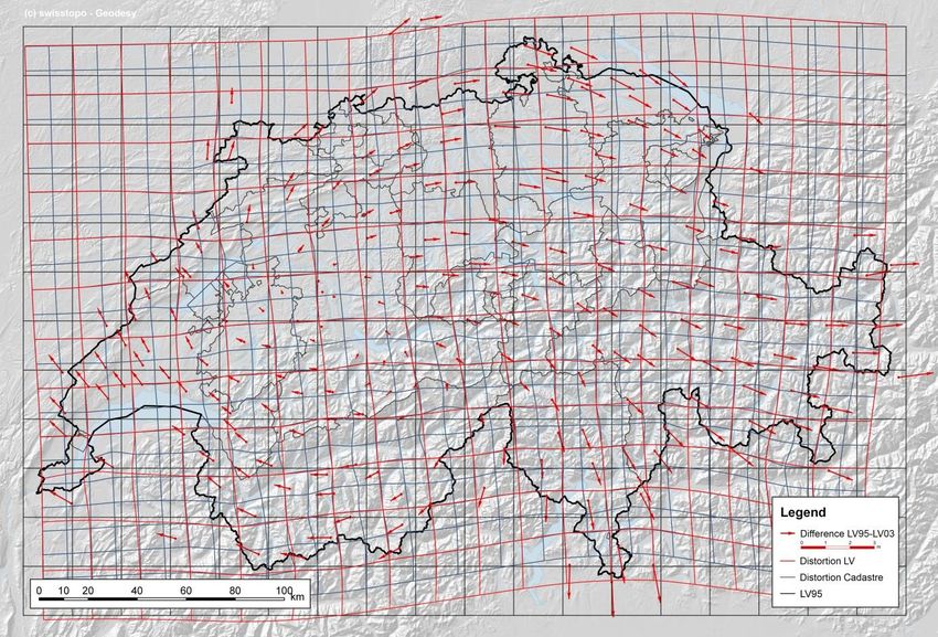
Towards a Distortion Free National Spatial Data Infrastructure in
      Switzerland: Approach, Developed Tools and Internet Services for
                    the Change of the Reference Frame

            Matthias Kistler, Urs Marti, Jérôme Ray, Christian Baumann and
           Adrian Wiget (Federal Office of Topography swisstopo - Switzerland)

1. STARTING POSITION AND APPROACH CHOSEN FOR THE REFERENCE
   FRAME CHANGE IN SWITZERLAND

In the nineties, the national mapping agency of Switzerland, swisstopo, established a new,
distortion free reference frame LV95, which is directly related to the European ETRF93.
Following this task, various transformation methods according the accuracy and properties of
the datasets, e.g. FINELTRA (affine transformation by finite elements), have been developed
in collaboration with the Swiss Federal Institute of Technology to be able to transform the
data of the National Spatial Data Infrastructure SDI from the historical reference frame LV03
to the new LV95 in high accuracy. The federal law for geo information stipulates now that all
the reference datasets have to be transformed until 2016 and for the other base data sets until
2020.

Matthias Kistler, Urs Marti, Jérôme Ray, Christian Baumann and Adrian Wiget (Switzerland)   2/12
Towards a Distortion Free National Spatial Data Infrastructure in Switzerland:
Approach, Developed Tools and Internet Services for the Change of the Reference Frame

FIG Working week 2015
From the Wisdom of the Ages to the Challenges of the Modern World
Sofia, Bulgaria, 17-21 May 2015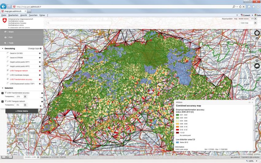
Figure 1: Distortion of the old reference frame LV03 in red (national survey LV) and blue
(cantonal / state level - cadastral survey) and new reference frame LV95 in black

Matthias Kistler, Urs Marti, Jérôme Ray, Christian Baumann and Adrian Wiget (Switzerland)   3/12
Towards a Distortion Free National Spatial Data Infrastructure in Switzerland:
Approach, Developed Tools and Internet Services for the Change of the Reference Frame

FIG Working week 2015
From the Wisdom of the Ages to the Challenges of the Modern World
Sofia, Bulgaria, 17-21 May 2015
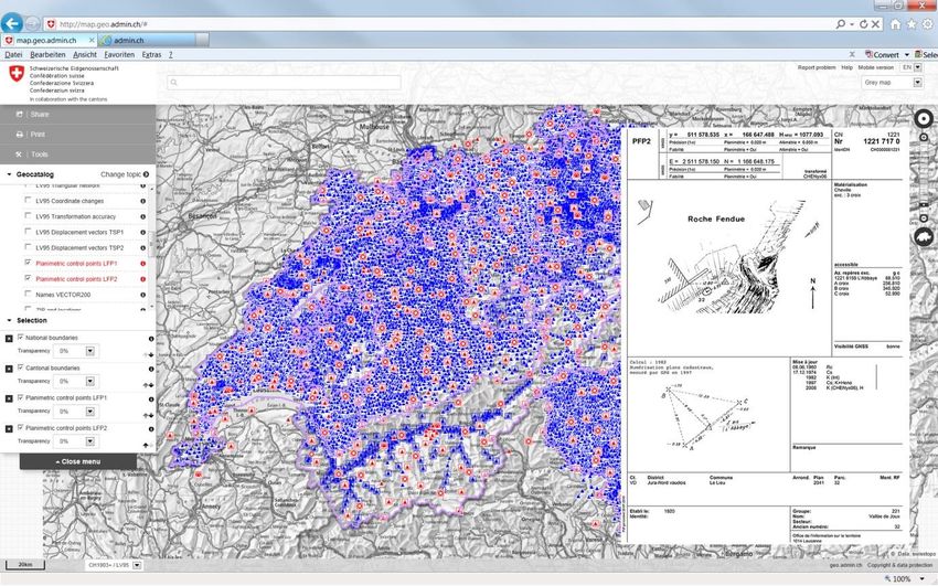
Figure 2: Different transformation and interpolation methods according to data accuracy and
data properties are available to perform the reference frame change as adequately as possible.
Furthermore associated software tools, internet services and program libraries are listed

Matthias Kistler, Urs Marti, Jérôme Ray, Christian Baumann and Adrian Wiget (Switzerland)   4/12
Towards a Distortion Free National Spatial Data Infrastructure in Switzerland:
Approach, Developed Tools and Internet Services for the Change of the Reference Frame

FIG Working week 2015
From the Wisdom of the Ages to the Challenges of the Modern World
Sofia, Bulgaria, 17-21 May 2015
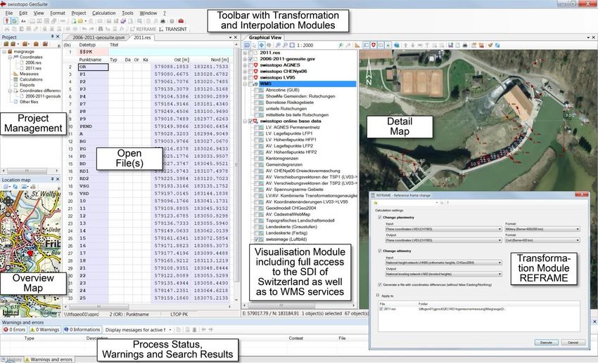
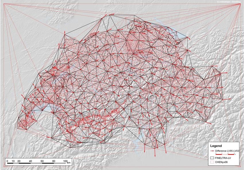
Figure 3: Swiss national triangular network to perform a affine transformation by finite
elements (FINELTRA-Algorithm). In black the triangles from the national survey, in red the
ones from cantonal / state level. FINELTRA is the standard method e.g. for cadastral datasets

2. DEVELOPED SOFTWARE TOOLS, LIBRARIES AND PLUGINS

So swisstopo was requested to develop a variety of software tools, libraries and services for
the reference frame change to support the different stakeholders best possible. In a first step,
the client solution GeoSuite with the modules REFRAME and TRANSINT have been
developed. This software is not only able to transform or interpolate geo datasets into various
formats (e.g. GIS or CAD quasi standard formats), it also provides direct access to all data
sets in the SDI of Switzerland over an integrated application programming interface API as
well as to any Web Map Service WMS available.

Matthias Kistler, Urs Marti, Jérôme Ray, Christian Baumann and Adrian Wiget (Switzerland)   5/12
Towards a Distortion Free National Spatial Data Infrastructure in Switzerland:
Approach, Developed Tools and Internet Services for the Change of the Reference Frame

FIG Working week 2015
From the Wisdom of the Ages to the Challenges of the Modern World
Sofia, Bulgaria, 17-21 May 2015
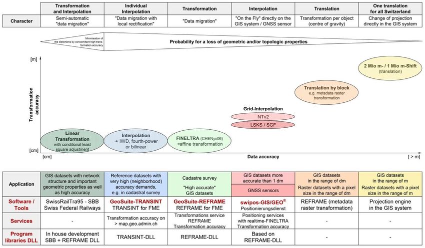
Figure 4: Graphic user interface GUI of the software GeoSuite with the different modules:
REFRAME was designed to provide the official transformation algorithms for the reference
frame change and TRANSINT for individual transformations or interpolations. The visuali-
sation module includes full access to all datasets of the SDI of Switzerland (e.g. official site
descriptions of all survey points of Switzerland) and any other dataset available as WMS
services
With this visualization module, the results of a transformation or interpolation can be easily
analysed or documented. Furthermore, all the transformation and interpolation algorithms are
available as dynamic link library DLL for the integration in third party products, e.g. in GIS
extensions for cadastral works, or for the development of Plugins, e.g. realized for FME by
swisstopo itself. With the REFRAME- and TRANSINT-Transformer for FME, trans-
formations of any possible file format is supported.

Matthias Kistler, Urs Marti, Jérôme Ray, Christian Baumann and Adrian Wiget (Switzerland)   6/12
Towards a Distortion Free National Spatial Data Infrastructure in Switzerland:
Approach, Developed Tools and Internet Services for the Change of the Reference Frame

FIG Working week 2015
From the Wisdom of the Ages to the Challenges of the Modern World
Sofia, Bulgaria, 17-21 May 2015
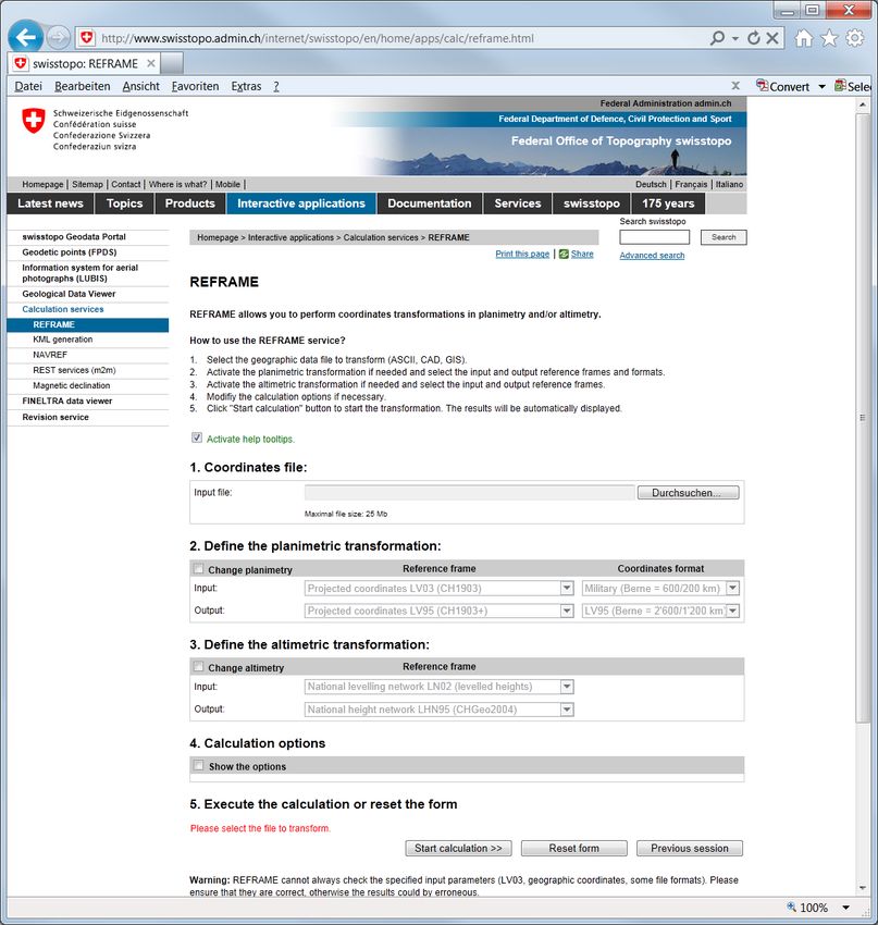
3. INTERNET SERVICES REALISED

In a second step, a set of Internet services has been developed:

3.1 Transformation Services

Transformation services as Machine to Human (M2H) service for all the common geo formats
and as Machine to Machine (M2M) service for real-time transformation in the federal
geoportal map.geo.admin.ch or for the Swiss positioning service swipos. In this way, swipos
can offer GNSS corrections for both reference frames

Figure 5: REFRAME transformation service

Matthias Kistler, Urs Marti, Jérôme Ray, Christian Baumann and Adrian Wiget (Switzerland)   7/12
Towards a Distortion Free National Spatial Data Infrastructure in Switzerland:
Approach, Developed Tools and Internet Services for the Change of the Reference Frame

FIG Working week 2015
From the Wisdom of the Ages to the Challenges of the Modern World
Sofia, Bulgaria, 17-21 May 2015
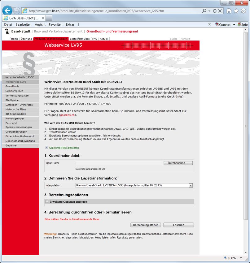
3.2 Interpolation Service

Interpolation services for the conversion / rectification of geo datasets on the very local level
with big distortions based on deformation grids

Figure 6: TRANSINT interpolation service

Matthias Kistler, Urs Marti, Jérôme Ray, Christian Baumann and Adrian Wiget (Switzerland)   8/12
Towards a Distortion Free National Spatial Data Infrastructure in Switzerland:
Approach, Developed Tools and Internet Services for the Change of the Reference Frame

FIG Working week 2015
From the Wisdom of the Ages to the Challenges of the Modern World
Sofia, Bulgaria, 17-21 May 2015
3.3 Visualisation Services for Survey Points and the Transformation Accuracy

Visualisation services for desktop and mobile devices, e.g. all the survey point site
descriptions with old and new coordinates and different metadata are available or a map with
the expected transformation accuracy for the whole country.

Figure 7: Visualisation service for survey points on national (red) and cantonal level (blue).
In the site description (see example right), coordinates of these points, which are distributed
all over Switzerland, are always available in both reference frames together with many
metadata information

Matthias Kistler, Urs Marti, Jérôme Ray, Christian Baumann and Adrian Wiget (Switzerland)   9/12
Towards a Distortion Free National Spatial Data Infrastructure in Switzerland:
Approach, Developed Tools and Internet Services for the Change of the Reference Frame

FIG Working week 2015
From the Wisdom of the Ages to the Challenges of the Modern World
Sofia, Bulgaria, 17-21 May 2015
Figure 8: Visualisation service for the transformation accuracy based on a statistical method
over control points distributed all over Switzerland (GNSS measured coordinates in com-
parison with transformed ones). Furthermore the cadastral authorities nominated so-called low
distortion areas (blue surfaces): in these areas, cadastre survey fulfils the higher accuracy re-
quirements related to the new global reference frame, so that measurements with GNSS
sensors can be done in an absolute way without having to respect the local situation

Matthias Kistler, Urs Marti, Jérôme Ray, Christian Baumann and Adrian Wiget (Switzerland)   10/12
Towards a Distortion Free National Spatial Data Infrastructure in Switzerland:
Approach, Developed Tools and Internet Services for the Change of the Reference Frame

FIG Working week 2015
From the Wisdom of the Ages to the Challenges of the Modern World
Sofia, Bulgaria, 17-21 May 2015
3.4 Download Service

Last but not least, different download services for DLLs and transformation datasets have also
been realised.

With these different tools, the georeferencing of the SDI of Switzerland can be easily
converted to the new reference frame LV95 in the next couple of years. About one third of 23
cantons (state level) have already transformed their SDIs successfully and for another third,
the preparation work has already been started.

Matthias Kistler, Urs Marti, Jérôme Ray, Christian Baumann and Adrian Wiget (Switzerland)   11/12
Towards a Distortion Free National Spatial Data Infrastructure in Switzerland:
Approach, Developed Tools and Internet Services for the Change of the Reference Frame

FIG Working week 2015
From the Wisdom of the Ages to the Challenges of the Modern World
Sofia, Bulgaria, 17-21 May 2015
REFERENCES

EMERY, P., RAY, J. UND ULRICH, D. (2013): GeoSuite - Modul TRANSINT und
  REFRAME. swisstopo Manual 10-d - Wabern bei Bern.
KISTLER, M. UND RAY, J. (2007): Neue Koordinaten für die Schweiz: Fertigstellung der
  nationalen Dreiecksvermaschung, neue Transformations-Software REFRAME und
  Eröffnung des Internet-Portals «Bezugsrahmenwechsel». Geomatik Schweiz 9/2007,
  Seiten 432 - 437.
KISTLER, M. & AL. (2014): Der neue geodätische Software-Werkzeugkasten GeoSuite für
  Monitoraufgaben in der Ingenieurvermessung. Poster für Ingenieurvermessung 2014 -
  ETH Zürich.
MARTI, U. UND NOCERA, R. (2003): FINELTRA - Affine Transformation von
  Lagekoordinaten mit finiten Elementen und Umrechnung von LV03 in LV95 und
  umgekehrt. swisstopo Manual 06-d - Wabern bei Bern.
RAY, J., MARTI U., UND KISTLER, M. (2009): Methoden und Werkzeuge für die
  Koordinatentransformation zwischen globalen und lokalen Bezugsrahmen und den
  Datenaustausch mit den Nachbarländern. Geomatik Schweiz 11/2009, Seiten 536 - 539.
RAY, J. (2009): REFRAME .NET / COM library - Developer's manual. swisstopo Report 09-
  07 - Wabern bei Bern.
RAY, J. (2012): REFRAME plug-in for FME 2.4. Manual swisstopo - Wabern bei Bern.
RAY, J. (2012): TRANSINT .NET / COM library - Developer's manual. swisstopo Report 12-
  15 - Wabern bei Bern.
VOGEL B., KISTLER, M. & AL. (2009): Aufbau der neuen Landesvermessung der Schweiz
  'LV95', Teil 13: Einführung des Bezugsrahmens ’LV95’ in die Nationale
  Geodateninfrastruktur. swisstopo Doku Nr. 21 - Wabern bei Bern.

BIOGRAPHICAL NOTES

-

CONTACTS

Master of Science ETH Matthias Kistler
Swiss Federal Office of Topography swisstopo
Geodesy Division
Seftigenstrasse 264
3084 Wabern - Berne
SWITZERLAND
Tel + 41 58 469 03 40
Fax + 41 58 469 04 59
Email: matthias.kistler@swisstopo.ch
Web site: www.swisstopo.ch

Matthias Kistler, Urs Marti, Jérôme Ray, Christian Baumann and Adrian Wiget (Switzerland)   12/12
Towards a Distortion Free National Spatial Data Infrastructure in Switzerland:
Approach, Developed Tools and Internet Services for the Change of the Reference Frame

FIG Working week 2015
From the Wisdom of the Ages to the Challenges of the Modern World
Sofia, Bulgaria, 17-21 May 2015
You can also read