USING GOOGLE MAP API FUNCTIONS TO CREATE
←
→
Page content transcription
If your browser does not render page correctly, please read the page content below
USING GOOGLE MAP API FUNCTIONS TO CREATE
APPLICATIONS USING GEOGRAPHIC SPATIAL DATA.
Ass. prof.d-r. Plamen Maldzhanski
1,Hristo Smirneski Blvd., 1046 Sofiq, Bulgaria
Phone: +359 888976924
WEB:http://www.uacg.bg/UACEG_site/acadstaff/viewProfile.php?lang=en&perID=424
E-mail:p_maldjanski@mail.bg

Key words: Google Maps API, geocoding, programme system.

SUMMARY

       The model describes Google Maps and his ability to create custom applications using
geographic spatial data. Describe the process of geocoding as a process of finding and associating
geographic coordinates with other geographical spatial data. Demonstrate the ability of the software
package created “Geodesy”, using Google Maps API functions with opportunities to address
navigation and search based on Google Maps.

        Created program package "Geodesy” is a modular, work with relational database and covers
a large area of real geodetic practice activities involving the processing of data from direct geodetic
measurements (aligned networks and surveying ), create digital models of relief, automated creation
of longitudinal and transverse profiles, activities associated with grading and other . Has its own
graphics editor compatible with AutoCAD and its own Windows browser to work with Internet
applications. Possibilities for setting and WEB-address navigation. Browser is compatible with the
common browser's (Internet Explorer and Morzila Firefox) and keep plagens built to work with
Java Script applications.

       Some of the most important operations implemented in the package for working with spatial
data and using Google Maps API functions are: using Google Maps key controls: move, set the
window, working with markers and information windows, search by address search defined by
geographical coordinates; refereed working with images, maps and hybrid maps. In development
are used Delphi programming language and Java Script. The code of the scripts is implemented
external to the application that allows its easy modification and maintenance of a change of API
functions.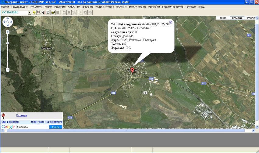
USING GOOGLE MAP API FUNCTIONS TO CREATE
APPLICATIONS USING GEOGRAPHIC SPATIAL DATA.
Ass. prof.d-r. Plamen Maldzhanski
1,Hristo Smirneski Blvd., 1046 Sofiq, Bulgaria
Phone: +359 888976924
WEB:http://www.uacg.bg/UACEG_site/acadstaff/viewProfile.php?lang=en&perID=424
E-mail:p_maldjanski@mail.bg

Key words: Google Maps API, geocoding, programme system.

        The use of geographic spatial data in a variety of amenities and creates opportunities for
visualization and use geographic information systems (GIS). Solve tasks related to the creation of
interactive maps in Internet applications, GIS tasks as an indication of the routes, information
searches by address, name and other keys. A facility for creating Internet-based applications,
possess the above qualities is Google maps API. This e provided by Google Earth Java Script
interface set of functions through which developers can use and manage their WEB-based
applications so as to create efficient and fully finished custom applications to work with geographic
spatial data. Via Google maps API user gets a powerful programming tools to create interactive
maps, access to the database of Google Earth and opportunities for rapid development of user
interface through which to carry out search operations through address geocoding, visualization of
geographic data, implement analysis and consultation.

      The main object in the Google maps API is object maps. Developed a mechanism for its
management as milestones include:

           •   inclusion of the Maps API JavaScript using the script tag;
           •   creating a DIV element with the name "map_canvas";
           •   creating JavaScript Object possessing basic properties of objects Maps, using the
               JavaScript function;

On (Fig. 1) shows Java script code Realizing the sequence of actions described above.

             function initialize() {
            var latlng = new google.maps.LatLng(-34.397, 150.644);
            var myOptions = { zoom: 8, center: latlng, mapTypeId: google.maps.MapTypeId.ROADMAP
             };
             var map = new google.maps.Map(document.getElementById("map_canvas"), myOptions);
            }

                                            (Fig.1)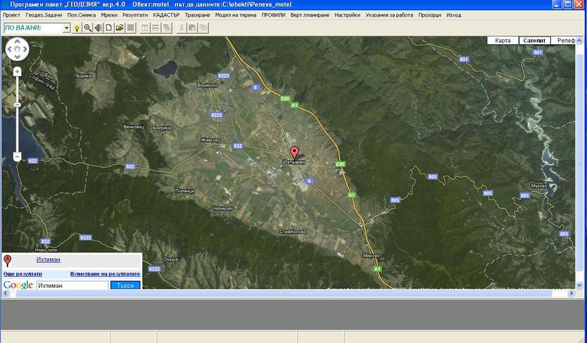
In the Google Maps API are available the following types of cards:
• MapTypeId.ROADMAP-displayed by default roadmap;
• MapTypeId.SATELLITE-shows satellite images from Google Earth;
• MapTypeId.HYBRID-shows a combination of maps and satellite images;
• MapTypeId.TERRAIN-Physiographically shows a map with relief depicted.
The most important controls available for managing the site maps are shown in Table 1.
Control Action
GLargeMapControl3D Zoom control. Place in the upper left corner by default
GLargeMapControl a simple zoom control.
GSmallMapControl less control to increase
GSmallZoomControl3D Contol a small increase. Used in small windows on the map
GSmallZoomControl control for a small increase
GScaleControl shows the scale of the map
GMapTypeControl buttons, allowing users to switch between types of cards
GHierarchicalMapTypeControl selection of input buttons and menu items
GOverviewMapControl collapsible overview map in the corner of the screen
GNavLabelControl dynamic label that the "address" the current Viewport
(Таble 1)
In the Google maps API provided opportunities for the use of markers (point objects on the
map where the user can set different cartographic symbols, and to make appropriate geocoding (the
association of geographical coordinates and Attribute information on the sites indicated on the map.
Facility Management allows the user to define its own sign system in the building of WEB-based
applications. This is achieved through management of the facility provided Gmarker and methods
for its management. In operations such as search by address, indicating the routes to other key can
derive information windows through which the user can manage the process of working with spatial
data.
In support of Google maps API is given special attention on the possibilities for drawing
polylines as a series of segments directly on the map. May indicate preferred colors, thicknesses and
shades for the line. The colors are in hexadecimal numeric HTML code, for example, instead of
using red # FF0000. Management is done through the site GPolyline.
GPolyline sites use browser options for drawing lines through the standard VRML (Virtual
Reality Mark Up Language).
The package “Geodesy” intended for solving various problems of geodetic practice, such as:
Adjustment of plans and elevation networks, creating DEM (digital models of relief), automation of
activities in the formation of trails and plotting longitudinal and cross sections, design planes,
transformations, coordinates activities related to creating and using spatial data and has developed a
module that allows the use of Google maps API for working with geographic data. The overall
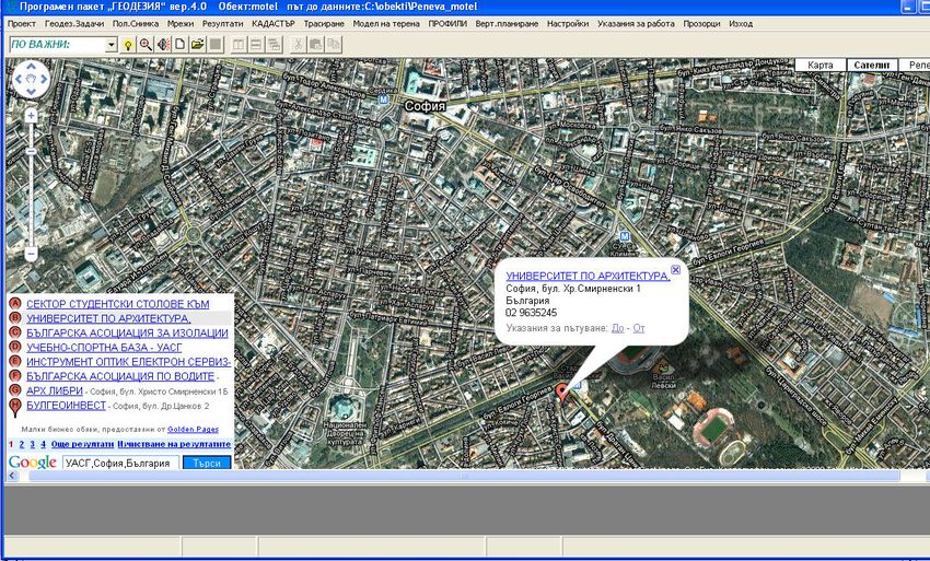
appearance of the application can be seen on (Fig. 2).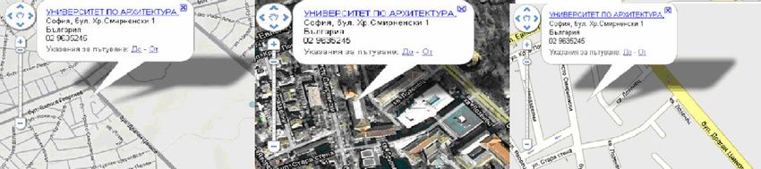
(fig.2)
        The interface acts as a browser application. Provides for the use of Google maps basic
controls, namely:
            • GLargeMapControl3D, allowing navigation (zoom in and move the box on the
               map). Visualized in the upper left corner of the window;
            • GmapTypeControl-buttons, allowing users to switch between types of cards.
               Located in the upper right corner of the window;
            • GoogleBar-seeking include the use of the information window in the lower left
               corner, which are not searchable by address, name and place access to the
               information server to Google.
        From the menu  geographical coordinates are introduced in the
coordinate system WGS-84 for subject searches and visualization of the object they are at the center
of the window specified by the object Gmarker.
        Basic operations with spatial data generated in the application package are:
            • Window displaying the content information: address and geographic coordinates for
               each point on the map on which the positioning is performed with two mouse clicks.
               (Fig. 3);
            • Search by address specified geographic object (using the geocoding data).
               Implemented by the search control GoogleBar recorded address or search keys.
               Information displayed on search results window (Fig. 4).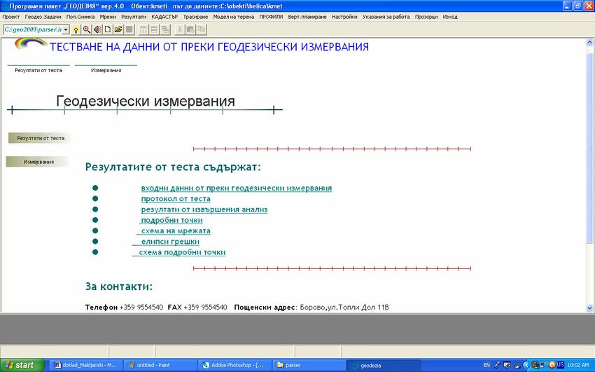
(Fig.3)

                                      (Fig.4)
       At every moment of working with geographical spatial data application allows switching
card types (road, satellite photographs, hybrid and relief). On (Fig.5) shows the types of information
obtained over the same area as a result of a rabora GmapTypeControl.
(Fig.5)
Prepared application allows the processing of data from direct geodetic measurements to be
carried out under geocoding and spatial data obtained to compare and analyze data from data
servers. Successfully prepare the data used for the purposes of the cadastre and investment design.
It was created by a special parser which builds XML database to work with remote access. (Fig.6)
(Fig.6)
Conclusions:
• Using the Google maps API programming provides an efficient unit for building
applications using spatial geographic data;
• For the geodetic practice the building applications combine opportunities for
practical implementation of the geocoding process as an information and provide
user features for working with GIS.
Literature:
[1] Google Maps API Concepts , http://code.google.com/intl/bg/apis/maps/documentation/
[2] Мaldzhanski,Pl., Software package "Geodesy" User's Guide,
http://share.acrobat.com/adc/document.do?docid=979b58ab-9c67-47b3-99c1-3e07199c95d2
[3] Мaldzhanski,Pl., Ways of encoding used in the visualization of geo-data, National Military
University "Vassil Levski", Scientific Session, noisy, 12, October 13, 2006You can also read