Postcodes Australia Product Guide - Version 2021.02.0
←
→
Page content transcription
If your browser does not render page correctly, please read the page content below
Postcodes Australia

Product Guide

Version 2021.02.0
Table of Contents

1 - Getting Started

Overview...............................................................4
Limitations.............................................................4
System Information...............................................4
Installation.............................................................5
Document Conventions.........................................6
Field Names in Schema Tables.............................6

2 - Layer Descriptions

Gazetted Suburbs versus Australia Post Listed
   Localities..........................................................8
Generation of Precisely’s Postcodes
   Boundaries.......................................................8
Table Structure......................................................9
Implementation of Incremental Updates..............11
Population & Income Data from the 2016 ABS
   Census...........................................................12

3 - Notices and Product
Support

Notices................................................................14
Product Feedback and Support...........................15

Postcodes Australia            Product Guide                                 2
1 - Getting Started

In this section
Overview.....................................................................................................4
Limitations..................................................................................................4
System Information.....................................................................................4
Installation..................................................................................................5
Document Conventions..............................................................................6
Field Names in Schema Tables..................................................................6

Postcodes Australia           Product Guide
Overview
      Postcodes Australia is a spatial data product that has been derived from a number of sources,
      including:
      • Advice from Australia Post - Address Management Centre
      • Locality boundaries supplied by PSMA Australia Ltd

Limitations
      Whilst every attempt is made to represent the postcode boundaries for Australia as accurately as
      possible, Precisely is constrained to using what information is available at the time of data production.
      However, Precisely intends to release updates to the Postcodes product, at least quarterly, to address
      changes as they occur.

System Information

Metadata

      Metadata conforming to ANZLIC standard is supplied in XML file format for the Postcodes product
      range. These files can easily be viewed in a Web browser such as Microsoft Internet Explorer.
      Alternatively, XML viewers are available from third party sources that readily display the hierarchical
      structure of the metadata information.

Projection/Datum

      The Postcodes table is provided on the GDA94 datum and projected over a longitude / latitude
      coordinate system. This datum is adopted as the national standard for all spatial data.

Postcodes Australia   Product Guide                                                                               4
This is a geocentric datum which allows the projection to be used at a global level and facilitates, for
example, compatibility with positions derived from Global Positioning Systems (GPS satellites).
Installation
Postcodes Australia is supplied in the form of compressed files that must be extracted before use.
Before downloading the .zip file and extracting, ensure that there is enough storage space for the
data. As a guide, the zip file for the whole of Australia is about 140MB, and the extracted data requires
approximately 200MB of disk space (these sizes may increase in future releases).
To install the product, download the zip file, and extract the zipped data to your preferred location.
Note: Ensure that all license agreements are read and understood before installing the data.
Customised and other versions of Postcodes Australia are also supplied as zipped files. If you
intend using Postcodes Australia data across a network, ensure that the correct licensing
agreements have been set up. For more information regarding these licensing agreements,
contact your local Precisely office or reseller.
Postcodes Australia Product Guide 5Document Conventions
The following conventions are used throughout this document:
Text Style Significance
Underlined Emphasis
Italics Document or chapter titles, or references to specific texts
Bold Field or file name references in the text
Underlined bold Commands or actions
Typewriter font, shaded background Keyboard input or screen output
Field Names in Schema Tables
Field names in schema tables are documented in upper-case letters. The appearance of field names
in the actual product may differ from this convention.
Postcodes Australia Product Guide 62 - Layer Descriptions In this section Gazetted Suburbs versus Australia Post Listed Localities.........................8 Generation of Precisely’s Postcodes Boundaries......................................8 Table Structure...........................................................................................9 Implementation of Incremental Updates...................................................11 Population & Income Data from the 2016 ABS Census...........................12 Postcodes Australia Product Guide
Gazetted Suburbs versus Australia Post Listed
Localities
There is currently limited correlation between the state jurisdiction official gazetted suburb and
localities, and the localities listed by Australia Post on its website to describe the delivery area for a
postcode. The gazetted suburb and localities are formally recognised boundaries defined by state
government, whilst Australia Post's localities can include these, but also incorporate local and alias
locality names. (Some of these names are historical but many are also created internally by Australia
Post to facilitate mail delivery.)
Generation of Precisely’s Postcodes Boundaries
Precisely's postcode boundaries are generated by combining the postcode and locality information
from the Australia Post postcode listing, with the locality information from Precisely’s Suburbs and
Localities product. The locality information in the Suburbs and Localities product contains both
gazetted suburbs and non-gazetted Localities, and is based on source from PSMA Australia Pty
Ltd's Suburbs and Localities data.
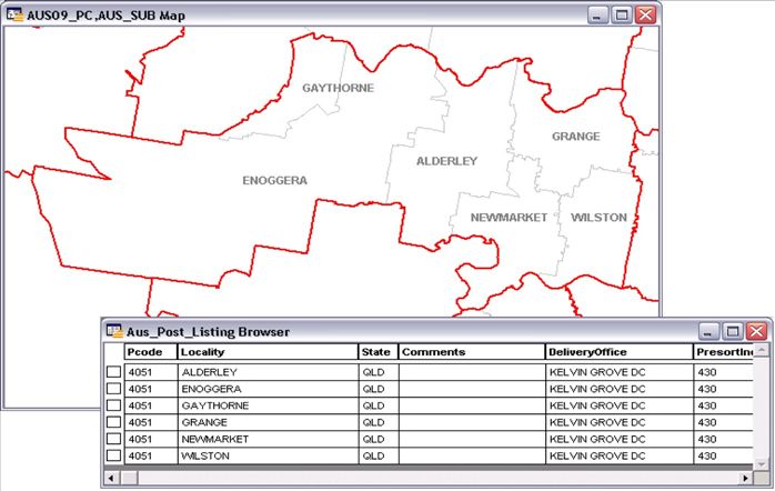
The illustration below shows how the boundary of postcode 4051 is formed by the suburb boundaries
listed.
Note: In areas where no gazetted suburbs exist, the locality boundaries are used to facilitate
full, nationwide postcode coverage.
Postcodes Australia Product Guide 8Some of the postcodes listed in the Australia Post listing are not included in the Postcodes Australia
product. Although there are exceptions, the types of postcodes that are not generally included are:
• PO Boxes that do not relate to a Delivery Area
• Large Volume Receivers (LVR) and Special Mailings (for example, Competition Mail)
• Postcodes that relate to the Antarctic Division stations
Table Structure
Field Name Data Type Index Description
(Length)
POSTCODE CHAR (4) Yes Postcode
LOCALITY CHAR (40) No Associated locality
STATE CHAR (3) No State abbreviation
TOTAL_POPULATION INTEGER No Total population
Postcodes Australia Product Guide 9Field Name Data Type Index Description
(Length)
MEDIAN_PERSONAL_INCOME INTEGER No Median personal income
MEDIAN_HOUSEHOLD_INCOME INTEGER No Median household income
DWELLINGS_OCCUPIED_PRIVATE INTEGER No Number of occupied private dwellings
POPULATION_DENSITY FLOAT No Population per square km
PC_UFI INTEGER Yes Unique identifier
Field Name Data Type (Length) Index Description
POSTCODE CHAR (4) Yes Postcode
LOCALITY_INDEX CHAR (40) Yes Associated locality
STATE CHAR (3) No State
Note: The LOCALITY_INDEX table is also supplied in the form of a comma separated values
file (csv) and text file (txt).
The Incremental Postcodes table contains postcode regions for those areas that have changed
between the previous release and the current release.
The Incremental table has the same structure as the AUS_PC table, but with the additional field
CHANGE_TYPE which shows the changes according to the following table:
Postcodes Australia Product Guide 10Field Name Value Description
CHANGE_TYPE I Insertion
UA Attribution Update
UB Both geometry and attribution update
UG Geometry Update
D Deletion
Deleted regions are colored purple to simplify visual identification and have the geometry and
attribution of the previous Postcodes release.
Implementation of Incremental Updates
An incremental update can be carried out using the following procedure:
1. Select records from the previous release of Postcodes data where the POSTCODE values match
those of the Incremental table and the CHANGE_TYPE = “D” or “U” (Deletion or Update
respectively)
2. Delete the selected records from the old Postcodes data.
3. Select from the new Postcodes incremental table where the CHANGE_TYPE = “I” or “U” (Insertion
or Update respectively).
4. Append the selected records to the old Postcodes data. The resulting table will contain the
updates for the current version of Postcodes, but will retain the old table structure.
Postcodes Australia Product Guide 11Population & Income Data from the 2016 ABS
Census
The following demographic fields are available in the Postcodes table:
TOTAL_POPULATION
• Calculates the total number of persons within a postcode by summing whole Mesh Block areas
and apportioning partial Mesh Blocks that fall within multiple postcodes based on area.
DWELLINGS_OCCUPIED_PRIVATE
• Calculates the total number of Occupied, Private Dwellings within a postcode by summing whole
Mesh Blocks and apportioning partial Mesh Blocks that fall within multiple postcodes based on
area.
MEDIAN_PERSONAL_INCOME
• Calculates the approximate median personal income of a postcode using a weighted average of
persons earning income within associated SA1s.
MEDIAN_HOUSEHOLD_INCOME
• Calculates the approximate median household income of a postcode using a weighted average of
household income within associated SA1s.
POPULATION_DENSITY Calculates the population per square kilometer of postcodes using the
area of a postcode divided by the TOTAL_POPULATION calculated above.
Mesh Blocks are the smallest geography in the new ASGS and contain approximately 30-60
dwellings. Please see http://www.abs.gov.au/ausstats/abs@.nsf/mf/2074.0for more information.
SA1– Statistical Area Level 1, the smallest geographical unit for which ABS census data is currently
available. Please see
http://www.abs.gov.au/ausstats/abs@.nsf/Lookup/2901.0Chapter23002016#SA1 for more
information.
Postcodes Australia Product Guide 123 - Notices and Product Support In this section Notices......................................................................................................14 Product Feedback and Support................................................................15 Postcodes Australia Product Guide
Notices
      Information in this document is subject to change without notice and does not represent a commitment
      on the part of the vendor or its representatives. No part of this document may be reproduced or
      transmitted in any form or by any means, electronic or mechanical, including photocopying, without
      the written permission of Precisely, 2 Blue Hill Plaza, #1563, Pearl River, NY 10965.
      ©   2021 Precisely. All rights reserved.
      See www.precisely.com for information about our valuable trademarks.
      End User License Agreement (EULA)
      Use of this product is governed by the terms of an end user license agreement (EULA). Please
      review this agreement carefully. You can also review the full terms of the EULA by visiting
      https://www.precisely.com/legal/licensing/data-end-user-license-agreement.
      License

                                                                                                 http://www.psma.com.au/
                                       Incorporates or developed using data ©2020 PSMA
                                       Australia Limited, Copyright and Disclaimer Notice
                                       https://psma.com.au/psma-data-copyright-and-disclaimer/

                                       ©Australian Postal Corporation 2020. The Postcode http://www.auspost.com.au
                                       Boundary mapping information is Australian Postal
                                       Corporation Copyright.

Postcodes Australia    Product Guide                                                                                       14
Product Feedback and Support
Contact our Support team (software.support@precisely.com) for product support and additional
product information. You can also submit your innovative ideas or comment on existing submissions
in a way that is visible to all participants via our Support site (https://support.precisely.com). This
site also includes information about our complete portfolio of Data products.
Postcodes Australia Product Guide 152 Blue Hill Plaza, #1563 Pearl River, NY 10965 USA www.precisely.com © 2000, 2021 Precisely. All rights reserved.
You can also read