Troon (South Beach) Bathing water profile
←
→
Page content transcription
If your browser does not render page correctly, please read the page content below
Bathing water profile:
Troon (South Beach)
Bathing water:
Troon (South Beach)
EC bathing water ID number:
UKS7616060
Location of bathing water:
UK/Scotland/North Ayrshire
(Map1)
Year of designation: 1987
Bathing water description
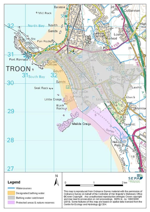
Troon (South Beach) bathing water is located on the Ayrshire coast at the Northern most point of Ayr Bay
adjacent to Troon town. The beach is approximately 2 km long and is mainly sandy with rocky outcrops at
both the northern and southern ends of the bay (Map 1). The sand dunes at the southern end of beach
continue along to the coastline as far as Prestwick. Troon offers spectacular views of the Ailsa Craig and
Lady Isle. It was designated as a bathing water in 1987.
During high and low tides the approximate distance to the water’s edge can vary from 0–320 metres. The
sandy beach slopes gently towards the water. For local tide information see:
http://easytide.ukho.gov.uk/EasyTide/
Our monitoring point for taking water quality samples is located towards the Northern end of the bay and
South of the war memorial (Grid Ref NS 32070 30620) as shown on Map 1.
Monitoring water quality
1
Please visit our website for details of the current EU water quality classification and recent results for this
bathing water.
During the bathing season (1 June to 15 September), designated bathing waters are monitored by SEPA
for faecal indicators (bacteria) and classified according to the levels of these indicators in the water. The
European standards used to classify bathing waters arise from recommendations made by the World
1
http://apps.sepa.org.uk/bathingwaters/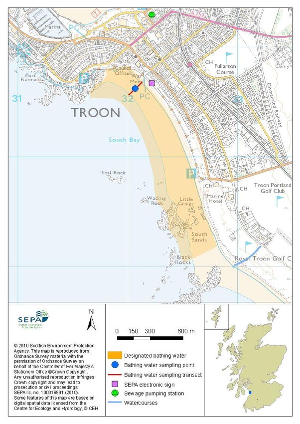
Health Organisation and are linked to human health. More information on bathing water monitoring, health
                                                    2
      and classification can be found on our website .
      Risks to water quality
      In general, most natural waters will be affected to some extent during and following rainfall as pollutant
      loads may be increased due to run-off from agricultural or urban land in the catchment. In addition, at
      some locations waste water discharges from combined sewer overflows, which then drain into the bathing
      water and can reduce water quality.
      Faecal pollutants can come from human sewage, farming activities and livestock (e.g. cattle, sheep),
      industrial processes, surface water urban drainage, domestic animals (e.g. dogs) and wildlife (e.g. birds)
      and can enter bathing waters via:
              direct discharges into the marine environment at, or in the vicinity of, the beach;
              the freshwater network draining into a bathing water, which can be prone to elevated bacterial
              levels as a result of diffuse pollution and/or point source inputs upstream.
      The potential relevant pollution sources at, or near, this bathing water are highlighted on Map 1.
      The principal risks and source of wet weather driven short term pollution at this bathing water arise from
      surface water urban run-off. These events are expected to last 1–2 days depending on the duration of the
      rainfall.
      Our regulatory and scientific assessment indicates that there are no significant pollution inputs to this
      bathing water under normal conditions.
      Bathing is not advisable during or following (one or two days after) rainfall. Bathing or swimming after
      storms, floods or heavy rainfall should be avoided as the risk of illness following short term water pollution
      is increased.

      Cyanobacteria (blue-green algae)
      Marine waters are not at risk of overproduction of cyanobacteria.

      Algae
      Current information suggests that this bathing water is not at risk of overproduction of macroalgae
      (seaweed) or phytoplankton. However, at any time of the year and particularly after storms, a considerable
      amount of seaweed can become stranded on the beach. Under the right conditions accumulated seaweed
      can rot producing grey/black fluid. The rotting seaweed can also generate offensive odours. This is an
      entirely natural process.

      Jellyfish
      There is a possibility of increased numbers of jellyfish in the water during the summer months. This is a
      naturally occurring phenomenon. Although there are a few stinging species common to the UK, most are
      harmless. The Marine Conservation Society advises to ‘look but don’t touch’.

      Daily water quality forecasts
      Troon (South Beach) bathing water is part of our daily water quality prediction and signage network.
      Throughout the bathing season we display daily water quality predictions on the electronic message sign
                                                                                3
      (Map 1). These water quality predictions are also available on our website or via the Beachline phone
      number (08452 30 30 98).

2
    http://apps.sepa.org.uk/bathingwaters/SamplingResults.aspx
3
    http://apps.sepa.org.uk/bathingwaters/Predictions.aspx
Map 1: Troon (South Beach) bathing water

Map 2: Catchment draining into Troon (South Beach) bathing water
Catchment description
                                                                                        2
    The catchment draining into Troon (South Beach) bathing water extends to 4.3 km . The catchment is
    fairly low-lying with a maximum elevation of 30 metres in the east. The area is a mixture of urban (50%)
    and rural (50%) land use. The area close to the beach is mainly urban while the surrounding area is
    primarily grassland. Troon town is immediately adjacent to the bathing water, and is the main population
    centre within the catchment (Map 2).
    Average summer rainfall for the region is 392 mm compared to 331 mm across Scotland as a whole.
    There are no direct freshwater inputs into the designated bathing water, but the Pow Burn discharges to
    sea to the south of the bathing water and the Darley Burn into Troon’s north bay. These burns may be
    prone to elevated bacterial levels as a result of diffuse pollution upstream during periods of wet weather
    but are not thought to have a significant affect on the bathing water.

    The southern end of the Troon bathing water has been designated as a Site of Special Scientific Interest
    for several important biological features:

            The fixed sand dunes and the dune grassland and scrub at Royal Troon golf course which are
            botanically rich and diverse, and are the best example of this habitat type in the country.
            The sandy beach and rocky outcrops are of significance for the numbers of passage/wintering
            wildfowl and waders, particularly curlew. Meikle Craigs is also an important gull roost and moulting
            area for eider ducks and supports a large number of wading birds during the summer months.

                                                                        4
    Please see Scottish Natural Heritage's information service website for further information about these
    protected areas.
    The Scottish Government has designated the southern part of the catchment as a greenbelt area.

    Measures to improve bathing water quality
    High quality bathing waters are important so that people can enjoy Scotland’s environment safely. They
    are also important for Scotland’s tourism industry.
    Recent years have seen considerable improvements in Scotland’s bathing water quality, not least due to
    substantial investment in the sewerage system. SEPA and our partners are fully committed to continuing to
    improve bathing water quality.
    Improving diffuse pollution from agricultural sources
    Diffuse pollution from agricultural sources is normally the result of cumulative inputs of pollutants from
    several different sources on farms within the catchments draining to the bathing water. Consequently,
    tackling diffuse agricultural pollution requires concerted action across catchments. We will ensure this by
    working with farmers to raise awareness about the requirement to prevent and reduce pollution, and to
    help them identify appropriate actions for doing so.

    To help co-ordinate our work to encourage and ensure action, SEPA participate in the Diffuse Pollution
                                 5
    Management Advisory Group (DPMAG), which is a partnership of relevant authorities, land manager
    representatives and voluntary organisations.
    The Scottish Government has also brought together nine public bodies to form Scotland’s Environmental
                        6
    and Rural Services (SEARS). This partnership will contribute to implementing plans for tackling diffuse
    pollution by providing co-ordinated education and advice to rural land managers.
    Additional targeted efforts will be made to improve management of diffuse pollution within catchments
    identified as ‘priority’ catchments. These are catchments where the scale of the pollution reduction needed
    will require planned and targeted actions to be identified and discussed with farmers concerned.
    Assistance will be given in these areas to identify pollution hotspots, and one-to-one advice will be

4
  www.snh.org.uk/snhi
5
  http://www.sepa.org.uk/environment/water/river-basin-management-planning/who-is-involved-with-rbmp/dpmag/
6
  www.sears.scotland.gov.uk
provided on following the agricultural codes of good practice, which in themselves lead to compliance with
these regulations. Action in priority catchments will be phased.
There are no significant agricultural activities ongoing in this catchment.
Improving pollution from sewage and other discharges
Most waste water collection and treatment services in Scotland are provided by Scottish Water. It has
invested substantially in waste water collection and treatment provision over recent years to protect public
health and the environment. Public investments in the sewerage network and in treatment works will
continue to be co-ordinated through the national investment and planning process for Scottish Water,
known as ‘Quality and Standards’.
Improvements to the sewerage system have led to a significant reduction in the level of faecal indicators in
the Troon (South Beach) bathing water under normal conditions.
A recent Scottish Water study has predicted that there are no public sewerage assets which are likely to
prevent this bathing water achieving the revised Bathing Waters Directive standards. The study has
concluded that improvements to Scottish Water assets are not required.
There are no authorised private discharges that are considered to pose a threat to the water quality of this
bathing water.
Improving pollution from diffuse urban sources
Urban diffuse source pollution comes from rainwater falling onto urban areas (roads, pavements, yards
and roofs) becoming contaminated with pollutants on those areas, washing into surface water drains and
discharging from those drains to the water environment.
Tackling this type of pollution requires substantial changes in the way urban areas are drained, and efforts
to reduce the quantity of pollutants deposited on urban surfaces. Since the mid 1990s, Sustainable Urban
Drainage Systems (SUDS) have increasingly been used to drain new developments. They are designed to
avoid pollution of the water environment and include permeable surfaces that allow infiltration of rainwater
into the ground, slowing the rate at which it drains to the water environment and trapping and breaking
down pollutants. Artificial ponds or wetlands provide a final stage of treatment. Local authorities, Scottish
Water and SEPA are working together to co-ordinate efforts to tackle pollution from diffuse urban sources,
incorporating SUDS into local plans and encouraging partner organisations to retrofit SUDS where
possible.
The Darley Burn which flows into North Bay at Barassie is not known to be significantly affected by run-off
from the urban area through which it runs.
Responding to pollution incidents
Although rare, pollution incidents affecting bathing water quality can happen. Pollution incidents tend to be
unpredictable, for example a slurry spill or sewage network failure, and can result in elevated levels of
faecal indicators.
To report a possible pollution incident please use our 24 hour pollution hotline (0800 807060). In response
we will investigate the incident and contact other relevant organisations. That may include Scottish
Ministers, Scottish Water, the local authority and the relevant health board. Where necessary measures
will be put in place to resolve the problem.
Whenever our routine sampling of bathing waters identifies elevated levels of faecal indicators there is an
immediate response to check all relevant potential sources and major discharges in the immediate
catchment, as well as our hydrometric information to determine whether the levels may be due to high river
flows. Follow-up microbiology sampling is also undertaken of the bathing water and local water courses.
If beach users or bathers are considered to be at risk the local authority will warn the public by erecting
7
signs at the bathing water. Information will also be available on our website .
Other pollutants at the beach may include plastics and litter. Beach users are encouraged to use the bins
provided or to take litter home. Beach cleaning and litter clean-up is maintained for this bathing water by
South Ayrshire Council.
7
http://apps.sepa.org.uk/bathingwaters/Predictions.aspxContact details and sources of more information
SEPA Ayr office South Ayrshire Council
31 Miller Road Burns House
Ayr Burns Statue Square
KA7 2AX Ayr
01292 294000 KA7 1UT
01292 611130 01292 618222
www.sepa.org.uk environmental.health@south-ayrshire.gov.uk
www.south-ayrshire.gov.uk.
Pollution Hotline Scottish Government
0800 80 70 60 Victoria Quay
24 hours per day, 7 days per week Edinburgh
EH6 6QQ
Keep Scotland Beautiful 0131 244 0396
01786 471333 eqcat@scotland.gsi.gov.uk
beach@ksbscotland.org.uk www.scotland.gov.uk/Topics/Environment/Water/15561/bathingwaters
www.keepscotlandbeautiful.org
Further information about the condition of our water environment and the actions needed to deliver
improvement can be found in:
the Scotland river basin management plan
http://www.sepa.org.uk/environment/water/river-basin-management-planning/
the Clyde area management plan http://www.sepa.org.uk/environment/water/river-basin-
management-planning/who-is-involved-with-rbmp/area-advisory-groups/clyde/
Good Beach Guide: www.goodbeachguide.co.uk
Blue Flag and Seaside Awards: www.keepscotlandbeautiful.org/coastal
Version Control
Version number: Date: Next review due:
1.1 April 2013
1.2 April 2014
1.3 June 2015You can also read