Tsunami Warning and Mitigation Systems to Protect Coastal Communities - Tsunami Early Warning and Mitigation System in the North-Eastern Atlantic ...
←
→
Page content transcription
If your browser does not render page correctly, please read the page content below
FACTSHEET
                                             2020

       Tsunami Warning and Mitigation
Systems to Protect Coastal Communities

    Tsunami Early Warning and Mitigation System
 in the North-Eastern Atlantic, the Mediterranean
                and Connected Seas (NEAMTWS)
                                      2005–2020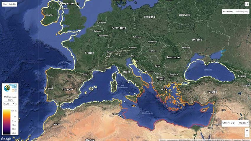
This Fact Sheet describes the development and main elements of ICG/NEAMTWS. In particular,
                      BACKGROUND                 it highlights the achievements, and contributions of NEAMTWS to disaster risk reduction, UN
                                                 Decade of Ocean Science for Sustainable Development and Sustainable Development Goals. It
                                                 also captures the overall governance, status, challenges and opportunities in the further development
                                                 of NEAMTWS.
                                                 Following the disastrous 2004 tsunami, in which over 230,000 lives were lost around the Indian
                                                 Ocean region, the Intergovernmental Oceanographic Commission (IOC) of UNESCO was mandated
                                                 by its Member States to facilitate the expansion of global coverage of Tsunami Warning and Mitigation
                                                 Systems (TWS), and to coordinate the establishment of the Tsunami Early Warning and Mitigation
                                                 System in the North-Eastern Atlantic, the Mediterranean and Connected Seas (NEAMTWS).
                                                 During the Twenty-third Session of the IOC Assembly (IOC-XXIII/3 held from 21 to 30 June 2005,
©shutterstock/EQRoy

                                                 the ICG/NEAMTWS was formally established through Resolution XXIII-14.
                                                 The need to develop NEAMTWS was recognized early in the European Council Conclusions of
                                                 December 2007 (15479/07) on the development and establishment of Early Warning Systems in the
                                                 EU, on the establishment of an Early Warning System for tsunamis in the North-East Atlantic and the
                                                 Mediterranean region, and in the Council Conclusions on Reinforcing the Union’s Disaster Response
                                                 Capacity – towards an integrated approach to managing disasters of June 2008 (7562/08).
                                                 To make meaningful progress, countries must share and sustain existing geophysical and sea-level
                                                 data streams in the required time and space resolution. There is a need to continuously improve the
                                                 tsunami detection and forecast system. Civil Protection Agencies and other stakeholders need to
                                                 play a more active role. There is an increasing need to focus on education and awareness raising
                                                 in NEAM region. Community Tsunami Readiness should be an important part of the equation to
                                                 addressing tsunami risk in the region.
                                                 The benefits and contributions of Tsunami Early Warning and Mitigation Systems to society and its
                                                 governance are next presented in that order.

                           ● Benefits and Importance of Tsunami Early Warning System
                           An effective Tsunami Early Warning System (TEWS) save lives, reduces loses and damages. TEWS are key
                           elements of disaster risk reduction. Tsunami are ‘short-fused’ hazards that can impact coastal communities within
                           minutes, if the tsunami trigger is located close to the target shoreline. If the source is located far away, the tsunami
                           may arrive within several hours. In most cases, tsunamis arrive much faster than hurricanes or typhoons, and
                           there is far less warning time than even the short time there is for riverine flooding. This requires extremely rapid
                           threat assessment and warning of communities, which is both technically and practically challenging (IOC, 2018).

                           ● ICG/NEAMTWS Contributions to UN Decade of Ocean Science for
                             Sustainable Development (2021-2030)
                           The NEAMTWS will contribute to the UN Decade of Ocean Science for Sustainable Development 2021-2030, in
                           particular by responding to the needs of society for a “safe ocean” where people are protected from ocean hazards.

                           ● ICG/NEAMTWS Contributions to Sendai Framework for Disaster Risk
                             Reduction (2015-2030)
                           NEAMTWS contributes to Target 7 of the Sendai Framework for Disaster Risk Reduction (2015-2030) which
                           calls to “substantially increase the availability of and access to multi-hazard warning systems and disaster risk
                           information and assessments to the people by 2030”. IOC provides assistance to countries to develop their
                           national Tsunami Warning Centres within a multi-hazard framework, and for maximizing community response
                           through creation of education and awareness.
                           The framework below shows how ICG/NEAMTWS is structured on the three Early Warning and Mitigation Systems
                           pillars, the broad foundation basis and its contributions to the UN Decade of Ocean Science for Sustainable
                           Development, the Sendai Framework and SDGs.
                      2   Tsunami Early Warning and Mitigation System in the North-Eastern Atlantic, the Mediterranean and Connected Seas (NEAMTWS) 2005–2020
UN OCEAN DECADE SENDAI FRAMEWORK FOR DISASTER RISK REDUCTION (2015-2030)
(2021-2030) SDG
Target 7- Multi-Hazard Early Warning System
Safe Ocean Regional Tsunami Early Warning and
Societal Benefit Mitigation Systems Pillars Foundations
NEAMTWS
NEAMTWS Risk Assessment and
Reduction Research
Interoperabilityy
IOTWMS
Detection, Warning
and Dissemination Capacity
CARIBE-EWS Building
Education, Awareness
Sustainability
PTWS and Response
IOTWMS: Indian Ocean Tsunami Warning and Mitigation System
CARIBE-EWS: Caribbean Early Warning System
PTWS: Pacific Tsunami Warning System
● Tsunami hazard, exposure and risk in NEAM region
A few decades ago, it was believed that the Mediterranean Sea and the Indian Ocean were at lesser risk for tsunamis
than the Pacific basin. The 2004 tsunami put an end to this myth. The Mediterranean has experienced one of the first
ever documented tsunamis triggered by the Bronze Age eruption of the Thera volcano. In 365 AD, a tsunami triggered
by a magnitude over 8.5 earthquake in Crete had devastating impacts across the entire Eastern Mediterranean, notably
destroying Alexandria as a world city.
The 1755 Lisbon earthquake triggered a tsunami with tens of thousands of deaths locally, but also in Spain and Morocco.
This event changed the philosophical thinking about natural disasters for ever since. The tsunami effectively ended the
reign of Portugal as a leading world power. In the 20th Century, the 1908 Messina tsunami killed tens of thousands, while
the 1956 Amorgos tsunami reached elevations up to 20m, in steep local rock faces. Already in 2012, the probability of
tsunamis exceeding 1 metre in the Mediterranean in the next 30 years was assessed as close to 100%. In the last few
years, several tsunamis with heights less than 1.5m have been recorded in the NEAMTWS region . The most recent of
which hit Southern Crete on 2 May 2020. Just as observed in Pacific ports, even small tsunamis in the Mediterranean can
trigger large scale whirlpool motions in small ports, and currents which may be deadly.
It is estimated that the NEAMTWS Low Elevation Coastal Zone (LECZ) (< 10 m height) is home to about 116 million
inhabitants. The numbers increase substantially during the tourist season. The figures below show the LECZ coastal
population for the entire NEAM region and the Mediterranean and connected seas region. In most cases, there may not
be sufficient time for warnings to reach all persons at risk, so preparedness and education on recognising the harbinger
tsunami signs and self-evacuation are important and save lives.
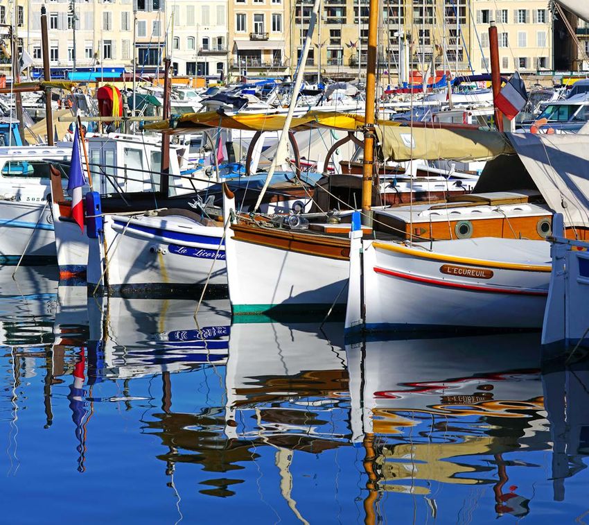
In the global context, with 1,403 million international arrivals in 2018, the Mediterranean has become the world’s primary
tourist destination the Mediterranean countries of Southern Europe contribute 286.2 million arrivals, to which should be
added the 23.9 million from North African countries and 63.6 million in the Middle East (UNWTO, 2019).
© UNESCO 2014
© UNESCO 2014
Tsunami Early Warning and Mitigation System in the North-Eastern Atlantic, the Mediterranean and Connected Seas (NEAMTWS) 2005–2020 3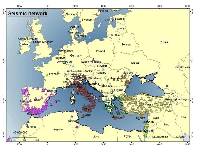
NEAM Region Coastal Population Map
GREENLAND
SEA
BARENTS
SEA
150k
90k
207k
94k 1.2M
NORTH 390k
Coastal Zone Population in 2018 250k 1.3M
SEA
Area of circle is proportional to the number of inhabitants 920k 1.0M
living below 10m along coastlines monitored by NEAMTWS 220k 380k
3.0M 1.1M 390k
5 million 1 million 100,000 Low Countries
15.6M below 10m
5m Area below each line represents percent
2m of population subject to inundation with a Po Valley 250k
1m sea level rise of 1, 2 or 5m 1.8M below 10m
Coastal elevations below 10m 300k
690k BL ACK S E A
400k 600k 1.8M
314k
NB:-The mapping analysis does not consider seasonal variability in 430k 340k
580k
population associated with tourism activities 440k 1.1M
290k 1.3M 510k
530k 700k
130k MEDITERRANEAN
750k SEA 470k
370k 340k
AT L A N T I C
Nile Delta
OCEAN 134k
38M below 10m
110k
This map is schematic and does not reflect exact boundaries, nor are all islands plotted or highlighted.
The designations employed on this map do not imply the expression of any opinion whatsoever on the part of
1.0M the Secretariats of UNESCO and IOC concerning the legal status of any country or territory, or its authorities, or
concerning the delimitation of the frontiers of any country or territory.
Produced by the Intergovernmental Oceanographic Commission of UNESCO. Map and analysis by Beehive Mapping.
IOC-UNESCO 2020
4 Tsunami Early Warning and Mitigation System in the North-Eastern Atlantic, the Mediterranean and Connected Seas (NEAMTWS) 2005–2020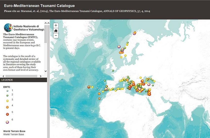
Mediterranean –Black Sea Coastal Population Map
Rostov
Nantes Odessa
Venice
Bordeaux
Marseille Split
Livorno Constanţa
BL AC K S E A
Bilbao Monaco Rome
Barcelona Durrës Istanbul
Thessaloniki
Samsun Batumi
Valencia Naples
Cagliari
Lisbon
Izmir
Seville Tunis
Málaga Algiers Annaba Icel
Athens
Cádiz
Tangier
Sfax MEDITERRANEAN
Beirut
SEA
Casablanca Haifa
Tripoli Misrata Alexandria
Benghazi
The mapping analysis does not consider seasonal Cairo
Coastal Zone Population in 2018
variability in population associated with tourism activities
Area of circle is proportional to the number of inhabitants
living below 10m along coastlines monitored by NEAMTWS
2 million 1 million
100,000
5m Area below each line represents percent
2m of population subject to inundation with a This map is schematic and does not reflect exact boundaries, nor are all islands plotted or highlighted.
1m sea level rise of 1, 2 or 5m The designations employed on this map do not imply the expression of any opinion whatsoever on the part of
the Secretariats of UNESCO and IOC concerning the legal status of any country or territory, or its authorities, or
Coastal elevations below 10m concerning the delimitation of the frontiers of any country or territory.
Produced by the Intergovernmental Oceanographic Commission of UNESCO. Map and analysis by Beehive Mapping.
IOC-UNESCO 2020
About the NEAM Coastal Population Maps
The maps identify coastal populations living below 10m elevation, which might be at risk of inundation under three sea level rise scenarios: 1m, 2m and 5m. The area of each circle is proportional to the number of inhabitants living below 10m, while the three
lines divide the total area of the circle, and hence the total coastal population, into those affected by sea level rises of 1, 2 and 5 m. The dividing lines are arranged from the bottom to the top of each circle. The circles are centered on areas of maximum population
Tsunami Early Warning and Mitigation System in the North-Eastern Atlantic, the Mediterranean and Connected Seas (NEAMTWS) 2005–2020
density that will be affected by a 1m sea level rise. The analysis does not consider seasonal variability in population associated with tourism activities. It also does not consider existing flood mitigation systems such as dikes and river barriers. In this case, there
5
might be population centers depicted on the map that are at considerably less ‘exposed’ than it might appear. Maps are based on the CoastalDEM 1.1 (www.climatecentral.org) and the LandScan 2018 global population database (www.landscan.ornl.gov).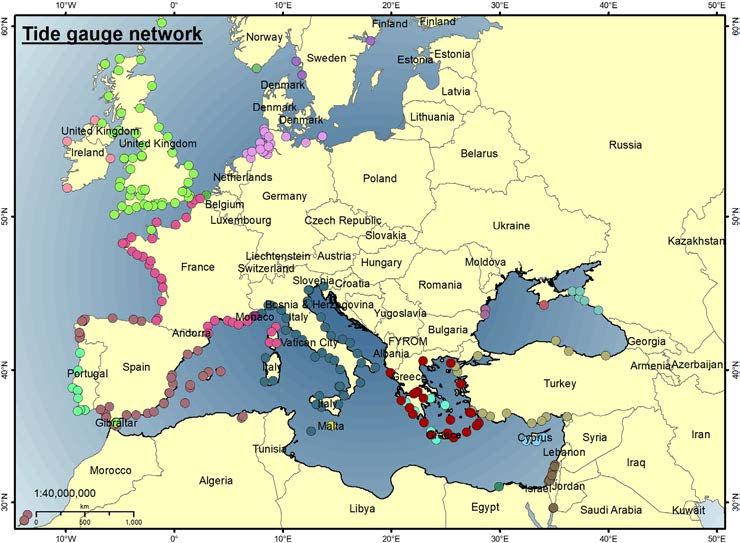
● Governing Bodies of the IOC
           Assembly: 150 Member States

           Executive Council: 40 Member States

    ● Terms of Reference
           Annex to Resolution XXIII-14:

               › To coordinate the activities of the ICG/NEAMTWS;
               › To organize and facilitate, as appropriate, the exchange of seismic, geodetic, sea level and other
                 data in or near real-time and information required for interoperability of the ICG/NEAM;
               › To promote the sharing of experience and expertise related to tsunami warning and mitigation for
                 the North-Eastern Atlantic, the Mediterranean and connected seas;
               › To promote tsunami research;
               › To promote the establishment and further development of national tsunami warning and mitigation
                 capacities in accordance with standard protocols and methods;
               › To develop, adopt and monitor implementation of work plans of the ICG/NEAMTWS, and to
                 identify required resources;
               › To promote implementation of relevant capacity-building;
               › To liaise and coordinate with other tsunami warning systems;
               › To liaise with other relevant organizations, programmes and projects;
               › To promote the implementation of the ICG/NEAMTWS within a multi-hazard framework;
               › To develop a comprehensive programme of capacity-building on tsunami protection for the North-
                 Eastern Atlantic, the Mediterranean and connected seas, including the Black Sea;
               › To keep under constant scrutiny the status of the system and how it satisfies the needs.

    ● Membership
           Fourty (40) Member States of the IOC bordering the North-Eastern Atlantic and those bordering and
           within the Mediterranean Sea and connected seas:
           Albania                       Finland                        Libya                         Romania
           Algeria                       France                         Malta                         Russian Federation
           Belgium                       Georgia                        Mauritania                    Slovenia
           Bulgaria                      Germany                        Monaco                        Spain
           Cabo Verde                    Greece                         Montenegro                    Sweden
           Croatia                       Iceland                        Morocco                       Syria
           Cyprus                        Ireland                        Netherlands                   Tunisia
           Denmark                       Israel                         Norway                        Turkey
           Egypt                         Italy                          Poland                        Ukraine
           Estonia                       Lebanon                        Portugal                      United Kingdom

           Observers from other IOC Member States.

           Invited observers from other organizations (including NGOs), programmes and projects, in accordance
           with the IOC rules and procedures.

6   Tsunami Early Warning and Mitigation System in the North-Eastern Atlantic, the Mediterranean and Connected Seas (NEAMTWS) 2005–2020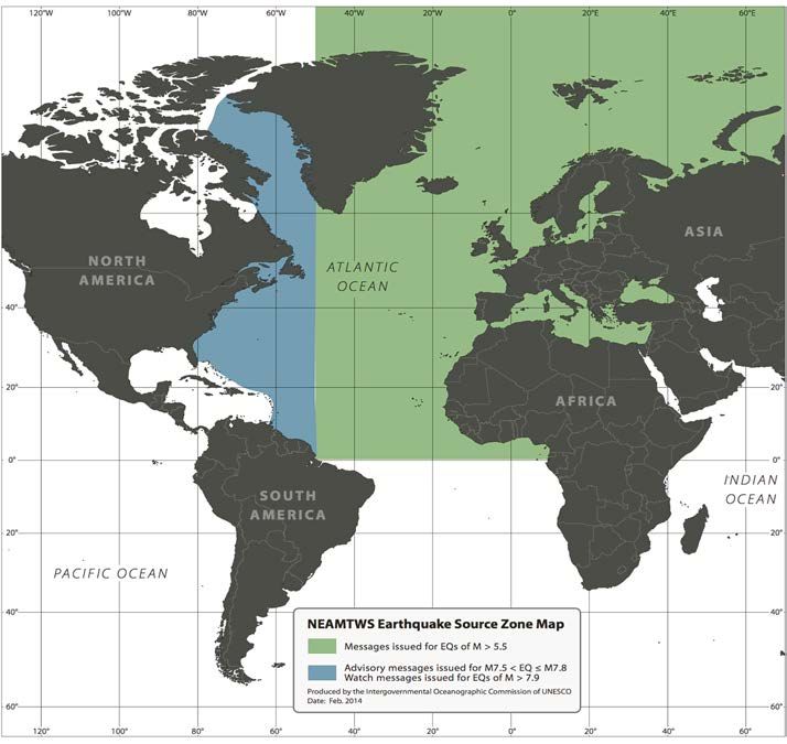
● Governance
            Officers composed of Chairperson and two Vice-Chairpersons. The Officers meet on the occasion of
            sessions of the ICG/NEAMTWS and also at meetings of the Steering Committee.

            The Steering Committee is composed of the Officers, the Co-Chairs of the Working Groups and Task
            Teams, and of one representative per Tsunami Service Provider (TSP).

            By IOC Rule of Procedure 48.3, the ICG/NEAMTWS reports to each ordinary session of the Assembly.

    ● Elected Officers (2017-2019)
            Chairperson:	Gerassimos Papadopoulos (Institute of Geodynamics,
                          National Observatory of Athens, Greece)
            Vice-Chairpersons:	Anna Von Glydenfeldt (Federal Maritime and Hydrographic Agency, Germany)
                                       Stefano Lorito (National Institute of Geophysics and Volcanology, Italy)

    ● Elected Officers (2020-2021)
            Chairperson:	Maria Ana Baptista (Higher Institute of Engineering of Lisbon, Polytechnic
                          Institute of Lisbon, Portugal).
            Vice-Chairperson:	Costas Synolakis (Division of Natural Sciences, Academy of Athens, Greece).

            Current Working Groups and Task Teams
            The Intergovernmental Coordination Group meets regularly to establish and implement working plans
            in the NEAM region. To address specific technical issues (terms of reference) it has formed four working
            groups and three task teams:

                › Working Group 1 – Hazard Assessment and Modelling – Co-chairs: Mauricio González (University of
                  Cantabria, Spain) and Audrey Gailler (Alternative Energies and Atomic Energy Commission. France)
                › Working Group 2 on Seismic and Geophysical Measurements and Working Group 3 on Sea
                  Level Data Collection and Exchange, Including Offshore Tsunami Detection and Instruments- Co-
                  chairs: Anna von Gyldenfeldt (Federal Maritime and Hydrographic Agency, Germany) and Didem
                  Cambaz (Bogazici University Kandilli Observatory and Earthquake Research Institute, Turkey)
                › Working Group 4 – Public Awareness, Preparedness and Mitigation – Co-Chairs: Areti Plessa
                  (Institute of Geodynamics, National Observatory of Athens) and Cecilia Valbonesi, (Department of
                  Legal Sciences, University of Florence, Italy)
                › Task Team on Tsunami Exercises – Co-Chairs: Ceren Özer Sözdinler (Kagawa University, Japan)
                  and Marinos Charalampakis (Institute of Geodynamics, National Observatory of Athens, Greece)
                › Task Team on Operations – Co-chairs: Alessio Piatanesi (National Institute of Geophysics and
                  Volcanology, Italy) and Fernando Carrilho (Portuguese Institute for Sea and Atmosphere, Portugal)
                › Task Team on Documentation – Co-Chairs: Brian McConnel (Geological Survey Ireland, Ireland)
                  and Alessandro Amato (National Institute of Geophysics and Volcanology, Italy)

Tsunami Early Warning and Mitigation System in the North-Eastern Atlantic, the Mediterranean and Connected Seas (NEAMTWS) 2005–2020   7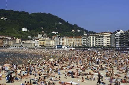
● ICG/NEAMTWS Sessions held
               › ICG/NEAMTWS-I                     Rome, Italy, 21–22 November 2005
               › ICG/NEAMTWS-II                    Nice, France, 22–24 May 2006
               › ICG/NEAMTWS-III                   Bonn, Germany, 7–9 February 2007
               › ICG/NEAMTWS-IV                    Lisbon, Portugal, 21–23 November 2007
               › ICG/NEAMTWS-V                     Athens, Greece, 3–5 November 2008
               › ICG/NEAMTWS-VI                    Istanbul, Turkey, 11–13 November 2009
               › ICG/NEAMTWS-VII                   Paris, France, 23–25 November 2010
               › ICG/NEAMTWS-VIII                  Santander, Spain, 22–24 November 2011
               › ICG/NEAMTWS-IX                    Southampton, United Kingdom, 10–13 September 2012
               › ICG/NEAMTWS-X                     Rome, Italy, 19–21 November 2013
               › ICG/NEAMTWS-XI                    Nicosia, Cyprus,11–14 November 2014
               › ICG/NEAMTWS-XII                   Dublin, Ireland, 16-18 November 2015
               › ICG/NEAMTWS-XIII                  Bucharest, Romania, 16-18 November 2016
               › ICG/NEAMTWS-XIV                   Lisbon, Portugal, 21-23 November 2017
               › ICG/NEAMTWS -XV                   Paris, France, 26-28 November 2018
               › ICG/NEAMTWS-XVI                   Cannes, France, 2-4 December 2019

    ● Secretariat focal point
           Mr Denis Chang Seng
           Programme Specialist
           Technical Secretary for the ICG/NEAMTWS
           Intergovernmental Oceanographic Commission of
           UNESCO
           7 Place de Fontenoy
           75352 Paris 07 SP, France
           Tel: +33 (0) 145 68 09 51
           Email: d.chang-seng@unesco.org

    ● Tsunami Service Providers (TSPs)
           Centre that monitors seismic and sea level activity and issues timely tsunami threat information within
           an ICG framework to National Tsunami Warning Centres/Tsunami Warning Focal Points and other TSPs
           operating within an ocean basin. The NTWCs/TWFPs may use these products to develop and issue
           tsunami warning for their countries. TSPs may also issue Public messages for an ocean basin and act
           as National Tsunami Warning Centres providing tsunami warnings for their own countries. Several ICG
           Tsunami Service Providers have been established in NEAM region.

           FRANCE: Centre d’Alerte aux Tsunamis (CENALT)
           GREECE: Institute of Geodynamics – National Observatory of Athens (NOA)
           ITALY: National Institute of Geophysics and Volcanology (INGV)
           PORTUGAL: Portuguese Institute for Sea and Atmosphere (IPMA)
           TURKEY: Kandilli Observatory and Earthquake Research Institute (KOERI)

8   Tsunami Early Warning and Mitigation System in the North-Eastern Atlantic, the Mediterranean and Connected Seas (NEAMTWS) 2005–2020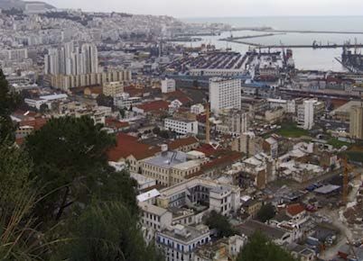
● National Tsunami Warning Centres (NTWCs)
            A centre officially designated by the government to monitor and issue tsunami warnings and other related
            statements within their country according to established national Standard Operating Procedures. NTWC
            in NEAM region includes the following countries:

            Denmark, France, Germany, Greece, Israel, Italy, Portugal, Romania, Spain, and Turkey.

    ● Earthquake Source Zone Monitored by the NEAMTWS-TSPs
            The map below shows the Area of Responsibility (AoR) of Tsunami Service Providers (TSPs) operating
            within the ICG/NEAMTWS.

Tsunami Early Warning and Mitigation System in the North-Eastern Atlantic, the Mediterranean and Connected Seas (NEAMTWS) 2005–2020   9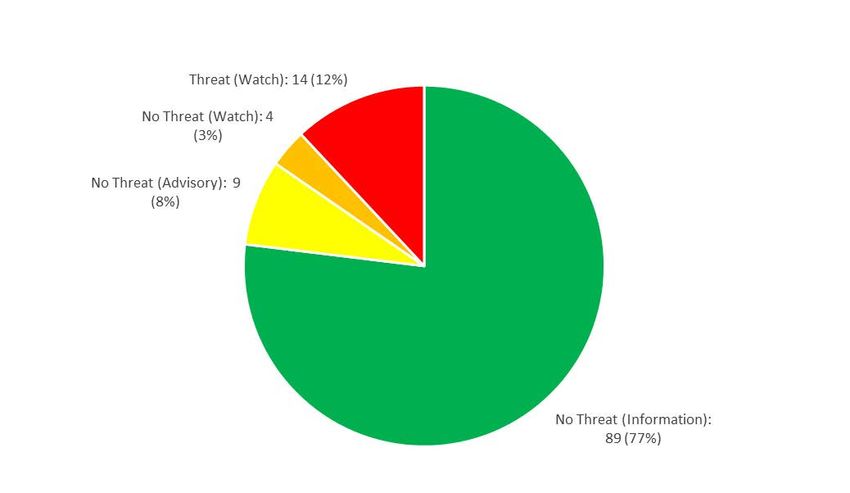
● NEAMTWS Core Seismic Network
            Figure below shows the core seismic network in NEAM region

               Source ICG-NEAMTWS 2019

     ● NEAMTWS Core Coastal Sea level Station Network

               Source ICG-NEAMTWS 2020

10   Tsunami Early Warning and Mitigation System in the North-Eastern Atlantic, the Mediterranean and Connected Seas (NEAMTWS) 2005–2020
● Historical tsunami catalogue
A unified catalogue is available providing information of 290 tsunamis generated in the European and
Mediterranean seas since 6150 BC to current days. The catalogue was developed based on the GITEC,
GITEC-II, and TRANSFER projects. The catalogue is the result of a systematic and detailed review of
all the regional catalogues available in literature covering the study area, each of them having their own
format and level of accuracy.
Euro-Mediterranean Tsunami Catalogue:
http://www.arcgis.com/apps/StorytellingTextLegend/index.html?appid=8329c2ad9b7f43c18562bdddc6c1ad26
Bibliography: Maramai A., Brizuela, B., Graziani L. 2014. The Euro-Mediterranean Tsunami Catalogue.
Annals of geophysics, Vol 57, No 4.
(http://www.annalsofgeophysics.eu/index.php/annals/article/view/6437)
Tsunami Early Warning and Mitigation System in the North-Eastern Atlantic, the Mediterranean and Connected Seas (NEAMTWS) 2005–2020 11● Tsunami Hazard Probability in NEAM Region
The TSUMAPS-NEAM project (http://www.tsumaps-neam.eu/, funded by the EU Humanitarian Aid
and Civil Protection) has developed the first homogeneous long-term Probabilistic Tsunami Hazard
Assessment (PTHA) for earthquake-induced tsunamis for the coastlines of the NEAM region. It is an
important step forward for the definition of good practices and guidelines for tsunami hazard.
Source TSUMAPS-NEAM project 2018
Further information is available at: http://www.tsumaps-neam.eu/
● Tsunami Exercises (NEAMWave)
Regional and national tsunami warning systems must maintain a high level of readiness, so that all the
actions relevant to public safety can be provided effectively and efficiently during fast-onset and rapidly-
evolving coastal disasters. The IOC of UNESCO and its Member States have advocated, through their
Intergovernmental Coordination Groups (ICGs), the regular conduct of tsunami exercises. To maintain
a high state of operational readiness, Tsunami Services Providers (TSPs) / National Tsunami Warning
Centres (NTWCs) and Civil Protection Agencies (CPAs) must regularly practice their emergency response
procedures to ensure that vital communication links work seamlessly, and that agencies and response
personnel know the roles they will need to play during a real event. Public education and awareness
are very important, particularly because of the very short time available for the warning to be acted upon.
The ICG/NEAMTWS has organised three regional tsunami exercises (NEAMWave 12, NEAMWave 14
and NEAMWave 17) in 2012, 2014 and 2017. The next NEAMWave exercise is expected to take place
in 2021.
Basili, R., Brizuela, B., Herrero, A., Iqbal, S., Lorito, S., Maesano, F. E., et al. (2018). NEAM Tsunami Hazard Model 2018 (NEAMTHM18):
online data of the Probabilistic Tsunami Hazard Model for the NEAM Region from the TSUMAPS-NEAM project. Istituto Nazionale di Geofisica
e Vulcanologia (INGV); Available at: http://doi.org/10.13127/tsunami/neamthm18.
Basili, R., Brizuela, B., Herrero, A., Iqbal, S., Lorito, S., Maesano, F. E., et al. (2019). NEAMTHM18 Documentation: the making of the
TSUMAPS-NEAM Tsunami Hazard Model 2018. doi:10.5281/ZENODO.3406625.
12 Tsunami Early Warning and Mitigation System in the North-Eastern Atlantic, the Mediterranean and Connected Seas (NEAMTWS) 2005–2020Participating
NEAMWAVE
Member States
NEAMWAVE 12, 27–28 November 2012 18
NEAMWAVE 14, 28–30 October 2014 20
NEAMWAVE 17, 30 October – 3 November 2017 20
● NEAMTIC
Tsunami warnings are of little use if people do not know how to react, and know what to do. In each of
the four regional Tsunami Systems – Tsunami Information Centres (TICs) have been established to support
Tsunami Warning Systems. NEAMTIC works in tandem with NEAMTWS.
NEAMTIC activities are aiming at:
› Making citizens aware of risks of floods from the sea in coastal areas, such as tsunamis, storm
surges and strong swells;
› Acquiring knowledge on and practicing safe behaviour;
› Identifing, sharing and disseminating good practices in plans, methods and procedures to
strengthen preparedness for sea-level related hazards, including mitigation through integrated
coastal zone management approaches;
› Educational and awareness raising materials can be downloaded from NEAMTIC website:
http://neamtic.ioc-unesco.org/
STRATEGIC GUIDANCE AND IMPLEMENTATION
The implimentation of NEAMTWS is supported by several key documents and projects.
● Guiding documents
› NEAMTWS Implementation Plan v. 3.4 (2009)
http://www.ioc-tsunami.org/index.php?option=com_content&view=article&id=69&Itemid=69&lang=en
› NEAMTWS Interim Operations Users Guide (2011)
http://www.ioc-unesco.org/index.php?option=com_oe&task=viewDocumentRecord&docID=4516
› NEAMTWS Development Plan (2011)
http://www.ioc-unesco.org/index.php?option=com_oe&task=viewDocumentRecord&docID=8110
› 10 years of the North-Eastern Atlantic, the Mediterranean and Connected Seas Tsunami
Warning and Mitigation System (NEAMTWS): accomplishments and challenges in preparing
for the next tsunami https://unesdoc.unesco.org/ark:/48223/pf0000247393
● Recent NEAMTWS Related Projects
› TSUMAPS-NEAM (Probabilistic Tsunami Hazard Maps for NEAM region, 2016-2017);
http://www.tsumaps-neam.eu/
› Tsunami Last Project for Greece (Kos)-Turkey (Bodrum), Joint Research Centre-European
Commission
Tsunami Early Warning and Mitigation System in the North-Eastern Atlantic, the Mediterranean and Connected Seas (NEAMTWS) 2005–2020 13● Summary of NEAMTWS-TSP Alert messages
issued from January 2013 to December 2019
The following graphs and tables provides a summary of the number of alert messages issued by TSPs
for the North-Eastern Atlantic, Western Mediterranean and Eastern Mediterranean) and the type of alert
messages (Information, Advisory, Watch) issued from January 2013 to December 2019.
Figure below shows the number of alert messages issued by region (TSP) from January 2013 to December 2019
118
84
38
28
21
14 14
3
NUMBER OF N-E ATLANTIC N-E ATLANTIC WESTERN MEDITERRANEAN EASTERN EASTERN TOTAL BULLETINS
EARTHQUAKE ISSUED BY IPMA ISSUED BY CENALT MEDITERRANEAN ISSUED BY CAT- MEDITERANNEAN MEDITERANNEAN ISSUED
EVENTS ISSUED BY CENALT INVG ISSUED BY NOA ISSUED BY KOERI
Figure below shows type of alert messages issued by TSPs from January 2013 to December 2019
NEAMTWS does not use THREAT Levels (yet). The Threat Levels indicated are its likely equivalent compared to other ICGs
14 Tsunami Early Warning and Mitigation System in the North-Eastern Atlantic, the Mediterranean and Connected Seas (NEAMTWS) 2005–2020Mediterranean Region
TSP (NOA, GREECE) TSP (KOERI, TURKEY) TSP (CENALT, France) TSP (INGV, ITALY)
GCMT Final Mag Mw
USGS Final Mag Mw
No. EQ Bulletins Issued
No. EQ. Threat Issued
No. Messages Issued
No. Messages Issued
No. Threat Bulletins
No. Threat Bulletin
No. Threat Bulletin
No. Threat Bulletin
(NOA mag Issued)
Time UTC &
(and final mag)
(and final Mag)
(and final Mag)
No.
Region
Date
Issued
Issued
Issued
Issued
14:18. 08 N. Aegean
1 5,7 1 (5.8) 1 (No Threat) 1 (6.2 ML) 1 (No Threat)
Jan. 2013 Sea, Limnos Isl.
21:17. 17
2 Egypt 4.9 (mb) 1 (5.5 Mw) 1 (No Threat)
Jan. 2013
03:12. 17
3 Ionian Sea 4.9 (mb) 1 (5.4 Mw) 1 (No Threat)
Feb. 2013
16:11. 15
4 Crete Isl. 6,2 1 (5.9) 1 (No Threat) 1 (6.0 Mw) 1 (No Threat)
Jun. 2013
21:39. 16
5 Crete Isl. 6.0 1 (5.7) 1 (No Threat) 1 (5.9 Mw) 1 (No Threat)
Jun. 2013
13:11. 12
6 W.Crete Isl. 6,6 1 (6.3) 1 (No Threat) 2 (6.4 Mw) 2 (Threat)
Oct. 2013
15:21. 28
7 Antalya Bay 5,9 1 (5.9) 1 (No Threat) 1 (6.1 Mw) 1 (No Threat)
Dec. 2013
18:45. 26 Ionian Sea, Out of Service
8 6,1 1 (5.9) 1 (No Threat)
Jan. 2014 Cephalonia Isl. Area
03:08. 03 Ionian Sea, Out of Service
9 6.0 1 (5.9) 1 (No Threat)
Feb. 2014 Cephalonia Isl. Area
20:08. 04 Aegean Sea,
10 5,6 1 (5.6) 1 (No Threat)
Apr. 2014 Hydra Isl.
09:25. 24 N. Aegean Sea,
11 6,9 1 (6.0) 1 (No Threat) 2 (6.6 Mw) 2 (Threat)
May. 2014 Samothraki Isl.
04:11. 01
12 North Algeria 5,6 1 (5.6) 1 (No Threat)
Aug. 2014
S. Aegean Sea,
03:45. 29
13 SE Pelopon- 5,8 1 (5.8) 1 (No Threat) 1 (5.6 Mw) 1 (No Threat)
Aug. 2014
nesus
08:25. 15 1 (No Threat)
14 Cyprus Region 5,3 1 (5.6)
Apr. 2015 Information
18:07. 16 2 (No Threat) 2 (No Threat)
15 Kasos Isl. 6.0 Mww 6.1 Mw 1 (6.1) 1 (6.2 Mw) 1 (No Threat) 2 (6.4 Mwp)
Apr. 2015 Watch Watch
02:05. 17 1 (No Threat)
16 Kasos Isl. 5,3 1 (5.6)
Apr. 2015 Information
07:10. 17 3 (Threat) Out of Service 4 (Threat)
17 Lefkas Isl. 6.5 Mww 6.5 Mw 1 (6.0) 4 (6.5 Mwp)
Nov. 2015 Watch Area Advisory
04:22. 25 2 (No Threat) Out of Service 3 (Threat)
18 Gibraltar 6.3 Mww 6.4 Mw 1 (6.2) 6,2 Advisory 3 (6.5 Mwp)
Jan. 2016 Watch Area Advisory
08:36. 25
19 Crete Isl. 5,3 1 (5.6) 2 (No Threat)
May. 2016
20:02. 28 Out of Service 0 (No Threat)
20 Tyrrhenian 5.8 Mww 5.8 Mw 5,7 Information 1 (5.7 mb)
Oct. 2016 Area Information
07:40. 30 2 (No Threat)
21 Norcia 6.6 Mww 6.6 Mw 2 (6.7 Mwp)
Oct. 2016 Watch
06:03. 20 Dodecanese 1 (No Threat)
22 5,4 1 (5.5)
Dec. 2016 Isl. Information
18:50. 25 2 (No Threat)
23 Crete Isl. 5,2 1 (5.5)
Jan. 2017 Advisory
12:28. 12 2 (No Threat) 2 (No Threat)
24 Lesvos Isl. 6.3 Mww 6.4 Mw 1 (6.2) 2 (6.3 Mw) 2 (Threat) 2 (6.5 Mwp)
Jun. 2017 Watch Advisory
22:31. 20 3 (Threat) 4 (Threat)
25 Bodrum-Kos 6.6 Mww 6.6 Mw 1 (6.4) 3 (6.6 Mw) 3 (Threat) 4 (6.8 Mwp)
Jul. 2017 Watch Watch
NEAMTWS does not use THREAT Levels (yet). The Threat Levels indicated are its likely equivalent compared to other ICGs
Tsunami Early Warning and Mitigation System in the North-Eastern Atlantic, the Mediterranean and Connected Seas (NEAMTWS) 2005–2020 15TSP (NOA, GREECE) TSP (KOERI, TURKEY) TSP (CENALT, France) TSP (INGV, ITALY)
GCMT Final Mag Mw
USGS Final Mag Mw
No. EQ Bulletins Issued
No. EQ. Threat Issued
No. Messages Issued
No. Messages Issued
No. Threat Bulletins
No. Threat Bulletin
No. Threat Bulletin
No. Threat Bulletin
(NOA mag Issued)
Time UTC &
(and final mag)
(and final Mag)
(and final Mag)
No.
Region
Date
Issued
Issued
Issued
Issued
22:54. 25 3 (Threat) Out of Service 6 (Threat)
26 Zakynthos Isl. 6,8 1 (6.4) 6 (6.8 Mwp)
Oct. 2018 Watch Area Watch
15:12. 30 2 (No Threat) Out of Service 0 (No Threat)
27 Zakynthos Isl. 5,7 1 (5.6) 1 (5.9 Mwp)
Oct. 2018 Advisory Area Information
02:26. 5
28 Albania 5.4 Mww 1 (5.6 Mw) Information
Feb. 2019
06:34. 20 W. Turkey / 1 (No Threat) 0 (No Threat)
29 5,7 1 (5.8) 1 (5.8 Mw) Information 1 (6.0 Mwp)
March. 2019 Rhodes Isl. Information Information
Greece-
04:26. 01
30 Albania Border 5.0 Mww 1 (5.5 Mw) Information
Jun. 2019
Region
11:13. 19
31 Greece 5.3 Mww 1 (5.5 Mw) Information
Jul. 2019
14:04. 21 1 (No Threat) 0 (No Threat)
32 Albania 5,6 1 (5.8) 1 (5.8 Mw) Information 1 (5.9 Mwp)
Sept. 2019 Information Information
10:59. 26 Marmara 0 (No Threat )
33 5.7 Mww 1 (5.7 Mw) Information 1 (5.9 Mwp)
Sept. 2019 Sea-Turkey Information
02:54. 26 2 (No Threat) Watch- 2 (No Threat)
34 Albania 6,4 1 (6.1) 2 (6.5 Mw) 1 (6.5 Mwp)
Nov. 2019 Advisory Cancellation Advisory
09:19. 26 Bosnia and 2 (No Threat)
35 5,4 1 (5.5)
Nov. 2019 Herzegovina Advisory
07:23. 27 2 (No threat) Advisory- o (No Threat)
36 Crete Isl. 6,0 1 (6.0) 3 (6.1 Mw) 1 (5.8 Mwp)
Nov. 2019 Watch Cancellation Information
21:58. 10 2 (No Threat)
37 Crete Isl. 5.4 Mww 1 (5.6) 1 (5.7 Mw) Information
Dec. 2019. Advisory
16 Tsunami Early Warning and Mitigation System in the North-Eastern Atlantic, the Mediterranean and Connected Seas (NEAMTWS) 2005–2020North-Eastern Atlantic Region
GCMT Final Mag Mw
USGS Final Mag Mw
Time UTC & Date
Region
TSP
No.
TSP (CENALT, France)
(IMPA, Portugal) Mw
No. Messages
No. Threat No. Messages Issued No. Threat Bulletin
Issued (and final
Bulletin Issued (and final Mag) Issued
Mag)
1 06:25. 30 Apr. 2013 Azores Islands 5,8 5,7 Information
2 22:04. 24 Jun. 2013 North Atlantic Ridge 6,5 6,7 Information
3 04:01. 05 Sept. 2013 Atlantic Ridge 6,0 5,9 Information
4 01:46. 30 Jun. 2014 Ascension 5,7 5,6 Information
5 01:28. 27 Jul. 2014 North Atlantic Ridge 6,1 5,5 Information
6 09:08. 07 Sept. 2014 Iceland 5,6 5,7 Information
7 10:22. 07 Oct. 2014 Iceland 5,5 5,6 Information
8 12:45. 19 Jan. 2015 Greenland Sea 5,4 5,5 Information
9 18:59. 13 Feb. 2015 North Atlantic Ridge 7,1 6,6 Information
10 18:03. 14 Aug. 2015 Northern Mid Atlantic Ridge 5,6 5,6 Information
11 15:59. 18 Sept. 2015 Northern Mid Atlantic Ridge 6,0 6,0 Information
12 02:41. 27 Feb. 2016 Central Mid-Atlantic Ridge 5,4 5,5 Information
13 10:32. 29 Mar. 2016 Svalbard Region 5,2 5,5 Information
14 16:26. 21 Jun. 2016 Northern Mid Atlantic Ridge 6,1 5,8 Information
15 05:49. 26 Jul. 2016 Central Mid-Atlantic Ridge 6,0 5,8 Information
16 04:29. 29 aug. 2016 North of Ascension Island 7,1 7,1 Information
17 17:17. 09 Sept. 2016 Northern Mid-Atlantic Ridge 5,3 5,6 Information
18 00:09. 20 Oct. 2016 Northern Mid-Atlantic Ridge 5,7 5,6 Information
19 01:34. 30 Jun. 2017 Northern Mid-Atlantic Ridge 5,6 5,6 Information
20 11:07. 01 Sept. 2017 Reykjanes Ridge 5,6 5,7 Information
21 21:40. 10 Sept. 2017 Reykjanes Ridge 5,8 5,6 Information
22 13:15. 28 nov. 2017 Norwegian Sea 5,6 5,6 Information
23 06:32. 30 Nov. 2017 Central Mid-Atlantic Ridge 6,5 6,3 Information
24 09:46. 11 Jan. 2018 Reykjanes Ridge 5,4 5,5 Information
25 03:29. 08 Feb. 2018 Greenland Sea 5,7 5,5 Information
26 09:27. 15 Feb. 2018 North of Ascension Island 5,6 5,5 Information
27 13:07. 18 Apr. 2018 South Atlantic Ocean 5,0 5,1 5,5 Information 5,7 Information
28 05:44. 23 May. 2018 Central Mid-Atlantic Ridge 5,7 5,5 Information
29 10:36. 23 Jul. 2018 Central Mid-Atlantic Ridge 5,9 6,0 5,6 Information 5,6 Information
30 07 Aug. 2018 Svalbard Region 5,7 Information
31 22 Aug. 2018 Near Coast of Venezuela 5,6 Information
32 28 Sept. 2018 Leeward Islands 5,8 Information
33 07 Oct. 2018 Central Mid-Atlantic Ridge 5,7 Information
34 16 Oct. 2018 Central Mid-Atlantic Ridge 5,5 Information
35 09 Nov. 2018 Jay Mayen Islands Region 6,8 Information
36 11 Nov. 2018 North Atlantic Ocean 6,2 Information
37 19:57. 14 Feb. 2019 Northern Mid-Atlantic Ridge 5,8 Information 5,7 Information
38 15:05. 25 Feb. 2019 Northern Mid-Atlantic Ridge 5,6 Information
39 17:58. 10 March. 2019 Reykjanes Ridge 5,5 Information
40 18:05. 10 March. 2019 Reykjanes Ridge 5,7 Information 5,7 Information
41 20:30. 17 Jun. 2019 Southern Mid-Atlantic Ridge 5,5 Information
42 00:40. 05 Aug. 2019 Southern Mid-Atlantic Ridge 5,8 Information
43 22:45. 02 Sept. 2019 Northern Mid-Atlantic Ridge 5,7 Information 5,8 Information
44 11:52. 05 sept. 2019 Northern Atlantic 5,6 Information
45 24 Sept. 2019 Mona Passage 6.0 Information
46 26 Sept. 2019 Canary Islands, Spain Region 5,8 Information
47 13:44. 13 Nov. 2019 Northern Mid-Atlantic Ridge 5,6 Information
Tsunami Early Warning and Mitigation System in the North-Eastern Atlantic, the Mediterranean and Connected Seas (NEAMTWS) 2005–2020 17United Nations Intergovernmental
Educational, Scientific and Oceanographic
Cultural Organization Commission
7, place de Fontenoy 75352 Paris 07 SP France
Tel: + 33 1 45 68 39 84
www.ioc.unesco.org
www.ioc-tsunami.org
IOC Brochure 2020-3 (IOC/BRO/2020/3)You can also read