UCD Students' Strategic Vision - Draft for Consultation March 2019 - UCD Students' Strategic Vision
←
→
Page content transcription
If your browser does not render page correctly, please read the page content below
3/12/2019                                       Appendix 2: Transport Options Assessment - Google Docs

                         UCD Students’
                         Strategic Vision

                               Draft for Consultation
                                    March 2019

                                                 Appendix 2:
                      Transport Options Assessment

                                    Prepared by
                     UCD Planning & Environmental Policy Society

                                                                                                         1

https://docs.google.com/document/d/1Eogi47gQfgcnWEnzKDbaQIX7nEnCk-9ksGwZsuXnQfI/edit#                        1/44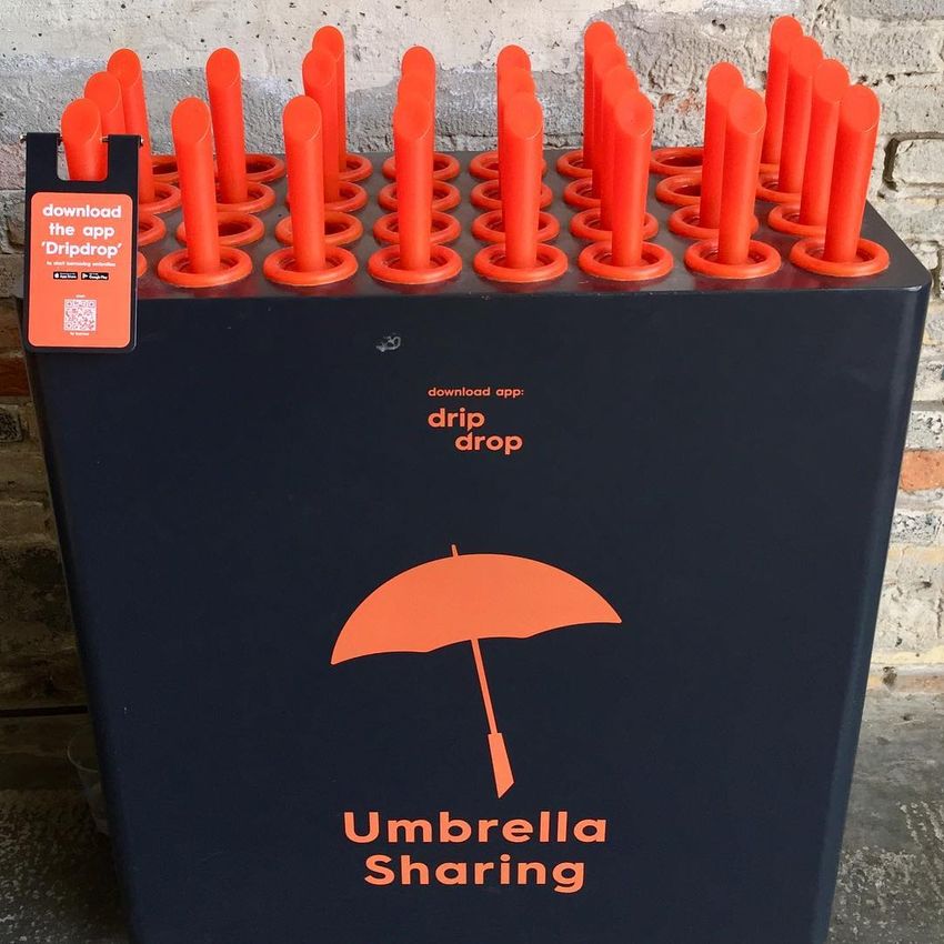
3/12/2019                                       Appendix 2: Transport Options Assessment - Google Docs

            Table of Contents

            1. Introduction                                                                               4

            2. Smarter Travel                                                                             5
               2.1 Mode Share and Reasons for Driving                                                     5
               2.2 Environmental Impact                                                                   5
               2.3 Encouraging a switch to sustainable modes                                              6
               2.4 Recommendations                                                                        6

            3. Walking                                                                                   7
               3.1 Introduction                                                                           7
               3.2 Wayfinding                                                                             8
               3.3 Shelter and Security                                                                   9
               3.4 Other Issues Identified                                                               11
               3.5 Recommendations                                                                       11

            4. Cycling                                                                                   12
               4.1 Introduction                                                                          12
               4.2 Greater Dublin Area Cycle Network Plan                                                14
               4.3 Cycling into and within the Campus                                                    15
               4.4 Bicycle Parking and Facilities                                                        16
               4.5 Bicycle Sharing                                                                       17
               4.6 Recommendations                                                                       18

            5. Bus Services                                                                              19
               5.1 Introduction                                                                          19
               5.2 BusConnects                                                                           19
               5.3 Dublin Area Bus Network Redesign - Overall Assessment                                 22
                   5.3.1 Structure of Network                                                            22
                   5.3.2 Requirement to Interchange More Often                                           22
                   5.3.3 Ease of Use and Mobility Impairments                                            23
                   5.3.4 Proposed Fare Changes                                                           23
               5.4 Dublin Area Bus Network Redesign - Changes for UCD                                    24
                   5.4.1 Replacement of 39a with New B Spine                                             24
                   5.4.2 Replacement of 46a & 145 with New E Spine                                       25
                   5.4.3 Replacement of 17 with New Orbital Routes S4 and S6/S7                          26
                   5.4.4 Replacement of 11 with New Route 10                                             27
                   5.4.5 Replacement of 47 with New Route 213                                            27
                   5.4.6 Peak-Only Non-Express Routes                                                    28
                   5.4.7 Peak-Only Express Routes                                                        28
               5.5 Bus Stops and Interchange                                                             30

                                                                                                         2

https://docs.google.com/document/d/1Eogi47gQfgcnWEnzKDbaQIX7nEnCk-9ksGwZsuXnQfI/edit#                         2/44
3/12/2019                                       Appendix 2: Transport Options Assessment - Google Docs

               5.6 Richview and Newstead                                                                 30
               5.7 Operating Hours                                                                       31
               5.8 Evening and Late Night Services                                                       32
               5.9 Information on Bus Services                                                           32
               5.10 Recommendations                                                                      33

            6. Rail Services                                                                             34
               6.1 Introduction                                                                          34
               6.2 MetroLink Extension to UCD                                                            34
               6.3 Luas to DART Connector                                                                36
               6.4 BlueLine Bus Rapid Transit                                                            37
               6.5 Urban Cable Car                                                                       37
               6.6 Enhanced Connections with Rail Services                                               38
               6.7 Recommendations                                                                       39

            7. Private Vehicles                                                                          40
               7.1 Car Parking Management                                                                40
               7.2 Park and Ride                                                                         40
               7.3 Carpooling                                                                            41
               7.4 Car Clubs                                                                             41
               7.5 Recommendations                                                                       42

            8. Addressing Congestion                                                                     43
               8.1 Impact of Congestion on Journey Times                                                 43
               8.2 Dublin Eastern Bypass Public Transport Corridor                                       44
               8.3 Recommendations                                                                       44

                                                                                                         3

https://docs.google.com/document/d/1Eogi47gQfgcnWEnzKDbaQIX7nEnCk-9ksGwZsuXnQfI/edit#                         3/44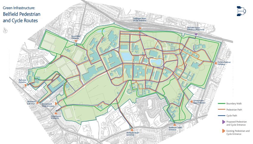
3/12/2019                                       Appendix 2: Transport Options Assessment - Google Docs

            1. Introduction
            Transport and access to the campus was one of the most frequently raised topics throughout
            the consultation process, with many responses highlighting the difficulty in accessing the
            campus and long commuting journeys for students and staff. Transport is also one of the
            largest environmental challenges facing the university, with 3,000 vehicles driving to the
            campus each morning, making UCD one of the largest generators of transport emissions
            and traffic congestion in the Greater Dublin Area.

            While there is general consensus that walking, cycling and public transport should be
            favoured, there are many issues which need to be addressed. Many respondents felt that
            conditions for walking and cycling need to be improved and made safer, while public
            transport connections need to be quicker and more direct, and avoid the inconvenience of
            travelling via the city centre for many journeys.

            Responses relating to car access and parking were quite mixed. Some called for additional
            parking to be constructed, while many others argued that UCD needs to stop being so
            amenable to car drivers, and should increase the ridiculously low cost of parking permits to
            discourage driving to the campus. Others called for a reduction in parking, but for it to be
            prioritised for those who genuinely need it, and not free for all as it currently is.

            The Vision aims for a campus which is easy to access by all modes of transport, is a leader
            in sustainable commuting, and is not a significant generator of traffic congestion or transport
            emissions. To reach this Vision, it is proposed to take an approach of improving access to
            the campus by walking, cycling and public transport, to provide people with an attractive
            alternative to driving, while also taking measures to discourage driving.

            Walking and cycling, as the most environmentally friendly modes, should be promoted and
            encouraged where possible. Due to UCD’s extensive catchment area, these modes are not
            suitable for everyone, and public transport will continue to be the primary mode of
            commuting to the campus. Private vehicles also need to be facilitated, but should be
            discouraged for those who can easily use another mode.

                                                                                                           4

https://docs.google.com/document/d/1Eogi47gQfgcnWEnzKDbaQIX7nEnCk-9ksGwZsuXnQfI/edit#                          4/44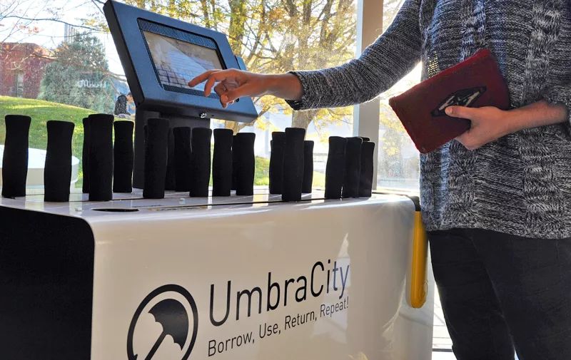
3/12/2019                                       Appendix 2: Transport Options Assessment - Google Docs

            2. Smarter Travel

            2.1 Mode Share and Reasons for Driving
            Commuting mode shares for car drivers vary significantly between students and staff, with
            19% of students driving by car and 42% of staff driving by car. The highest proportion of
            students drive from areas along the southern part of the M50, while the highest proportion of
            staff drive from areas along the M50, the Stillorgan Road and Bray Road south of UCD,
            areas to the west of the campus around Rathfarnham, and the southeast coast from Dún
            Laoghaire to Greystones.

            The significant difference in mode shares between students and staff can be partly explained
            by the closer concentration of students to the campus, such as in on-campus residences and
            rented accommodation. However, the high proportion of staff driving from areas with good
            public transport to the campus, such as along the Stillorgan Road, indicates that a large
            proportion of staff are driving because of convenience, and could easily be making their
            journey by more sustainable modes of travel.

            This assumption is supported by the reasons stated by students and staff for their mode
            choice. While 16% and 32% of students cited Cheapest or No alternative as their reason for
            mode choice respectively, only 7% and 18% of staff did respectively. Over twice as many
            staff than students cited Flexibility as their reason for mode choice, at 20% and 9%
            respectively. Staff were also significantly more of initiatives such as the DART Shuttle Bus
            (88%) and GoCar Scheme (60%) than students were (59% and 25% respectively).

            Despite a closer concentration of students to the campus, of those who drive to the campus,
            students tend to have a longer distance and journey time in comparison to staff. Interestingly,
            44% of students regularly have difficulty in finding a car parking space on campus, which is
            triple the proportion of staff who regularly have difficulty, at 14%. The reasons for this are
            unclear. However, what is clear is that current commuting mode shares for staff are
            significantly less sustainable than they are for students.

            2.2 Environmental Impact
            With over 3,000 cars coming onto the campus every morning, and approximately 14,000
            vehicle movements in and out of the campus every day, UCD is one of the largest
            generators of private vehicle demand and traffic congestion in the Greater Dublin Area. This
            is one of the largest environmental challenges facing the university, and the university
            community should seek to significantly reduce the use of private vehicles in favour of more
            sustainable travel modes over the coming years.

                                                                                                         5

https://docs.google.com/document/d/1Eogi47gQfgcnWEnzKDbaQIX7nEnCk-9ksGwZsuXnQfI/edit#                         5/44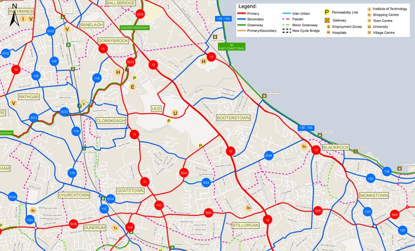
3/12/2019                                       Appendix 2: Transport Options Assessment - Google Docs

            2.3 Encouraging a switch to sustainable modes
            All students and staff seeking an annual parking permit should be required to provide a
            justification of why they need to drive to UCD on a regular basis, and why more sustainable
            options are not suitable for them. The purpose of this is not to prevent anyone from obtaining
            a permit, but to encourage them to think about what other options are available to them, and
            to help us understand why people are driving.

            Any permit holders who decide to switch to a more sustainable mode of transport should be
            entitled to a refund on the proportion of the permit remaining, and should not be locked into
            driving because they have already spent money on this.

            2.4 Recommendations
            The following measures should be included in the Vision:

               ●   A measure to consider possible incentives to encourage and promote sustainable
                   commuting.
               ●   A measure to better manage parking to facilitate car access for those who require it,
                   while discouraging driving for those who could easily use a more sustainable mode.

            While these measures do not specifically address all issues identified, they provide a wide
            enough scope to allow for additional related issues to also be considered and addressed.

                                                                                                            6

https://docs.google.com/document/d/1Eogi47gQfgcnWEnzKDbaQIX7nEnCk-9ksGwZsuXnQfI/edit#                           6/44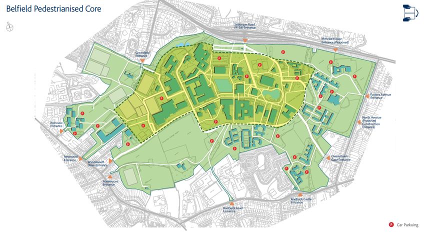
3/12/2019                                       Appendix 2: Transport Options Assessment - Google Docs

            3. Walking

            3.1 Introduction
            Walking is the primary form of travel within the UCD Campus, catering for nearly all internal
            movement between buildings, recreational facilities, public transport stops and car parks. It is
            also the main mode of commuting for 13% of students and 8% of staff, and a secondary
            mode of commuting for 20% of students and 16% of staff (Commuting Survey 2017-18). The
            7% of students living in on-campus accommodation account for a large portion of those who
            commute by foot, and this is expected to rise over the coming years in line with the
            construction of the new Student Residences Masterplan.

            In recent years, successive campus development plans have significantly improved
            pedestrian conditions and experience. The central core of the campus has been fully
            pedestrianised, with all vehicular traffic and parking moved to the edges of the campus,
            along the campus ring road. In addition to this, a network of recreational woodland walks
            have been developed around the boundary of the campus, which are widely used by the
            local residential community, in addition to students and staff.

            Figure 1: Belfield Pedestrianised Core, with vehicular traffic and parking moved to the edges
            (source: UCD Strategic Campus Development Plan 2026-2021-2026)

            While significant improvements have been made, there are still many challenges which
            remain. Due to the large size of the campus, many journeys within the campus can be over a
            kilometre in length, which is not ideal, particularly during inclement weather conditions or
            dark hours. The lack of clear and updated signage can also make it difficult for people to

                                                                                                          7

https://docs.google.com/document/d/1Eogi47gQfgcnWEnzKDbaQIX7nEnCk-9ksGwZsuXnQfI/edit#                          7/44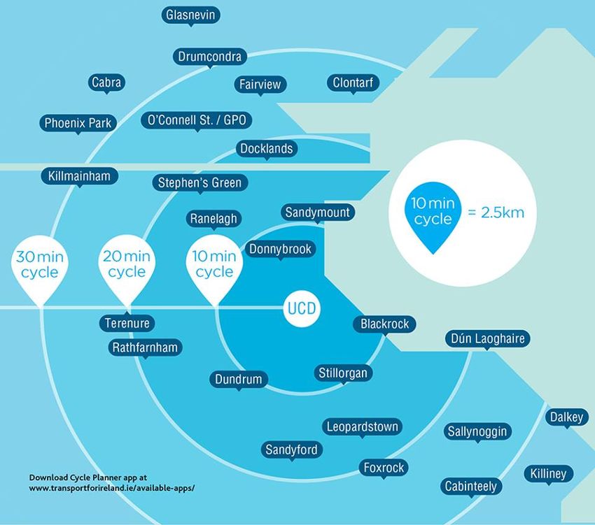
3/12/2019                                       Appendix 2: Transport Options Assessment - Google Docs

            orientate themselves and find their way around the campus. Movement for those with a
            mobility impairment is also a significant issue, due to long distances and the frequency of
            steps in older parts of the campus, which create a difficult and unfriendly environment.

            3.2 Wayfinding
            Due to the large size of the UCD campus and the extensive number of buildings it can be
            difficult to find your way around the campus. As of January 2019, there are over 150
            buildings on the Belfield Campus, consisting of 82 residential buildings and around 70
            academic, research or other buildings. Adding to this confusion, there are also several
            buildings which have multiple names, such as the O’Brien Centre for Science, which is also
            known by its individual blocks such as Science East or Science Hub, or the John Hume
            Building, which is also known as the Global Irish Institute, as well as the William Jefferson
            Clinton Auditorium.

            Currently, signage within the campus is limited, and consists only of large signs in a number
            of locations, displaying maps of the campus. Many of these maps are over 10 years out of
            date, still displaying buildings which no longer exist, such as the Thornfield horticultural
            facility, and are missing newer items on the campus such as the Upper Lake. Many of the
            maps also lack a “You are here” marker to indicate to people where on the map they
            currently are, which makes it difficult for people to orientate themselves.

            Figure 2: Example of faded wayfinding map, ten years out of date and lacking a “You are
            here” marker (source: Google Street View)

            In recent years, UCD Estate Services have developed a very comprehensive online map of
            the campus, which is available at http://map.ucdestates.ie/ and on the UCD Mobile App. This

                                                                                                            8

https://docs.google.com/document/d/1Eogi47gQfgcnWEnzKDbaQIX7nEnCk-9ksGwZsuXnQfI/edit#                           8/44
3/12/2019                                       Appendix 2: Transport Options Assessment - Google Docs

            map allows users to search for various different services and facilities, including buildings,
            restaurants, shops, transport and natural features, among others. As of January 2019 the
            map currently contains 637 individual services. While the map is not particularly well known,
            the addition of it into the new UCD Mobile App in 2018 has helped to boost its presence.

            Figure 3: Online UCD Services Map (can be filtered by service or facility type)

            In the short term, current out of date maps and signage across the campus should be
            updated to prevent them from causing any confusion, while the online UCD Services Map
            should be promoted as the easiest method for finding locations and services. In the medium
            term, a wayfinding strategy should be prepared for the campus, to identify the most
            appropriate ways for directing people around the campus. This could simply involve
            providing more direction signs, or could take a more innovative approach, such as the
            painted lines which have been used for many years within the Newman Building.

            3.3 Shelter and Security
            Due to the large size of the campus, and the distances between some locations, shelter and
            security are important issues which need to be considered. While covered walkways connect
            some of the main buildings within the centre of the campus, any walks beyond this such as
            to the main gates of the campus or to public transport stops involve crossing areas of
            parkland or car parks, which are unsheltered from the weather and can be dark and lonely
            during the evening and night.

            For example, a walk from the Newman Building, James Joyce Library or O’Brien Centre for
            Science to the Stillorgan Road bus stops is over 600 metres in length, with no shelter. A
            larger example is a walk from a more remote area of the campus, such as the Richview
            School of Architecture, to the campus bus park or student residences, which is over 1.5
            kilometres in length, with only around 400 metres of this under covered walkways.

                                                                                                         9

https://docs.google.com/document/d/1Eogi47gQfgcnWEnzKDbaQIX7nEnCk-9ksGwZsuXnQfI/edit#                        9/44
3/12/2019                                       Appendix 2: Transport Options Assessment - Google Docs

            The construction of covered walkways between all parts of the campus would be very costly,
            and probably very unsightly, so would not be a viable option. However, there are other
            measures which could also be considered to provide shelter. For example, recently, a
            number of Umbrella Sharing Schemes have begun to emerge in various location around the
            world, such as UmbraCity in Vancouver, Dripdrop in Aarhus and Nestia in Singapore.

            These schemes follow the same principle as bike sharing schemes, by allowing people to
            take an umbrella when they need one and drop it back when they are finished using it. Due
            to the relatively low costs required to implement such a system, it could be a cost effective
            way of providing some form of rain shelter to all parts of the campus, particularly for journeys
            to more remote locations such as Richview, Roebuck or Nova.

            Figure 4: Examples of Umbrella Sharing Schemes in Vancouver and Aarhus

            To improve the sense of security along main pedestrian routes, the most important aspects
            to focus on are on increasing lighting, security presence and CCTV, particularly at locations
            requested by students and staff. UCD Unicare encourages people to walk in groups during
            dark hours, and provides a Walk Safe service, where members of the UCD Community can
            request to be accompanied when walking within the campus during dark hours, although it is
            not widely used.

            In the medium to long term, more permanent solutions should be implemented to improve
            shelter and security on the campus. The Entrance Precinct Masterplan will provide an
            opportunity to significantly improve pedestrian connections from the centre of the campus to
            the main Stillorgan Road entrance and public transport stops. A strategy should be prepared
            to identify the most appropriate ways of providing shelter and security for pedestrian
            movement into the future, which can be incorporated into future developments.

                                                                                                         10

https://docs.google.com/document/d/1Eogi47gQfgcnWEnzKDbaQIX7nEnCk-9ksGwZsuXnQfI/edit#                          10/44
3/12/2019 Appendix 2: Transport Options Assessment - Google Docs
3.4 Other Issues Identified
Other issues identified during the consultation process include:
● The gates between the Sports Centre and Hockey Stadium, frequently used by
people walking to/from Richview and Newstead, are unreliable and only open
sporadically, often forcing students to make a 100m detour around the Hockey
Stadium. This issue could be addressed by having the gates open at more times, and
by advertising specific opening hours so students know when it is available.
● The staircases in the Science Hub can become congested and dangerous at times,
although with four staircases, this should be sufficient. This issue could be addressed
through better signage and awareness of traffic routing.
● The type of stone used around the James Joyce library becomes very slippery when
wet.
● The junction between the James Joyce Library, Agriculture Science and O’Brien
Centre for Science is a black spot for collisions between pedestrians and cyclists,
due to the blind spot created by the graffiti wall on the corner. This issue could be
addressed through increasing visibility or by providing cautionary markings.
● The UCD Walk Safe service is not widely used, possibly because people may feel
embarrassed to call and request it. To encourage more use, other options could be
explored to avoid the need to request it, such as by having designated departure
points or times at likely locations such as the James Joyce Library or Student Centre.
3.5 Recommendations
The following measures should be included in the Vision:
● A measure to prepare and implement a wayfinding strategy for the campus.
● A measure to create an umbrella sharing scheme between buildings on the campus.
● A measure to remove all barriers and obstacles to internal movement within the
campus, particularly for pedestrians, cyclists and those with mobility impairments.
While these measures do not specifically address all issues identified, they provide a wide
enough scope to allow for additional related issues to also be considered and addressed.
11
https://docs.google.com/document/d/1Eogi47gQfgcnWEnzKDbaQIX7nEnCk-9ksGwZsuXnQfI/edit# 11/443/12/2019 Appendix 2: Transport Options Assessment - Google Docs
4. Cycling
4.1 Introduction
Cycling is the main mode of commuting for 19% of students and 24% of staff, and is a
secondary mode of commuting for 2% of both students and staff. The majority of those who
cycle commute for journeys of 30 minutes or less (86% of students and 71% of staff) and for
distances of 10 kilometres or less (91% of students and 83% of staff). With over 7,000 cycle
journeys to or from the campus on an average weekday, UCD is the largest cycle destination
in Ireland.
Figure 5 below shows the areas within cycling distance of UCD, while Figure 6 shows
predicted cycling demand for the AM peak period in the vicinity of the campus in 2021.
Figure 7 shows current cycling infrastructure in the vicinity of the campus. Cycle facilities are
provided along most main routes, including the Clonskeagh Road, Stillorgan Road, Merrion
Road/Rock Road and Mount Merrion Avenue. However, the quality of these facilities varies
significantly, from segregated cycle tracks along some sections to only advisory cycle lanes,
even within bus or car lanes, along other sections.
Figure 5: Map of Cycling Distances to UCD
12
https://docs.google.com/document/d/1Eogi47gQfgcnWEnzKDbaQIX7nEnCk-9ksGwZsuXnQfI/edit# 12/443/12/2019 Appendix 2: Transport Options Assessment - Google Docs
Figure 6: Predicted AM Peak Cycling Demand 2021 (source: GDA Cycle Network Plan)
Figure 7: Existing Cycle Facilities in the vicinity of UCD (source: GDA Cycle Network Plan)
13
https://docs.google.com/document/d/1Eogi47gQfgcnWEnzKDbaQIX7nEnCk-9ksGwZsuXnQfI/edit# 13/443/12/2019 Appendix 2: Transport Options Assessment - Google Docs
The main focus for cycling in the near future should be on improving the quality and safety of
facilities, so that cyclists of all ability and confidence can commute to UCD comfortably and
without having to mix with other traffic.
4.2 Greater Dublin Area Cycle Network Plan
The Greater Dublin Area Cycle Network Plan, published by the National Transport Authority
in 2013, sets out a plan for a comprehensive cycle network across the Greater Dublin Area.
It identifies the primary, secondary and feeder network within the urban area of the city and
towns, as well as an interurban cycle network and green route network. This cycle network
plan forms the basis for future investment in cycle infrastructure, and is being progressed
through individual projects and schemes.
Figure 8 below shows the proposed cycle network in the vicinity of UCD. The plan proposes
6 primary routes (shown in red) in the vicinity of UCD:
● Route 11 - City Centre to Dundrum/Sandyford, along the Clonskeagh Road
● Route 12 - City Centre to Bray, along the Stillorgan Road
● Route 13 - City Centre to Blackrock, along the Merrion Road/Rock Road
● Route SO3 - Dodder Greenway from Grand Canal Dock along the River Dodder to
Templeogue, and extending to Tallaght (as Route 9A)
● Route SO4 - UCD to Dundrum, and extending to Ballinteer (as Route 11D)
● Route SO5 - Dún Laoghaire via Stillorgan, Dundrum and Knocklyon to Tallaght
Figure 8: Proposed GDA Cycle Network Plan in the vicinity of UCD
14
https://docs.google.com/document/d/1Eogi47gQfgcnWEnzKDbaQIX7nEnCk-9ksGwZsuXnQfI/edit# 14/443/12/2019 Appendix 2: Transport Options Assessment - Google Docs
There are also primary links within the UCD Campus, connecting the Stillorgan Road,
Greenfield Park and Wynnsward Drive entrances. An additional network of secondary routes
(shown in blue) and feeder routes (dashed purple) also covers many other routes within the
vicinity of the campus.
Route 11 is to be delivered under two schemes, the Sandyford to Clonskeagh Cycle Scheme
and the Clonskeagh to City Centre Cycle Scheme. Routes 12 and 13 are to be upgraded as
part of the BusConnects Core Bus Corridor Project, with detailed designs published in late
February 2019. A public consultation on the emerging preferred route for the Dodder
Greenway between Grand Canal Dock and Orwell Park took place during 2018, while no
schemes have yet been brought forward in relation to Routes SO4 and SO5.
The detailed design of each route will be decided at the project stage, but all routes are
targeted to have a high quality of service with few interruptions, a high level of comfort and
low junction time delays. While little progress has been made under this plan to date, it
provides a huge opportunity to improve the quality of cycle routes to UCD, and across the
wider city, and it is important that it’s implementation is strongly supported by students.
4.3 Cycling into and within the Campus
Figure 9: Belfield Cycle and Pedestrian Routes (source: UCD Strategic Campus
Development Plan 2026-2021-2026)
Figure 9 shows the various entrances into the campus, along with the main internal cycle
and pedestrian routes. The majority of pedestrians and cyclists enter the campus through the
Wynnsward Drive entrance (35% of students and 31% of staff) or the Stillorgan Road
entrance (33% of students and 30% of staff). As these are also the busiest entrances for
15
https://docs.google.com/document/d/1Eogi47gQfgcnWEnzKDbaQIX7nEnCk-9ksGwZsuXnQfI/edit# 15/443/12/2019 Appendix 2: Transport Options Assessment - Google Docs
vehicular traffic, there can be movement conflicts between cyclists and vehicles entering and
exiting the campus at these locations, which can be dangerous.
At the Wynnsward Drive entrance, cyclists coming from the south have to weave across two
lanes of traffic to get from the cycle lane on the left to the right turn lane for the campus.
During 2017, Dún Laoghaire-Rathdown County Council held a public consultation on a
proposed scheme to address this, by providing a jug handle turn on the left and a dedicated
cycle light for turning right into the campus. This will allow cyclists to stay in the cycle lane on
the left and wait for a dedicated green light to cross the road.
At the Stillorgan Road entrance, the majority of cyclists entering the campus continue
straight ahead into the centre of the campus, while the majority of cars are turning left to
access car parks, across the path of cyclists. Planning permission was granted during 2018
for a new cyclist and pedestrian entrance to the campus from the Stillorgan Road at Nova
UCD. This will provide cyclists with a safer and more convenient entrance to the campus,
and will remove the need for many cyclists to use the main Stillorgan Road entrance.
An issue frequently raised during the preparation of this Vision was the difficulty of cycling
through parts of the campus, due to high numbers of pedestrians and many obstacles such
as steps. Some responses highlighted the importance of wheelchair ramps for cycle
movement through the campus, but that many ramps were not designed to facilitate this.
Other responses called for dedicated cycle lanes through the busiest parts of the campus, to
separate pedestrians from cyclists.
While dedicated cycle lanes would make it easier for cyclists to move through the campus,
they would also encourage higher cycling speeds, which could pose a serious risk to any
pedestrians who inadvertently stray into the cycle lane. Dedicated cycle lanes are generally
not suitable for areas with high numbers of pedestrians, but should be considered in other
areas. Other measures such as providing cycle lanes and parking at the rear of buildings
could also be considered, to allow cyclists to avoid the busiest pedestrian areas.
4.4 Bicycle Parking and Facilities
There are over 4,500 cycle parking spaces across the UCD campus, ranging from older
wheel racks to more modern sheffield stands, as well as bicycle lockers and a secure
card-accessed parking area. While the university has been steadily increasing the number of
bicycle spaces in recent years, there are still a number of locations where many bicycles are
locked to trees or railings, and where additional parking should be provided.
Shower and locker facilities are provided for cyclists in a number of buildings throughout the
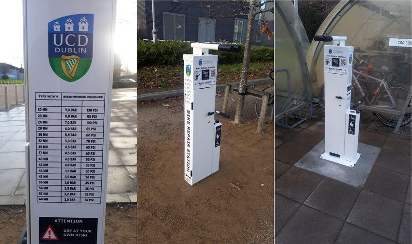
campus, although these are not particularly well promoted. In December 2018 UCD Estate
Services also installed new self-fix bicycle repair stations at 3 locations in the campus, with a
further 5 to be installed in 2019. These stations have integrated tools and pump, with a list of
recommended pressures. Current facilities should be promoted better to students, and other
facilities should be provided where there is a demand to have them.
16
https://docs.google.com/document/d/1Eogi47gQfgcnWEnzKDbaQIX7nEnCk-9ksGwZsuXnQfI/edit# 16/443/12/2019 Appendix 2: Transport Options Assessment - Google Docs
Figure 10: New Self-fix Bicycle Repair Stations (source: UCD Estate Services)
The Belfield Bike Shop, located on-campus, also provides a range of services, including
bicycle sales and rental, a bicycle repair service, and coaching. The shop provides bicycles
under the Government’s Cycle to Work Scheme, as well as under their own Buy Back
Scheme, where they will buy back bicycles they have sold for up to 50% of their purchase
price.
4.5 Bicycle Sharing
In 2017, Bleeperbike launched Ireland’s first stationless bike share scheme on the UCD
campus. This has since been extended to cover a large part of the city, stretching from DCU
and Raheny in the north to Rathfarnham and Dún Laoghaire in the south. While there are no
stations, users can use a smartphone app to locate nearby bicycles, and when finished must
park their bike at designated bike racks which are also marked on the app. There are 8 such
designated racks within the UCD campus, shown in Figure 4 below.
While these stations may be sufficient for longer journeys to or from the campus, the limited
number of stations limits the usefulness of the scheme for short journeys starting and ending
within the campus. For example, these stations make it inconvenient to use for journeys
such as from Newstead to the Stillorgan Road Bus Stops, or from student residences to the
Veterinary Sciences Centre or Conway Institute. The scheme could benefit from the addition
of more designated racks across the campus.
17
https://docs.google.com/document/d/1Eogi47gQfgcnWEnzKDbaQIX7nEnCk-9ksGwZsuXnQfI/edit# 17/443/12/2019 Appendix 2: Transport Options Assessment - Google Docs
Figure 11: Bleeperbike Designated Parking Racks across the UCD Campus
The very successful public DublinBikes Scheme currently only operates within the city
centre, and does not extend out to UCD. A major expansion plan, proposed in 2010 and
originally proposed to be completed by 2016, would have seen the scheme significantly
expand across 14 phases, including areas such as Donnybrook and Clonskeagh. However,
due to a lack of funding, only the first two of these phases were ever completed, and there is
no clear timescale for the remainder of the expansion phases.
Even with the availability of alternative stationless bicycle sharing schemes such as
Bleeperbike, the DublinBikes scheme has been one of the most successful bicycle sharing
schemes in the world and it would be desirable for it to be extended to UCD in the future.
4.6 Recommendations
The following measures should be included in the Vision:
● A measure to support the implementation of the GDA Cycle Network Plan.
● A measure to improve the safety of entrances to the campus.
● A measure to provide additional bicycle parking where required.
● A measure to provide adequate facilities for cyclists.
● A measure to remove all barriers and obstacles to internal movement within the
campus, particularly for pedestrians, cyclists and those with mobility impairments.
While these measures do not specifically address all issues identified, they provide a wide
enough scope to allow for additional related issues to also be considered and addressed.
18
https://docs.google.com/document/d/1Eogi47gQfgcnWEnzKDbaQIX7nEnCk-9ksGwZsuXnQfI/edit# 18/443/12/2019 Appendix 2: Transport Options Assessment - Google Docs
5. Bus Services
5.1 Introduction
Bus accounts for the largest proportion of all journeys to UCD. Bus is the main mode of
commuting for 39% of students, and is a secondary mode for 9% of students. Staff usage of
bus services is considerably lower, with only 18% of staff using bus as their main mode of
commuting, and 5% as a secondary mode. Due to UCD’s extensive catchment area, beyond
the limit most people would be willing to walk or cycle, and the lack of a fixed rail link to the
campus, bus is likely to remain the largest mode of commuting into the foreseeable future.
As of January 2019, the UCD Belfield Campus is served by over 1,600 buses on an average
weekday, across 53 different routes. These range from high frequency city services to peak
only commuter services, and limited weekend only services. Services within the Dublin
Region are operated by Dublin Bus and Go-Ahead Ireland, and include three of the most
frequent cross-city routes operating every 5-10 minutes all day (39a, 46a and 145) as well as
two regular orbital routes serving the southern suburbs of the city (17 and 175).
Additional peak-only express routes operate from various suburbs across the north, west
and south of the city, providing a commuter service in the mornings and evening. Aircoach
operates a commercial service to Dublin Airport every 15 minutes, and every 30 minutes
throughout the night. Bus Éireann, along with many commercial operators, provide direct
services to the campus from across much of Leinster and further afield, as peak only
commuter services or weekend only services.
While the campus is well served by bus services, there are many issues with the services
which exist. Traffic congestion and indirect routings result in long journey times, with 85% of
student bus commuters having a journey longer than 30 minutes and 49% having a journey
longer than 1 hour. The lack of high quality orbital bus services to the campus results in a
large number of students having to travel indirectly via the city centre to get to UCD.
5.2 BusConnects
BusConnects is an investment programme by the National Transport Authority which aims to
overhaul the bus system in the Dublin region. It consists of a number of components, which
address all aspects of the bus system, and aims to improve journey times and reliability,
connect more people to more places, make the network more efficient and easier to use, and
reduce emissions and congestion.
The Dublin Area Bus Network Redesign involves a full redesign of the bus network in
Dublin, to replace the current complex network of many overlapping routes with a simpler
network of high frequency interconnecting cross-city spines and orbital routes. The draft
19
https://docs.google.com/document/d/1Eogi47gQfgcnWEnzKDbaQIX7nEnCk-9ksGwZsuXnQfI/edit# 19/443/12/2019 Appendix 2: Transport Options Assessment - Google Docs
network released in July 2018 would result in significant benefits for UCD, which is proposed
to become a new interchange hub:
● Route 39a would be replaced by high frequency Spine B from Ongar/Blanchardstown
to UCD every 7.5 minutes, taking a more direct route via Ballsbridge.
● Routes 46a and 145 would be replaced by high frequency Spine E from Ballymun to
Stillorgan every 5 minutes, branching to Charlestown/Northwood in the north and
Dún Laoghaire/Bray in the south.
● A new orbital route S4 would operate every 15 minutes from Liffey Valley via
Ballyfermot, Walkinstown, Terenure and Milltown to UCD.
● A new orbital route S6/S7 would operate every 10 minutes from Tallaght via Firhouse,
Templeogue, Rathfarnham and Dundrum to UCD and Blackrock.
● Peak-only services from various parts of the city would also be retained.
Figure 12: Proposed Bus Network in the Vicinity of UCD (peak-only routes not shown)
Figure 12 above shows the proposed network in the vicinity of UCD, while Figure 13 below
illustrates the impact of these changes for UCD, by showing the catchment areas which can
be reached under the existing network (in red) and the proposed network (in blue). These
show that the number of people living within 30 minutes and 45 minutes of UCD would
increase by 52% and 39% respectively, significantly improving access to UCD. Following
public consultation, a revised network design is due to be published during 2019, with
implementation envisaged to take place in 2020.
20
https://docs.google.com/document/d/1Eogi47gQfgcnWEnzKDbaQIX7nEnCk-9ksGwZsuXnQfI/edit# 20/443/12/2019 Appendix 2: Transport Options Assessment - Google Docs
Section 5.3 provides an overall assessment of the main aims and proposals of the Dublin
Area Bus Network Redesign, while section 5.4 provides a more detailed assessment of the
proposed changes for journeys to and from UCD.
Figure 13: Catchment Areas from UCD under Existing and Proposed Bus Networks
The Core Bus Corridor Project involves upgrading 16 radial bus corridors to provide
segregated bus and cycle lanes along their length, reducing bus journey times and providing
safer conditions for cyclists. Two of these corridors will serve UCD, the Bray to City Centre
corridor, where journey times would be reduced by 10 to 15 minutes, and the UCD
Ballsbridge to City Centre corridor, where journey times would be reduced by around 20
minutes. Detailed designs for these corridors are due to be published in mid-February 2019.
Other aspects of the BusConnects programme include moving to a next generation ticketing
system with cashless vehicles and new payment options by bank cards/mobile devices, a
new branding and livery for bus services, additional bus shelters and improved information, a
switch to low emission vehicles, and new park and ride facilities.
While some aspects of the BusConnects programme have received a lot of criticism in
recent months, the principles behind it are very good. The BusConnects programme
provides the largest opportunity to improve transport and access to the UCD Campus, and it
is important that its implementation is strongly supported by students.
21
https://docs.google.com/document/d/1Eogi47gQfgcnWEnzKDbaQIX7nEnCk-9ksGwZsuXnQfI/edit# 21/443/12/2019 Appendix 2: Transport Options Assessment - Google Docs
5.3 Dublin Area Bus Network Redesign - Overall Assessment
5.3.1 Structure of Network
The current bus network consists of many bus routes of varying frequencies, which extend
from the city centre into the suburbs and residential areas, and attempt to provide all areas
of the city with a direct bus route into the city centre. However, there are few orbital routes
which allow for direct connections between locations outside of the city centre. The proposed
network would appear to be based on a spiderweb, with 7 high frequency cross city “spine”
routes every 4 to 8 minutes, which intersect with frequent orbital routes across the north,
west and south of the city every 10 to 20 minutes.
There are clear benefits of having a “connective” network over a “direct service” network.
The proposed network has fewer, but higher frequency routes, which creates a network
which is simple and easy to understand and use, and would appear to resemble the public
transport networks in many other European cities. Many European cities, whether rail or bus
based, have a network of frequent routes, which connect with each other and serve most
areas of the city. Because these routes are frequent, people can rely on them and do not
need to check timetables, because there will always be a service coming soon.
If this network redesign can create a similar network of frequent connecting routes across
Dublin, it will make the public transport system in Dublin more reliable and easier to use, and
this would be of significant benefit to the students and young people who currently rely on
the public transport system.
5.3.2 Requirement to Interchange More Often
Under the proposed network, it is assumed that people will be required to interchange more
often when travelling by public transport across the city. Taking into account the benefits
which a connective network can provide, and the fact that interchanges are commonplace in
cities with good public transport systems, this is considered to be reasonable. While it may
cause a nuisance to some people, it provides for a more simplified network which people can
understand better, so it should be of benefit to the majority of people.
However, there are some issues with the requirement to interchange. While interchanging
between high frequency routes will be easy, and require little waiting, not all routes in the
proposed network are high frequency. There are still many routes with lower frequencies,
particularly some of the feeder routes on the outskirts of the city operating only every 30, 40
or 60 minutes. For people travelling from the city centre who wish to interchange onto one of
these lower frequency feeder routes, due to the significant variation and unpredictability in
bus journey times, it could be difficult to determine what time they need to leave the city
centre at, in order to make their connecting feeder bus.
22
https://docs.google.com/document/d/1Eogi47gQfgcnWEnzKDbaQIX7nEnCk-9ksGwZsuXnQfI/edit# 22/443/12/2019 Appendix 2: Transport Options Assessment - Google Docs
At present, while people may have a low frequency irregular route directly from the city
centre, at least they have the certainty that once they are on the bus, they know they will
reach their destination. Whereas if they have to connect onto another feeder bus, there is the
risk that if their first bus is delayed, they could miss their connection, and be forced to wait up
to 30, 40, or even 60 minutes for the next service. We believe that there is a need to provide
guaranteed connections onto these lower frequency routes, so that people can be sure that
once they depart from the city centre by a particular time, they will be able to make their
connecting service. This is particularly important for the last services of the day, to ensure
that nobody is left stranded at an interchange location because they missed their last
connecting bus.
5.3.3 Ease of Use and Mobility Impairments
The proposed network redesign assumes that people will be required to interchange more
often as part of their journeys, and in some cases will be required to walk further to access a
higher frequency bus service. For the majority of students and young people who are able
bodied, this does not present a problem, and many people may already be walking further
than they need to in order to access a better public transport service.
However, there are also an important minority of students and young people who have
mobility impairments, and who may not be in a position to make interchanges as easily, or
who may not be in a position to walk longer distances. While it is understandable that these
changes may be necessary to improve the public transport system for the majority of people,
it is also important that nobody is left behind by these changes.
The distance between services at interchanges should be kept to a minimum, and should
even be facilitated at the same stop, where possible. High quality, sheltered waiting areas
should be provided at all interchange locations, to ensure passengers can have a
comfortable interchange experience. At the busiest interchanges, consideration should even
be given to providing sheltered walkways between connecting stops.
The NTA should work closely with disability organisations, to identify their needs and
requirements, and to address any issues which may arise from this network redesign. There
have been some suggestions made for the introduction of a community door to door
transport service, as is currently provided in many other cities, and potentially this could be
considered in Dublin too, to cater for gaps which cannot be as easily catered for under the
main public transport system.
5.3.4 Proposed Fare Changes
It is proposed to integrate bus and rail fares in the Dublin area, and to switch from the current
distance and trip based system to a time based system, where unlimited transfers may be
made within a specific duration of time. This would appear to be fairer than the current
system, which favours those who only have to take one bus, and penalises those who need
to change buses, or change between rail and bus. Switching to a time based system should
23
https://docs.google.com/document/d/1Eogi47gQfgcnWEnzKDbaQIX7nEnCk-9ksGwZsuXnQfI/edit# 23/443/12/2019 Appendix 2: Transport Options Assessment - Google Docs
result in a significant reduction of fares for many people who already change between buses
or bus and rail, and who are currently paying the most to use public transport.
It is recognised that any rebalancing of fares which will lead to a decrease for some people
will also likely lead to a corresponding increase for others. While this is probably inevitable, it
should be carefully considered to ensure that any changes are fair and do not unfairly impact
on anyone. Where any fare increase occurs, those who experience that fare increase should
also be able to experience a benefit in return for that increase, such as the opportunity to
change services without penalty, and to travel to more places for the same cost.
The consultation documents only appear to make reference to these changes in relation to
single fares, and do not outline how they will impact on rambler/monthly/annual tickets, or on
daily/weekly Leap card caps. As the current bus-only tickets and caps allow people to make
unlimited trips, they already do not penalise those who make changes. However, there are
significant differences between the cost of bus-only tickets and caps, and the cost of
combined bus/rail/luas tickets and caps, which means that anybody switching between
different modes of transport is currently penalised. The proposed changes for single tickets
should also be replicated for rambler/monthly/annual tickets and Leap card capping.
5.4 Dublin Area Bus Network Redesign - Changes for UCD
5.4.1 Replacement of 39a with New B Spine
It is proposed to replace the existing 39a route with the proposed B Spine, running every 7.5
minutes all day. While it follows a very similar route to the current 39a, diverting it via Merrion
Square and Merrion Road will provide a more direct route than at present, with shorter
journey times, and will create a new direct service between the Ballsbridge area and UCD.
This will be particularly useful for students during exam periods, as they will be able to travel
very easily between UCD and the exam centre in the RDS.
It will also stop within 250 metres of Sydney Parade DART station, providing a frequent all
day connection to DART services, and likely removing the need for the current shuttle bus
provided by the university from here. As 250 metres is longer than ideal for a connection,
stops along the Merrion Road should be located as close as possible to avoid the need for
any further walking. The new connection created (in both directions) at Pearse Station will
also provide a frequent all day connection to UCD from Commuter trains on the Northern,
Maynooth and Phoenix Park Tunnel lines.
The proposal to develop Blanchardstown Town Centre into an important local hub will make
it easier for students travelling from the surrounding Dublin 15 area to connect onto the high
frequency B Spine direct to UCD. The proposed frequent feeder routes 261, 262 and 263,
along with the frequent spine branches B1 and B2, will provide easy connections from most
of the surrounding Dublin 15 area onto the B Spine at Blanchardstown Town Centre.
24
https://docs.google.com/document/d/1Eogi47gQfgcnWEnzKDbaQIX7nEnCk-9ksGwZsuXnQfI/edit# 24/443/12/2019 Appendix 2: Transport Options Assessment - Google Docs
However, Blanchardstown Town Centre can become very congested at certain times, and it
is necessary for bus priority infrastructure to be improved on the approaches to this hub, to
ensure that buses do not experience significant delays. An interchange should also be
provided where route 261 crosses the B Spine at its southern point, so that people travelling
from along route 261 do not have to first travel in the opposite direction to connect with the B
Spine at Blanchardstown Town Centre.
Route 264 will provide an improved regular connection from Dunboyne and Clonee, with a
shorter journey time bypassing Littlepace, to the B Spine from Blanchardstown Town Centre,
while route 265 will maintain a regular connection from Littlepace. A connection along the
Navan Road will allow students to easily connect to the B Spine to UCD from the
Diswellstown, Coolmine and Castleknock areas, served by route 37. The reduction in
frequency of route 37 from every 20 to every 30 minutes is slightly concerning, as this will
make it more difficult for people to connect onto it, as already discussed in section 5.3.2.
5.4.2 Replacement of 46a & 145 with New E Spine
It is proposed to replace existing routes 46a and 145 with the proposed E Spine, running
every 5 minutes all day. While this maintains the current high frequency services from the
south east of the city along the Stillorgan Road, extending it northwards through Ballymun
will also hugely improve access to the UCD campus from the northside of Dublin, providing a
direct service every 5 minutes from Ballymun, Glasnevin and Phibsboro to UCD. The
branching north of Ballymun will also provide a direct service every 10 minutes from
Northwood, IKEA and Charlestown to UCD.
As the E Spine will also directly serve the main campus of Dublin City University (DCU), this
will make travel between the two universities very easy, and will open up opportunities for
increased collaboration between UCD and DCU. The E Spine will also greatly improve
access to DCU from much of the southeast of Dublin, and overall will provide students on
both sides of the city with more choice and opportunities in terms of which universities and
courses are available to them.
A connection with the F Spine and route 7 at Phibsboro will allow students from across the
wider Finglas and Glasnevin areas to easily connect onto the E Spine directly to UCD.
Connections at several points along the E Spine with the Northern Orbital Routes N2, N4, N6
and N8 will also provide easy connections from locations such as Griffith Avenue, Collins
Avenue, Beaumont and Santry. It is worth noting that the wider Ballymun and Finglas areas
contain many areas of social and economic disadvantage, and improving public transport
from these areas to universities, including UCD, will assist in making third level education
more accessible to the people in these disadvantaged communities.
While the replacement of existing routes 46a and 145 with the proposed E Spine will provide
many benefits, it also results in some negative impacts too, primarily that there will no longer
be a direct frequent service from the Phoenix Park/North Circular Road and from Heuston
Station to UCD. However, these areas can still easily be reached through connections onto
25
https://docs.google.com/document/d/1Eogi47gQfgcnWEnzKDbaQIX7nEnCk-9ksGwZsuXnQfI/edit# 25/443/12/2019 Appendix 2: Transport Options Assessment - Google Docs
the C Spine along the quays and the O Inner Orbital along the North and South Circular
Roads.
In the case of Heuston Station, it would be desirable to maintain a direct service to UCD, to
provide easy access from Kildare Commuter and Intercity train services, and particularly due
to the fact that many students living on campus will be carrying bags and suitcases with
them when travelling to/from home. A direct service between Heuston Station and UCD will
be maintained during the morning and evening peaks, on express routes 321, 323 and 324,
and it is important that these services are made available to students travelling between
Heuston Station and UCD.
5.4.3 Replacement of 17 with New Orbital Routes S4 and S6/S7
It is proposed to replace the existing route 17 with the proposed Southern Orbital Routes S4
and S6/S7. The existing route 17 has an irregular timetable, a long zigzagging route, and is
known for its poor reliability. Replacing it with two frequent routes will allow for a much larger
area to be served by a direct service to UCD, significantly reduce journey times through the
use of straighter, more direct routings, and significantly improve reliability for the people
using these routes.
Orbital route S4 will operate from Liffey Valley via Ballyfermot, Walkinstown, Kimmage,
Terenure, Rathgar and Milltown to UCD, every 10 minutes all day. Connections with the Luas
Red line and routes D3 and 63 from Clondalkin can be made at Kylemore, while connections
with routes D2 and 20 from Greenhills and Northern Tallaght can be made at Walkinstown.
Further connections will also be possible with branches of the F Spine in Kimmage and
branches of the A Spine in Terenure. This will significantly improve access to UCD from large
areas of West Dublin, avoiding the need for people to travel via the city centre.
Orbital route S6/S7 will operate from Tallaght via Firhouse, Templeogue, Rathfarnham and
Dundrum to UCD, every 15 minutes all day. Similar to Blanchardstown, Tallaght will also be
developed into an important local hub where people can connect from other local feeder
services from the surrounding area, including route D2 from Jobstown, route W2 from
Clondalkin and Belgard, route W4 from Kingswood and Cheeverstown, route W8 from
Newcastle, Saggart and Citywest, route 20 from Cookstown and route 244 from Ballymore
Eustace, Blessington and Brittas.
While this will make it much easier for people from the wider Tallaght area to connect onto a
direct frequent service to UCD, there are some concerns as to how connections will be made
in the opposite direction. Unlike Blanchardstown, some of the feeder routes operate at much
lower frequencies, every 30 minutes in the case of routes W4 and W8, and only every 60
minutes in the case of routes 20 and 244. Due to the lack of bus priority along route S6/S7,
the journey time from UCD to Tallaght will likely vary considerably between different days,
making it difficult for people to judge what time they need to depart UCD at in order to make
their connection, as previously discussed in section 5.3.2.
26
https://docs.google.com/document/d/1Eogi47gQfgcnWEnzKDbaQIX7nEnCk-9ksGwZsuXnQfI/edit# 26/443/12/2019 Appendix 2: Transport Options Assessment - Google Docs
Route S6/S7 will also provide an improved connection between Blackrock DART station and
UCD, every 15 minutes all day. It is likely that this will result in Blackrock becoming the main
DART station for UCD passengers, rather than Sydney Parade at present. Combined with
the integration of fares between bus and rail services, this should definitely encourage more
students to commute to and from UCD by train.
Parts of existing route 17, particular between Rialto and Crumlin, will no longer be served by
any direct route to UCD in the proposed network. However, the journey times from these
areas at present would be very poor due to the long zigzagging route to UCD. In the
proposed network, these areas should be able to access UCD quicker through connections
from other routes.
5.4.4 Replacement of 11 with New Route 10
Existing route 11 operates every 30 minutes along the Clonskeagh Road on the eastern side
of the UCD campus, and is particularly useful for students based in the Richview
(Architecture, Planning & Environmental Policy) and Newstead (Landscape Architecture &
Civil, Structural & Environmental Engineering) areas of the campus. It extends northwards
through the city centre to Wadelai Park near Ballymun, and southwards through Goatstown
to Sandyford Business District.
Under the proposed network this would be replaced by a new route 10, operating on a very
similar alignment and with a very similar frequency. However, it will now terminate at Parnell
Square in the city centre, and will no longer extend northwards to Wadelai Park. Taking into
account the frequent connections available further northwards on the A, E and F Spines, this
reduction in the route length is considered to be acceptable, and would not appear to cause
any significant inconvenience to students.
5.4.5 Replacement of 47 with New Route 213
Existing route 47 operates every 75 minutes from Belarmine, via Stepaside, Sandyford,
Stillorgan Road, UCD, Nutley Lane, Sandymount, Irishtown and Ringsend to City Centre.
Under the proposed network this would be replaced by a new route 213, operating every 40
minutes from Bray via Enniskerry, Kilternan, Stepaside and Sandyford to UCD. The
significantly higher frequency along this route is welcomed, along with the additional areas of
Enniskerry and Kilternan which will now receive a direct regular service to UCD.
At its southern end, route 213 will not serve Belarmine. Taking into account that a much
larger area around Enniskerry and Kilternan will now be served instead, this is considered
acceptable. Belarmine will remain a short walk from route 213, and will also be served by a
new route 12 running northwards through Dundrum and Milltown, where students travelling
onward to UCD could easily connect onto routes S6/S7 or S4, or walk from Milltown.
However, the northern section of existing route 47, from UCD via Nutley Lane, Sandymount,
Irishtown and Ringsend to the city centre will not be replaced by any route, and in the
proposed network southward connections from these areas cannot be made easily.
27
https://docs.google.com/document/d/1Eogi47gQfgcnWEnzKDbaQIX7nEnCk-9ksGwZsuXnQfI/edit# 27/443/12/2019 Appendix 2: Transport Options Assessment - Google Docs
Route C1 could be extended southwards by 1 kilometre, via Sydney Parade DART station
and Merrion Road, to terminate within St. Vincent’s Hospital. This would allow for
connections from route C1 onto the B Spine and route 7 on Merrion Road, and would
maintain southward connections from the Ringsend, Irishtown and Sandymount areas,
previously served by route 47. It would also provide easy access to St. Vincent’s Hospital for
the people living in these areas.
5.4.6 Peak-Only Non-Express Routes
UCD is served by 5 peak-only non-express routes in the existing network. From the
southeast, existing route 7b operates from Shankill via Deansgrange and Stillorgan Road to
the city centre, route 7d operates from Dalkey via Deansgrange and Stillorgan Road to the
city centre, and route 46e operates from Blackrock via Stillorgan Park and Stillorgan Road to
the city centre.
In the proposed network, only route 7b will be retained, as proposed route 311. Routes 7d
and 46e will not be replaced by any similar routes in the proposed network. However, due to
the limited number of students who would use these services, and the numerous other
routes in this area which connect to direct frequent routes E2 or S6/S7 to UCD, this is
considered to be acceptable.
From the southwest, existing route 116 operates from Whitechurch via Sandyford and
Stillorgan Road to the city centre, while route 118 operates from Kilternan via Leopardstown
and Stillorgan Road to the city centre. While neither of these routes are directly retained in
the proposed network, proposed route 213 from Bray via Enniskerry, Kilternan and
Sandyford to UCD will operate along a very similar route to the existing route 118. Route 213
will also be supplemented at peak times by proposed route 313 which operates along an
identical route, but only between Kilternan and UCD.
Route 116 will not be replaced by any similar route in the proposed network. Journeys can
instead be made by taking route A3 to Dundrum and changing onto route S6/S7 to UCD, or
by taking route S8 to Stillorgan Road and changing onto the E Spine to UCD. Taking into
account the limited number of students who would use this service, this is considered to be
acceptable.
5.4.7 Peak-Only Express Routes
UCD is served by 10 peak-only express routes in the existing network. These operate from
Clarehall, Portmarnock, Malahide and Swords to the north of the city, from Maynooth,
Celbridge, Lucan, Clondalkin and Tallaght to the west of the city, and from Newcastle to the
south. In the proposed network, UCD will be served by 9 peak-only express routes, with
some routes being retained and others not retained, while there are also some new routes
created.
28
https://docs.google.com/document/d/1Eogi47gQfgcnWEnzKDbaQIX7nEnCk-9ksGwZsuXnQfI/edit# 28/44You can also read