UMKHANYAKUDE DISTRICT MUNICIPALITY 01/52 - Cooperative Governance and ...
←
→
Page content transcription
If your browser does not render page correctly, please read the page content below
01/52   UMKHANYAKUDE
        DISTRICT MUNICIPALITY
2
    PROFILE: UMKHANYAKUDEDISTRICT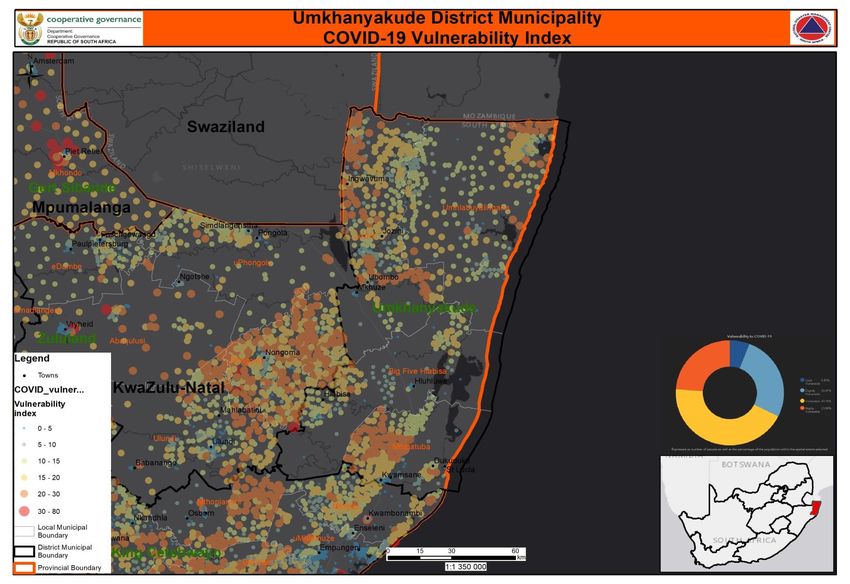
PROFILE: UMKHANYAKUDEDISTRICT      3

Table of Contents
  1. Executive Summary ...........................................................5
  2. Introduction: Brief Overview ...........................................6
  2.1 Location ................................................................................6
  2.3 Spatial Pattern .....................................................................7
  3. Social Development Profile..............................................8
  3.1. Key Social Demographics .............................................8
  3.1.1. ................................Population and Household Profile
        8
  3.1.2. ....................................... Race, Gender and Age Profile
        9
  3.4 Poverty Dimensions ........................................................10
  3.4.1 Unemployment/employment......................................11
  3.5 Education and skills profile ...........................................13
  4. Drivers of the economy...................................................13
  4.1 Economic overview .........................................................13
  4.2 Tourism ...............................................................................15
  5. Service delivery Service Delivery .................................15
  5.2 Human Settlements .........................................................16
  5.3 Waste Management .........................................................17
  5.4 Electricity ...........................................................................17
  6. Governance .......................................................................18
  6.1. Municipal performance ................................................18
  7. Project to diversify and grow people and economy 20
  7.1. Mkuze Regional Airport ...............................................20
  7.2. Mkuze Airport City Precinct Development ..............20
  7.3. Mkuze Agri-Hub .............................................................20
  7.4. Jozini Hidro-electric scheme ......................................20
  7.5. Umkhanyakude Broadband connectivity ................20
  7.6. Hotel School / Tourism Academy ..............................20
  7.7. Tourism Node - Bhanga Neck Community Lodge .21
  7.8 Environmental Features .................................................21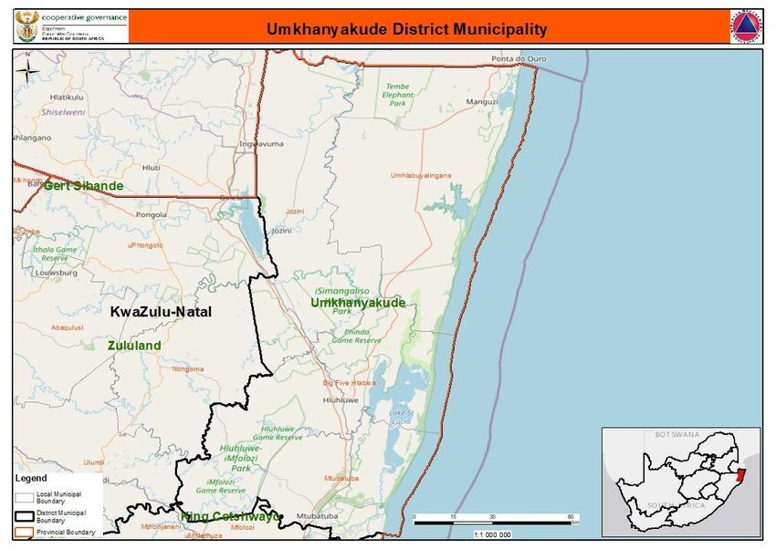
4
    PROFILE: UMKHANYAKUDEDISTRICT
PROFILE: UMKHANYAKUDEDISTRICT 5 1. Executive Summary The uMkhanyakude District Municipality known as “a model District Municipality in service delivery excellence” is a Category C municipality located along the coast in the far north of the KwaZulu-Natal Province. ‘uMkhanyakude' refers to the Acacia Xanthophloea fever tree and means ‘that shows light from afar'. The name reflects both the uniqueness of its people and their hospitality, as well as the biodiversity and conservation history that the region is very proud of. The Isimangaliso Wetland Park, formerly Greater St Lucia Wetland Park, encompasses the entire coastline. It shares its borders with Swaziland and Mozambique, as well as with the districts of Zululand and King Cetshwayo. It is the second-largest district in the province, and consists of the following four local municipalities: uMhlabuyalingana, Jozini, Big 5 Hlabisa and Mtubatuba. It is a very rural district, the largest town being Mtubatuba in the south, with Hluhluwe, Mkuze, Jozini, Kwangwanase and Ingwavuma further to the north. Covid 19 is not highly prevalent in the district at the moment. However, the increase movement of people where HIV infection is rampant might lead to changes in terms of numbers. The N2 running through the UKDM is a major strength to the district as it provides opportunities for growth and economic stimulation in the economy. Umkhanyakude is a poverty stricken district with high unemployment figures. Investment opportunities that exist in key catalytic projects for the area as planned and conceptualized are projects that include Mkuze Regional Airport, Jozini Hydro-electric Scheme, Makhathini Flats Development (Sugarcane, fruit and vegetables production and processing), expanded timber production, fishing industry based on natural resource harvest supplemented by aquaculture, expanded agricultural production of cashew and coconut oils and nuts for export, and establishment of high value–up market anchor tourism sites to ‘trigger’ further structured investment.
6
          PROFILE: UMKHANYAKUDEDISTRICT

The main economic drivers in the district include Community Services and Finance
(30.6% and 15.8% respectfully). Educational levels in the district is significantly lower
than the Provincial level and employment opportunities are limited.

 According to the South African multidimensional poverty index of 2016, the
 Umkhanyakude District is considered amongst the 10 Districts in South Africa with
 the greatest decline in MPI.

2. Introduction: Brief Overview

2.1 Location

Umkhanyakude District Municipality is one of the ten (10) districts (Category C
municipalities) of the KwaZulu-Natal Province. UMkhanyakude District Municipality is
located in the far Northern region of KwaZulu-Natal Province in South Africa
(32,014489; -27,622242). At 12 818 km² and with a population totaling 625,846, the
District is the 2nd largest District in KwaZulu-Natal, in terms of size, and its
neighbouring District, Zululand District Municipality second.
PROFILE: UMKHANYAKUDEDISTRICT 7 The District comprises four (4) local municipalities, namely : UMhlabuyalingana; Jozini; The Big 5 Hlabisa Municipality and Mtubatuba. The district has eighteen (18) traditional leaders in each of the four (local municipalities). The Jozini and Hlabisa municipalities have the largest traditional community areas, accounting for 13 (62%) of the total number of traditional communicates in the district. 2.2 Historical Perspective The municipality shares borders with two countries being Kingdom of ESwatini and Mozambique. UMkhanyakude District is home to a World Heritage Site known as Isimangaliso Wetland Park encompassing the entire coastline of more than 200km. The Map below (Map 1) shows the location of the Umkhanyakude District Municipality in relation to other Districts in the Kwa-Zulu Natal province. 2.3 Spatial Pattern The settlement type in UKDM dominated by population residing in traditional; areas, which is in excess of 90%, and is by far the highest figure of all districts within the province. Fifty five (55.7%) of land cover within the district is natural land. Approximately 17.9% of the District is being used for agricultural purposes, with the majority of agricultural land being focused within the Mtubatuba Local Municipality (LM). Wetland accounts for 26.2% of the land in within the Big 5 False Bay Local Municipality. Approximately 33.2% of the District is formally protected and forms part of Nature Reserves. In terms of the Provincial Growth and Development Plan all towns (Mbazwana, Jozini, Hluhluwe, Mtubatuba, Hlabisa & Manguzi) has been identified as Quaternary Development Nodes.
8
                PROFILE: UMKHANYAKUDEDISTRICT

    Households, Wards and Traditional Leaders
                                                        No    of     No    of     Traditional
       Local Municipality       No of Households
                                                        Wards        Leaders
       Umhlabuyalingana         39 614                 18            4
 1.

       Jozini                   44 584                 20            7
 2.
       Mtubatuba                25 255                 20            1
 3.
       Big 5 Hlabisa            41 792                 13            6
 4.

       UKDM                     151 245                71            18
Source: Umkhanyakude District Municipal IDP 2020/2021

3. Social Development Profile

3.1. Key Social Demographics

         3.1.1. Population and Household Profile

According to the community survey done in 2016, the total population of the
Umkhanyakude District is 689,090 with a growth of 9,2% between 2011 and 2016.
The District had a modest average annual population growth rate of 0.9% per annum
between 2001 and 2011. The HDI of the district declined from a figure of 0.46 in
2000 to 0.44 in 2010 and is significantly lower than the comparative overall provincial
figure (0.44 compared to 0.49). Life expectancy at birth is lower than the average figure
for KZN which currently sits at 56.1 years.

    Population Figures
                UMhlabuyalingana          Jozini   Big 5 Hlabisa   Mtubatuba     Umkhanyakude

 2011    156,736              186,502   107,183                    175,425      625,846
 2016    172,077                        116,622                    202,176      689,090
 %       8,9%                5,9%       8,7%                       3,2%         9,2%
 Growth
Source: STATS SA Community Survey, 2016
PROFILE: UMKHANYAKUDEDISTRICT 9
uMkhanyakude Population growth 2009 -
2019
2.0%
1.8%
1.6%
1.4%
1.3% 1.3% 1.3%
1.2% 1.2% 1.2% 1.2% 1.2% 1.2% 1.3% 1.2%
1.1%
1.0%
0.8%
0.6%
0.4%
0.2%
0.0%
2009 2010 2011 2012 2013 2014 2015 2016 2017 2018 2019
National Total KwaZulu-Natal uMkhanyakude
3.1.2. Race, Gender and Age Profile
STATSSA Community survey 2016 depicts Umkhanyakude’s population as youthful,
with 50.7% (349 279) of the population younger than 18 years, approximately 20%
higher than the provincial figure. The age group 18 to 64 years is at 45.4% (312 695),
approximately 10% lower than the provincial average.
3.2 Health Profile
According to the District Health Plan for 2018/19, UMkhanyakude has five district
hospitals, 57 clinics, including five gateway clinics, 17 mobile clinics servicing 238
mobile stopping points, and seven high transmission area (HTA) sites (two fixed and
five mobile). The new Jozini Community Health Centre (the first in the district) opened
in the first quarter of 2018/19.
Social vulnerability in the province is said to be very high due to the following driving
forces:
a) It has the highest malaria prevalence in the country;
b) Twenty to thirty percent (20-30%) of adults are HIV positive. The HIV prevalence
rate is at 41.1%, higher than both the provincial and national average of 37.4%
and 29.5% respectively. UKDC is the second highest amongst the districts in the10
PROFILE: UMKHANYAKUDEDISTRICT
province;
c) Tuberculosis is a major cause of mortality
d) The increase and occurrence of severe malnutrition of children younger than
5 years
e) A large number of people from the neighbouring countries cross the border
receive healthcare in Umkhanyakude
3.3 COVID-19
As at 12 June 2020, the district registered 33 active cases, 29 recoveries, 4 active and
zero death. Three hundred and fourteen thousand two hundred five (314 205) people
were screened and 4 064 were tested. The incidence risk is at 0,6%.
The KZN province currently has public mortuaries in all the Districts and three (3) are
located in the Umkhanyakude District in the towns of Mtubatuba, Mkuze and Manguzi.
These mortuaries are said to be at various levels of capacity and operation; and
therefore require further formal confirmation from the Department of Health (DoH) on
their readiness for use for the COVID-19 pandemic mortal remains. The district has
made available sixty eight (68) beds for isolation and quarantine sites
3.4 Poverty Dimensions
Umkhanyakude District is considered amongst the 10 districts in South Africa with the
highest Multi poverty index (MPI). The majority of the population live below the poverty
line. As such there is high occurrence of malnutrition in children younger than 5 years.
The table below depicts poverty measures for Census 2001 and Census 2011 at
municipal level in the district.
Poverty dimensions
Census 2001 Census 2011
Headcount (H) Intensity (A) SAMPI (HxA) Headcount Intensity SAMPI (HxA)
(H) (A)
Jozini 43,0% 43,6% 0,19 22,3% 42,6% 0,09PROFILE: UMKHANYAKUDEDISTRICT 11 Big Five 36,0% 43,6% 0,16 17,5% 42,1% 0,07 Hlabisa 33,5% 43,7% 0,15 16,1% 41,8% 0,07 Mtubatuba 27,2% 43,9% 0,12 11,6% 41,5% 0,05 Source: STATS SA 3.4.1 Unemployment/employment The unemployed population in UKDM is similar to the overall figures for KZN. The district has a youthful population and 35.2% of the unemployed population is younger than 25 years of age, with a further 34.9% between 25 and 34 years. This implies that more than 70% of the unemployed population is younger than 35 years of age. Age breakdown of Unemployed Population (UKDM vs KZN)
12
             PROFILE: UMKHANYAKUDEDISTRICT

     Unemployment rate in uMkhanyakude

3.4.2      Human Development Index

The Gini coefficient, for Umkhanyakude in 2019 was 0,56 and KZN 0,63 (HIS Markit),
which was the highest in the province.
Table 11: HDI per Province

3.4.3      Crime

Umkhanyakude District has eleven police stations under each local municipality. The
commonly reported crime is in but not limited to the following categories: assault with
the intent of inflicting serious bodily harm; contact crime; property related crime;
burglary at residential properties, drugs and sexual offences

Crime statistics per SAPS Station between 2014-2019

 Station       2018-2019    2017-2018        2016-2017   2015-2016      2014-2015
 Emanguzi      3262         3088             3039        2825           2971
 Ezibayeni     430          357              414         417            392
 Hlabisa       1550         1626             1432        1234           1330
 Hluhluwe      2184         2021             2081        2478           2623
 Ingwavuma     1449         1418             1396        1614           1625
 Jozini        2919         2849             2868        3061           2765
 Kwamsane      5822         5839             5482        5278           5365
 Mbazwana      1525         1150             2197        2562           2388
PROFILE: UMKHANYAKUDEDISTRICT 13
Mkhuze 1293 1247 1156 1321 1272
Mtubatuba 5037 4978 5621 6059 5642
Ndumo 919 988 870 802 715
Grand
Total 26390 25561 26556 27651 27088
Source: saps.gov.za
3.5 Education and skills profile
Approximately 14% of the unemployed population UKDM has received no formal
schooling and only 17% has primary level education. A largest proportion of the
unemployed population has completed grade 12 education and approximately 30%
has secondary education. A trend is that only a fraction of the unemployed population
has completed any form of tertiary education and this is a pattern across the five local
municipalities. This implies that the completion of secondary school education
provides very little guarantee of finding any form of formal employment within the
district. It also confirms the importance of tertiary education to successfully enter the
employment market, even in districts with limited availability of formal sector
employment opportunities (IDP, 2019/20:82).
There is high level of adult illiteracy in the district. More than 27% and 22% of the adult
female and male population, respectively, have not received any form of schooling.
These figures are significantly higher as compared to the provincial figures of 13% and
8% respectively. The proportion of the adult population in the district with tertiary
education is less than halve the comparative figure for the province, which is 2.5%.
4. Drivers of the economy
4.1 Economic overview
Although growing from a small base, the economy experienced significant
growth in excess of 9% per annum, especially in the period from 2000 onwards.
The key economic structure and trends in the District can be summarised as
follows:14
PROFILE: UMKHANYAKUDEDISTRICT
a) The two main sectors of economic activities are agriculture and tourism.
b) Mtubatuba and Jozini Local Municipalities account for approximately R1.9
and R1.7 billion of GVA in 2011 respectively, as they are two dominant local
economies within the district;
c) Dominant economic sectors in UKDM as measured by GVA is the retail,
catering and accommodation sector accounting for R1.45 billion in 2011, the
manufacturing sector (R1.37 billion), and the general government services
sector (R1.34 billion); • The manufacturing sector increased its contribution
to total GVA from 10.3% to 19.1%, and the retail, catering and
accommodation sector its contribution from 13.5% to 20.3%;
d) Agricultural sector showed some significant growth of approximately 5.5%
per annum over the period 1995 to 2011. However, there was a decline
thereafter, 9000 over the period from 2000 to 2005 but thereafter decreased
significantly to a total estimated figure of 4983 by 2010;
e) There are undeveloped mineral resources that can contribute to future
economic growth.
f) There are identified economic opportunities to tourism and agriculture to the
uMkhanyakude economy, with current projects and implementation plans
already in place.
g) UKDM is South Africa’s nearest access point into Mozambique and is also
close to Swaziland. This provides opportunity for tourism and other
economic activity both directly and from spillovers/spinoffs.
h) The number of formal employment opportunities in the agricultural sector
remained relatively stable
The table below gives a summary of gross value add (GVA) for Umkhanyakude
District Municipality.
Sector's share of regional total (%)
GVA
2008 2018
1. Agriculture 17.8% 12.7%
2. Mining 1.9% 1.4%
3. Manufacturing 7.9% 8.0%
4. Electricity 2.9% 6.0%PROFILE: UMKHANYAKUDEDISTRICT 15
5. Construction 4.4% 3.9%
6. Trade 14.8% 13.2%
7. Transport 8.6% 8.4%
8. Finance 15.0% 15.8%
9. Community services 26.8% 30.6%
Total Industries 100.0% 100.0%
Source: KZN Department of Economic Development, Tourism and Environmental Affairs
4.2 Tourism
Tourism potential of UKDM exists in terms of the biodiversity, recreational
opportunities, visual appeal, heritage and the culture of the district. This creates an
opportunity for the existence of the SMME’s in the tourism sector, with its access to
Mozambique and Swaziland. This provides opportunities for the inflows and outflows
of tourists and other economic activities. iSimangaliso Wetlands Park is a large
contributor to tourism and socio-economic related benefits in the district.
5. Service delivery Service Delivery
The 2019/2020 IDP of the Umkhanyakude District Municipality approved by Council
reports that the major basic service challenge faced by the district is the backlog of
eradicating high levels of old infrastructure. The maintenance costs of the old
infrastructure are very high and have an adverse effect in the provision of service
delivery due to limited funding. The IDP further indicates that there is also a challenge
of high levels of illegal connections which further strains the available resources.
5.1 Water and Sanitation
The district has a challenge in terms of the provision of water and sanitation. Only
13.1%, of households have access to a flush toilet, connected to either a sewerage
system or a septic tank.
About 18.4% of households in UKDM do not have access to any form of sanitation
facilities compared to only 6.3% at provincial level. The dominant forms of sanitation
infrastructure in the district include ventilated improved and unimproved pit latrines,16
PROFILE: UMKHANYAKUDEDISTRICT
benefiting which 25.6% and 19.7% of households respectively. (IDP, 2019/20: 88).
The proportion of households with access to flush toilets connected to a sewerage
system in UKDM (9.9%) is the lowest amongst all districts in the province.
In terms of water provision, 30% of households are utilising untreated sources of water
directly from springs, dams or rivers, which is significantly higher than the provincial
total of 13% and only a proportion of households is provided with water through
regional and local water schemes. The District ranks at number 14 on the provincial
wastewater Green drop performance log of WSAs.
5.2 Human Settlements
The Umkhanyakude district has three categorized of household, namely; formal,
informal and traditional type housing. Approximately 70% of households resided in
formal housing in 2016. Traditional type housing accounted for 25% in the same year.
The district has a total number of 151 245 households located within 71 wards and
represented by 18 traditional councils, as per the table below.
Households Types by Municipality 2016
Number of
Main Dwelling
households
Municipality Formal Informal Traditional
Total
housing housing housing
Umhlabuyalingana 39 614 27 731 968 10 896
Jozini 44 584 29 196 1 681 13 111
Mtubatuba 41 792 31 439 1 843 7 442
Hlabisa – Big 5 25 255 17 724 536 6 856
DC27: uMkhanyakude 151 245 106 090 5 028 38 306
Source: STATSSA – Community Survey 2016PROFILE: UMKHANYAKUDEDISTRICT 17 5.3 Waste Management The provision of regular refuse removal services is limited to a number of the larger centres within the district. Overall the proportion of households provided with a weekly household refuse removal services is less than 10% compared to the overall provincial figure of 52%.74% of households in the district make use of own refuse dumps, with a further 13% without any form of rubbish disposal. The availability of this service does not vary greatly amongst the local municipalities, although the proportion of households provided with regular weekly refuse removal service is slightly higher in the Big 5 False Bay municipality (18%), Mtubatuba (13%) and Jozini (11%) municipalities. The spatial analysis confirms the widespread use of own refuse dumps in settlements right across the UKDM area of jurisdiction. 5.4 Electricity Significant progress has been made with the provision of basic electricity to households across all five local municipalities, between 2001 and 2011. This ranges from a relatively modest increase (from 6% to 14%) in Umhlabuyalingana LM, to increases of 27% in the Hlabisa LM (from 28% to 55%) and 24% in the Big 5 False Bay LM (from 18% to 42%). Although there is an increase in the provision of electricity, the district has there are significant backlogs. Only 38.4% of households in the district have access to electricity for lighting purposes and 32.1% for cooking (the comparative provincial level figures are 77.9% and 68.8% respectively). About 56% of the district households are reliant on candles as source of lighting, compared to the overall provincial figure of 19.6%. Umhlabuyalingana and Jozini are the mostly affected local municipalities, with only 13% and 29% of households, respectively, with access to electricity for lighting purposes.
18
           PROFILE: UMKHANYAKUDEDISTRICT

6. Governance

6.1. Municipal performance

According to Municipality IQ-/Municipality money, the district received a qualified audit
outcome for 2017/18 financial year. Total revenue (excluding capital transfers and
contributions) in 2018/19 amounted to R433 033 000. The municipality has
progressed from an immature to fairly mature stage in terms of risk. The overall
internal controls are improving, and the process of risk management and assessment
has highlighted progress made during the prior year. Recommendations made by the
risk committee have been implemented for continuous improvement. The risk
committee does however want to see the municipality continue on an upward
trajectory and in this regard have set forth some recommendations for the audit
committee to include in their report to council.

Policy frameworks and legislation are implemented accordingly to ensure good
governance in the district. There is a strong shift in terms of organizational culture in
the effective and efficient management and administration.

6.2 Traditional Affairs Governance
   The Khoi-San consists of five main groupings namely the Cape-Khoi, Griqua,
   Koranna, Nama and San. Many of these main groupings have various
   subgroupings.
   While legislation has over many decades made provision for the statutory
   recognition of traditional communities and leaders, there has never before been
   provision for similar recognition of the Khoi-San communities and leaders.
   The Traditional and Khoi-San Leadership Act, 2019 (Act No. 3 of 2019), which was
   published in the Government Gazette on 28 November 2019, is of historic value
   as it is the first legislation that provides for the statutory recognition of the Khoi-
   San communities and leaders, provided they meet the criteria contained in the Act.
   However, the Act has not yet commenced, because its commencement date has
   not yet been proclaimed. Once the Act commences, a Commission on Khoi-San
   Matters will be established to receive and investigate applications for recognition
   of Khoi-San communities and leaders.

     The Commission will make recommendations to the Minister in this regard and the
     Minister will have the power to recognise such communities and leaders. There is
     thus currently no legally recognised Khoi-San communities or leaders in South
     Africa. The Act makes provision for two Khoi-San leadership positions namely
     senior Khoi-San leaders and branch heads. The recognised senior Khoi-San
     leaders will have personal jurisdiction over their communities.
PROFILE: UMKHANYAKUDEDISTRICT 19 In the case of traditional leaders, they are legally recognised at all levels (kingship, queenship, principal traditional leadership, senior traditional leadership and headmen/headwomen). However, although the existing Traditional Leadership and Governance Framework Act, 2003 (Act No. 41 of 2003)(Framework Act), makes provision for the establishment of traditional leadership structures such as kingship or queenship councils, principal traditional councils and traditional councils, the timeframes within which these structures had to be legally constituted or reconstituted have lapsed. Until such time that the relevant traditional leadership structures have been legally constituted or reconstituted, their legal status and standing will remain uncertain and could be challenged. This may also impact negatively on the statutory duties and responsibilities of such structures. Currently, there is no enabling legislation to legally reconstitute them. The Traditional Leadership and Khoi-San Leadership Act will provide enabling legislation for their legal constitution. However, the Act has not yet commenced due to the reasons alluded above and therefore the enabling provisions in the Act cannot be used at this stage to reconstitute these structures. Umkhanyakude District has a Local House of Traditional Leaders comprising eighteen traditional (18) leaders with eighteen traditional councils under each local municipality. 6.2.1 Participation of traditional leadership in municipal council processes. In KwaZulu Natal traditional leaders have been identified for the purposes of participation as contemplated in the Act and it was done through a Provincial Gazette as required by section 81(2) of the Act. Traditional leaders identified participate in the proceedings of the municipal councils. There is a system of rotation of participating traditional leaders on a five-year cycle. The municipal council does not allow traditional leaders to address the council nor do they sit in municipal committees. However, municipalities pay the participating traditional leaders are paid out of pocket expenses (subsistence and travelling expenses). The table below depicts the number of participating traditional leaders per in uMkhanyakude District and each local Municipality. uMkhanyakude District Municipality 5 uMhlabuyalingana Local Municipality 4 Jozini Local Municipality 6 Big Five Hlabisa Local Municipality 5 Mtubatuba Local Municipality 1
20
           PROFILE: UMKHANYAKUDEDISTRICT

7. Project to diversify and grow people and economy

7.1. Mkuze Regional Airport
     Out of the 76 hectares of land owned by the municipality through Umkhanyakude
     Development Agency, 40 hectares will be utilised for the regional airport
     development of which 36 hectares will be for commercial use for retail, hospitality,
     light industrial, residential, commercial use.

7.2. Mkuze Airport City Precinct Development
     The objective of the project is to develop mixed use nonaviation land uses. The
     project will develop Mkuze town and the uMkhanyakude District as a catalyst for
     to stimulate the economy development.

7.3. Mkuze Agri-Hub
     The project is primarily linked with the development of an Agri-Park within UKDM
     and will provide a network of contacts between producers, markets and
     processors, and also the physical infrastructure required for the Agri-Park.

7.4. Jozini Hidro-electric scheme

     The proposed Jozini Hydro-Power Plant at Jozini Dam is located at South Africa's
     fifth largest dam with a capacity of 2,445,000,000 m3. The original design of the
     dam made provision for the installation of hydro-power turbines on the southern
     bank of the river where a series of draw off pipes have been installed to draw from
     the discharge line to the irrigation channel.

7.5. Umkhanyakude Broadband connectivity
     To develop district wide broadband infrastructure, including fiber optic lines and
     towers, to facilitate easy access to ICT eco systems and access to internet. The
     project will cover the whole district.

7.6. Hotel School / Tourism Academy
     UMkhanyakude Region, which has the highest concentration of game reserves in
     the country, is one of the top tourist destination within the province of KwaZulu
     Natal, with a vibrant hospitality sector hence a need for a world standard academic
     hospitality institution.
PROFILE: UMKHANYAKUDEDISTRICT 21
7.7. Tourism Node - Bhanga Neck Community Lodge
The Revitalisation of a community-owned lodge that are struggling to operate or
currently dysfunctional. The lodge is located within the IsiMangaliso Wetland Park,
a UNESCO World Heritage Site, and close to a lot of other tourist attractions within
the region.
7.8 Environmental Features
A comprehensive SWOT analysis of the environment is included in the draft
2020/21 IDP. The district faces grave challenges in terms of capacity to support
and manage its vast natural resource base that includes commercial agriculture,
traditional settlements and subsistence agriculture, coastal plains and
mountainous areas.
It is reported that there is an inadequate understanding of the full impacts of climate
change to the district in terms of its biodiversity, agricultural resources, the
availability of water sources, human health and the vulnerability of coastal areas to
rising sea levels and greater storm intensities (erosion of coastline), all in the face
of the district’s extremely hot, dry and hostile climate.
Climate Change Forecasting
Assessment Criteria Score
Disaster Management Framework approved (S42) 1
Appointment of Head of Disaster Management Centre (S45) 1
Adequate personnel capacity (S43) 1
Disaster Management Centres (DMC) Physical facilities (Building, etc.)
1
(43)
IT System and other equipment (S30, 44) 0,5
Risk assessment on prevalent hazards (S47) 1
Disaster Response (S49,54,55) 0,5
Annual Report (S50) 0,5
Effective functioning of advisory forum (involvement of stakeholders)
1
and coordination structures (S51)
Disaster Management Plans Plan & IDP Process (S 52 & 53) 1
Stakeholder and Community Capacity in Disaster Risk Reduction (S47) 1
Funding and capacity (S52, 56, 57) 122
PROFILE: UMKHANYAKUDEDISTRICT
Umkhanyakude DMC at a glance
Funding and…
Stakeholder and…
Disaster…
Effective…
Annual Report…
Disaster…
Risk assessment…
IT System and…
Disaster…
Adequate…
Appointment of…
Disaster…
0 0.25 0.5 0.75 1 1.25
8. Key Recommendations
(a) Council should ensure that risk forms part of the strategic planning process of
the municipality for the 2019/2020 year
(b) All directors continue to present their risk progress on a quarterly basis to the
risk management committee. Any director who is not present should sent a
representative in his/her place and continuous absenteeism should be reported
to council
(c) The quarterly risk registers form part of respective portfolio meetings and part
of respective director’s scorecards.
(d) Fraud controls are prioritised in terms of budgeting and resources and fraud
risk process be undertaken during the upcoming 6 months
(e) Council should ensure prioritisation of risk management in terms of capacity &
skills – The appointment of a skilled person in the position of internal audit and
risk is urgent in this regard
(f) The risk committee and audit committee work together with management to
assist in the issue of improving the municipality’s audit opinion
(g) The process of training of risk to councillors and management be done in the
upcoming year.PROFILE: UMKHANYAKUDEDISTRICT 23 8.1 Investor and sponsorship opportunities The information from the UMkhanyakude District Health Plan 2018/19, being the service delivery platform of the district, indicates that there are five district hospitals, 57 clinics, including five gateway clinics, 17 mobile clinics servicing 238 mobile stopping points, and seven high transmission area (HTA) sites (two fixed and five mobile). The new Jozini Community Health Centre (the first in the district) opened in the first quarter of 2018/19. Mpophomeni clinic (medium sized) commenced operations in the second quarter of 2018/19. Seven clinics provide a 24-hour open- door service and a further 38 clinics provide after-hours emergency care.
24
     PROFILE: UMKHANYAKUDEDISTRICT
You can also read