Updated Kwale North Dune and maiden Bumamani Mineral Resources estimates - HotCopper
←
→
Page content transcription
If your browser does not render page correctly, please read the page content below
ASX, AIM and Media Release
19 February 2021

Updated Kwale North Dune and maiden Bumamani Mineral Resources estimates
Key Points
•    As part of the pre-feasibility study currently underway to assess the viability of mining the Kwale North Dune and
     Bumamani deposits, seeking to extend the mine life of Kwale Operations, additional drilling and mineralogy
     assessments have been conducted.
•    The Kwale North Dune Mineral Resources estimate has increased by 13% to 194 million tonnes at an average HM grade
     of 1.5%, containing 2.9Mt HM, based on a 1% HM cut-off grade.
•    99% of the Kwale North Dune Mineral Resources estimate is now reported in the Measured and Indicated categories.
•    The maiden Bumamani Mineral Resources estimate is 5.9 million tonnes at an average HM grade of 1.9%, containing
     0.115Mt HM, based on a 1% HM cut-off grade.
•    The pre-feasibility study for the Kwale North Dune and Bumamani deposits is due for completion early in Q2 2021.

African mineral sands producer, Base Resources Limited (ASX / AIM: BSE) (Base Resources) is pleased to provide an update to the Kwale
North Dune Mineral Resources (2021 Kwale North Dune Mineral Resources) estimate and announce a maiden Bumamani Mineral
Resources estimate (2021 Bumamani Mineral Resources) at its 100% owned and operated mineral sands operations in Kwale County,
Kenya (Kwale Operations).

The 2021 Kwale North Dune Mineral Resources and 2021 Bumamani Mineral Resources estimates are being presented together
because of the close proximity of the underlying deposits and as these deposits are the subject of a single pre-feasibility study (the
Kwale North Dune PFS) being undertaken to assess their potential to extend the mine life of Kwale Operations. The Kwale North Dune
PFS commenced in early 2020 and is due for completion early in the second quarter of 2021.

Since announcement of the maiden JORC 2012 North Dune Mineral Resources estimate in May 2019 (2019 Kwale North Dune Mineral
Resources) 1, Base Resources has carried out additional drilling, assaying and mineralogy studies of the Kwale North Dune to improve
the confidence of the Mineral Resources estimate and further the Company’s understanding of the deposit. As a result of this additional
work, 99% of the 2021 Kwale North Dune Mineral Resources estimate is now reported in the Measured and Indicated categories.
Material tonnage for the 2021 Kwale North Dune Mineral Resources estimate has also increased by 13% and contained heavy mineral
(HM) has increased by 12% from the 2019 Kwale North Dune Mineral Resources estimate.

The 2021 Kwale North Dune Mineral Resources are now estimated to be 194 million tonnes (Mt) at an average HM grade of 1.5% for
2.9Mt of contained HM, at a 1% HM cut-off grade.

The Bumamani deposit is situated approximately 1.5km south of the North Dune deposit (Figure 1) and was discovered by Base
Resources in 2017 when drilling to test for mineralisation in the north-east sector of the Kwale Prospecting Licence PL/2018/0119
(PL119). At that time, taking into account the results at hand and the small size of the deposit indicated by such results, it was decided
that any Mineral Resources estimate would be deferred until the full drilling program planned for the north-east sector was able to be
completed and the full results incorporated into the estimation process. Due to ongoing community access issues, Base Resources has
not been able to complete that program. However, with commencement of the Kwale North Dune PFS, the Bumamani deposit has
now been revisited due to its proximity to the Kwale North deposit and a Mineral Resources estimate completed to allow its inclusion
in that study.

1
  Refer to Base Resources’ market announcement “Mineral Resource for Kwale North Dune deposit” released on 1 May 2019, which is available at
https://baseresources.com.au/investors/announcements/

                                                                                                                                               Page 1 of 49
The maiden 2021 Bumamani Mineral Resources estimate was developed from 2,977.5m of drilling from 183 holes and is 5.9Mt at an
average HM grade of 1.9% for 0.115Mt of contained HM, at a 1% HM cut-off grade.
The 2021 Kwale North Dune Mineral Resources and the 2021 Bumamani Mineral Resources estimates are reported in accordance with
the JORC Code. The information prescribed by the ASX Listing Rules, including a summary of the information material to understanding
each Mineral Resources estimate in respect of the prescribed matters, is set out in the sections below. For each Mineral Resources
estimate, such information should be read in conjunction with the explanatory information provided in respect of the applicable
estimate for the purposes of Sections 1 to 3 of Table 1 of the JORC Code - see Appendix 1 to this announcement in the case of the 2021
Kwale North Dune Mineral Resources estimate and Appendix 2 in the case of the 2021 Bumamani Mineral Resources estimate.
Table 1: 2021 Kwale North Dune Mineral Resources estimate compared with the 2019 Kwale North Dune Mineral Resources estimate.
2021 2019
as at 19 February 2021 as at 1 May 2019
Category Tonnes HM HM SL OS HM Assemblage Tonnes HM HM SL OS HM Assemblage
ILM RUT ZIR ILM RUT ZIR
(Mt) (Mt) (%) (%) (%) (%) (%) (%) (Mt) (Mt) (%) (%) (%) (%) (%) (%)
Kwale North Dune Mineral Resources
Measured 119 1.8 1.5 37 1 42 13 6 - - - - - - - -
Indicated 73 1.0 1.4 37 2 50 14 6 136 2.1 1.5 38 2 45 12 5
Inferred 2 0.0 1.2 37 3 50 15 7 34 0.5 1.4 36 3 46 13 6
Total 194 2.9 1.5 37 2 45 13 6 171 2.6 1.5 38 2 45 12 5
Table subject to rounding differences, resources estimated at a 1% HM cut-off grade.
Table 2: Maiden 2021 Bumamani Mineral Resources estimate.
2021
as at 19 February 2021
Category Tonnes HM HM SL OS HM Assemblage Tonnes HM HM SL OS HM Assemblage
ILM RUT ZIR ILM RUT ZIR
(Mt) (kt) (%) (%) (%) (%) (%) (%) (Mt) (Mt) (%) (%) (%) (%) (%) (%)
Bumamani Mineral Resources
Measured 3.0 66 2.2 19 2 48 15 7.5
Indicated 2.6 45 1.7 23 5 47 16 7.7
N/A
Inferred 0.3 4 1.4 27 6 41 14 7.8
Total 5.9 115 1.9 21 4 47 15 7.6
Table subject to rounding differences, resources estimated at a 1% HM cut-off grade.
Further information relevant to both Mineral Resources estimates
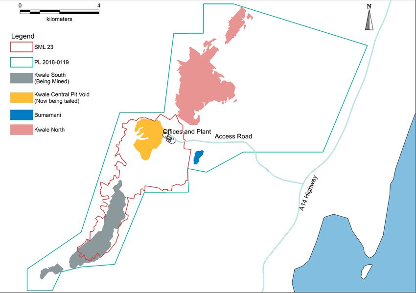
Kwale Operations is located on Special Mining Lease 23 (SML 23), which lies within PL119. The Prospecting Licence covers an area of
88.7km2, which includes the Kwale North and Bumamani deposits, and is located approximately 50 kilometres south of Mombasa and
approximately 10 kilometres inland from the Kenyan coast (Figure 1).
The Kwale Project initially comprised three areas that contained concentrations of heavy minerals. They were the South Dune, Central
Dune (now totally depleted by mining and currently the repository for sand tailings from the South Dune) and the North Dune deposits
(Figure 2), with the Bumamani deposit only being discovered in 2017 after mining operations had commenced.
The project was initially owned by Tiomin Resources Inc. (Tiomin) which conducted drilling in 1997 and then by Base Titanium Limited
(a wholly owned subsidiary of Base Resources) which purchased the project late in 2010 and commenced confirmatory drilling of the
Central, South and North Dune deposits. The North Dune deposit was initially excluded from the project’s Mineral Resources on the
basis of HM grade and the then prevailing economic conditions. However, in 2018, it was decided to re-evaluate the potential of the
Page 2 of 49
North Due in light of improved economic conditions, refined resource definition methodology and with insights gained from five years
of operations on the Central Dune. Following that decision, the 2019 Kwale North Dune Mineral Resources estimate was announced.

The rocks of the area are of sedimentary origin and range in age from Upper Carboniferous to Recent. Three divisions are recognised:
the Cainozoic rocks, the Upper Mesozoic rocks (not exposed within the area) and the Duruma Sandstone Series giving rise to the
dominant topographical feature of the area: the Shimba Hills. The Shimba grits and Mazeras sandstone are of Upper Triassic age and
form the Upper Duruma Sandstone.

The Magarini sands form a belt of low hills running parallel to the coast. They rest with slight unconformity on the Shimba grits and
Mazeras sandstone. This formation was deposited during Pliocene times and consists mainly of unconsolidated fluviatile sediments
derived from the Duruma Sandstone Series.

The Kwale deposits are an aeolian subset of the Magarini sands and are generally poorly stratified and contain a fraction of clay, which
for the North Dune and Bumamani deposits is approximately 37% and 21%, respectively. Heavy minerals, mainly ilmenite, rutile and
zircon, are locally concentrated and are abundant in some places, giving rise to the deposits.

Further information specific to the 2021 Kwale North Dune Mineral Resources estimate
The geological interpretations for the Kwale North Dune deposit considered the data in the drill logs, HM assay results, microscopic
logging of HM sinks, detailed mineralogy and knowledge gained from mining the Central Dune and South Dune deposits. Four geological
domains have been identified at the Kwale North Dune deposit. These were used and honoured during the geological modelling (Figure
3).

The uppermost zone at the Kwale North Dune deposit, referred to as Ore Zone 1, is a dark brown, predominantly fine grained, well
sorted silty sand with very little induration and is similar to the Ore Zone 1 units in the other Kwale deposits. Mineralogically, it is
characterised by clean, glossy and rounded HM grains with an average valuable heavy mineral (VHM) content of approximately 75%.

Ore Zone 4 lies below Ore Zone 1, with an indurated paleo-surface separating the two zones, as observed in the field through difficult
drill bit penetration, and in HM sink logs, exhibiting elevated iron oxides. The Ore Zone 4 host is higher in slimes with difficult washability
and the grain sorting is generally poor. It is slightly lower in VHM content (71%), often with elevated iron oxides and alumino-silicate
minerals (kyanite, andalusite and sillimanite). Ore Zone 4 is considered a fluvial deposit based on the difficulty of wash and the poor
grain sorting.

Ore Zone 5 lies below Ore Zone 4 and is separated from that zone by a lateritic paleo-surface and is also hosted in a fluviatile clay-rich,
poorly sorted formation. It is distinguished mineralogically by an increased amount of almandine garnet that reports to the magnetic
fraction, significantly increasing magnesium, manganese, aluminium and silicon in the oxide chemistry. As a result of this, Ore Zone 5
has a notably lower average VHM content (44%).

The Basement Zone lies below Ore Zone 5 and is typically hosted in weathered variants of the Mesozoic (Permo-Triassic) Duruma
Sandstones. It does contain mineralisation which was reported in the 2019 Kwale North Dune Mineral Resources estimate as Ore Zone
10. However, it has a VHM content of just 10% being predominantly titano-haematite (
The predominantly three metre sample intervals in the 2010 and 2012/13 drilling were replaced by sampling at 1.5 metre intervals for
the 2018/19 drill program to provide greater control on geological boundaries. Sample sizes averaged close to 3kg at this sample
interval when collecting 25% of the rotary splitter cycle. Samples were dried, weighed, and screened for material less than 45µm
(slimes) and +1 mm (oversize).

Approximately 100 grams of the screened sample was subjected to a HM float/sink technique using the heavy liquid, lithium
polytungstate (LST) with a specific gravity of 2.85gcm-3. The resulting HM concentrate was dried and weighed as were the other
separated constituent size fractions (the minus 45µm material being calculated by difference).

Mineral assemblage analyses were conducted by Base Resources to characterise the mineralogical and chemical characteristics of
specific mineral species and magnetic fractions. These mineral assemblage samples were subjected to magnetic separation using a
Mineral Technologies induced-roll magnetic separator which captures magnetic (mag), middling (mid) and non-magnetic (non-mag)
fractions. The mid and mag fractions were combined and, with the non-mag fraction, were subjected to XRF analysis using a Bruker,
S8 Tiger XRF.

Data from the mag and non-mag XRF analyses are processed through an algorithm (Minmod) that runs approximately 100,000 iterations
in assigning key chemical species to derive a calculated mineralogy determination.

Drill hole collar and geology data was captured by industry-specific, field logging software with on-board validation. Field and assay
data were managed in a MS Access database and subsequently migrated to a more secure SQL database.

Standard samples were generated and certified for use in the field and laboratory. Accuracy of HM and slimes (SL) analysis was verified
by using the standard samples and monitored using control charts. Standard errors greater than three standard deviations from the
mean prompted batch re-assay. A standard precision analysis was conducted on the key assay fields: HM, SL and Oversize (OS) for both
laboratory and field duplicate samples. Normal scatter and QQ plots were prepared for HM, SL and OS for laboratory and field
duplicates.

A twin drilling program was introduced for the 2018 program to quantify short-range variability in geological character and grade
intersections. A water injection versus dry drilling assessment was included in the twin drilling analysis. Field and laboratory duplicate,
standard and twin drilling analysis show adequate level of accuracy and precision to support resource classifications as stated.

A topographic DTM was prepared by Base Resources based on a LIDAR survey.

Construction of the geological grade model was based on coding model cells below open wireframe surfaces, comprising topography,
geology (Ore Zones 1, 4, and 5) and basement (Figure 3). Model cell dimensions of 50m x 50m x 1.5m in the XYZ orientations were
utilised.

Interpolation was undertaken using various sized search ellipses to populate the model with primary grade fields (HM, SL and OS), and
index fields (hardness, induration percent, mineralogy). Inverse distance weighting to a power of three was used for primary assay
fields whilst nearest neighbour was used to interpolate index fields. Figure 5 shows an oblique view of the model coloured by HM
grades.

A fixed bulk density of 1.7 (t/m3) was applied to the 2021 Kwale North Dune Mineral Resources model. This bulk density was selected
based on operational experience in the Kwale Central and South Dune deposits and because no bulk density sampling was undertaken.
This is considered to be a conservative estimate of bulk density.

The Kwale North Dune deposit, being similar in nature to the Kwale South Dune deposit currently being mined, is considered amenable
to being mined and processed in the same way. That is, by using the existing plant and equipment at the Kwale Operations: hydraulic
mining, spiral concentrator and mineral separation plant with magnetic, electrostatic and further gravity separation. The only departure
from current methodology is that, for the Kwale North Dune deposit, the fine and coarse tailings are likely to be co-disposed together.
Apart from that, there is no indication that the mining, metallurgical and operating cost modifying factors for the Kwale North deposit
would be materially different to those derived from mining the Kwale South Dune deposit.

The criteria used for classification was primarily the drill spacing (predominantly 100m x 100m) and sample interval (predominantly
1.5m), with consideration also given to the continuity of mineral assemblage information. The ore zones exhibit spatially different
classifications mainly because of differing density of mineralogical information and variography. The reason for the increased material
tonnes between the 2019 and 2021 Kwale North Dune Mineral Resources estimates is that the area covered by assays has increased.
The reason for the increased confidence levels in the 2021 Kwale North Dune Mineral Resources estimate is refined variography

                                                                                                                                Page 4 of 49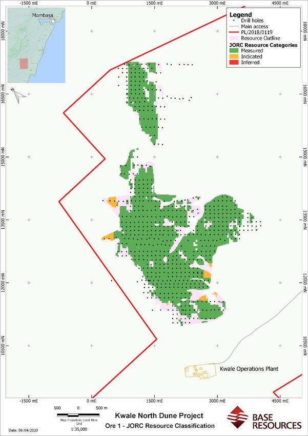
assessments for Ore Zones 1 and 5 which indicate increased ranges in the primary and/or secondary directions of grade continuity
compared to the 2019 Kwale North Dune Mineral Resources. The 2021 Kwale North Dune Mineral Resources estimate used a 1% HM
bottom cut because the economic cut-off grade at the nearby Kwale South Dune deposit mine is near to this, and resource estimates
for Kwale Operations have historically been reported at this cut-off grade. Figures 4, 6 and 7 show the distribution of the resource
classifications for Ore Zones 1, 4 and 5, respectively.

Further information specific to the 2021 Bumamani Mineral Resources estimate
The geological interpretations for the Bumamani deposit considered the data in the drill logs, HM assay results, microscopic logging of
HM sinks, detailed mineralogy and knowledge gained from mining the Central Dune and South Dune deposits. Three geological domains
have been identified at the Bumamani deposit. These were used and honoured during the geological modelling (Figure 8).

The uppermost zone at the Bumamani deposit, referred to as Ore Zone 1 (Figure 9), is a dark brown, predominantly fine grained, well
sorted silty sand with very little induration and is similar to the Ore Zone 1 units in the other Kwale deposits. It averages 1.9% HM, 21%
SL and 4% OS. The zone gets sandier to the east with reduced silt content. Mineralogically it is characterised by clean, glossy and
rounded HM grains with an average VHM content of approximately 70% VHM.

Ore Zone 4 (Figure 10) lies below Ore Zone 1, with the two zones separated by a lateritic paleo-surface which may imply a time-gap in
depositional history. Ore Zone 4 is a fluviatile unit represented locally with poorly sorted sandy clays and gritty sands. The Ore Zone 4
domain averages 1.8% HM, 23.6% SL and 6.4% OS. Ore Zone 4 is mineralogically similar to Ore Zone 1.

The Basement Zone at the Bumamani deposit lies beneath Ore Zone 4 and comprises compacted clays, sandy-clays, limestone and
fluvial sands. The grain sizes range from silt to pebbles and boulders, with generally poor sorting and is characterised by trace
concentrations of HM typically with low VHM content.

For Ore Zones 1 and 4, a strong correlation between the field logs, HM sink logs and XRF oxide chemistry and QEMSCAN mineralogy
gives confidence to these interpretations.

Drilling by Base Resources’ wholly-owned subsidiary, Base Titanium Limited, of the Bumamani deposit was completed using the RCAC
method and conducted in two campaigns in 2017 and 2018, both employing 76mm diameter, 3m long NQ drill rods. A total of 183
holes were drilled for 2,977.5m at 1.5m sampling intervals and generated 1,968 assayed samples. Holes were drilled 50m apart on
lines 100m apart. Samples were split using a rig mounted rotary splitter which delivered an average of 2.7kg of dry sample per interval.
Samples were dried, weighed, and screened for material less than 45µm (slimes) and +1mm (oversize).

Approximately 100 grams of the screened sample was subjected to a HM float/sink technique using the heavy liquid, lithium
polytungstate (LST) with a specific gravity of 2.85gcm-3. The resulting HM concentrate was dried and weighed as were the other
separated constituent size fractions (the minus 45µm material being calculated by difference).

Mineral assemblage analyses were conducted by Base Resources to characterise the mineralogical and chemical characteristics of
specific mineral species and magnetic fractions. These mineral assemblage samples were subjected to magnetic separation using a
Mineral Technologies induced-roll magnetic separator which captures mag, mid and non-mag fractions. The mid and mag fractions
were combined and, with the non-mag fraction, were subjected to XRF analysis using a Bruker, S8 Tiger XRF.

Data from the mag and non-mag XRF analyses was processed through the Minmod algorithm that runs approximately 100,000 iterations
in assigning key chemical species to derive a calculated mineralogy determination.

Drill hole collar and geology data was captured by industry-specific, field logging software with on-board validation. Field and assay
data were managed in a MS Access database and subsequently migrated to a more secure SQL database.

Standard samples were generated and certified for use in the field and laboratory. Accuracy of HM and SL analysis was verified by using
the standard samples and monitored using control charts. Standard errors greater than three standard deviations from the mean
prompted batch re-assay. A standard precision analysis was conducted on the key assay fields: HM, SL and OS for both laboratory and
field duplicate samples. Normal scatter and QQ plots were prepared for HM, SL and OS for laboratory and field duplicates.

A twin drilling program was introduced for the 2018 program to quantify short-range variability in geological character and grade
intersections. A water injection versus dry drilling assessment was included in the twin drilling analysis. Field and laboratory duplicate,
standard and twin drilling analysis show adequate level of accuracy and precision to support resource classifications as stated.

A topographic DTM was prepared by Base Resources based on a LIDAR survey.

                                                                                                                                Page 5 of 49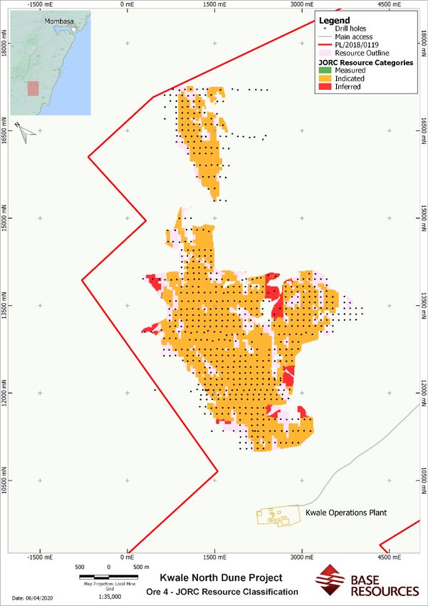
Construction of the geological grade model was based on coding model cells below open wireframe surfaces, comprising topography,
geology (Ore Zones 1 and 4) and basement (Figure 8). Model cell dimensions of 50m x 50m x 1.5m in the XYZ orientations were utilised.

Interpolation was undertaken using various sized search ellipses to populate the model with primary grade fields (HM, SL and OS), and
index fields (hardness, induration percent, mineralogy). Inverse distance weighting to a power of three was used for primary assay
fields whilst nearest neighbour was used to interpolate index fields. Figure 11 shows an oblique view of the model coloured by HM
grade.

A fixed bulk density of 1.7 (t/m3) was applied to the 2021 Bumamani Mineral Resources estimate model. This bulk density was selected
based on operational experience in the Kwale Central and South Dune deposits and because no bulk density sampling was undertaken.
This is considered to be a conservative estimate of bulk density.

The Bumamani deposit, being similar in nature to the Kwale South Dune deposit currently being mined, is considered amenable to
being mined and processed in the same way. That is, by using the existing plant and equipment at the Kwale Operations: hydraulic
mining, spiral concentrator and mineral separation plant with magnetic, electrostatic and further gravity separation. The only departure
from current methodology is that, for the Bumamani deposit (like for the Kwale North Dune deposit), the fine and coarse tailings are
likely to be co-disposed together. Apart from that, there is no indication that the mining, metallurgical and operating cost modifying
factors for the Bumamani deposit would be materially different to those derived from mining the Kwale South Dune deposit.

The criteria used for classification was primarily the drill spacing (predominantly 100m x 50m) and sample interval (1.5m), with
consideration also given to the continuity of mineral assemblage information. The ore zones exhibit spatially different classifications
mainly because of differing density of mineralogical information. The 2021 Bumamani Mineral Resources estimate used a 1% HM
bottom cut because the economic cut-off grade at the nearby Kwale South Dune deposit mine is near to this, and resource estimates
for Kwale Operations have historically been reported at this cut-off grade. Figures 9 and 10 show the distribution of the resource
classifications for Ore Zones 1 and 4 respectively.

Competent Persons' Statements
2021 Kwale North Dune Mineral Resources estimate

The information in this announcement that relates to the 2021 Kwale North Dune Mineral Resources estimate is based on, and fairly
represents, information and supporting documentation prepared by Mr. Greg Jones, who acts as a Consultant Geologist for Base
Resources and is employed by IHC Robbins. Mr. Jones is a Fellow of The Australasian Institute of Mining and Metallurgy and has
sufficient experience that is relevant to the style of mineralisation, type of deposits under consideration and activity which he is
undertaking to qualify as a Competent Person as defined in the JORC Code and as a Qualified Person for the purposes of the AIM Rules
for Companies. Mr. Jones has reviewed this announcement and consents to the inclusion in this announcement of the 2021 Kwale
North Dune Mineral Resources estimate and supporting information in the form and context in which that information appears.

2021 Bumamani Mineral Resources estimate

The information in this announcement that relates to the 2021 Bumamani Mineral Resources estimate is based on, and fairly represents,
information and supporting documentation prepared by Mr. Scott Carruthers. Mr. Carruthers is a Member of The Australasian Institute
of Mining and Metallurgy. Mr. Carruthers is employed by Base Resources, holds equity securities in Base Resources, and is entitled to
participate in Base Resources’ long-term incentive plan and receive equity securities under that plan. Details about that plan are
included in Base Resources’ 2020 Annual Report. Mr. Carruthers has sufficient experience that is relevant to the style of mineralisation,
type of deposits under consideration and activity which he is undertaking to qualify as a Competent Person as defined in the JORC Code
and as a Qualified Person for the purposes of the AIM Rules for Companies. Mr. Carruthers has reviewed this announcement and
consents to the inclusion in this announcement of the 2021 Bumamani Mineral Resources estimate and supporting information in the
form and context in which that information appears.

                                                                                                                              Page 6 of 49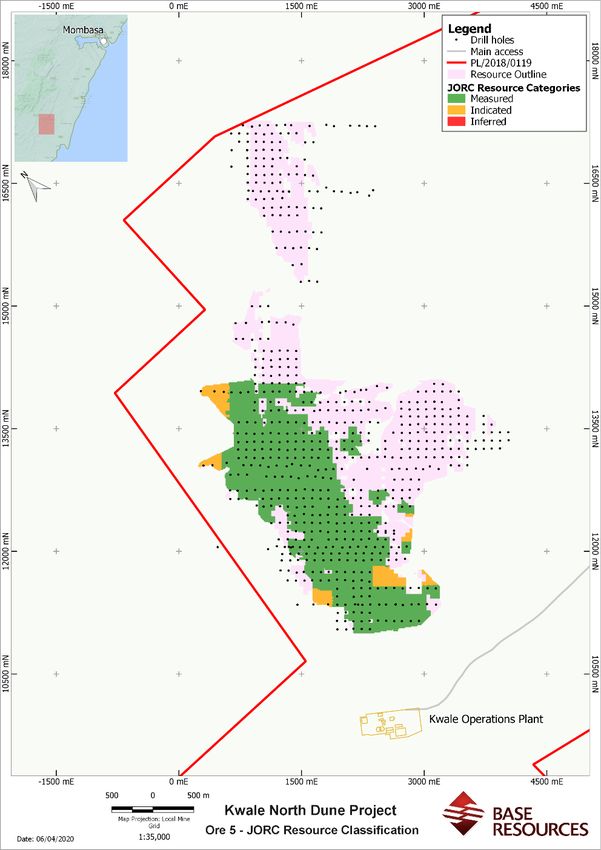
Forward Looking Statements
Certain statements in or in connection with this announcement contain or comprise forward looking statements.

By their nature, forward looking statements involve risk and uncertainty because they relate to events and depend on circumstances
that will occur in the future and may be outside Base Resources’ control. Accordingly, results could differ materially from those set out
in the forward-looking statements as a result of, among other factors, changes in economic and market conditions, success of business
and operating initiatives, changes in the regulatory environment and other government actions, fluctuations in product prices and
exchange rates and business and operational risk management. Subject to any continuing obligations under applicable law or relevant
stock exchange listing rules, Base Resources undertakes no obligation to update publicly or release any revisions to these forward-
looking statements to reflect events or circumstances after the date of this announcement or to reflect the occurrence of unanticipated
events.

No representation or warranty, express or implied, is made as to the fairness, accuracy or completeness of the information contained
in this announcement (or any associated presentation, information or matters). To the maximum extent permitted by law, Base
Resources and its related bodies corporate and affiliates, and their respective directors, officers, employees, agents and advisers,
disclaim any liability (including, without limitation, any liability arising from fault, negligence or negligent misstatement) for any direct
or indirect loss or damage arising from any use or reliance on this announcement or its contents, including any error or omission from,
or otherwise in connection with, it.

Nothing in this announcement constitutes investment, legal or other advice. You must not act on the basis of any matter contained in
this announcement but must make your own independent investigation and assessment of Base Resources and obtain any professional
advice you require before making any investment decision based on your investment objectives and financial circumstances. This
announcement does not constitute an offer, invitation, solicitation, advice or recommendation with respect to the issue, purchase or
sale of any security in any jurisdiction.

                                                                                                                                  Page 7 of 49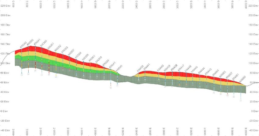
Figure 1: Wider Kwale location showing the South Dune, North Dune and Bumamani deposits, and the Kwale Central sand tails area.

                                                                                                                       Page 8 of 49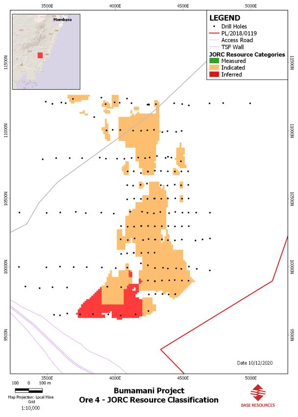
Figure 2: Plan showing concentrations of heavy minerals at Kwale Operations.

Figure 3: Schematic cross-section of the Kwale North Dune deposit showing geology relationships between geological domains.

                                                                                                                        Page 9 of 49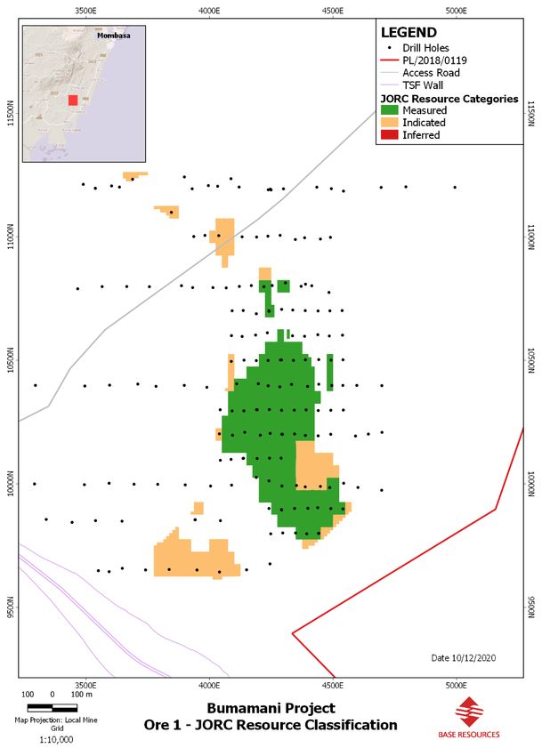
Figure 4: Map showing Kwale North Dune deposit, location of drill holes, tenure boundaries and Resources category for Ore Zone 1.

                                                                                                                       Page 10 of 49
Figure 5: Oblique view of Kwale North with model cells coloured on HM grade.
Page 11 of 49Figure 6: Map showing Kwale North Dune deposit, location of drill holes, tenure boundaries and Resources category for Ore Zone 4.
Page 12 of 49Figure 7: Map showing Kwale North Dune deposit, location of drill holes, tenure boundaries and Resources category for Ore Zone 5.
Page 13 of 49Figure 8: Schematic cross-section of the Bumamani deposit showing geology relationships between geological domains.
Page 14 of 49Figure 9: Map showing Bumamani deposit, location of drill holes, tenure boundaries and Resources category for Ore Zone 1.
Page 15 of 49Figure 10: Map showing Bumamani deposit, location of drill holes, tenure boundaries and Resources category for Ore Zone 4.
Page 16 of 49Figure 11: Bumamani deposit oblique view with model cells coloured on HM grade.
Page 17 of 49Appendix 1 – 2021 Kwale North Dune Mineral Resources estimate
JORC Code, 2012 Edition
Section 1 Sampling Techniques and Data
(Criteria in this section apply to all succeeding sections.)
Criteria Explanation Comment
Sampling Nature and quality of sampling (e.g., cut channels, random chips, Reverse circulation aircore drilling was used to collect downhole samples for the project.
techniques or specific specialised industry standard measurement tools
Of the 745 drill holes used for this resource update, 21 of them (drilled between 2010 – mid 2012)
appropriate to the minerals under investigation, such as down
utilised 3m sample intervals. The remaining 724 drill holes used 1.5m sample intervals from mid-
hole gamma sondes, or handheld XRF instruments, etc). These
2012 to 2019 using an on-board rotary splitter mounted beneath the rig cyclone.
examples should not be taken as limiting the broad meaning of
sampling. Sample gates were set to collect 25% of the splitter cycle, which delivered about 2.5 - 3.5kg of
sample per interval on average.
Include reference to measures taken to ensure sample
representivity and the appropriate calibration of any Duplicate samples were collected at the splitter for every 20th sample simultaneously with the
measurement tools or systems used. original sample.
Aspects of the determination of mineralisation that are Material A representative grab sample from the sample bags was routinely washed and panned for a visual
to the Public Report. In cases where ‘industry standard’ work has HM content estimate.
been done this would be relatively simple (e.g., ‘reverse circulation
drilling was used to obtain 1 m samples from which 3 kg was
pulverised to produce a 30 g charge for fire assay’). In other cases,
more explanation may be required, such as where there is coarse
gold that has inherent sampling problems. Unusual commodities
or mineralisation types (e.g., submarine nodules) may warrant
disclosure of detailed information.
Drilling techniques Drill type (e.g., core, reverse circulation, open-hole hammer, 122 holes in the 2010, 2012/2013 campaigns were drilled with a RCAC Wallis Mantis 75 drill rig
rotary air blast, auger, Bangka, sonic, etc) and details (e.g., core using NQ drill tooling of about 76mm in diameter.
diameter, triple or standard tube, depth of diamond tails, face-
567 holes in the 2018 campaign and the 56 holes in the 2019 campaign were drilled with a more
sampling bit or other type, whether core is oriented and if so, by
modernised Mantis 80 drill rig, also using NQ drill bits.
what method, etc).
For the 2010 and 2012/13 campaigns, the mast was oriented vertically (90º) by sight. For the
2018/19 drilling campaign, the rig mast was orientated vertically by spirit level prior to drilling to
adhere to best practice for geological boundary delineation.
Drilling was recorded in geological logs as either dry or water injected, depending on ground
Page 18 of 49Criteria Explanation Comment
conditions. Water injection was employed to assist with penetration through clays/rock and
maintain sample quality and delivery.
Drill sample Method of recording and assessing core and chip sample Sample condition was logged at the rig as either good, moderate or poor, with good meaning not
recovery recoveries and results assessed. contaminated and appropriate sample size (recovery), moderate meaning not contaminated, but
sample over or under sized, and poor meaning contaminated or grossly over/undersized.
Measures taken to maximise sample recovery and ensure
representative nature of the samples. Slightly damp ground conditions with approximately 36% silt/clay meant that best sample quality
was found to be achieved via slow penetration with water injection to aid in the sample recovery.
Whether a relationship exists between sample recovery and grade
and whether sample bias may have occurred due to preferential No relationship is believed to exist between grade and sample recovery. No bias is also believed to
loss/gain of fine/coarse material. occur due to loss of fine material.
Logging Whether core and chip samples have been geologically and Field logging was recorded for all 16,257 fixed, down-hole intervals and was conducted as drilling
geotechnically logged to a level of detail to support appropriate and sampling proceeded. Logging was based on a representative grab sample that was panned for
Mineral Resource estimation, mining studies and metallurgical heavy mineral estimation and host material observations.
studies.
Logging codes were designed to capture observations on lithology, colour, grainsize, induration and
Whether logging is qualitative or quantitative in nature. Core (or estimated mineralisation. Any relevant comments e.g., water table, gangue HM components and
costean, channel, etc) photography. stratigraphic markers were included to aid in the subsequent geological modelling.
The total length and percentage of the relevant intersections A qualitative estimate of how representative a sample was of the drilled interval was recorded by
logged. Base Titanium Limited (BTL) field geologists whilst logging. This sample condition field records
whether the hole was drilled with injected water or dry and sample size (and the influence of
contamination or sample loss) directs the quality assessment of each sample.
Heavy mineral sinks from assayed samples were logged routinely under a reflected-light,
stereoscopic microscope. This work was carried out to capture information relating to VHM
content, mineralogy, HM grainsize and quality.
Page 19 of 49Criteria Explanation Comment
Sub-sampling If core, whether cut or sawn and whether quarter, half or all core Rotary split at the sampling cyclone on the rig. Approximately 25% of the original sample retained.
techniques and taken. Duplicate samples were collected at every 20th sample. The drill rods and cyclone were routinely
sample preparation cleaned between holes using pressurised water to avoid inter-hole contamination. The sample size
If non-core, whether riffled, tube sampled, rotary split, etc and
is considered appropriate for the grain size of the material because the grade of HM is measured in
whether sampled wet or dry.
per cent, and a 2.5-5kg sample contains in excess of 50 million grains of sand.
For all sample types, the nature, quality and appropriateness of
The sample preparation flow sheet departed from standard mineral sand practices in one respect;
the sample preparation technique.
the samples were not oven dried prior to de-sliming, to prevent clay minerals being baked onto the
Quality control procedures adopted for all sub-sampling stages to HM grains (because the HM fractions were to be used in further mineralogical test work). Instead,
maximise representivity of samples. a separate sample was split and dried to determine moisture content, which was accounted for
Measures taken to ensure that the sampling is representative of mathematically.
the in-situ material collected, including for instance results for Pre-soaking of the sample Sodium (Tetra) Pyrophosphate (TSPP) dispersant solution ensured a
field duplicate/second-half sampling. more efficient de-sliming process and to avoid potentially under-reporting slimes content.
Whether sample sizes are appropriate to the grain size of the
material being sampled.
Quality of assay The nature, quality and appropriateness of the assaying and The assay process employed included a Sample Preparation stage, completed by BTL staff, followed
data and laboratory laboratory procedures used and whether the technique is by a heavy liquid separation (using lithium polytungstate: SG = 2.85g/cm3), completed at Kwale
tests considered partial or total. Operations’ site laboratory.
For geophysical tools, spectrometers, handheld XRF instruments, Improvements to the sample preparation stage were made to ensure industry best practice and to
etc, the parameters used in determining the analysis including deliver a high degree of confidence in the results. These included the following:
instrument make and model, reading times, calibrations factors
• A formalised process flow was generated, posted in all sample preparation areas and used to
applied and their derivation, etc.
train and monitor sample preparation staff
Nature of quality control procedures adopted (e.g., standards,
• Regular monitoring was completed by BTL senior staff
blanks, duplicates, external laboratory checks) and whether
acceptable levels of accuracy (i.e., lack of bias) and precision have • Field samples were left in their bags for initial air-drying to avoid sample loss
been established.
• TSPP was introduced to decrease attrition time and improve slimes recovery. A range of
attrition times (with 5% TSPP) were trialled and plotted against slimes recovery figures to
determine optimum attrition time (15 minutes)
• Staff were trained to use paint brushes and water spray rather than manipulate sample
through slimes screen by hand to remove the potential for screen damage
Page 20 of 49Criteria Explanation Comment
• A calibration schedule was introduced for scales used in the sample preparation stage
• The introduction of ruggedized computers allowed the capture of sample preparation data
digitally at inception. This greatly reduced the instance of scribe and data entry errors
• Slimes screen number recorded to isolate batches should re-assay be required due to poor
adherence to procedure or to identify screen damage
• Various quality control samples were submitted routinely to assure assay quality. A total of 809
duplicate field samples, 809 lab duplicate sample preparation samples, 279 field certified
standard samples, and an unspecified number of internal laboratory standards, repeats and
blanks have been assayed at Kwale Operations’ site laboratory.
Verification of The verification of significant intersections by either independent The Kwale North Dune deposit is a moderate to low HM grade, dunal-style accumulation that does
sampling and or alternative company personnel. not carry excessive mineralisation or suffer from ‘nugget’ effects, typical of other commodities.
assaying
The use of twinned holes. No external audit validation was completed for the HM analyses included in the 2021 Kwale North
Dune Mineral Resources estimate. This is not considered material given the adequate performance
Documentation of primary data, data entry procedures, data
of results from extensive QA/QC verification and on account of low HM grade variance and deposit
verification, data storage (physical and electronic) protocols.
homogeneity.
Discuss any adjustment to assay data.
A twin drill hole procedure was introduced for the 2018/19 program at a recommended rate of 5%
of the total number of holes. These twins were used to quantify short-range variability in
geological character and grade intersections and ideally should be placed throughout the deposit.
A total of 41 twin drill holes were completed during the 2018/19 Kwale North Dune drilling
program, which represents about 5.7% of the total program.
The spatially well-represented twin hole paired data shows very good correlation considered
material to the integrity/quality of the resource data.
Page 21 of 49Criteria Explanation Comment
Location of data Accuracy and quality of surveys used to locate drill holes (collar Proposed drill holes were sited on the ground using hand-held GPS. After drilling, surveyors
points and down-hole surveys), trenches, mine workings and other recorded collar positions via DGPS RTK unit registered to local base stations. The accuracy of the
locations used in Mineral Resource estimation. DGPS unit is stated at 0.02m in the X, Y and Z axes.
Specification of the grid system used. The survey Geodetic datum utilised was UTM Arc 1960, used in E. Africa. Arc 1960 references the
Clark 1880 (RGS) ellipsoid and the Greenwich prime meridian. All survey data used in the 2021
Quality and adequacy of topographic control.
Kwale North Mineral Resources estimate dataset has undergone a transformation to the local mine
grid from the standard UTM Zone 37S (Arc 1960). The local Grid was rotated 42.5o, which aligns the
average strike of the deposit with local North and is useful for both grade interpolation and mining
reference during production.
All drill collars were projected to the local LIDAR survey, digital terrain model, captured over the
resource area in 2018/19 at a 2x2m grid spacing. This was performed prior to interpretation and
model construction to eliminate any elevation disparities for the block model construction.
Data spacing and Data spacing for reporting of Exploration Results. The drill data spacing for the 2018/19 Kwale North Resource drilling was nominally 100m X, 100m Y
distribution and 1.5m Z. Variations from this spacing resulted from terrain/traverse difficulties and ground
Whether the data spacing, and distribution is sufficient to
access.
establish the degree of geological and grade continuity
appropriate for the Mineral Resource and Ore Reserve estimation A sample spacing of 3m, with occasional 1.5m intervals at geological contacts, was employed in the
procedure(s) and classifications applied. 2012/2013 drilling campaign by BTL.
Whether sample compositing has been applied. A 3m, down-hole block size was applied to model construction and for consistency in the
interpolation processes.
This spacing and distribution is considered sufficient to establish the degree of geological and
mineralisation continuity appropriate for the resource estimation procedures and classifications
applied.
No sample compositing has been applied for HM, slimes and oversize in the interpolation
processes.
Orientation of data Whether the orientation of sampling achieves unbiased sampling With the geological setting being a layered dunal/fluviatile sequence, the orientation of the deposit
in relation to of possible structures and the extent to which this is known, mineralisation in general is sub-horizontal. All drill holes were orientated vertically to penetrate the
geological structure considering the deposit type. sub-horizontal mineralisation orthogonally.
If the relationship between the drilling orientation and the Hole centres were spaced nominally at 100m. This cross-profiles the dune so that variation can be
orientation of key mineralised structures is considered to have determined. Down hole intervals were nominated as 1.5m. This provides adequate sampling
resolution to capture the distribution and variability of geology units and mineralisation
Page 22 of 49Criteria Explanation Comment
introduced a sampling bias, this should be assessed and reported encountered vertically down hole.
if material.
The orientation of the drilling is considered appropriate for testing the horizontal and vertical
extent of mineralisation without bias.
Sample security The measures taken to ensure sample security. Sample residues from the prep stage were transferred to pallets and stored in a locked shed beside
the warehouse at Kwale Operations.
Residues from the Kwale Operations site laboratory were placed in labelled bags and stored in
numbered boxes. Boxes were placed into a locked container beside the laboratory.
Sample tables are housed on a secure, network-hosted SQL database. Administration privileges are
limited to two BTL staff: Exploration Superintendent and the Business Applications Administrator.
Data is backed up every 12 hours and stored in perpetuity on a secure, site backup server.
Audits or reviews The results of any audits or reviews of sampling techniques and In-house reviews were undertaken by the Base Resources’ Resources Manager, Mr. Scott
data. Carruthers who is a Competent Person under the JORC Code.
Page 23 of 49Section 2 Reporting of Exploration Results
(Criteria listed in the preceding section also apply to this section.)
Criteria Explanation Comment
Mineral tenement Type, reference name/number, location and ownership including The Kwale North Dune is situated on a Prospecting License (PL) 100% owned by Base Titanium
and land tenure agreements or material issues with third parties such as joint Limited – PL/2018/0119 located in Kwale County, Kenya. Base Titanium Limited is a wholly owned
status ventures, partnerships, overriding royalties, native title interests, subsidiary of Australian and UK-listed resources company, Base Resources Limited.
historical sites, wilderness or national park and environmental
The 88.7 km2 Prospecting License was granted on the 26th of May 2018 for a three-year term
settings.
ending 25th May 2021.
The security of the tenure held at the time of reporting along with
The PL is in good standing with the Kenya Ministry of Petroleum & Mining at the time of reporting,
any known impediments to obtaining a licence to operate in the
with all statutory reporting and payments up to date.
area.
Local landowners generally supportive of exploration activities with over 90% of planned holes
drilled.
The existing Special Mining Lease 23 lies within the Prospecting license area and covers the Kwale
Central Dune deposit and some of the Kwale South Dune deposit but does not include the Kwale
North Dune deposit. The Kenya Mining Act 2016 includes provision for the amendment of an
existing SML and for the conversion of an existing PL to SML.
Exploration done by Acknowledgment and appraisal of exploration by other parties. In 1996, Tiomin carried out reconnaissance surface and hand-auger sampling.
other parties
Following the encouraging results obtained, mud-rotary drilling was undertaken in 1997 and 37
holes for a total of 1,824m was achieved for the North dune, at 3m sampling intervals.
Prior to acquisition of the Kwale Project by Base Resources, Tiomin prepared and published a North
Dune Mineral Resources estimate of 116 Mt @ 2.1% HM using a 0.5% HM cut-off grade.
The current resource model omits the Tiomin data. This followed a twin drilling analysis of the
Tiomin Mud Rotary holes with Base Resources’ RCAC to determine relevance of historical data to
the Kwale South Dune Mineral Resources estimate in 2016. A total of 18 twin-hole pairs from a
geographically dispersed area within the South Dune were included for analysis. A very poor
correlation in HM values between the two methods (R2 = 0.1522) resulted from the study. It is
assumed that the poor correlation would extend to the North Dune.
This is expected, given the open-hole method of drilling employed by Tiomin and supports the
decision to exclude Tiomin data from the current interpolation.
Page 24 of 49Criteria Explanation Comment
Geology Deposit type, geological setting and style of mineralisation. The North Dune is part of the extensive Kwale Dune systems comprising of reddish, windblown
Magarini sand formations that overlie a sequence of mineralised clay-rich fluviatile units, which in
turn overlie a Mesozoic sandstone Base, known as the Mazeras formation.
These three units are separated by lateritic paleo-surfaces which signify a time-gap between the
geological formations.
The Mazeras Sandstone, derived from the disintegration of the Mozambique Belt metamorphic
rocks, has likely provided the supply of heavy minerals to the Magarini sand dunes and the fluviatile
formations.
Exploration of the Kenyan coastline is yet to be successful in terms of mineralised paleo-strandlines
related to fossil marine terraces, as these are likely buried beneath recent barren fluvial
overburden or were just not developed owing to reduced energy levels from a fringing coral reef
that has acted as a barrier to effective winnowing and reworking of HM deposits.
Drill hole A summary of all information material to the understanding of the Drilling by year (max, min and average depths) used for the resource model build are as follows:
Information exploration results including a tabulation of the following
• 2010
information for all Material drill holes:
o 11 drill holes (depth: max 72m, min 24m, avg 56m).
• easting and northing of the drill hole collar o Total 582m drilled.
• elevation or RL (Reduced Level – elevation above sea level in
• 2012
metres) of the drill hole collar
o 31 drill holes (depth: max 75m, min 18m, avg 60m).
• dip and azimuth of the hole
o Total 1,681.5m drilled.
• down hole length and interception depth
• hole length. • 2013
o 80 drill holes (depth: max 75m, min 27m, avg 55m).
If the exclusion of this information is justified on the basis that the
o Total 3,792m drilled.
information is not Material and this exclusion does not detract
from the understanding of the report, the Competent Person • 2018
should clearly explain why this is the case. o 567 drill holes (depth: max 117m, min 6m, avg 45 m).
o Total 20,477m drilled.
• 2019
o 56 drill holes (depth: max 30m, min 9m, avg 30m).
o Total 897m drilled.
See drill hole location plan, Figure 4.
Page 25 of 49Criteria Explanation Comment
All drill holes drilled vertically.
Exploration results are not being reported at this time.
Data aggregation In reporting Exploration Results, weighting averaging techniques, Exploration results are not being reported at this time.
methods maximum and/or minimum grade truncations (e.g., cutting of
No equivalent values were used.
high grades) and cut-off grades are usually Material and should
be stated. No aggregation of short length samples used as samples were consistently 3m and 1.5m intervals.
Where aggregate intercepts incorporate short lengths of high-
grade results and longer lengths of low-grade results, the
procedure used for such aggregation should be stated and some
typical examples of such aggregations should be shown in detail.
The assumptions used for any reporting of metal equivalent values
should be clearly stated.
Relationship These relationships are particularly important in the reporting of The deposit sequences are sub-horizontal, and the vertically inclined holes are a fair representation
between Exploration Results. of true thickness.
mineralisation
If the geometry of the mineralisation with respect to the drill hole
widths and
angle is known, its nature should be reported.
intercept lengths
If it is not known and only the down hole lengths are reported,
there should be a clear statement to this effect (e.g., ‘down hole
length, true width not known’).
Diagrams Appropriate maps and sections (with scales) and tabulations of See figures 3-7.
intercepts should be included for any significant discovery being
reported These should include, but not be limited to a plan view of
drill hole collar locations and appropriate sectional views.
Balanced reporting Where comprehensive reporting of all Exploration Results is not Exploration results are not being reported at this time.
practicable, representative reporting of both low and high grades
and/or widths should be practiced to avoid misleading reporting
of Exploration Results.
Page 26 of 49Criteria Explanation Comment
Other substantive Other exploration data, if meaningful and material, should be The proprietary Minmod mineralogy technique, developed and employed by Base Resources,
exploration data reported including (but not limited to): geological observations; comprises an XRF analysis of the magnetic and non-magnetic fractions of each composite or
geophysical survey results; geochemical survey results; bulk sample, the results from which are then back-calculated to determine in-ground mineralogy.
samples – size and method of treatment; metallurgical test Minmod represents an improvement on the previous method (Geomod) that was not as effective
results; bulk density, groundwater, geotechnical and rock at determining accessory minerals in the Kwale assemblage. Minmod has been validated by
characteristics; potential deleterious or contaminating substances. external quantitative analysis (QEMSCAN and SEM EDX) and is considered sufficiently certified to
support quoted resource confidence in this report.
Further work The nature and scale of planned further work (e.g., tests for Additional 100 x 100m aircore drilling to in-fill gaps and extend mineralisation in the open NW part
lateral extensions or depth extensions or large-scale step-out of the deposit.
drilling).
Recommended 50 x 50m aircore drilling across strike primarily to improve across strike variography
Diagrams clearly highlighting the areas of possible extensions, for Ore 4.
including the main geological interpretations and future drilling
Generation of further Ore Zone 5 QEMSCAN composites for a more confident mineralogical
areas, provided this information is not commercially sensitive.
modelling.
Detailed tests to establish accurate bulk densities.
Page 27 of 49Section 3 Estimation and Reporting of Mineral Resources
(Criteria listed in section 1, and where relevant in section 2, also apply to this section.)
Criteria Explanation Comment
Database integrity Measures taken to ensure that data has not been corrupted by, Field data was captured in LogChief logging application and automatically validated through
for example, transcription or keying errors, between its initial reference to pre-set library table configurations.
collection and its use for Mineral Resource estimation purposes.
Typing or logging code errors, duplication of key identifiers (e.g., HOLE_ID, SAMP_ID) and conflicts in
Data validation procedures used. related tables (e.g., down-hole depth) are quarantined by the software and require resolving
immediately before logging can proceed.
The SQL Database also has identical automated validation features. Data import is unsuccessful until
these data issues are resolved.
Field logging and survey data from the SQL database were imported into Datamine Discover
(MapInfo) for sectional interpretation.
Validation steps included a visual interrogation of collar versus geology depths, a review of hole
locations against the drilling plan and a check for missing or duplicated logged fields and outliers.
Any spurious or questionable entries were resolved by the supervising Geologist.
At the completion of each hole, an entry was made to the hand-written drilling diary. The diary
recorded the hole name, date, depth, number of samples, time of start and finish, a description of
the location of the hole in relation to the last hole and other things. Such a diary provides valuable
evidence if there is an error in hole naming or surveying.
A geologist was employed to manage digital data capture at the sample preparation laboratory to
reduce the potential for data entry error by unskilled labourers. A number of validation checks were
made of sample preparation data to ensure accurate data entry and application of correct procedure
by BTL staff. This included:
• comparison of pre- versus post-oven weights
• comparison of split weight versus de-slimed weight
• comparison of split weight versus field sample weight
• all sample preparation data were sorted by each individual field and outliers investigated
Assay results were delivered via email in 45 sample batches from Kwale Operations’ site laboratory.
These were in the form of CSV text files and imported by batch number directly into the SQL
Page 28 of 49Criteria Explanation Comment
database tables where pre-set algorithms converted weights to percentages and removed the
moisture content. The calculated assay results were then checked manually for missing records and
out of range or unrealistic values.
Site visits Comment on any site visits undertaken by the Competent Person Base Resources’ Resources Manager Scott Carruthers made one site visit to review the SQL database
and the outcome of those visits. and the geological interpretations. The Competent Person is satisfied with the integrity of the
database as well as the delineation of the geological boundaries.
If no site visits have been undertaken indicate why this is the
case.
Geological Confidence in (or conversely, the uncertainty of) the geological The geological interpretation was undertaken by the BTL Exploration Superintendent using field logs
interpretation interpretation of the mineral deposit. and observations, assays, HM sachet logs, XRF oxide chemistry and mineralogy data. The oversize
grades were particularly useful in determining the lateritic paleo-surfaces between the geological
Nature of the data used and of any assumptions made.
zones.
The effect, if any, of alternative interpretations on Mineral
The data spacing for the project is considered sufficient for grade and mineralogical continuity.
Resource estimation.
Four mineralised geological zones and a basement zone were identified and are used as constraints
The use of geology in guiding and controlling Mineral Resource
in the Mineral Resources estimation.
estimation.
The uppermost zone at Kwale North, referred to as Ore Zone 1, is a dark brown, predominantly fine
The factors affecting continuity both of grade and geology.
grained, well sorted silty sand with very little induration. It is also characterised by a clean, high
value heavy mineral assemblage.
Ore Zone 4 lies below Ore Zone 1 with a clear lateritic boundary observed in the field with slightly
difficult bit penetration, and in HM sink logs, exhibiting elevated iron oxides. Ore Zone 4 is lower in
valuable heavy mineral content, often dominated by iron oxides and Al2SiO4 polymorphs (kyanite,
andalusite and sillimanite). It is considered a fluvial deposit based on the difficulty of wash and the
poor grain sorting.
Ore Zone 5 lies below Ore Zone 4 and is separated from that zone by a lateritic paleo-surface. It is
unique mineralogically due to an increased amount of almandine garnet that reports to the mag
fraction, significantly increasing the magnesium, manganese, aluminium and silicon in the oxide
chemistry, and this is also reflected in QEMSCAN mineralogy.
For Ore Zones 1, 4 and 5, a strong correlation between the field logs, HM sink logs and XRF oxide
chemistry and QEMSCAN mineralogy gives confidence to these interpretations.
The grade and mineralogy continuity is abruptly truncated at the western edge by an interpreted
Page 29 of 49You can also read