URBAN REDEVELOPMENT PLAN CHAMBLEE URA 2018 - August 21, 2018 - Laura Linman
←
→
Page content transcription
If your browser does not render page correctly, please read the page content below

URBAN REDEVELOPMENT
PLAN CHAMBLEE URA 2018
        August 21, 2018

            Laura Linman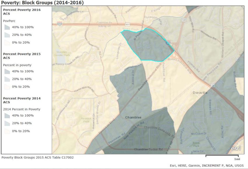
Table of Contents
Introduction ................................................................................................................................ 1
Boundaries of the URA .............................................................................................................. 1
Consistency with Adopted Plans ............................................................................................... 1
Description of Urban Redevelopment Areas.............................................................................. 2
Photographic Evidence ............................................................................................................ 14
Land Use Objectives ............................................................................................................... 19
Plan Impacts ............................................................................................................................ 19
Project Specifics ...................................................................................................................... 20

 City of Chamblee|2018                                                                          Urban Redevelopment Plan | i

Introduction
This City of Chamblee Urban Redevelopment Plan (this “Plan”) shall constitute an Urban
Redevelopment Plan for the City of Chamblee, Georgia (the “City of Chamblee” or “City”) within
the meaning of the “Urban Redevelopment Law,” Title 36, Chapter 61 of the Official Code of
Georgia Annotated, as amended. This Plan meets the requirements of O.C.G.A § 36-61- 2(24).
This Plan conforms to the general plan for the City as a whole. In the case of four of the urban
redevelopment areas, this Plan describes the City’s strategies and tactics for potential land
acquisitions, demolitions, redevelopments, improvements, and rehabilitations as may be
proposed in urban redevelopment areas. In the case of one of the urban redevelopment areas,
this Plan describes the actual land acquisitions, demolitions, redevelopments, improvements,
and rehabilitations. This Plan further considers zoning and planning changes, land use issues,
maximum densities, building and development requirements, and the plan's relationship to City
goals regarding suitable land uses, improved traffic and public transportation, the provision of
public utilities, the creation or expansion of recreational and community facilities, and other
public improvements in identified urban redevelopment areas.
Boundaries of the URA
The urban redevelopment area (the “URA”) is made up of multiple separate areas, each of which
has been determined to be a “pocket of blight” (as defined in the Urban Redevelopment Law)
and each of which displays the presence of conditions or a combination of factors that
substantially impairs and arrests the sound growth of the City of Chamblee. For the purposes of
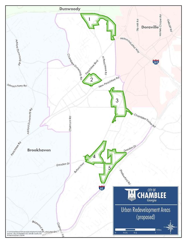
this plan, these areas are identified as Areas 1, 2, 3, 4, and 5 and are more fully defined below.
Consistency with Adopted Plans
Th is Plan is consistent with the Chamblee Comprehensive Plan, as adopted in 2015. The
Comprehensive Plan lists the following goals for the community:
1. Create a greater sense of community identity.
2. Support a thriving business environment.
3. Promote a healthy and safe living environment.
4. Develop and maintain strong multi-modal connections.
5. Provide quality government service through partnership and cooperation.
This Plan will assist in pursuing redevelopment projects and partnerships that will support all of
the above goals.
City of Chamblee|2018 Urban Redevelopment Plan | 1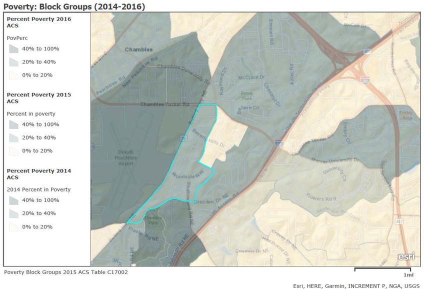
The City of Chamblee has completed several other plans that are helpful in providing context
for the redevelopment of the City.
   •   Economic Development Strategic Plan – Adopted in 2016, the EDSP provides
       strategies to increase overall wealth, raise property values, and add jobs to Chamblee.

   •   Downtown Chamblee Livable Centers Initiative Plan – Adopted in 2001 and updated in
       2007 and 2014, this plan was partially funded by the Atlanta Regional Commission and
       has helped to link transportation planning and land use decisions to create more a
       walkable and urban center.

   •   Buford Highway Livable Centers Initiative Plan – Adopted in 2017, this plan was also
       funded by the Atlanta Regional Commission in partnership with the City of Doraville.
       The Buford Highway LCI Plan will assist in improving the transportation infrastructure
       adjacent to Buford Highway, and offers ideas on refining the built environment along the
       corridor.

Description of Urban Redevelopment Areas
  •    URA 1 – Savoy Dr.
          o This area consists of a mix of commercial and residential properties along Savoy
             Drive and the frontage of Interstate 285. The area is approximately 136.19 acres
             and contains 120 parcels. The existing land uses are commercial businesses,
             multifamily homes, and single-family homes.

  •    URA 2 – Town Center
          o This area consists of warehouse, commercial, institutional, and vacant properties
             in the historic downtown core. City Hall, Chamblee Police Station, Chamblee Civic
             Center all feature prominently in this area. The area is approximately 56.33 acres
             and contains 47 parcels.

  •    URA 3 – Buford Highway/Chamblee Tucker
          o This area consists of commercial, residential, office, and institutional uses. The
             area is approximately 139.16 acres and contains 166 parcels. The area is
             dominated by Buford Highway and Chamblee Tucker Road,.

  •    URA 4 – Buford Highway/Dresden
          o This area consists of commercial, industrial, and residential uses and properties.
             The area is approximately 88.36 acres and contains 61 parcels. The City’s largest
             park, Dresden Park, is in this area

 City of Chamblee|2018                                         Urban Redevelopment Plan | 2
•   URA 5 – Shallowford Road
        o This area consists of commercial, industrial, institutional, and residential uses. The
           area is approximately 124.13 acres and contains 38 parcels. This area includes
           the Shallowford interchange as well as Johnson Road.

City of Chamblee|2018                                          Urban Redevelopment Plan | 3
City of Chamblee|2018 Urban Redevelopment Plan | 4
URA 1

City of Chamblee|2018   Urban Redevelopment Plan | 5

URA 2

City of Chamblee|2018   Urban Redevelopment Plan | 6

URA 3

City of Chamblee|2018   Urban Redevelopment Plan | 7

URA 4

City of Chamblee|2018   Urban Redevelopment Plan | 8
URA 5

City of Chamblee|2018   Urban Redevelopment Plan | 9
Negative conditions within the urban redevelopment areas
The URA has future economic potential, however it has been determined to be a pocket of blight
that contains: underutilized commercial land and structures; deteriorated or poorly maintained
housing stock; obsolescent buildings or facilities; visual blight; substandard public infrastructure,
including lack of sidewalks and pedestrian amenities, lighting, open space; inefficient street
layout; and fragmented, inappropriate or commercially nonviable subdivision platting or lot
layout; the high land to building value makes the properties located in the URA economically
viable for redevelopment.
In addition to the above, the URA includes many census block groups that have poverty rates
above 20% in 2016, as shown below.
URA 1

 City of Chamblee|2018                                           Urban Redevelopment Plan | 10
URA 2

City of Chamblee|2018   Urban Redevelopment Plan | 11
URA 3

City of Chamblee|2018   Urban Redevelopment Plan | 12
URA 4 & 5

City of Chamblee|2018   Urban Redevelopment Plan | 13
Photographic Evidence
URA 1

City of Chamblee|2018   Urban Redevelopment Plan | 14
URA 2

City of Chamblee|2018   Urban Redevelopment Plan | 15
URA 3

City of Chamblee|2018   Urban Redevelopment Plan | 16
URA 4

City of Chamblee|2018   Urban Redevelopment Plan | 17
URA 5

City of Chamblee|2018   Urban Redevelopment Plan | 18
Land Use Objectives
   •   Types of Uses
          o Land uses in each of the URAs will be a mixture of commercial, residential, and
              mixed-use. The existing allowable land uses in the URAs are diverse enough to
              permit a wide range of commercial and residential uses (see Zoning Map and list
              of zones in Appendix A).
   •   Building Requirements
          o The City of Chamblee will utilize the existing building requirements and life-safety
              regulations in the Unified Development Ordinance (UDO).
   •   Zoning Changes
          o Existing zoning classifications in the Chamblee UDO should be appropriate to drive
              redevelopment in each URA. If zoning changes are proposed to individual parcels,
              or as amendments the UDO, or Zoning Map, those changes will conform to
              O.C.G.A. Title 36 Chapter 66, known as “The Zoning Procedures Law.”
   •   Development Densities
          o No changes to existing development densities currently allowed in the Chamblee
              UDO are proposed in this Plan (see zoning dimension table in Appendix A).
   •   Description of Parcels to be Acquired.
          o The City does not anticipate acquiring any additional property at this time. In the
              future, the City or its designee may act to acquire one or more properties at
              which time this Plan will be amended.

Plan Impacts

Historic Preservation Considerations
The City of Chamblee values its local history and heritage, and this Plan seeks to preserve as
many historic structures and possible. No historic properties will be impacted by this Plan.
Strategy for Relocating Displaced Residents
The City has determined that the development of a relocation strategy is not necessary at this
time. In the event displacement of residents becomes necessary at a later date, this Plan will be
amended to incorporate a plan for relocating displaced residents in accordance with all local and
state statutory requirements.
Strategies for Access to Affordable Housing
Revitalization efforts in the Urban Redevelopment Area will focus on promoting mixed-use
development and redevelopment in Chamblee. The residential component of this development
should promote a variety of housing types, including units available to low- and moderate-income
residents.

 City of Chamblee|2018                                         Urban Redevelopment Plan | 19
Covenants and Restrictions to be Placed on Properties
No covenants or restrictions will be placed on properties at this time. Should circumstances arise
where making use of covenants and restrictions becomes necessary, this Plan will be amended.
Strategy for Leveraging Private Resources for Redevelopment
The purpose of this Plan is to encourage private redevelopment to the greatest extent possible.
Implementation of this Plan will focus on master planning efforts and funding mechanisms for
necessary public infrastructure to attract increased private development.
Public Infrastructure to be Provided
The City will work to provide the public infrastructure necessary to promote private
redevelopment in these areas. The City of Chamblee Capital Improvement Plan (CIP) will be a
guide for transportation enhancements – including sidewalks and transit – improved lighting,
streetscapes, public recreational space, and public parking in the URA. A copy of the Chamblee
CIP is incorporated in this Plan in Appendix B.
Project Specifics
The City has completed the Downtown Chamblee Town Center Plan, a master plan for URA 2
(“URA 2 Plan”). The specifics of URA 2 Plan are set forth below:
o URA 2 contains three city-owned buildings: City Hall, Police Department, and the
Civic Center. The police department will be moved to a new building in separate
location to relinquish the current land for a future 26,000-28,000 City Hall.
o The new City Hall will accommodate the services in the current Civic Center. Once
the new City Hall is built the Civic Center will be demolished and temporarily used
for surface parking until it can be assembled with nearby properties and sold to a
private developer.
o Broad Street is planned to be the central corridor and will be redeveloped with on-
street parking, 10-foot sidewalks, and regraded to either have a curbless or rolled
edge to allow for occasional pedestrian-only street closures for festivals.
o The current City Hall building will be adapted for a new public use.
o Once the new City Hall is built, a linear plaza/park space leading from the building to
Broad Street will provide public space for placemaking and outdoor events.
o The plan calls for the creation of an additional road on city-owned land to contribute
to a new street-grid system and to provide access to the new City Hall.
• Phase I – Master Planning
The City of Chamblee will begin a series of master planning exercises to determine the
appropriate levels of redevelopment in each area. Once complete, these master plans will
City of Chamblee|2018 Urban Redevelopment Plan | 20be incorporated into this Plan. Once the Plan is amended, the City, and private partners can address individual actions related to necessary entitlements to insure projects realize the greatest amount of private redevelopment activity. • Phase II – Stakeholder Outreach The City of Chamblee will use resources to contact property owners, businesses, and residents in the areas. Communication of the project’s goals and strategies with area stakeholders will greatly increase the probability of successful redevelopment. • Phase III – Infrastructure Planning The City of Chamblee will coordinate planned and new infrastructure projects to coincide with redevelopment projects that arise from the master planning and outreach phases. Analysis of existing and planned tax revenues will be performed to prioritize projects. City of Chamblee|2018 Urban Redevelopment Plan | 21
Appendix A

City of Chamblee|2018                Urban Redevelopment Plan | 22
City of Chamblee|2018 Urban Redevelopment Plan | 23
CHAPTER 210. - BASE ZONING DISTRICTS

Section 210-1. - Applicability.

This chapter sets forth the overall purpose and intent of each of the base zoning districts in the City of
Chamblee's Unified Development Ordinance (UDO). See additional standards pertinent to each property
as in Title 2 and 3.
Section 210-2. - NR-1, neighborhood residential 1 district.

Purpose and intent. This zoning district is intended primarily for single-family residences and related
accessory uses.

(Ord. No. 682 , pt. I, 6-16-15)

Section 210-3. - NR-2, neighborhood residential 2 district.

Purpose and intent. This zoning district is intended primarily for single-family residences and related
accessory uses at a higher density than NR-1.

(Ord. No. 682 , pt. I, 6-16-15)

Section 210-4. - NR-3, neighborhood infill district.

Purpose and intent. This zoning district is intended to provide standards for a specific infill development
plan that would apply to an existing lot or series of contiguous lots within or adjacent to an existing
neighborhood that would allow innovative use of the property.

(Ord. No. 682 , pt. I, 6-16-15)

Section 210-5. - VR, village residential district.

Purpose and intent. This zoning district is intended primarily for single-family attached and detached
residences, two-family residences, and multifamily residences with related accessory uses, supportive
nonresidential uses, open space, and amenities.

(Ord. No. 682 , pt. I, 6-16-15)

Section 210-6. - NC-1, low-density neighborhood commercial district.

Purpose and intent. This zoning district is intended primarily for a mixture of residential and nonresidential
development and related accessory uses at a low density and neighborhood scale. This district provides a
location for residences and convenient goods and services directly adjacent to single-family neighborhoods
that will satisfy the common and frequent needs of the residents of nearby residential neighborhoods.
Design standards and design parameters encourage a pedestrian-friendly traditional urban form, oriented
to pedestrians, which limits the conflicts between vehicles and pedestrians.

(Ord. No. 682 , pt. I, 6-16-15)

Section 210-7. - NC-2, medium-density neighborhood commercial district.

                                                                                                       Page 1
Purpose and intent. This zoning district is intended primarily for mixed-use development and related uses
at a medium density. This district provides a location for residences and convenient goods and services not
directly adjacent to single-family neighborhoods that will satisfy the common and frequent needs of the
residents of nearby residential neighborhoods. Design standards and design parameters encourage a
pedestrian-friendly traditional urban form, oriented to pedestrians, which limits the conflicts between
vehicles and pedestrians.
Section 210-8. - CC, corridor commercial district.
Purpose and intent. This zoning district is intended primarily for commercial and mixed-use development
and related accessory uses at a medium density. This district provides a location for residences, retail,
goods and services and offices to satisfy the common and frequent needs of the city's businesses and
residents. Design standards and design parameters encourage a pedestrian-friendly traditional urban form,
oriented to pedestrians, which limits the conflicts between vehicles and pedestrians.
(Ord. No. 682 , pt. I, 6-16-15)
Section 210-9. - CVC, corridor village commercial district.
Purpose and intent. This zoning district is intended primarily for nonresidential development and related
accessory uses at a medium density where auto-dominated uses are not appropriate. This district provides
a location for nonresidential uses in corridors of the city that serve the needs of the city's businesses and
residents. Design encourages a pedestrian-friendly traditional urban form, oriented to pedestrian, which
limits the conflicts between vehicles and pedestrians.
(Ord. No. 682 , pt. I, 6-16-15)
Section 210-10. - VC, village commercial district.
Purpose and intent. This zoning district is intended primarily for mixed-use development and related uses
at a higher density. This district provides a location for residences, retail, goods, services and offices to
satisfy the common and frequent needs of the city's commercial core and greater Chamblee area. Design
standards and design parameters encourage a pedestrian-friendly traditional urban form, oriented to
pedestrians, which limits the conflicts between vehicles and pedestrians.
(Ord. No. 682 , pt. I, 6-16-15)
Section 210-11. - TOD, transit oriented development district.
Purpose and intent. This zoning district is intended to support mixed-use development and higher density
development within walking distance of the Chamblee MARTA Station. This district provides a location for
residences, retail, goods and services and offices with design standards and design parameters to
encourage a pedestrian-friendly traditional urban form, oriented to a network of pedestrian and bicycle
pathways to the MARTA Station. This district is intended to minimize automobile use and maximize the use
of public transportation, bicycle and pedestrian access.
(Ord. No. 682 , pt. I, 6-16-15)
Page 2Section 210-12. - MU-BC, mixed-use - business center district.
Purpose and intent. The purpose and intent of this zoning district is to facilitate a high-rise urban form of
development with a mix of uses, open space, and a connected street and sidewalk system to support a
more active multi-modal and walkable environment at all times of the day. This district also encourages
adaptive reuse and redevelopment of existing mid-rise and high-rise development that was originally
designed in a suburban form.
The district shall consist of a minimum of two of the following use categories, which shall be accommodated
in a vertical mixed-use development configuration:
(a) Residential multifamily;
(b) Offices;
(c) Retail/Restaurant;
(d) Hotel; or
(e) Civic uses.
(Ord. No. 682 , pt. I, 6-16-15)
Section 210-13. - IT, industrial transitional district.
Purpose and intent. This zoning district is intended for adaptive reuse of properties in which low impact
industrial and commercial activities are permitted and where a transitional use is needed between
commercial and light industrial uses and less intense residential or commercial districts while maintaining
an attractive external environment.
(Ord. No. 682 , pt. I, 6-16-15)
Section 210-14. - I, light industrial district.
Purpose and intent. This zoning district is intended for properties that are located on or have ready access
to a major street or state highway and are well adapted to light industrial development but whose proximity
to residential or commercial districts makes it desirable to limit industrial operation and processes to those
that are not objectionable in terms of the emission of noise, vibration, smoke, dust, gas, fumes, odors and
do not create fire or explosion hazards, or other obnoxious conditions.
(Ord. No. 682 , pt. I, 6-16-15)
Page 3CHAPTER 230. - STANDARDS APPLYING TO ALL DISTRICTS
ARTICLE 1. - ZONING PROVISIONS
(Ord. No. 682 , pt. I, 6-16-15)
Section 230-1. - Dimensional standards of zoning districts.
(a) The following Space Dimensions Table states the space dimensions required for each lot in a zoning
district:
Space Dimensions Table 9
NC-2 MU-
NR-1 NR-2 NR-3 VR NC-1 1 1 CC CVC VC TOD IT I
BC
Total FAR
0.50 0.50 1.0 2.0 1.0 2.0 2.5 2.5 4.0 6.0 None 1.0 1.0
(max.)
Maximum
Impervious
Surface 45% 55% 60% 80% 80% 80% 80% 80% 80% 80% 80% 80% 60%
(% of lot
area) 3
Minimum
Open
Space (% N/A N/A 20% 20% 20% 20% 20% 20% 20% 20% 20% 20% N/A
of lot area)
2
Max
60' 60' 75'
building 34' 34' 38' 48' 48' 60' 90' none 60' 60'
height 3 , 8
Lot size
(min. in 8,000 6,000
None None None None None None None None None None None
square sf sf
feet)
Lot width
(min. in 55' 45' None None None None None None None None None none 100'
feet) 4
Front yard 20’ 20’ 20’ 10’ none none none none none none none none 10’
setback(min. in
feet) 5, 6
Street
Side yard
15’ 15’ 15’ 5’ none none none none none none none none none
(min. in
feet) 6, 7
Side yard
(min. in 7.5' 5' None None None None None None None None None 10' 10'
feet) 6,
Rear yard
(min. in 25' 20' 20' none none none none none none none none 20' 20'
feet)
(1) Single-family detached residential developments in NC-1/NC-2 shall follow the dimension
standards for NR-2.
(2) See also open space provision in Subsection 230-30.
(3) Additional height limitations are in place for any structure within the Runway Protection Zone, see
Section 220-1. In addition, any construction within five miles of the DeKalb Peachtree Airport is
subject to Title 14 of the Code of Federal Regulations (14 CFR) Part 77 and may require review by
the Federal Aviation Administration.
(4) Cul-de sac lots shall provide the minimum lot width at the front yard setback line. The lot width
shall not be measured from the discretionary placement of the principal structure.
(5) Front yard requirements for through lots. Buildings on through lots extending through from street
to street shall provide the required front yard on all streets.
(6) Detached houses constructed or renovated on a block face that is occupied by two or more
detached houses shall comply with Section 230-3, Contextual Lot and Building Standards for Infill
Development.
(7) Side yard requirements are variable in the NR-3, VR, NC-1, NC-2, CC, CVC, VC, TOD and MU-
BC, depending on the abutting zoning district; see Section Chapter 320, Article 2.
(8) See Section 230-5 for height exceptions.
(9) See Section 240-13(b)(1) for single-family attached (townhouse) dwelling dimensional standards.
(10) Residential front yards.
a. In single-family residential districts, the front yard shall be landscaped with the exception of driveways,
terraces, and walkways, which may occupy a maximum of one-half of the front yard area.
b. Automobile parking is only permitted in front yards when located on the permitted access driveway on
asphalt or gravel surface.
(b) Location and width of zoning buffers.
(1) The following Buffer Specification Table states the minimum buffer specifications required for
each zoning district.Appendix B City of Chamblee|2018 Urban Redevelopment Plan | 24
City of Chamblee Capital Improvement Program
                      Project                   Phase       Fund Source     2018        2019       2020        2021        2022      TOTALS
Pierce Drive Sidewalks (Chamblee HS to
                                               Design        HOST            $50,000     $0         $0          $0          $0       $50,000
Peachtree Blvd) Design & Construction
Peachtree Blvd Sidewalks (Johnson Ferry       Design &
                                                             HOST        $135,000        $0         $0          $0          $0      $135,000
to Clairmont Road) Design & Construction     Construction
Rail Trail Design                              Design        HOST        $158,253        $0         $0          $0          $0      $158,253
City Hall Renovation                         Construction    HOST        $180,000        $0         $0          $0          $0      $180,000
North Shallowford/New Peachtree Roundabout     Design        HOST        $200,000        $0         $0          $0          $0      $200,000
Park Improvement Program                         N/A         HOST      $621,216           $0        $0          $0          $0      $621,216
HOST                                                                  $1,344,469          $0        $0          $0          $0
Rail Trail Artwork/sculptures/amenities          N/A      Renaissance     $0            $50,000   $50,000     $50,000     $50,000   $200,000
MARTA Plaza & Mobility Hub                     Design     Renaissance $100,000            $0        $0          $0          $0      $100,000
Peachtree Road Streetscape Design              Design     Renaissance $180,000             0         0           0           0      $180,000
Renaissance                                                            $280,000        $50,000    $50,000     $50,000     $50,000
Keswick Park Bathrooms 2                       Design      Rental Veh     $0            $18,500     $0          $0          $0       $18,500
Keswick Park Bathrooms 2                     Construction Rental Veh      $0           $181,500     $0          $0          $0      $181,500
Keswick Park Bathrooms 1                     Construction Rental Veh   $150,000           $0        $0          $0          $0      $150,000
Rental Vehicle                                                         $150,000        $200,000     $0          $0          $0      $350,000
Pierce Drive Sidewalks (Chamblee HS to
                                             Construction   SPLOST             $0      $135,000     $0          $0          $0      $135,000
Peachtree Blvd) Design & Construction
                                              Design &
Admiral Drive Sidewalk Repair                               SPLOST             $0      $25,000      $0          $0          $0       $25,000
                                             Construction
North Shallowford/New Peachtree Roundabout   Construction   SPLOST             $0        $0         $0       $2,700,000     $0      $2,700,000
Peachtree Road Bridge @ Chamblee Dunwoody    Construction   SPLOST             $0        $0       $100,000      $0          $0      $100,000
Rail Trail Segment 1
                                             Construction   SPLOST             $0      $315,000     $0          $0          $0      $315,000
(Existing Rail Trail to Peachtree Rd)
Rail Trail Segment 4
                                             Construction   SPLOST             $0      $290,000     $0          $0          $0      $290,000
(Chamblee Tucker Rd to Malone Dr)
Rail Trail Segment 5
                                             Construction   SPLOST             $0        $0       $455,000      $0          $0      $455,000
(Malone Dr to Miller Dr)
Rail Trail Segment 6
                                             Construction   SPLOST             $0        $0       $225,000      $0          $0      $225,000
(Miller Dr to Pierce Dr)

                                                                    Page 1
City of Chamblee Capital Improvement Program
Project Phase Fund Source 2018 2019 2020 2021 2022 TOTALS
Peachtree Road Streetscape Phase 1
Construction SPLOST $0 $1,600,000 $0 $0 $0 $1,600,000
(McGaw Dr to Pierce Dr)
Peachtree Road Streetscape Phase 2
Construction SPLOST $0 $300,477 $0 $0 $0 $300,477
(Pierce Dr to Chamblee Dunwoody Rd)
Peachtree Road Streetscape Phase 3
Construction SPLOST $0 $0 $950,000 $0 $0 $950,000
(Ingersol Rand to GM Redevelopment Entrance)
Program Management Services N/A SPLOST $129,800 $129,800 $134,800 $134,800 $139,800 $669,000
Chamblee Tucker Road Median Construction SPLOST $350,000 $0 $0 $0 $0 $350,000
IMS Paving N/A SPLOST $1,700,000 $1,700,000 $1,700,000 $1,700,000 $1,700,000 $8,500,000
SPLOST $2,179,800 $4,495,277 $3,564,800 $4,534,800 $1,839,800 $16,614,477
MARTA Detention Pond Park Design TBD $0 $0 $500,000 $0 $0 $500,000
MARTA Detention Pond Park Construction TBD $0 $0 $0 $5,000,000 $0 $5,000,000
Guardian Storage Park Design TBD $0 $0 $110,000 $0 $0 $110,000
Guardian Storage Park Construction TBD $0 $0 $0 $1,100,000 $0 $1,100,000
Peachtree Road Trailhead Park Design TBD $0 $15,000 $0 $0 $0 $15,000
Peachtree Road Trailhead Park Construction TBD $0 $0 $150,000 $0 $0 $150,000
Utility Relocation Phase 1 Construction TBD $0 $3,000,000 $3,000,000 $3,000,000 $0 $9,000,000
Utility Relocation Phase 2 Construction TBD $0 $1,000,000 $1,000,000 $1,000,000 $0 $3,000,000
MARTA Plaza & Mobility Hub Construction TBD $0 $800,000 $0 $0 $0 $800,000
Chamblee Dunwoody Way Pocket Park Design TBD $0 $10,000 $0 $0 $0 $10,000
Chamblee Dunwoody Way Pocket Park Construction TBD $0 $0 $100,000 $0 $0 $100,000
Dresden Park Construction TBD $0 $1,200,000 $0 $0 $0 $1,200,000
Hearn Property Construction TBD $0 $0 $1,200,000 $1,200,000 $0 $2,400,000
Dresden Park Design TBD $116,500 $0 $0 $0 $0 $116,500
Canfield Park Construction TBD $132,500 $0 $0 $0 $0 $132,500
Hearn Property Design TBD $236,500 $0 $0 $0 $0 $236,500
Keswick Park Construction TBD $705,422 $0 $0 $0 $0 $705,422
Village Park Construction TBD $822,363 $0 $0 $0 $0 $822,363
UNFUNDED $2,013,285 $6,025,000 $6,060,000 $11,300,000 $0 $25,398,285
Page 2You can also read