Venice flooding and sea level: past evolution, present issues, and future projections (introduction to the special issue)
←
→
Page content transcription
If your browser does not render page correctly, please read the page content below
Nat. Hazards Earth Syst. Sci., 21, 2633–2641, 2021
https://doi.org/10.5194/nhess-21-2633-2021
© Author(s) 2021. This work is distributed under
the Creative Commons Attribution 4.0 License.

Venice flooding and sea level: past evolution, present issues,
and future projections (introduction to the special issue)
Piero Lionello1 , Robert J. Nicholls2 , Georg Umgiesser3,4 , and Davide Zanchettin5
1 Department of Biological and Environmental Sciences and Technologies, Università del Salento,
Centro Ecotekne Pal. M – S.P. 6, Lecce Monteroni, Italy
2 Tyndall Centre for Climate Change Research, University of East Anglia, Norwich NR4 7TJ, United Kingdom
3 ISMAR (Marine Sciences Institute) – CNR (National Research Council of Italy), Castello 2737/F, 30122 Venice, Italy
4 Marine Research Institute, Klaipėda University, H. Manto 84, 92294 Klaipėda, Lithuania
5 Department of Environmental Sciences, Informatics, and Statistics, University Ca’ Foscari of Venice,

Via Torino 155, 30172 Mestre, Venice, Italy

Correspondence: Piero Lionello (piero.lionello@unisalento.it)

Received: 29 October 2020 – Discussion started: 2 December 2020
Accepted: 18 May 2021 – Published: 1 September 2021

Abstract. Venice is an iconic place and a paradigm of huge          1   Motivation
historical and cultural values at risk. The frequency of the
flooding of the city centre has dramatically increased in re-
cent decades, and this threat is expected to continue to grow –     The great historic, ecologic, and economic interest of the city
and even accelerate – through this century. This special issue      of Venice and its lagoon and the threats to which they are
is a collection of three review articles addressing different       exposed are known around the world. In 1987, Venice and
and complementary aspects of the hazards causing the floods         its lagoon were recognised as a UNESCO World Heritage
of Venice, namely (1) the relative sea level rise, (2) the oc-      Site based on the six criteria of outstanding cultural, envi-
currence of extreme water heights, and (3) the prediction of        ronmental, and landscape universal value encompassing the
extreme water heights and floods. It emerges that the effect        historical and artistic relevance of the city and the exemplar-
of compound events poses critical challenges to the forecast        ity of the ecosystem (https://whc.unesco.org/en/list/394/, last
of floods, particularly from the perspective of effectively op-     access: 1 August 2021). In UNESCO’s words, Venice sym-
erating the new mobile barriers (Modulo Sperimentale Elet-          bolises “the people’s victorious struggle against the elements
tromeccanico – MoSE) in Venice and that the relative sea            as they managed to master a hostile nature” and its semi-
level rise is the key factor determining the future growth          lacustrine habitat “has become vulnerable as a result of irre-
of the flood hazard, so that the present defence strategy is        versible natural and climate changes”.
likely to become inadequate within this century under a high-          The history and the very essence of Venice are tightly in-
emission scenario. Two strands of research are needed in the        tertwined with the sea and the lagoon, which have repre-
future. First, there is a need to better understand and reduce      sented a source of resources and wealth and a natural de-
the uncertainty of the future evolution of the relative sea level   fence system against enemies. However, the threat of floods
and its extremes at Venice. However, this uncertainty might         has always been present (Enzi and Camuffo, 1995). This
not be substantially reduced in the near future, reflecting         hazard has been exacerbated by the increased rate of rela-
the uncertain anthropogenic emissions and structural model          tive sea level (RSL) rise after the 1930s (Zanchettin et al.,
features. Hence, complementary adaptive planning strategies         2021a; Lionello et al., 2021; hereafter, Z2021 and L2021, re-
appropriate for conditions of uncertainty should be explored        spectively), posing serious and growing threats to the city of
and developed in the future.                                        Venice and its lagoon. In fact, the recurrent floods that af-
                                                                    flict Venice, referred to as “aqua alta” in the local dialect,
                                                                    are the best known and most debated symptom of the frailty

Published by Copernicus Publications on behalf of the European Geosciences Union.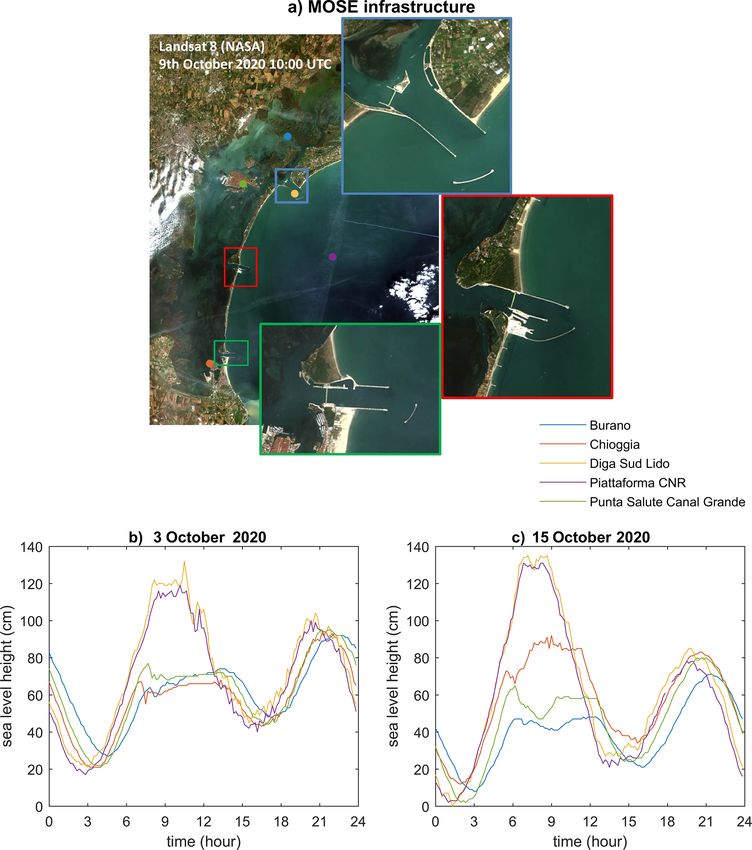
2634 P. Lionello et al.: Venice flooding and sea level – past, present, and future
of the Venetian lagoon system. The Venetian RSL has risen
at an average rate of 2.5 mm per year in the past 150 years
due to mean sea level rise and the sinking of the ground
by natural and anthropogenic subsidence, which accelerated
the RSL rise rate up to 5 mm per year in the period 1950–
1970 (Z2021), leading to an increased frequency of floods
(L2021). The lowest part of the central St Mark’s Square
is approximately 55 cm above the present mean sea level;
nowadays, a positive water height anomaly (see Sect. 3)
that is only a few centimetres above astronomical high tide
(whose amplitude is about 50 cm) can flood it.
The dramatic surge of 4 November 1966 showed, unequiv-
ocally, the need for counteracting an increasing hazard level.
The event reached the highest ever recorded water height
(194 cm) and persisted over 110 cm for 22 h (see L2021; De
Zolt et al., 2006; Cavaleri et al., 2010). Figure 1 shows the
flooding of the central monumental area at a time close to
the peak of the 6 November 1966 event. In 1973, the Ital-
ian government established a legal framework, the Special
Law for Venice, establishing objectives, responsibilities, reg-
ulations, actions, and funding to safeguard Venice and its la-
goon. The solution finally approved by the Italian govern-
ment is a system of large mobile barriers (Modulo Speri-
mentale Elettromeccanico – MoSE) at the three lagoon in-
lets. Barriers will be raised only during severe events, clos-
ing the lagoon inlets and preventing the water height from
exceeding the safeguard level within the lagoon, while, un-
der normal conditions, they lie at the bottom of the lagoon
inlets, allowing water exchange and ship traffic between the
lagoon and the Adriatic Sea. After a long planning phase,
construction started in 2003, and it is foreseen that the bar-
riers will be fully operational at the end of 2021. The recent
event on 12 November 2019 (Cavaleri et al., 2020; Ferrarin
et al., 2021), which has been the second highest water height
(189 cm) ever measured in Venice by a tide gauge, has dra-
matically reconfirmed the need for an adequate defence sys-
tem. November 2019 was the worst month since the begin-
ning of the local tide gauge records for excessive high wa- Figure 1. The present condition of St Mark’s Square during the par-
ters, with 15 events exceeding 110 cm and four events above tial flooding of its lowest areas (estimated water height – 80 cm) and
140 cm. MoSE has already been operated for a few excep- a historical picture close to the time of highest level of the 4 Novem-
ber 1966 flood. The historical photograph is courtesy of Gianfranco
tional events, such as on 3 October 2020, when, for the first
Tagliapietra.
time, the lagoon was cut off, under real hazard conditions,
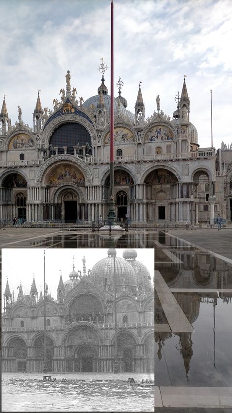
from the Adriatic Sea. While the peak water height during
the event was 130 cm in the Adriatic, it was kept at 70 cm in
the lagoon and at St Mark’s Square and flooding was avoided. derstanding of the Venice flooding phenomenon. It considers
Figure 2 shows an aerial view of the barriers blocking the la- the meteorological and climatic factors producing aqua alta,
goon inlets and the time series of the water height outside its prediction, and its historical and expected future varia-
(Piattaforma CNR) and inside the lagoon (Punta della Salute tions under a globally changing climate. The synthesis is ori-
– Canal Grande represents the tide gauge commonly used as ented toward clarifying consolidated knowledge, highlight-
reference for the sea level in the city centre). ing gaps in knowledge, and identifying major opportunities
A large volume of scientific literature considers the factors for progress.
leading to the flooding of Venice, predicting the timing and This special issue comprises three review articles address-
intensity of the events, and describing changes in their fre- ing three different and complementary aspects of the hazards
quency and intensity under future global warming scenarios. causing the flooding of Venice. Z2021 consider the Venetian
This special issue aims to critically review the current un- RSL evolution on multiple timescales and the factors deter-
Nat. Hazards Earth Syst. Sci., 21, 2633–2641, 2021 https://doi.org/10.5194/nhess-21-2633-2021
P. Lionello et al.: Venice flooding and sea level – past, present, and future                                                   2635

mining it. Umgiesser et al. (2021; hereafter U2021) describe         diurnal K1 providing the largest contributions (23, 14, and
the tools that have been developed and are currently being           16 cm, respectively) both outside the lagoon inlets and in the
used for the prediction of the floods and give recommenda-           city centre (Polli, 1952; Ferrarin et al., 2015)
tions for further improvements. L2021 describe the factors              Hydrodynamics linked to tidal exchange are critical for
leading to extreme water height events, their past evolution,        the great ecological variety and biodiversity of the Venetian
and expected future trends under a climate change perspec-           Lagoon, with habitats ranging from tidal flats, marshlands,
tive. The outcomes of these papers provide a thorough critical       channels and canals, inlets, and tidal deltas with strong hy-
review of the scientific literature. It is, hence, a basis for the   drodynamics and tidal renewals.
assessment of present and future risks and helps to define the          Changes in RSL may critically compromise the ecosys-
requirements of the adaptation strategies that are appropriate       tem functionality by inducing morphodynamic changes that
for Venice over the 21st century.                                    alter the ecological vocation of such areas (Zanchettin et
   This editorial provides an introduction to these three re-        al., 2007). Former studies show that the increase in extreme
views. It briefly provides general background information by         floods since the mid-20th century is explained by the RSL
describing the geographical and historical setting (Sect. 2)         rise (Lionello et al., 2012; L2021). Furthermore, future sea
and the phenomenology of surges and high water levels                level rise (Z2021) might dramatically increase both the fre-
(Sect. 3). Section 4 describes the overall key findings pro-         quency of high sea level events and resulting floods, as well
duced by the three reviews. Implications for future flooding         as increasing the duration and extent of flooding (L2021).
and its management are addressed in Sect. 5 as the conclud-          This reinforces the need to understand the historical context
ing remarks.                                                         of sea level change in Venice and consider its prognosis.

2   Geographical and historical setting                              3   Characteristics of surges and high water levels

The Venetian Lagoon covers about 550 km2 along about                 The floods of Venice are associated with the positive anoma-
50 km of low-lying coast within the easternmost boundary             lies of the water height, defined as being the difference be-
of the Po Plain and is connected to the northern Adriatic            tween the instantaneous sea level and the bottom level. The
Sea through three tidal inlets, namely Lido, Malamocco, and          term “water height” is introduced because considering only
Chioggia (Fig. 3). The historical city is located in the centre      sea level does not account for the fundamental role that the
of the lagoon and is built at a low elevation on a base made         local vertical land motion (subsidence) has and will continue
of wooden piles reaching an underground hard layer and sup-          to have in the increased frequency of floods. The contribu-
porting the buildings.                                               tions leading to large water height anomalies are meteoro-
   The Venetian Lagoon is governed by a fragile equilib-             logical surges, seiches, tides, seasonal-to-decadal sea level
rium, which has been artificially preserved over the centuries       variability, and long-term RSL changes. The meteorological
by contrasting the natural evolution of this transitional area       surges result from three different contributions characterised
that is driven by coastal dynamics via geomorphological (e.g.        by different timescales, i.e. surges produced by planetary at-
erosion and sedimentation), chemical (e.g. salinification), bi-      mospheric waves (PAWs; PAW surges), with durations from
ological, and ecological (e.g. loss of wetlands and other eco-       10 to 100 d, storm surges produced by midlatitude cyclones
topes) changes. Since the 15th century, Venetians have en-           with timescales of a few days, meteotsunamis, and surges
gaged in an enduring struggle against sedimentation in the           produced by mesoscale systems (with a short duration of a
lagoon, mainly by diverting away the major Adige, Bac-               few hours). The characteristics of the different contributions
chiglione, Brenta, Sile, and Piave rivers and their sediment         and the criteria for their distinction are explained in Sect. 2.1
supply, hence altering the morphology of the alluvial plain          and 2.2 of L2021. Note that this terminology differs from
and the coastal margins. Bondesan and Furlanetto (2012)              Gregory et al. (2019) in that the term water height is intro-
provide a recent assessment, based on historical cartography         duced, and the surge is distinguished by three components,
analysis, of the artificial fluvial diversions performed during      thus reserving the term “storm surge” for the component pro-
the 16th and 17th centuries. More recent works in the 19th           duced by the passage of a cyclone.
and 20th centuries include deepening of existing channels               Meteorological surges in Venice are caused by a com-
within the lagoon, the excavation of the “Canale dei Petroli”        bination of various physical processes mainly triggered by
(Oil Channel) and the construction of breakwaters at the la-         the water level in the neighbouring Adriatic Sea. The main
goon’s mouths to allow modern ships to reach the ports of            component of extreme events is the storm surge produced
Giudecca and Marittima in the historic city and, more re-            mostly by the southeasterly wind (sirocco), pushing the wa-
cently, Porto Marghera.                                              ter against the northwestern end of the Adriatic Sea (wind
   The tidal regime is a mixed semidiurnal cycle with a tidal        set-up), and the low atmospheric pressure that increases the
range of more than 1 m at spring tide and only three compo-          mean sea level by 1 cm/mbar of pressure decrease (inverse
nents above 10 cm, with the semidiurnal M2 and S2, and the           barometer effect). The surge produced by atmospheric plane-

https://doi.org/10.5194/nhess-21-2633-2021                                  Nat. Hazards Earth Syst. Sci., 21, 2633–2641, 2021
2636                                                P. Lionello et al.: Venice flooding and sea level – past, present, and future

Figure 2. Pre-operational closures of the MoSE in October 2020. (a) Pseudo true colour pan-sharpened Landsat 8 Operational Land Imager
(OLI) imagery, acquired on 9 October 2020, showing the Venetian Lagoon inlets during a test closure of the MoSE. The Landsat 8 image
is available from the U.S. Geological Survey and was processed by CNR–ISMAR. (b) The water height anomalies measured on 3 October
2020 by tide gauges located within the Venetian Lagoon (Burano, Chioggia, and Punta della Salute – Canal Grande) and in the open Adriatic
Sea (Diga Sud Lido and Piattaforma CNR), showing the effect of the MoSE closure on the water height level inside the lagoon. Panel (c) is
the same as (b) but for the MoSE closure on 15 October 2020.

tary waves and mesoscale atmospheric systems can also pro-             al., 2019). These processes and their superposition leading to
vide a significant contribution. Together with these meteoro-          compound events are described in L2021.
logical processes, the contribution of the regular tides has to           The positive water level anomaly in the Adriatic Sea en-
be considered, which can add about 50 cm during a spring               ters the lagoon nearly undisturbed through the deep inlets (8–
tide (Ferrarin et al., 2015). Another flood process is seiches,        13 m) and then reaches and floods the city centre of Venice
i.e. free oscillations in the Adriatic Sea triggered by the wind       (Umgiesser et al., 2004; U2021). While there might be some
set-up. The main seiches, which have a period of around 23 h,          local water height differences due to the wave set-up outside
very close to that of the diurnal tides, overlie the meteorolog-       the inlets and wind stress inside the lagoon, the water height
ical and tidal processes and may cause flooding – even if the          in the city of Venice closely follows the level outside the la-
main meteorological conditions have calmed down (Bajo et               goon. Wave run-up and infra-gravity waves are not relevant
                                                                       for the water height in the city centre, although they may have

Nat. Hazards Earth Syst. Sci., 21, 2633–2641, 2021                                     https://doi.org/10.5194/nhess-21-2633-2021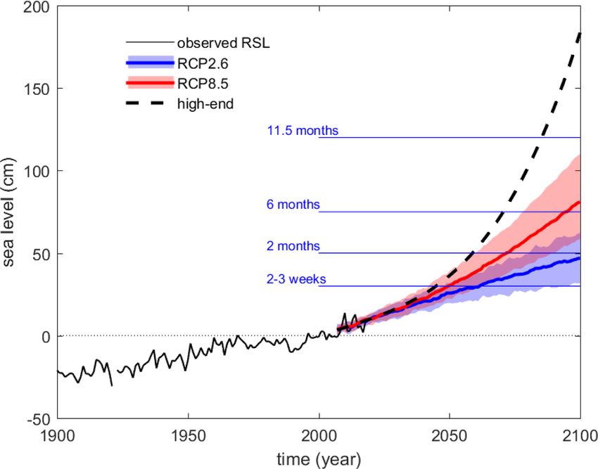
P. Lionello et al.: Venice flooding and sea level – past, present, and future                                                          2637

Figure 3. The lagoon of Venice in the global context. (a) The Mediterranean Sea is connected with the North Atlantic Ocean through the
Strait of Gibraltar. (b) The Venetian Lagoon is located along the northern coast of the Adriatic Sea, a subbasin of the eastern Mediterranean
Sea. (c) The historic centre of Venice (indicated) is located in the middle of the Venetian Lagoon.

an effect at the sea side of the barrier islands separating the          tuations, whose dynamics are not sufficiently understood
lagoon from the sea (see L2021).                                         (L2021), preventing reliable seasonal predictions.
                                                                            The water height forecast (U2021) has paramount impor-
                                                                         tance because it is needed by civil protection for flood warn-
4   Key insights from the papers                                         ings and by the consortium that operates the mobile barriers
                                                                         (MoSE), which are currently in a pre-operational phase at
The important potential role of compound events (resulting               the inlets. Considering the operativity of MoSE, a reliable
from the superposition of the different contributions intro-             forecast should be able to satisfy the requirements of the dif-
duced in Sect. 3) for causing extreme sea levels emerges                 ferent stakeholders, especially in terms of the forecast range
clearly from L2021. Many past studies concentrated on the                and error statistics (Umgiesser, 2000). The present plan is to
storm surge contribution, which was the determinant contri-              operate the barriers and to close the lagoon on the basis of
bution for the 4 November 1966 and the 19 October 2018                   the forecast water level, wind and rain only a few hours be-
events, and on the need for a precise prediction of its tim-             fore the event. The port authority is particularly sensitive to
ing in relation to the phase of the astronomical tide and pre-           unnecessary closures, which produce unmotivated economic
existing seiches. However, the presence of other factors can             losses by limiting the port operations, and want to anticipate
determine extreme sea level events when they act construc-               (in the range from 1 to 2 d) the decision to close in order to
tively, namely planetary atmospheric wave surges and me-                 the facilitate proper management of the ingoing and outgo-
teotsunamis, even if their individual magnitude is not ex-               ing ship traffic. Residents, shopkeepers, and most commer-
ceptionally large (L2021), as was apparent during the re-                cial activities in Venice would support a more conservative
cent 12 November 2019 event (Ferrarin et al., 2021). This                approach that minimises the risk of flood damages to goods
poses a great challenge to the prediction of extreme sea lev-            and property. Therefore, the port authority is interested in
els (U2021) and the management of MoSE. Furthermore,                     avoiding false alarms, while other stakeholders are worried
historic floods show large interdecadal and interannual fluc-

https://doi.org/10.5194/nhess-21-2633-2021                                      Nat. Hazards Earth Syst. Sci., 21, 2633–2641, 2021
2638 P. Lionello et al.: Venice flooding and sea level – past, present, and future
about missing closures. Tourist activities would, in general,
be concerned by cancellations of reservations and visits that
may be caused by an excessive water level forecast.
An operational forecasting system has been in place for the
last 40 years, but further developments are needed to match
the requests of stakeholders and the requirements for oper-
ating MoSE. A lack of accuracy in the forecast of the com-
pound event that led to the exceptional water height maxi-
mum on 12 November 2019 produced a severe underestimate
(up to 45 cm) of the maximum event height by all available
forecast systems (Ferrarin et al., 2021). The need to improve
the operational forecasting system has been further demon-
strated by the flooding of the city on 8 December 2020, when
the MoSE was not operated despite being available because
the forecast underestimated the height of the water level.
Therefore, further developments are needed, particularly the
use of ensemble methods, assimilation of real-time data, and Figure 4. Comparison between the historical evolution of average
sea level and flooding events in Venice and the link with larger-scale
the exploitation of multimodel approaches (U2021). Imple-
changes in sea level. The Venetian sea level is reported as the annual
menting these features in the forecasting systems can (and
average relative sea level and is obtained from measurements by the
should) be done to guarantee an improved and adequate wa- Punta della Salute tide gauge (black line) and as the annual average
ter level forecast in the near future. mean sea level obtained by removing the local subsidence estimate
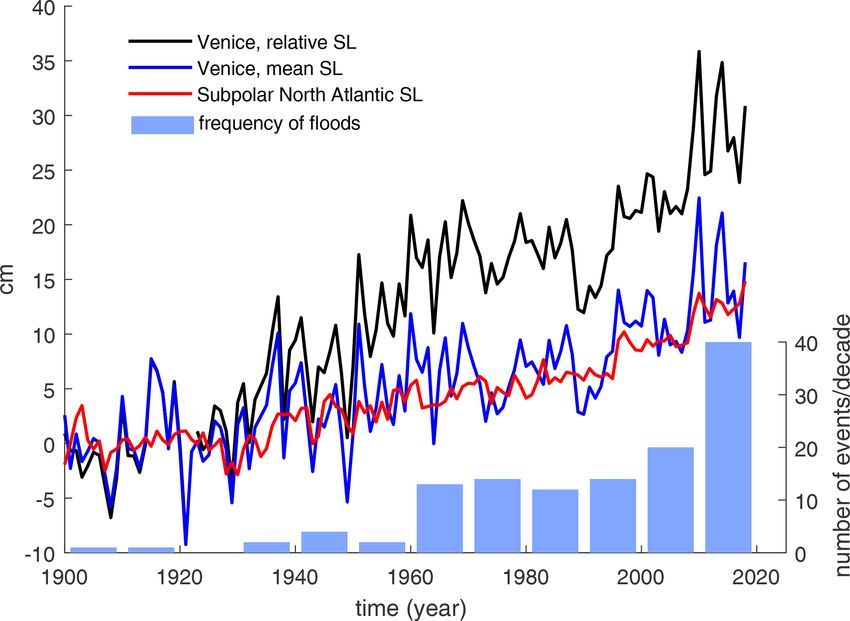
RSL rise is the factor that has produced the past increase in from the tide gauge data (blue line; Z2021). The red line illustrates
the Venice flood frequency. Z2021 show that the 2.5 mm per the evolution of the basin-averaged sea level for the subpolar North
year RSL trend in Venice has been caused in approximately Atlantic, as estimated by Frederikse et al. (2020). Blue bars show
equal parts by land subsidence and mean sea level (MSL) the number of floods exceeding the threshold of 120 cm within each
rise. L2021 show that the increased frequency of floods is at- decade.
tributed to such a RSL rise, with no robust evidence of the
intensification of the meteorological conditions associated
scenario is realised. These values are obtained by consider-
with extreme water heights. Figure 4 summarises these re-
ing the regional analysis of future RSL (Thiéblemont et al.,
sults by showing the RSL rise in Venice and the correspond-
2019), integrated by accounting for centennial natural ver-
ing increase in the frequency of water height maxima above
tical land movement occurring at the past rate, and adding
120 cm, which has increased from less than two events per
a further 10 cm of uncertainty caused by subregional devia-
decade (average frequency during the first half of the 20th
tions from the subpolar North Atlantic sea level (Z2021).
century) to 40 events in the last decade (2010–2019). Con-
Future RSL rise will be the key factor determining the fu-
sidering a lower (110 cm) water height threshold, the num-
ture duration of extreme water heights above the safeguard
ber of events has increased from 4.2 events per decade to 95
thresholds, which correspond to the duration of the closures
events per decade (L2021).
of the inlets by the MoSE mobile barriers. Figure 5 reports
Uncertainty in future greenhouse gas emissions (largely
the RSL thresholds for the closures, based on the consensus
depending on governmental and societal decisions) and
between Lionello (2012) and Umgiesser (2020), and it shows
structural modelling uncertainties (particularly in relation to
that the period of closure will grow at a rate controlled by
the melting of the large Greenland and Antarctic ice sheets)
the RSL rise. Closing the inlets for 3 weeks per year is un-
lead to a wide range of possible future sea level rise sce-
likely before the 2040s but virtually certain before the end of
narios (Z2021). Figure 4 shows that the past MSL in Venice
this century, even under a low-emission scenario (RCP2.6).
closely follows the MSL evolution of the subpolar North At-
Closures of 2 months per year are unlikely before the late
lantic. The differences between these two time series consist
2050s, even under a high-end emission scenario (RCP8.5).
of the interannual and interdecadal sea level fluctuations in
However, they become virtually certain by the late 2080s un-
the North Adriatic, with no sustained different trends. This
der a high-emission scenario and about as likely as not before
study and other studies indicate that future subregional de-
the end of this century for a low-emission scenario. Note that
viations play a minor role in long-term planning and add an
a 6-month closure per year (which can be used as the cri-
uncertainty estimated to be of the order of ±10 cm to the RSL
terion for considering the present defence strategy to be in-
at the end of the 20th century (Z2021). Figure 5 shows a RSL
adequate and requiring new, additional actions) is likely to
rise range from about 30 to 110 cm at the end of the 21st cen-
occur before the end of this century under a high-emission
tury (with a wider 10 to 120 cm range, accounting for the un-
scenario.
certainty associated with subregional deviations). This could
grow to above 180 cm if an unlikely, but plausible, high-end
Nat. Hazards Earth Syst. Sci., 21, 2633–2641, 2021 https://doi.org/10.5194/nhess-21-2633-2021P. Lionello et al.: Venice flooding and sea level – past, present, and future 2639
many centuries and longer is inevitable in Venice (Z2021).
Importantly, however, most subsidence in the last 100 years
was due to human actions (largely groundwater withdrawal).
Since the 1970s, regulation and the provision of alterna-
tive sources of water for industrial, agricultural, and civil
use have avoided such subsidence. It is important that these
successful regulations to control human-induced subsidence
continue to be enforced in the future. Efforts could even be
strengthened further, as some localised subsidence can still
be measured linked to construction works and related activi-
ties (Tosi et al., 2018). Costs, benefits, and the practicality of
the required measures might be considered in the context of
building regulations and permits. Therefore, future human-
induced contributions to local subsidence can be controlled
based on historic experience and awareness.
In contrast, most ongoing and projected future climate-
induced sea level rise is a result of global actions concern-
Figure 5. Projected relative sea level change in Venice in the con- ing greenhouse gas emissions and the resulting temperature
text of historical observations. Observations are the annual mean rise. It is, therefore, of paramount importance to identify and
tide gauge relative sea level height anomalies with respect to the support collective global actions to reduce such emissions,
2000–2007 average. Projections are based on two reference scenar-
especially with respect to the Paris Agreement. It is also im-
ios of anthropogenic greenhouse gas emissions, namely Represen-
tative Concentration Pathway 2.6 (RCP2.6; low emission scenario)
portant for Venice, as in other coastal jurisdictions around
and RCIP8.5 (strong emission scenario), and a high-end scenario the world, to stay aware of future expectations about sea
illustrating a plausible evolution obtained by combining the high- level rise and to plan accordingly. The regular assessments
est estimates of all individual contributions to relative sea level rise of the Intergovernmental Panel on Climate Change (IPCC)
(shading – 5–95 percentile range; line – median). The horizontal are especially important in this regard, with the Sixth As-
blue lines show the relative mean sea level thresholds for annual sessment to be published in 2021. Currently, it is not clear
persistence of the relative sea level above the present safeguard level whether the world is heading towards emissions more com-
(persistence durations of 2–3 weeks; 2, 6, and 11.5 months have parable to RCP4.5 or RCP6.0 (Hausfather and Peters, 2020)
been considered). These time intervals approximately correspond rather than to RCP8.5 (Schwalm et al., 2020). With further
to the annual duration of the expected closures of MoSE. reductions, having emissions close to RCP2.6 (following the
Paris Agreement) is a plausible, albeit challenging, target to
achieve. However, the recent IPCC Special Report on the
RSL rise will also be the key factor responsible for the fu-
Ocean and Cryosphere in a Changing Climate (Oppenheimer
ture increase in extreme sea level frequency and height, while
et al., 2019) has emphasised the fundamental point that sta-
the reduction in the intensity of meteorological events and the
bilising temperature does not stabilise sea level but, rather,
changes in tidal regimes will play a secondary role (L2021).
the rate of sea level rise.
In the case of a high-emission scenario the magnitude of one
Hence, some RSL rise is inevitable for Venice, and ex-
sea level event in 100 years at the northern Adriatic coast is
treme water heights and flood potential will grow; uncer-
projected to increase by up to 65 % in 2050 and 160 % in
tainty concerns only the rate of this increase. Significant as-
2100 with respect to the present value, thereafter continuing
pects of this uncertainty relate to future emissions, the re-
to increase through the 22nd century and beyond (L2021).
sponse of the Greenland and Antarctic ice sheets to global
temperature rise, and future subsidence of the Venetian La-
5 Implications for future flooding and its management goon. It is important to remember that Venice has adapted to
RSL rise through its more than 1000-year history. Hence, the
The insights from the three review articles have important adaptation actions since the 1966 floods, comprising both lo-
implications for our understanding of the future occurrence cal adaptation (by raising parts of the historical centre) and
of floods in Venice and their management. They demon- large-scale adaptation for the whole lagoon (the construction
strate that RSL rise has been and will continue to be the of the MoSE barriers) continue this tradition. With the MoSE
main driver of increasing extreme water heights and increas- barriers being fully commissioned in 2021, the risks of flood-
ing flood potential. Projected future RSL rise is the prod- ing in Venice will be greatly reduced. However, as the RSL
uct of local changes due to subsidence and regional and is still rising and is projected to rise beyond the 21st century,
global trends linked to human-induced climate change. Nat- even with the Paris Agreement being fully implemented, ulti-
ural background subsidence (up to around 1 mm per year) mately even this new, world-class adaptation system will be
due to enduring long-term geological trends apparent over challenged. The critical question is when a new adaptation
https://doi.org/10.5194/nhess-21-2633-2021 Nat. Hazards Earth Syst. Sci., 21, 2633–2641, 20212640 P. Lionello et al.: Venice flooding and sea level – past, present, and future
strategy will be required, while being aware that, consider- Acknowledgements. The authors thank Federica Braga of ISMAR–
ing the uncertainty of future RSL scenarios, it might happen, CNR for providing the image used in Fig. 2a. The scientific activity
in the worst case, within a few decades or maybe much later, by Georg Umgiesser and Davide Zanchettin, performed in the Re-
during the 22nd century. This suggests that experience from search Programme Venezia 2021, with the contribution of the Su-
the long-term planning for sea level rise under uncertainty perintendency for the Public Works of Veneto, Trentino Alto Adige,
and Friuli Venezia Giulia, provided through the concessionary of
that is being carried out in locations such as London (Ranger
the state of Consorzio Venezia Nuova and coordinated by Consorzio
et al., 2013) and is drawing on adaptation pathways more per il Coordinamento delle Richerche inerrenti al Sistema Lagunare
widely (Haasnoot et al., 2019) should also be considered in di Venezia (CORILA), is acknowledged.
the Venetian context. The authors thank Gianfranco Tagliapietra for the historical
Finally, the recognition of the possible role of compound photo of the flooding of St Mark’s Square on 4 November 1966.
flood events due to superimposed extreme water heights
drivers shows the potential for improved flood forecasts in
Venice, which, in turn, will allow for better control of the Review statement. This paper was edited by Uwe Ulbrich and re-
MoSE barriers. Thus, the improved understanding and fore- viewed by two anonymous referees.
casting of short-term events will contribute to better long-
term adaptation in Venice. With such improved forecasts and
greater confidence in those forecasts, this has the potential to
References
extend the operational range of the MoSE barriers and its life
as an adaptation tool for Venice. This needs to be more fully Bajo, M., Med̄ugorac, I., Umgiesser, G., and Orlić, M.: Storm surge
explored. and seiche modelling in the Adriatic Sea and the impact of data
assimilation, Q. J. Roy. Meteor. Soc., 145, 2070–2084, 2019.
Bondesan, A. and Furlanetto, P.: Artificial fluvial diversions in the
Data availability. The subpolar North Atlantic sea level data, mainland of the Lagoon of Venice during the 16th and 17th
as estimated by Frederikse et al. (2020a) and used in Fig. 4, are centuries inferred by historical cartography analysis, Géomorph.
available at https://doi.org/10.5281/zenodo.3862995 (Frederikse Rel. Proc. Environ., 18, 175–200, 2012.
et al., 2020b). The data on the frequency of floods (shown in Cavaleri, L., Bertotti, L., Buizza, R., Buzzi, A., Masato, V.,
Fig. 4) are available at https://www.comune.venezia.it/it/content/ Umgiesser, G., and Zampieri, M.: Predictability of extreme
distribuzione-decennale-delle-alte-maree-110-cm (CPSM, 2021). meteo-oceanographic events in the Adriatic Sea, Q. J. Roy. Me-
Observed tide gauge data (Punta della Salute) are available from teor. Soc., 136, 400–413, 2010.
the ISPRA website at https://www.venezia.isprambiente.it/index. Cavaleri, L., Bajo, M., Barbariol, F., Bastianini, M., Benetazzo,
php?folder_id=20&stazione_id=129&tipo_dati_id=1&view=year A., Bertotti, L., Chiggiato, J., Ferrarin, C., Trincardi, F., and
(ISPRA, 2021). Historical tide gauge data for Venice (used Umgiesser, G.: The 2019 Flooding of Venice and its implications
in Fig. 4) and sea-level projections for Venice for RCP2.6, for future predictions, Oceanography, 33, 42–49, 2020.
RCP8.5, and a high-end scenario (used in Fig. 5) are available at CPSM: Distribuzione decennale delle alte maree, avail-
https://doi.org/10.5281/zenodo.5139890 (Zanchettin, 2021b). able at: https://www.comune.venezia.it/it/content/
distribuzione-decennale-delle-alte-maree-110-cm, last ac-
cess: 1 August 2021.
Author contributions. PL coordinated the writing of the article. De Zolt, S., Lionello, P., Nuhu, A., and Tomasin, A.: The dis-
PL, GU and DZ contributed the material from the articles L2021, astrous storm of 4 November 1966 on Italy, Nat. Hazards
U2021, and Z2021, respectively. RJN led the discussion in Sect. 5. Earth Syst. Sci., 6, 861–879, https://doi.org/10.5194/nhess-6-
DZ produced Figs. 3, 4, and 5. 861-2006, 2006.
Enzi, S. and Camuffo, D.: Documentary sources of the sea surges in
Venice from ad 787 to 1867, Nat. Hazards, 12, 225–287, 1995.
Competing interests. The authors declare that they have no conflict Ferrarin, C., Tomasin, A., Bajo, M., Petrizzo, A., and Umgiesser,
of interest. G.: Tidal changes in a heavily modified coastal wetland, Cont.
Shelf Res., 101, 22–33, 2015.
Ferrarin, C., Bajo, M., Benetazzo, A., Cavaleri, L., Chiggiato, J.,
Davison, S., Davolio, S., Lionello, P. Orlić, M., and Umgiesser,
Disclaimer. Publisher’s note: Copernicus Publications remains
G.: Local and large-scale controls of the exceptional Venice
neutral with regard to jurisdictional claims in published maps and
floods of November 2019, Prog. Oceanogr., 197, 102628,
institutional affiliations.
https://doi.org/10.1016/j.pocean.2021.102628, 2021.
Frederikse, T., Landerer, F., Caron, L., Adhikari, S., Parkes, D.,
Humphrey, V. W., Dangendorf, S., Hogarth, P., Zanna, L., Cheng,
Special issue statement. This article is part of the special issue L., and Wu, Y.-H.: The causes of sea-level rise since 1900, Na-
“Venice flooding: understanding, prediction capabilities, and future ture, 584, 393–397, 2020a.
projections”. It is not associated with a conference. Frederikse, T., Landerer, F., Caron, L., Adhikari, S., Parkes,
D., Humphrey, V. W., Dangendorf, S., Hogarth, P., Zanna,
L., Cheng, L., and Wu, Y.-H.: Data supplement for “The
Nat. Hazards Earth Syst. Sci., 21, 2633–2641, 2021 https://doi.org/10.5194/nhess-21-2633-2021P. Lionello et al.: Venice flooding and sea level – past, present, and future 2641 causes of sea-level rise since 1900”, Zenodo [data set], Schwalm, C. R., Glendon, S., and Duffy, P. B.: Reply to Hausfather https://doi.org/10.5281/zenodo.3862995, 2020b. and Peters: RCP8. 5 is neither problematic nor misleading, P. Gregory, J. M., Griffies, S. M., Hughes, C. W., Lowe, J. A., Church, Natl. Acad. Sci. USA, 117, 27793–27794, 2020. J. A., Fukimori, I., Gomez, N., Kopp, R.E., Landerer, F., Le Thiéblemont, R., Le Cozannet, G., Toimil, A., Meyssignac, B., and Cozannet, G., Ponte, R.M., Stammer, D., Tamisiea, M. E., and Losada, I. J.: Likely and High-End Impacts of Regional Sea- van de Wal, R. S.: Concepts and terminology for sea level: Mean, Level Rise on the Shoreline Change of European Sandy Coasts variability and change, both local and global. Surv. Geophys., 40, Under a High Greenhouse Gas Emissions Scenario, Water, 11, 1251–1289, 2019. 2607, https://doi.org/10.3390/w11122607, 2019. Haasnoot, M. Brown, S., Scussolini, P., Jimenez, J. A., Vafeidis, Tosi, L., Lio, C. D., Teatini, P., and Strozzi, T.: Land sub- A. T., and Nicholls, R. J.: Generic adaptation pathways for sidence in coastal environments: knowledge advance in the coastal archetypes under uncertain sea-level rise, Environm. Res. Venice Coastland by TerraSAR-X PSI, Remote Sens., 10, 1191, Comm., 1, 071006, https://doi.org/10.1088/2515-7620/ab1871, https://doi.org/10.3390/rs10081191, 2018. 2019. Umgiesser, G., Melaku Canu, D., Cucco, A., and Solidoro, C.: A Hausfather, Z. and Peters, G. P.: Emissions – the “business as usual” finite element model for the Venice Lagoon. Development, set story is misleading, Nature 577, 618–620, 2020. up, calibration and validation, J. Marine Sys., 51, 123–145, 2004. Istituto Superiore per la Protezione e la Ricerca Ambien- Umgiesser, G.: The impact of operating the mobile barriers in tale (ISPRA): Punta della Salute tide gauge data, avail- Venice (MOSE) under climate change, J. Nat. Conserv., 54, able at: https://www.venezia.isprambiente.it/index.php?folder_ 125783, https://doi.org/10.1016/j.jnc.2019.125783, 2020. id=20&stazione_id=129&tipo_dati_id=1&view=year, last ac- Umgiesser, G., Bajo, M., Ferrarin, C., Cucco, A., Lionello, P., cess: 1 August 2021. Zanchettin, D., Papa, A., Tosoni, A., Ferla, M., Coraci, E., Lionello, P.: The climate of the Venetian and North Adriatic region: Morucci, S., Crosato, F., Bonometto, A., Valentini, A., Orlić, Variability, trends and future change, Phys. Chem. Earth., 40–41, M., Haigh, I. D., Nielsen, J. W., Bertin, X., Fortunato, A. B., 1–8, 2012 Pérez Gómez, B., Alvarez Fanjul, E., Paradis, D., Jourdan, D., Lionello, P., Cavaleri, L., Nissen, K. M., Pino, C., Raicich, F., Pasquet, A., Mourre, B., Tintoré, J., and Nicholls, R. J.: The and Ulbrich, U.: Severe marine storms in the Northern Adriatic: prediction of floods in Venice: methods, models and uncertainty Characteristics and trends, Phys. Chem. Earth., 40–41, 93–105, (review article), Nat. Hazards Earth Syst. Sci., 21, 2679–2704, 2012. https://doi.org/10.5194/nhess-21-2679-2021, 2021. Lionello, P., Barriopedro, D., Ferrarin, C., Nicholls, R. J., Orlić, Zanchettin, D., Traverso, P., and Tomasino, M.: Observations on M., Raicich, F., Reale, M., Umgiesser, G., Vousdoukas, M., and future sea level changes in the Venice lagoon, in: Lagoons and Zanchettin, D.: Extreme floods of Venice: characteristics, dy- Coastal Wetlands in the Global Change Context: Impacts and namics, past and future evolution (review article), Nat. Hazards Management Issues, edited by: Viaroli, P., Lasserre, P., and Cam- Earth Syst. Sci., 21, 2705–2731, https://doi.org/10.5194/nhess- postrini, P., Hydrob., 577, 41–53, 2007. 21-2705-2021, 2021. Zanchettin, D., Bruni, S., Raicich, F., Lionello, P., Adloff, F., An- Oppenheimer, M., Glavovic, B., Hinkel, J., Van de Wal, R., Mag- drosov, A., Antonioli, F., Artale, V., Carminati, E., Ferrarin, C., nan, A. K., Abd-Elgawad, A., Cai, R., Cifuentes-Jara, M., De- Fofonova, V., Nicholls, R. J., Rubinetti, S., Rubino, A., Sannino, conto, R. M., and Ghosh, T.: Sea level rise and implications G., Spada, G., Thiéblemont, R., Tsimplis, M., Umgiesser, G., Vi- for low-lying islands, coasts and communities, IPCC Special gnudelli, S., Wöppelmann, G., and Zerbini, S.: Sea-level rise in Report on the Ocean and Cryosphere in a Changing Climate, Venice: historic and future trends (review article), Nat. Hazards edited by: Pörtner, H.-O., Roberts, D. C., Masson-Delmotte, V., Earth Syst. Sci., 21, 2643–2678, https://doi.org/10.5194/nhess- Zhai, P., Tignor, M., Poloczanska, E., Mintenbeck, K., Alegría, 21-2643-2021, 2021a. A., Nicolai, M., Okem, A., Petzold, J., Rama, B., and Weyer, Zanchettin, D., Bruni, S., Thieblemont, R., and Rubinetti, S.: Data N. M., available at: https://www.ipcc.ch/site/assets/uploads/sites/ from the article Zanchettin, D. et al.: Sea-level rise in Venice: 3/2019/11/08_SROCC_Ch04_FINAL.pdf (last access: 1 August historic and future trends (review article), Zenodo [data set], 2021), 2019. https://doi.org/10.5281/zenodo.5139890, 2021b. Polli, S.: Propagazione della marea nella laguna di Venezia, Ann. Geophys., 5, 273–292, 1952. Ranger, N., Reeder, T., and Lowe, J.: Addressing “deep” uncertainty over long-term climate in major infrastructure projects: four in- novations of the Thames Estuary 2100 Project, EURO J. Decis. Process., 1, 233–262, 2013. https://doi.org/10.5194/nhess-21-2633-2021 Nat. Hazards Earth Syst. Sci., 21, 2633–2641, 2021
You can also read