Version 5 March 2018 - Auckland Design Manual
←
→
Page content transcription
If your browser does not render page correctly, please read the page content below
UNITARY PLAN

             Your Easy Guide to understanding
             the Residential Standards

                  waste       outlook         landscapes

                 height        context         fencing

                 parking   street interface   daylight

        3
Version 5
June 2017
March 2018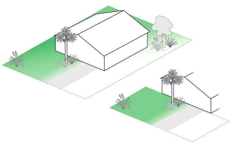
The Easy Guide to the Unitary Plan
    This booklet is part one of a series of tools that have been created by the Auckland Design Manual
    team, to help you navigate the Unitary Plan and work out what you can build on your site.

        UNDERSTAND THE RULES                   APPLY THE RULES                  WORKED EXAMPLES

    The purpose of the Easy Guide to the Unitary Plan is to help you to understand what the
    residential standards and terms mean for your own residential project.

    This guide covers the core standards you must meet to build a permitted development
    (i.e. does not require a resource consent).

    The Easy Guide to the Unitary Plan is a supplementary resource. Whilst every effort has been
    made to ensure the accuracy of this guide, the Unitary Plan must be referred to in the case of any
    uncertainty. The purpose of this guide is to support your understanding of the new residential
    standards that are set out within the plan.

    Drop into an Auckland Council service centre and talk to a duty planner if you need further help
    with interpreting the standards.

    Please note some of the Unitary Plan standards are under appeal, and may be subject to change.

    ABOUT THE AUCKLAND DESIGN MANUAL:
    The Auckland Design Manual is a fantastic free resource that’s been created to help you through
    your design concept and development phase. It’s a practical guide that sits alongside the Unitary
    Plan. If the Unitary Plan is your rule book, think of the Design Manual as your ‘how to guide.’ You
    can use it for inspiration and guidance, it will help you to visualise what you can build in Auckland.

    The Design Manual can support you through the following stages of your development process:

    •   Inspiration for what you could build on your site
    •   Understanding the rules
    •   Developing a design

1
WHAT IS A STANDARD?
A standard is essentially a ‘rule’ that sets out what you can and can’t do on your site.
Your development must meet all the standards in order to be a legal build.

This guide covers the core residential standards you must meet to build a permitted development
(i.e. does not require a resource consent).

Please note that there are additional standards that are specific to each zone and these should also
be referred to in the Unitary Plan.

WHAT IS A SITE?
Your site is defined by official government survey marks.

A site can refer to one or more lots. A map of property boundaries is kept in public records.

Before you undertake any development on your site, the first thing you will need is a clear and
accurate map marking your property boundary.

WHAT IS THE NET SITE AREA?
Net site area is an important variable for calculating spatial requirements on your site such as your
building coverage, and the amount of landscaping you need.

The net site area is the total area of a site excluding:

•   any area subject to a road widening designation;
•   any part of an entrance strip;
•   any legal right of way; and
•   any access site.

If you are unsure of any of these, it is recommended that you speak to your local planner.

WHAT IS THE SITE FRONTAGE?
The site frontage is defined as the entire length of the site boundary that faces the road. Knowing
this length is important for when you are considering fencing options and site access.

WHAT IS RESIDENTIAL CHARACTER?
Residential character refers to the look and feel of a neighbourhood - it’s what makes a suburban
neighbourhood different from an industrial area, or town centre.

Each area will have a particular character, created by similarities that prevail there. It may be that
most buildings have a similar height, or the same set back from the street, or a predominance of
red brick.

                                                                                                         2
BUILDING HEIGHT
Building height has a significant impact on the appearance and character of an area.
The building height standard is in place to limit the height of buildings.
Each zone has different height restrictions.
‘Height’ is measured as the vertical distance between the highest part of the building
(or structure) and ground level.
‘Ground Level’ refers to the existing ground height before any earthworks occur.
Height standards for each zone refer to the maximum height allowed. There are small allowances
for roof gables and structures like lift towers or chimneys – the standards for each zone will
explain this.
8m + additional 1m
allowance for roof form
1m
8m
* This diagram shows how the standard is applied in the Mixed Housing Suburban (MHS) zone.
See table on p.15 which outlines the criteria for applying the standard in other zones.
3HEIGHT IN RELATION TO BOUNDARY
This standard is to manage the potential impact that a new building or addition might have on the
neighbours.
It is important that your new development doesn’t block out your neighbour’s daylight.
Height in relation to boundary is measured vertically from ground level at the boundary (height
varies between zones). From that point measure inwards at an incline of 45 degrees (this is termed
the recession plane).
This creates an invisible envelope that the building must be contained in.
This standard applies to the side and rear boundaries of the site, but not at the street front.
Height at boundary differs between zones. In the Mixed Housing Suburban (MHS) and Single
House zones the height at boundary is 2.5m. In Mixed Housing Urban (MHU) and Terraced
Housing and Apartment Buildings (THAB) zones, the height at boundary is increased to 3m, with a
45° angle recession plane.
Recession plane
45° angle 45° angle
2.5m
Height at boundary
2.5m
* This diagram shows how the standard is applied in the Mixed Housing Suburban (MHS) zone.
See table on p.15 which outlines the criteria for applying the standard in other zones.
4BUILDING COVERAGE
Building coverage is essentially the building footprint and is measured as a percentage of the site.
This standard ensures the site has a generally spacious feeling. Building coverage is different for
each zone.
Along with height limits, it manages the bulk or size of buildings and therefore influences the
character and appearance of an area.
The building coverage standard applies only to the ‘net site area’ (see page 3 for definition).
Building coverage includes:
• overhanging or cantilevered parts of buildings
• any part of the eaves or spouting that extends more than 750mm horizontally from the
exterior wall of the building
• accessory buildings, such as sheds and sleep-outs.
It does not include:
• uncovered swimming pools
• pergolas
• uncovered decks
• open structures that are not buildings, such as a garden archway.
erage
% a cov
4e0t site are bui
lding
n
of %
40
of
m
xi mu
Ma
* This diagram shows how the standard is applied in the Mixed Housing Suburban (MHS) zone.
See table on p.16 which outlines the criteria for applying the standard in other zones.
5YARD CONTROLS
Yards are important because they provide space for buildings and services to be maintained, and
improve the residential character and the general appeal of a street.
The yard area must be kept clear of buildings and structures from the ground upward. Rear & side
yards can include planting, as long as there is still access.
Yards are always measured at right angles (90°) to the site boundary.
These yard controls are the minimum amount of space required between the relevant site
boundary and the building.
REA
RY
ARD
1m
1m
FRO A RD
NT EY
YAR SID
D
3m 1m
* This diagram shows how the standard is applied in the Mixed Housing Suburban (MHS) zone.
See table on p.16 which outlines the criteria for applying the standard in other zones.
6OUTLOOK SPACE
This standard is to make sure living spaces and bedrooms have windows that provide access to
daylight, adequate privacy and enough of an outlook to create a sense of space.
Outlook spaces can be within a site or can overlook a public street or public open space. The
outlook space must be clear of other buildings and must not overlap the outlook space from
another dwelling.
The outlook space is measured from the centre of a window of a living space or bedroom.
If there is more than one window in a room, it is measured from the largest one. The amount of
outlook space from a room differs according to its use.
Minimum dimensions for outlook space from windows are:
• A main living room must have an outlook space with a minimum dimension of 6m in depth
and 4m in width
• A principal bedroom must have an outlook space with a minimum dimension of 3m in depth
and 3m in width
• All other habitable rooms must have an outlook space with a minimum dimension of 1m in
depth and 1m in width.
1m 1m
6m 4m
3m 3m
Habitable
Principal Room
Principal
Bedroom Living Room
* Please note that Outlook controls only apply in Mixed Housing Suburban, Mixed Housing Urban, and
Terraced Housing and Apartment Buildings zones. See table on p.18.
7DAYLIGHT
This standard is to ensure rooms are healthy and pleasant to live in by providing access to daylight
for buildings on the same site.
Buildings must be spaced far enough apart to let enough daylight into the main windows.
In practice, this standard means that the space between buildings will be calculated at half the
height of the adjacent building’s wall.
building
height
space between buildings = half building height
8IMPERVIOUS SURFACES
Impervious surfaces are anything which stop or significantly slow water soaking into the ground.
The main purpose of this standard is to manage the amount of stormwater runoff from a site,
which in turn reduces the risk of flooding and strain on the stormwater network during heavy
rainfall.
It is also there to improve the overall appearance of individual sites and the surrounding
neighbourhood.
Each zone has different site allowances for impermeable surfaces and is measured as a proportion
of the overall site size.
Impervious surfaces include:
• roofs;
• paved areas including patios, driveways and sealed or compacted metal parking areas, sealed
and compacted metal roads;
• layers engineered to be impervious such as compacted clay .
Consider the following to improve water soakage and prevent excessive rain runoff:
• grass and bush areas;
• gardens and other vegetated areas, including living roofs (with soil and plants on top of the
roof);
• porous or permeable paving;
• permeable artificial surfaces, fields or lawns;
• slatted decks.
s
viou
per
be im
can
site
the
of
%
60
mum
M axi
* This diagram shows how the standard is applied in the Mixed Housing Suburban (MHS) zone.
See table on p.17 which outlines the criteria for applying the standard in other zones.
9OUTDOOR LIVING SPACE
This standard is to make sure that people have access to usable, flat outdoor space.
Outdoor living space must be a minimum of 20m2.
Every edge of the outdoor living space must be at least 4m.
It is important that outdoor living space gets sunlight, therefore it must not be south-facing.
Outdoor living space must be directly accessible from a main living area, dining room, or kitchen.
For safety reasons, outdoor living spaces must be separate from driveways or turning bays.
Outdoor living spaces must be clear of any buildings, except for the following:
• pools
• building eaves
• pergolas, lattice fences or similar open structures
• decks and terraces.
20m 2
min
imu ion
ma ns
rea 4m imed
um
inim
m
* This diagram shows how the standard is applied in the Mixed Housing Suburban (MHS) zone.
See table on p.18 which outlines the criteria for applying the standard in other zones.
10FRONT FENCES
Front fences are an option for providing privacy for houses.
It is important that they don’t block the view to the street. This is to increase safety, especially
child safety around driveways. It also means you can watch out for your neighbours, and the
people walking on your street.
There are three different compliant options for front fences, to suit various needs:
• Maximum height of 1.4m across the whole length of the frontage;
• Maximum height of 1.8m for half of the frontage with 1.4m elsewhere;
• Maximum height of 1.8m if the fence is 50% open (e.g. permeable fencing or landscaping).
Maximum height of fencing is measured from the ground height at the boundary, and always
includes any retaining walls.
Maximum 1.8m
50% permeable
Maximum1.4m
across frontage
11REAR & SIDE FENCES
Rear and side fences provide privacy for houses and separation between neighbours.
The maximum height for rear and side fences is 2m, and can include fences, walls and landscaping.
Maximum height of fencing is measured from the ground height at the boundary, and includes any
retaining walls.
Where a side yard meets the front yard, the height must drop to the height of front yard fence
(see diagram below). At this point consider permeable fencing so that you can see pedestrians
when you are pulling out of your driveway.
Maximum
2m Maximum
2m
Drop to meet
height of front
fence FRO
NT
YAR
D
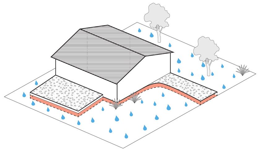
12LANDSCAPED AREA
Landscaped areas are important because they improve the overall quality of individual sites and
the surrounding neighbourhood.
Landscaped areas can include grass, trees and any pathways under 1.5m in width. Up to 25% of
landscaped areas may include additional landscape features, including:
• paved areas, where pavers are a maximum of 650mm
• uncovered decks that are less than 1m in height above the ground.
Landscaped areas do not include any spaces that:
• are considered part of the building coverage area;
• are part of an impervious pathway (such as a concrete path) more than 1.5m in width;
• are used for the parking, manoeuvring or loading of motor vehicles.
Landscaped areas can be over an underground structure (such as underground parking) as long as
there is enough soil depth and drainage.
The use of permeable artificial lawn is permitted – see Unitary Plan definition, or speak to your
planner for further information.
40%
of n
et s
ite a
rea
50%
of f
ron
t ya
rd
* This diagram shows how the standard is applied in the Mixed Housing Suburban (MHS) zone.
See table on p.17 which outlines the criteria for applying the standard in other zones.
13VEHICLE ACCESS AND PARKING
Vehicle access from the road into the site requires a vehicle crossing. One vehicle crossing is
allowed for every 25m of a site’s road frontage.
There must be a 2m separation from vehicle crossings to adjacent sites.
Generally, the width of a vehicle crossing at the site boundary for a single dwelling is 2.75m - 3m
and the minimum width of the driveway within the site is 2.5m.
There are different car parking requirements for dwellings according to zones and various
measurements for the design of parking within the site.
Some zones do not require any on-site car parking and others have a minimum requirement of one
car park per dwelling. Refer to the Unitary Plan’s Transport chapter for more specific information
on vehicle access and parking requirements.
Minimum
2.5m
Maximum 3m at
site boundary
Minimum
2m
14STANDARD TABLES
The following tables are a guide to measurements and criteria for standards in each zone.
Please note some of these standards are under appeal, and may be subject to change.
BUILDING HEIGHT
Zone Height Limit
Large Lot 8 metres, plus additional 1 metre to allow for roof forms
Rural & Coastal Settlement 8 metres, plus additional 1 metre to allow for roof forms
Single House 8 metres, plus additional 1 metre to allow for roof forms
Mixed Housing Suburban 8 metres, plus additional 1 metre to allow for roof forms
11 metres, plus additional 1 metre to allow for roof
Mixed Housing Urban
forms
Terraced Housing &
16 metres (or otherwise shown on variation control)
Apartment Buildings
HEIGHT IN RELATION TO BOUNDARY
Zone Maximum Vertical Height
Large Lot
Rule does not apply to these zones
Rural & Coastal Settlement
45˚ recession plane from a point 2.5m vertically above
Single House
ground level along side and rear boundaries
45˚ recession plane from a point 2.5m vertically above
Mixed Housing Suburban
ground level along side and rear boundaries
45˚ recession plane from a point 3m vertically above
Mixed Housing Urban
ground level along side and rear boundaries
Terraced Housing & 45˚ recession plane from a point 3m vertically above
Apartment Buildings ground level along side and rear boundaries
15BUILDING COVERAGE
Zone Maximum Building Coverage
20% of site or 400 square metres – whichever is the
Large Lot
smaller
20% of site or 200 square metres – whichever is the
Rural & Coastal Settlement
smaller
Single House 35% of net site area
Mixed Housing Suburban 40% of net site area
Mixed Housing Urban 45% of net site area
Terraced Housing &
50% of net site area
Apartment Buildings
YARD CONTROLS
Minimum Minimum Minimum Riparian Coastal
Zone Lakeside
Front Yard Side Yard Rear Yard (Streams) Protection
Large Lot 10m 6m 6m 10m 30m 25m
Rural & Coastal
5m 1m 1m 10m 30m 20m
Settlement
Single House 3m 1m 1m 10m 30m 10m
Mixed Housing
3m 1m 1m 10m 30m 10m
Suburban
Mixed Housing
2.5m 1m 1m 10m 30m 10m
Urban
Terraced Housing
& Apartment 1.5m 1m 1m 10m 30m 10m
Buildings
16IMPERVIOUS SURFACES
Zone Maximum Impervious Area
35% of site or 1400 square metres – whichever is the
Large Lot
smaller
35% of site or 1400 square metres – whichever is the
Rural & Coastal Settlement
smaller
Single House 60% of site
Mixed Housing Suburban 60% of site
Mixed Housing Urban 60% of site
Terraced Housing &
70% of site
Apartment Buildings
LANDSCAPED AREA
Zone Minimum Landscaping
Large Lot
Rule does not apply to these zones
Rural & Coastal Settlement
40% of net site area (this must include half the front
Single House
yard as a landscaped area)
40% of net site area (this must include half the front
Mixed Housing Suburban
yard as a landscaped area)
35% of net site area (this must include half the front
Mixed Housing Urban
yard as a landscaped area)
Terraced Housing &
30% of net site area
Apartment Buildings
17OUTLOOK SPACE
Zone Minimum Outlook Area
Large Lot
Rural & Coastal Settlement Rule does not apply to these zones
Single House
Mixed Housing Suburban • Main living room: minimum of 6m in depth and 4m
in width
Mixed Housing Urban • Principal bedroom: minimum of 3m in depth and 3m
in width
Terraced Housing &
• Other habitable rooms: minimum of 1m in depth
Apartment Buildings
and 1m in width
OUTDOOR LIVING SPACE
Minimum Outdoor Living
Minimum Outdoor
Space for principal living
Zone Living Space located at
rooms located above
ground level
ground level
Large Lot
Rural & Coastal Settlement Rule does not apply to these zones
Single House
Mixed Housing Suburban
• 5m2 for 1 bedroom or
studio
Mixed Housing Urban 20m2
• 8m2 for 2 bedroom or
Terraced Housing & more
Apartment Buildings
18YOU MAY ALSO BE INTERESTED IN....
Use the Residential Standards Checklists to apply the rules to your
APPLY THE RULES own project. The Design Manual provides illustrated checklists for
each zone and covers a range of housing types.
The Worked Examples showcase designs that align with the Unitary
WORKED EXAMPLES Plan, to give you clarity around what a great design could look like
under the new rules.
Delve into the residential design guides to expand your knowledge
of how to deliver great value for your project.
DESIGN GUIDES
These non-statutory guides are based on international best
practice standards. Currently the Design Manual has guides for:
• Detached Housing
• Terraces
• Apartments
• Mixed Use developments
Find these great resources at www.aucklanddesignmanual.co.nz
19You can also read