PUBLIC OPEN HOUSE - City of ...
←
→
Page content transcription
If your browser does not render page correctly, please read the page content below
PUBLIC OPEN HOUSE
Welcome to the Public Open House on the King-Parliament Secondary Plan Review. Learn more
about the Review from our presentation, display boards, and staff.
e
y o u liv he
Do rk in t
o
or w rea?
a ot d
ea e
Plac r on th
t i c ke !
s map
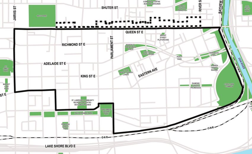
King-Parliament Secondary Plan Area Where you live
North Side of Queen Street East Study Area Where you work
WHAT IS THE DOWNTOWN PLAN?

• The Downtown Plan (OPA 406) brings forward a
  comprehensive policy framework to shape growth in
  Toronto’s Downtown over the next 25 years. It is the
  result of the four-year TOcore: Planning Downtown
  study.

• The Downtown Plan is a response to rapid growth,
  with projections showing a potential doubling of
  the Downtown population and a near-doubling of
  employment to 2041.

• The Downtown Plan provides the City with a blueprint
  to manage growth, sustain liveability, achieve complete
  communities and ensure there is space for the                            33%             51%                        25%                38%             40%                3%
  economy to grow.
                                                                                                                                      RESIDENTIAL   NON-RESIDENTIAL
                                                                           JOBS            GDP                     TAX BASE                                               LAND AREA
                                                                                                                                      DEVELOPMENT    DEVELOPMENT
• The Downtown Plan was adopted by City Council
  in May 2018 and was submitted to the Minister of
  Municipal Affairs and Housing in August 2018 for
  approval.

                                                            2011            2016                 2041                          2011                   2016                   2041
The King-Parliament Secondary Plan falls within the         432,900 jobs    502,100 jobs         850,000 -
                                                                                                 915,000 jobs
                                                                                                                               199,000
                                                                                                                               census population
                                                                                                                                                      238,000
                                                                                                                                                      census population
                                                                                                                                                                             475,000
                                                                                                                                                                             projected population
boundaries of the Downtown Plan. These two plans                                                 (including South of Eastern
                                                                                                 and Liberty Village)

will work together to provide guidance on how
                                                            13,800+ new jobs                                                   7,500+ new residents
King-Parliament will continue to grow.                      Downtown per year (2011-2016)                                      Downtown per year (2011-2016)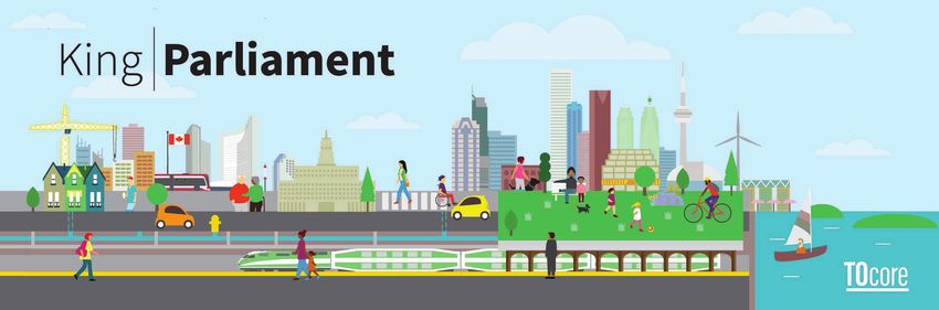
TIMELINES

                   2018                                                          2019                                                       2020
King-Parliament Secondary Plan Review

                                                                  Area Backgrounders       Proposed Secondary          Recommended Secondary Plan and Staff
                                                                    Published online      Plan and Staff Report at          Report at TEYCC/ Council
                                                                      March 2019             TEYCC/ Council                         April 2020
                                                                                               October 2019

Public Consultation

                                    Heritage           Heritage                 Built Form KP Pop-Up                 Open House #3   Statutory Public Meeting
                                    Focus Group #1     Focus Group #2           Workshop June 2019                   November 2019          April 2020
                                    December 2018                               April 2019
                                                       Open House #1
                                                       January 2019     are
                                                                      We e!                    Ongoing Stakeholder Engagement
                                                                       her

Downtown Plan (TOcore)

 Approved by Council                                               Decision anticipated by Province
      July 2018                                                              March 2019

Distillery District Heritage Conservation District Plan

                                                                                 Study Initiation
                                                                                 Summer 2019
St Lawrence Neighbourhood Heritage Conservation District Plan

                                                                                                                 LPAT Hearing
                                                                                                                November 2019
                      Possibility of LPAT* Appeal/Hearing (*Local Planning Appeal Tribunal)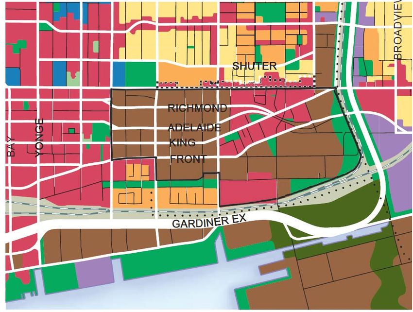
TRENDS
RESIDENTIAL AND EMPLOYMENT GROWTH

                13,267                                     14,383                                                       Residential
                people living in the                       people working in the
                Study Area                                 Study Area

                                                                                                                                                                         13,267

                                                                                                                                                                8,076
                                                                                                                                                     6,012

                                                                                                     Population
        increase in population between              increase in employment                                                                  3,980
        1991-2016                                   between 1991-2016                                                              2,457
 625%    # of residents in 1991: 1,829       15%    # of employees in 1991: 10,968
                                                                                                                          1,829

• The number of people who live                                                                                             1991     1996     2001      2006     2011       2016
                                                                                                                                                      Year
  and work in the King-Parliament
                                          Employment by Sector, 2017
  area has increased since 1996,                                                                                        Employment
  with over 10,000 new residents                           Office
                                                           57%
  and 4,500 more jobs.
• Between 2011 and 2016, the               Retail                                    Institutional
                                           8%                                             16%                                                                                   14,383
  number of people living in the                                                                                                            12,165
                                                                                                                                                                11,557
  area increased by 64%.                                                                                                  10,849
                                                                                                                                                                         12,460

                                                                                                      Total Employees
• The number of people living            Other
                                                                                         Service                                   9,848               9,215
                                          5%
  in the area is now almost the                                                           13%
  same as the number of people
  working in the area.                              Manufacturing                                                         1991      1996     2001      2006     2011     2016     2017
                                                        1%                                                                                           Year
• The office sector accounts for
  approximately 57% of all jobs in
  the King-Parliament area.                                                                                             Data Sources
                                                                                                                        Toronto Employment Survey, 1991- 2017
                                                                                                                        Statistics Canada, Census 2001- 2016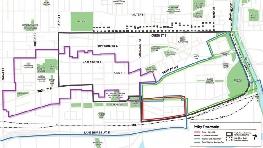
TRENDS
 DEVELOPMENT PIPELINE

Active Projects between
July 1, 2013 and
December 31, 2018

   UNDER REVIEW
   Projects under review have
   not yet been approved or
   refused by City Council or
   are under appeal to the
   Local Planning Appeal
   Tribunal (LPAT).

   ACTIVE
   Active projects are those
   which have been approved.
   They may or may not be
   under construction.

   BUILT
   Built projects are those
   which are ready for
   occupancy or are fully
   occupied.

                                Source: IBMS-Land Use Information System II, January 2019
                                Prepared by: Toronto City Planning Division, Research and Information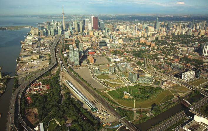
EXISTING PLANNING FRAMEWORKS

King-Parliament Secondary Plan Area                                    Central Waterfront Secondary Plan
The Secondary Plan and related Urban Design Guidelines                 The Central Waterfront Secondary Plan covers Toronto’s
were adopted in 1996 to encourage a mix of uses that                   waterfront and extends into the West Don Lands, which
reinforce the historic built form and public realm.                    also fall within the King-Parliament Secondary Plan.

  St. Lawrence Neighbourhood Heritage
  Conservation District                                       Distillery District Heritage Conservation District
  The St. Lawrence Neighbourhood Heritage Conservation        A Heritage Conservation District Study was completed for
  District (HCD) was designated by Council in 2015. A Local   the Distillery District in 2016. The HCD planning process
  Planning Appeal Tribunal (LPAT) hearing is scheduled for    will get underway in mid-2019.
  the HCD in November 2019.
LAND USE DESIGNATIONS
Map 18 of the Toronto Official Plan includes the in-force land use designations for the King-Parliament Area. Large portions of
the area are designated Regeneration Areas.

                                                                                                   REGENERATION AREAS

                                                                                             Regeneration Areas provide for a
                                                                                             broad mix of commercial, residential,
                                                                                             light industrial, parks and open space,
                                                                                             institutional and utility uses. This wide
                                                                                             array of uses is permitted in underused
                                                                                             areas of the City to help attract
                                                                                             investment, re-use buildings, encourage
                                                                                             new construction and bring life to the
                                                                                             streets.

                                                                                                   MIXED USE AREAS

                                                                                             Mixed Use Areas are made up of a
                                                                                             broad range of commercial, residential
                                                                                             and institutional uses, as well as parks
                                                                                             and open spaces and utilities. These
                                                                                             uses can be mixed within a broader
                                                                                             area, or within individual buildings.

                                                                                                   PARKS & OPEN SPACE AREAS

                                                                                              Parks and Open Space Areas are the
                                                                                              parks, open spaces, valleys, watercourses
                                                                                              and ravines that make up a green open
                                                                                              space network. Development is generally
                                                                                              prohibited in these areas except for
                                                                                              recreational and cultural facilities, public
                                                                                              transit and other essential infrastructure.
FOUR NEW MIXED USE AREAS
Regeneration Areas to Mixed Use Areas
Avenue
The Downtown Plan includes four new Mixed Use Areas designations. The
majority of Regeneration Areas in the King-Parliament area have been Dupont
redesignated to Mixed Use Areas to reflect redevelopment and renewal in
St George
Spadina
y Parkway
the area over the years.
Bathurst St
Bedford
Don Valle
MIXED USE AREAS 1 - GROWTH
Bloor
Mixed Use Areas 1 contains areas with the greatest heights and largest
Yonge
Bay
proportion of non-residential uses. These areas will experience the greatest
Parliament
Sherbourne
amount of intensification. King-Parliament does not include Mixed Use Areas 1.
Hoskin
Jarvis
Harbord
MIXED USE AREAS 2 - INTERMEDIATE Wellesley
Development within Mixed Use Areas 2 will include buildings that respond
to their site context including low-rise, midrise and some tall buildings. This College
Carlton
intermediate or “in-between” scale of development will provide a transition from
taller buildings in Mixed Use Areas 1 and the mid-rise character of Mixed Use Gerrard
Bayview
Church
Areas 3.
River
University
Broadview
MIXED USE AREAS 3 - MAIN STREET Dundas
Mixed Use Areas 3 will have a main street character and include a diversity of Shuteer
Shuter
uses in the form of low-rise and mid-rise buildings. These areas are generally
Queen
along surface transit corridors, often contain a large number of heritage Richmond
York
buildings and are mostly located adjacent to low-rise neighbourhoods. Adelaide
John
King
MIXED USE AREAS 4 - LOCAL Fr ont
ron
Fro
FFront
Wellington
Front
Mixed Use Areas 4 contains a mix of uses with a prevailing
character of house form and other types of low-rise buildings. Downtown Plan Boundary
aard
ar
Gard
Gardiner
Ga
G er
ner
ine
ddiner
rrdi
They are generally located off of main streets, embedded within
Quay
Queens
Mixed Use Areas 1 - Growth
the neighbourhood fabric.
ers
ission
Mixed Use Areas 2 - Intermediate
Comm
Mixed Use Areas 3 - Main Street
Cherry
Mixed Use Areas 4 - Local
Central Waterfront Secondary Plan Toronto Inner Harbour Not to Scale
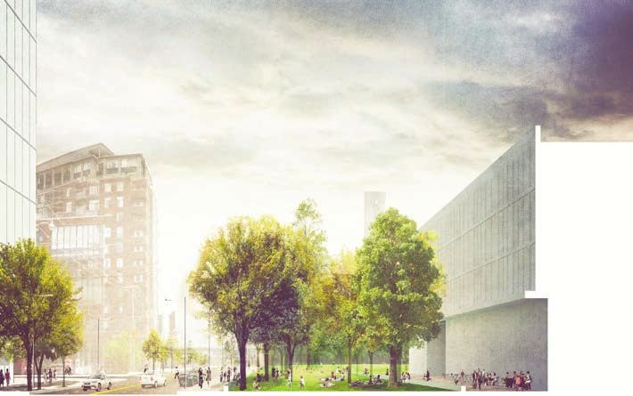
Downtown Plan Map 41-3: Mixed Use AreasDOWNTOWN PARKS & PUBLIC REALM PLAN Great Streets Park Districts A conceptual rendering of Parliament Street, looking south from the First Parliament site, showing enhanced tree-plantings, a dedicated An aerial image of the King-Parliament Secondary Plan area with Corktown Common in the foreground. bike lane and surface transit improvements. Downtown’s Great Streets have city-wide and civic A Park District is a cohesive local network of streets, importance with a diverse character that conveys Toronto’s laneways, parks and other open spaces centered on one public image to the world and sets the stage for festivals, or more community parks or open spaces that serve parades and civic life. The streets hold cultural and surrounding neighbourhoods. Each Park District will have a historical significance and provide connections to the Core unique identity with a focus on supporting community life. Circle - a continuous network of natural areas circling the Downtown. The Great Streets are destinations in themselves and will be prioritized for enhanced public realm improvements.
PARKS AND PUBLIC REALM STRUCTURE
DOWNTOWN PLAN
The Downtown Plan provides a parks and public realm structure for the entire Downtown, including the King-Parliament area.
GREAT STREET
These streets have city-
wide civic importance and
unique character.
SHUTER ST
BAYVIEW AVE
SUMACH - SHUTER
RIVER ST
JOEL WEEKS
PARKETTE PARK
GREAT STREET PARK
MOSS PA
P RK
INTERSECTION
These intersections are NS
QUEEN
QUE ST E
B
significant public spaces BRIGHT
HT
HT
STREET
that support public life. PLAYGROUND
TE
IS ST
T
RICHMOND ST
ST
POWER ST
CULTURAL CORRIDOR
ARVIS
VIS
- OPEN GREEN
SHERBOURNE
V
SPACE
These corridors support the E SACKVILLE
ST
JJAR
AR
PLAYGROUND
U UNDERPASS
ASS
S
DE
PERCY PARK
JA
culture sector and will have LAI
PARK
PAR
PA
enhanced public realm.
RB ADE
DON
ST
T. JAMES
ST. LIT E
LITTLE WRE
LAWREN
L AWREEN
PRIORITY RETAIL
P
PAARK
RK TRIN
TRINITY
N AVE RR
RIS
HARRIS
RR IS
TER
RIV
CH
CHURCH
C H LANDS SQUARE
QUA
ARE
STREET TE
NG ST
KING EAS
ER
These streets contribute
ENT ST
MARKET DIAMOND
AMON
MO
CORKTOWN
CORKTOWN
LANE JJUBILEE
UBILE
UBILE
JU E
EEE
to vibrant, walkable
MENT
COMMON
PAR
RK
RO
RO
FR
F
FRONNT
ONT
ON TE
T ST PROMENADE
neighbourhoods by
PARLIAM
animating the public realm
ST. LAWRENCE COMMUNITY
with active retail. RECREATION CENTRE -
PA
TRCA
CA
CA
BUILDING GROUNDS LANDS
DS
PARK DISTRICT
PARLIAMENT
PA RLI
RLIAMENT
SQUA
AMENT
SQUARE
ARE
RE C NR (51)
AV CROMBI
DAVID
DAV CROMBIE
CROMBIE PARK
A RK
ARK
PARK
PA RK
Park Districts connect
community parks and PRINCESS
STREET
open spaces to support PARK
CNR
community life.
CPR CNR
SUN-PROTECTED
PARK
LAKE SHORE BLVD E
LAKE SHO
RE BLVD E
King-Parliament Secondary Plan Review Study Area
North Side of Queen Street East Study Area i
These parks are protected SHERBOURNE COMMON
from additional shadow
from development.PARKS AND PUBLIC REALM STRUCTURE
OTHER EXISTING PLANS
A number of other existing plans provide direction for parks and public realm in the King- St. Lawrence Neighbourhood Heritage Conservation District Plan
Parliament area. These plans include important public realm elements that overlap. SHUTER ST
BAYVIEW AVE
SUMACH - SHUTER
RIVER ST
JOEL WEEKS
PARKETTE PARK
MOSS PARK
Through the King-Parliament Secondary Plan Review, we will streamline the many ideas
QUEEN ST E
included in existing plans to provide a clear direction on public realm improvements in the BRIGHT
STREET
PLAYGROUND
area. RICHMOND ST E
JARVIS ST
SHERBOURNE ST
POWER ST
- OPEN GREEN
SPACE
TE
SACKVILLE
S PLAYGROUND UNDERPASS
IDE
PERCY PARK
PARK
LA
King-Parliament Secondary Plan: The in-force Secondary Plan identifies significant ADE
DON
ST. JAMES LITTLE LAWREN
E
N AV
streets and open spaces, illustrates potential mid-block connections and notes locations
PARK TRINITY HARRIS
TER
RIV
CHURCH LANDS SQUARE
KING ST E EAS
ER
for streetscape improvement.
PARLIAMENT ST
MARKET DIAMOND
CORKTOWN
LANE JUBILEE
COMMON
PARK
FRONT ST E PROMENADE
ST. LAWRENCE COMMUNITY
St. Lawrence Neighbourhood Heritage Conservation District Plan: The HCD Plan RECREATION CENTRE -
BUILDING GROUNDS
R
TRCA
LANDS
CN
PARLIAMENT (51)
includes major streets and identifies many streets as Special Areas.
SQUARE
DAVID CROMBIE PARK
PARK
PRINCESS
STREET
PARK
CNR
St. Lawrence Market Neighbourhood BIA Public Realm Master Plan: The Master CPR CNR
Plan identifies locations for potential sidewalk widenings, potential new mid-block LAKE SHORE BLVD E
LAKE SHOR
E BLVD E
King-Parliament Secondary Plan Review Study Area
North Side of Queen Street East Study Area i
connections, special intersections, and potential locations for shared and/or pedestrian
SHERBOURNE COMMON
MAJOR STREET POPS
streets.
SPECIAL AREA
LANEWAY
St. Lawrence Market Neighbourhood BIA
King-Parliament Secondary Plan Public Realm Master Plan (produced by the BIA)
SHUTER ST SHUTER ST
AVE
BAYVIEW AVE
SUMACH - SHUTER SUMACH - SHUTER
RIVER ST
RIVER ST
JOEL WEEKS JOEL WEEKS
PARKETTE PARK PARKETTE PARK
BAYVIEW
MOSS PARK MOSS PARK
BAY
UEEN
QUEEN
Q TE
UEEN ST QUEEN ST E
BRIGHT BRIGHT
STREET STREET
PLAYGROUND PLAYGROUND
ON ST E RICHMOND ST E
VIS ST
T
JARVIS ST
RICHMOND
ST
N ST
POWER ST POWER ST
JARVIS
- OPEN GREEN - OPEN GREEN
SHERBOURNE
SHERBOURNE
ARV
SPACE SPACE
TE TE
VIL
ILL
SACKVILLE
KV SACKVILLE
*
JJAR
S PLAYGRO
OUN
PLAYGROUND UNDERPASS
S PLAYGROUND UNDERPASS
IDE IDE
PERCY PARK PERCY PARK
PARK PARK
LA LA
ADE ADE
H RB
DON
DON
SHER
ST. JAMES LITTLE
TTLE
TTLE
LITTLE LAWREN ST. JAMES LITTLE LAWREN
E E
N AV N AV
PARK T
TRINITY HARRIS PARK TRINITY HARRIS
TER TER
RIV
RIV
H URCH
CHURCH
HURCH H LAN
CH L
LAND
LANDS SQUARE CHURCH LANDS SQUARE
K TE
NG ST
IN
KING EAS KING ST E EAS
ER
ER
T
AMENT ST
T
PARLIAMENT ST
MARKET DIAMOND MARKET DIAMOND
CORKTOWN CORKTOWN
LANE JUBILEE LANE JUBILEE
PARLIAMENT
COMMON COMMON
PARK
R
ROONT
ON
FRONT
F TE
T ST PROMENADE PARK
FRONT ST E PROMENADE
ARLIA
ST. LAWRENCE COMMUNITY
NIT
NI TY
IT Y ST. LAWRENCE COMMUNITY
RECREATION CENTREE- RECREATION CENTRE -
PA
TRCA TRCA
BUILDING GROUNDS
S BUILDING GROUNDS
P
P
LANDS LANDS
R R
CN CN
PARLIAMENT
P
PAA
PARL
ARR
RLI
LIAME
IAME
AMEN
AMENT
NT (51) PARLIAMENT
PARLIAMEN
PA NT (51)
SQUARE E SQUARE
DAV
D AVID CROMBI
AV CROMBIE
CROMBIE P
PARK
ARK
PA DAVID CROMBIE PARK
P R
PA RK
K P
PARK
ARK
PA RK
PRINCESS PRINCESS
STREET STREET
PARK
CNR PARK
CNR
CPR CNR CPR CNR
LAKE SHORE BLVD E
LAKE SHOR
E BLVD E
King-Parliament Secondary Plan Review Study Area
North Side of Queen Street East Study Area i LAKE SHORE BLVD E
LAKE SHOR
E BLVD E
King-Parliament Secondary Plan Review Study Area
North Side of Queen Street East Study Area i
SHERBOURNE COMMON SHERBOURNE COMMON
SIGNIFICANT STREET & OPEN SPACE POTENTIAL BOULEVARD WIDENINGS POTENTIAL PEDESTRIAN “STREET” THROUGH PARK
POTENTIAL MID-BLOCK CONNECTION POTENTIAL NEW MID-BLOCK CONNECTION POTENTIAL SHARED/FLEX STREET
* AREA FOR STREETSCAPE IMPROVEMENT EXISTING MID-BLOCK CONNECTION SPECIAL INTERSECTIONYou can also read