Barrington Tops National Park, Mount Royal National Park and Barrington Tops State Conservation Area - NSW NATIONAL PARKS & WILDLIFE SERVICE ...
←
→
Page content transcription
If your browser does not render page correctly, please read the page content below
NSW NATIONAL PARKS & WILDLIFE SERVICE

Barrington Tops National Park,
Mount Royal National Park and
Barrington Tops State
Conservation Area
Draft Amendment to the Plan of Management

environment.nsw.gov.au
© 2021 State of NSW and Department of Planning, Industry and Environment
With the exception of photographs, the State of NSW and Department of Planning, Industry
and Environment are pleased to allow this material to be reproduced in whole or in part for
educational and non-commercial use, provided the meaning is unchanged and its source,
publisher and authorship are acknowledged. Specific permission is required for the
reproduction of photographs.
The Department of Planning, Industry and Environment (DPIE) has compiled this report in
good faith, exercising all due care and attention. No representation is made about the
accuracy, completeness or suitability of the information in this publication for any particular
purpose. DPIE shall not be liable for any damage which may occur to any person or
organisation taking action or not on the basis of this publication. Readers should seek
appropriate advice when applying the information to their specific needs.
All content in this publication is owned by DPIE and is protected by Crown Copyright, unless
credited otherwise. It is licensed under the Creative Commons Attribution 4.0 International
(CC BY 4.0), subject to the exemptions contained in the licence. The legal code for the
licence is available at Creative Commons.
DPIE asserts the right to be attributed as author of the original material in the following
manner: © State of New South Wales and Department of Planning, Industry and
Environment 2021.
Cover photo: Barrington Tops State Conservation Area. Barry Collier/DPIE

Published by:
Environment, Energy and Science
Department of Planning, Industry and Environment
Locked Bag 5022, Parramatta NSW 2124
Phone: +61 2 9995 5000 (switchboard)
Phone: 1300 361 967 (Environment, Energy and Science enquiries)
TTY users: phone 133 677, then ask for 1300 361 967
Speak and listen users: phone 1300 555 727, then ask for 1300 361 967
Email: info@environment.nsw.gov.au
Website: www.environment.nsw.gov.au
Report pollution and environmental incidents
Environment Line: 131 555 (NSW only) or info@environment.nsw.gov.au
See also www.environment.nsw.gov.au
ISBN 978-1-922493-99-6
EES 2021/0039
February 2021

Find out more about your environment at:

www.environment.nsw.gov.au
Contents
Have your say                                                        1
    What happens to your feedback?                                    1
    Your privacy                                                      1
Why amend the plan?                                                  2
    Improvements to visitor facilities and management                 2
    Updates required for currency                                     3
How to read the amendment                                            3
Proposed amendments                                                  4
    1.   Improving visitor facilities at camping and day use areas    4
    2.   Updates required for currency                                8
References                                                           14

                                        iii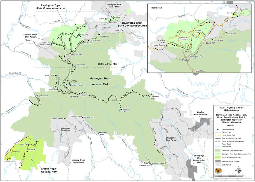
List of tables
Table 1 Camping area facilities 5
Table 2 Day use facilities 6
List of figures
Figure 1 Figure 5 Seasonal Road Closures in the Planning Area 7
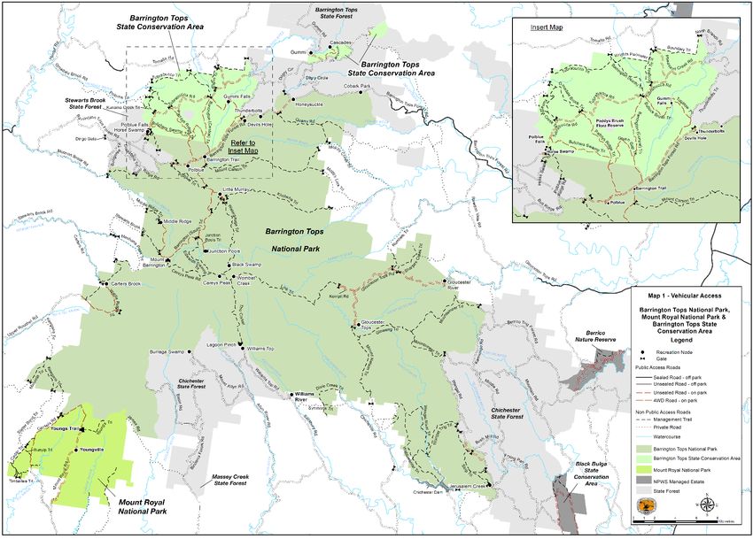
Figure 2 Map 1 Vehicular Access 9
Figure 3 Map 2 Recreational Facilities 10
Figure 4 Map 3 Cycling and Horse Riding 11
iv
Have your say
We want to know what you think about this draft plan amendment. To give us feedback,
please send a written submission via:
      the online submission form at www.environment.nsw.gov.au/get-involved/have-your-
      say
      email to npws.parkplanning@environment.nsw.gov.au
      post to Manager, Planning Evaluation and Assessment, Locked Bag 5022, Parramatta
      NSW 2124.
Written submissions must be received by 22 March 2021.
To help us make the best use of your feedback:
•   Please tell us what issue or part of the amendment you are talking about. One way you
    can do this is to include the section heading and/or page number from the amendment
    in your submission.
•   Tell us how we can make the amendment better. You may want to tell us what you know
    about the park or how you or other people use and value it.
We are happy to hear any ideas or comments and will consider them all, but please be
aware that we can’t always include all information or ideas in the final plan.

What happens to your feedback?
Step 1:   At the close of the public exhibition period, we consider all submissions and
          prepare a submissions report. Multiple submissions received by the same author
          will be counted as a single submission.
Step 2:   We provide the relevant local advisory committee and the National Parks and
          Wildlife Advisory Council with the draft plan, all the submissions and the
          submissions report. They consider the documents, make comments on the plan or
          suggest changes, and provide advice to the Minister for Energy and Environment.
Step 3:   The Minister considers the plan, submissions and advice, makes any necessary
          changes and decides whether to adopt the plan under the National Parks and
          Wildlife Act 1974.

Your privacy
Your submission will be provided to two advisory bodies. Your comments on the draft plan
may include personal information. The Department of Planning, Industry and Environment
complies with the NSW Privacy and Personal Information Protection Act 1998, which
regulates the collection, storage, quality, use and disclosure of personal information. For
details see Privacy and security.
Information that identifies you may be gathered when you use our website or send us an
email. If you indicate in your written submission that you object to your submission being
made public, we will ask you before releasing your submission in response to any access
applications under the Government Information (Public Access) Act 2009.

                                              1
Why amend the plan?
Plans of management are legal documents that are prepared, in consultation with the
community, as outlined in Part 5 of the National Parks and Wildlife Act 1974. Once a plan of
management is adopted by the Minister for Energy and Environment, operations in a park
must be carried out in accordance with the plan.
The Barrington Tops National Park, Mount Royal National Park and Barrington Tops State
Conservation Area Plan of Management was adopted in 2010. Section 73B of the National
Parks and Wildlife Act enables the Minister to amend a plan of management.
The proposed changes to the Barrington Tops National Park, Mount Royal National Park
and Barrington Tops State Conservation Area Plan of Management will enable:
• improvements to visitor facilities and management at camping and day use areas
• improvements to walking tracks
• updates to park information for currency.
Improvements to visitor facilities and management
In 2018, Barrington Tops National Park received an estimated 120,000 visits. Visitation to
the park continues to increase.
Gummi Falls camping and day use area receives an estimated 3000 visits per annum, which
exceeds the capacity of existing visitor facilities. Competition for space, overflow bush
camping and driving off-trail has negatively impacted native plants, the adjacent Manning
River and the visitor experience. Existing outdated toilet facilities pose a safety risk to staff
and visitors.
The proposed upgrades to the Gummi Falls camping and day use area will enhance the
visitor experience, improve camping amenity and reduce safety risks to staff and visitors,
maintenance requirements and adverse impacts on the park’s significant values. Visitor and
vehicle movements into sensitive areas next to the river will be restricted.
Improvements to visitor facilities at several other camping and day use areas and walking
tracks across the parks are also proposed, subject to economic feasibility, to enhance the
visitor experience, manage increasing demand for visitor facilities and recreation
opportunities and reduce impacts to park values.
Amendments to the plan will additionally enable:
• provision of additional camping sites and visitor facilities at Gummi Falls, Youngville,
Little Murray, Junction Pools and Devils Hole camping areas
• year-round entry to Gummi Falls camping area, subject to access upgrade
• provision of additional visitor facilities at Polblue Falls, Williams Top, Gummi, Williams
River and Lagoon Pinch day use areas
• development and implementation of a walking track strategy for Mount Royal National
Park
• inclusion of facilities that have been established, in line with the plan, at Youngville,
Cobark Park and Jerusalem Creek and removal of outdated or completed visitor
infrastructure actions from the plan.
2Updates required for currency
The proposed amendment to the plan will also:
• correct trail names (on maps and in text)
• correct map symbology
• remove reference to pigs in Mount Royal National Park
• correct the Pieries Peak walking trail classification.
How to read the amendment
The proposed amendment, if adopted, would change the Barrington Tops National Park,
Mount Royal National Park and Barrington Tops State Conservation Area Plan of
Management and should read in conjunction with the adopted plan. Section numbers
referred to in the amendment refer to the adopted plan of management.
3Proposed amendments
The following changes are proposed to the Barrington Tops National Park, Mount Royal
National Park and Barrington Tops State Conservation Area Plan of Management (NPWS
2010).
1. Improving visitor facilities at camping and day use
areas
Section 9.3 Camping
Plan reference: page 61, under Guidelines
Add:
9.3.4b Configure and manage facilities in camping areas in accordance with Table 2.
Section 12. Implementation and review of plan
Plan reference: page 96, Table 6: Summary of Guidelines, under 9.3 Camping
Add:
9.3.4b Configure and manage facilities in camping areas in accordance with Table 2.
Section 9.4 Day Use
Plan reference: page 63, under Guidelines
Add:
9.4.2b Configure and manage facilities in day use areas in accordance with Table 3.
Section 9.5 Walking tracks
Plan reference: page 67, under Actions
Add:
9.5.12 Develop and publicly exhibit a Mount Royal National Park Walking Track Strategy.
Establish and maintain walking tracks and visitor facilities in line with the strategy, subject to
environmental assessments and economic feasibility. Review and update the strategy as
required.
Section 12. Implementation and review of plan
Plan reference: page 96, Table 6: Summary of Guidelines, under 9.4 Day Use
Add:
9.4.2b Configure and manage facilities in day use areas in accordance with Table 3.
4Plan reference: page 61, Table 2
Replace Table 2 with:
Table 1 Camping area facilities
Designated
2WD vehicular access
4WD vehicular access
Camping Maximum number of
Woodfires permitted
trailers permitted (2)
Communal fireplace
Information panels /
Area
caravans/camper
Large Caravans /
in fireplaces (3)
Horse camping
Toilet facilities
campsites (1)
Campervans
Gas BBQs
permitted
permitted
shelter
Tables
Small
(4)
Polblue 60 Y Y Y Y Y Y Y Y Y
Polblue 5 Y N Y P
Overflow
Gloucester 25 Y Y Y Y Y Y P Y Y
River
Gloucester 5 Y N Y Y
River
Overflow
Horse 8 Y Y Y Y P Y Y
Swamp
Devils Hole 5 Y N Y P Y
Youngville 4 Y Y Y Y Y Y
Cascades 3 Y Y P
Little Murray 10 Y N Y Y Y Y
Junction 10 Y N Y Y
Pools
Gummi Falls 20 Y N Y Y P P Y
Wombat 5 Y Y
Creek
(remote,
walking
access only)
Black 5 P Y
Swamp
(remote,
walking
access only)
Y - facility provided, P - facility proposed, N – not permitted
1 - Campsites at camping areas with vehicle access will accommodate 6 people and campsites at camping
areas with walking access only will accommodate 2 people
2 – Infrastructure (roads, vehicle parking and turning bays) will not accommodate large caravans
3 - Fireplaces may be shared between multiple campsites
4 - Communal fireplaces are larger fireplaces associated with shelter infrastructure.
5Section 9.4 Day Use
Plan reference: page 65, Table 3
Replace Table 3 with:
Table 2 Day use facilities
Designated
Woodfires permitted in
Day Use Area
2WD vehicular access
4WD vehicular access
Information panels /
Lookout/viewing
Disabled access
Toilet facilities
Gas BBQs
fireplaces
platform
shelter
Tables
Gloucester Y Y Y Y Y
Tops
Polblue Y Y Y Y Y Y
Honeysuckle Y Y Y Y
Devils Hole Y Y Y Y Y Y Y
Williams River Y Y Y Y Y Y Y
Cobark Park Y P Y Y P
Youngville Y Y Y Y Y Y
Gloucester Y Y Y Y Y Y
River
Thunderbolts Y Y
Lookout
Jerusalem Y Y Y Y Y Y
Creek
Polblue Falls Y Y
Barrington Trail Y Y Y
Lagoon Pinch Y Y Y
Williams Top Y Y Y
Burraga Swamp Y P P
Gummi Y Y Y
Gummi Falls Y Y P P P
Youngs Trail Y Y Y
Mount Y P P P P
Barrington
Middle Ridge Y P
Carters Brook Y P
Careys Peak Y
Y – facility provided, P – facility proposed
6Plan reference: Figure 5, page 56
Replace Figure 5 with:
Figure 1 Figure 5 Seasonal Road Closures in the Planning Area
72. Updates required for currency
Proposed changes
Maps and figures
Maps 1 – 3 have been corrected to reference the Gummi Road and Wombat Trail (both
referred to as the Gummi Trail in the adopted plan of management) and to remove a road
that does not exist (north of Cascades).
Map 3 has been corrected to illustrate horse riding access to Cascades via Wombat Trail
(permitted but not symbolised in the adopted plan of management).
8Plan reference: Map 1, page 117
Replace Map 1 with:
Figure 2 Map 1 Vehicular Access
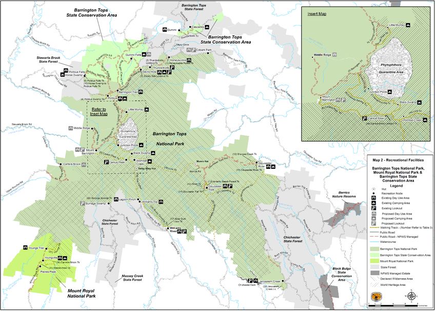
9Plan reference: Map 2, page 118
Replace Map 2 with:
Figure 3 Map 2 Recreational Facilities
10Plan reference: Map 3, page 119
Replace Map 3 with:
Figure 4 Map 3 Cycling and Horse Riding
11Barrington Tops National Park, Mount Royal National Park and Barrington Tops State Conservation Area
Proposed Amendment to the Plan of Management
Section 7.2 Introduced Animals
Plan reference: page 43, below the sixth paragraph
Delete:
There have been no recordings of feral pigs in Mount Royal National Park.
Section 9.2 Vehicle Access
Plan reference: page 58, under Guidelines
Replace:
9.2.1 Maintain the public and park roads illustrated on Map 1 (pg. 120) for two and four-
wheel drive access. This provides 75km of roads available for unsealed two-wheel drive
access and 59 kilometres for four-wheel drive access.
With:
9.2.1 Maintain the public and park roads illustrated on Map 1 (pg. 120) for two and four-
wheel drive access. This provides 75 kilometres of roads available for unsealed two-wheel
drive access and 61 kilometres for four-wheel drive access.
Section 12. Implementation and review of plan
Plan reference: page 96, Table 6: Summary of Guidelines, under 9.2 Vehicle Access
Replace:
9.2.1 Maintain the public and park roads illustrated on Map 1 (pg. 120) for two and four-
wheel drive access. This provides 75km of roads available for unsealed two-wheel drive
access and 59 kilometres for four-wheel drive access.
With:
9.2.1 Maintain the public and park roads illustrated on Map 1 (pg. 120) for two and four-
wheel drive access. This provides 75 kilometres of roads available for unsealed two-wheel
drive access and 61 kilometres for four-wheel drive access.
Section 9.5 Walking tracks
Plan reference: page 68, Table 4
Replace:
No. Walking Track Distance Current Proposed
Standard Standard
25 Mount Royal: Pieries Peak Walking track 2.6km Marked Route Marked Route
return (Class 5) (Class 5)
With:
No. Walking Track Distance Current Proposed
Standard Standard
25 Mount Royal: Pieries Peak Walking track 2.6km Marked Route Hiking Track
return (Class 5) (Class 4)
12Barrington Tops National Park, Mount Royal National Park and Barrington Tops State Conservation Area
Proposed Amendment to the Plan of Management
Section 9.6 Horse Riding
Plan reference: page 70, first paragraph
Replace:
9.6.1 Horse riding will be permitted in Barrington Tops State Conservation Area on the
Bicentennial National Trail along Tubrabucca Road, Butchers Swamp Trail, Paddys Ridge
trail, Green Gap Trail, Barrington Trail, Pheasant Creek Road and Gummi Trail; and on
Tubrabucca Road, Bullock Brush Trail, Tugalow Trail, Thunderbolts Trail and Gummi Trail;
and in Mount Royal National Park on Mount Royal Road, Cassels Road and Cedar,
Timberlea and Bunyip trails. Horses will only be permitted within the road corridor of all these
designated trails as shown on Map 3.
With:
9.6.1 Horse riding will be permitted in Barrington Tops State Conservation Area on the
Bicentennial National Trail along Tubrabucca Road, Butchers Swamp Trail, Paddys Ridge
trail, Green Gap Trail, Barrington Trail – Central, Pheasant Creek Road and Gummi Road;
and on Tubrabucca Road, Bullock Brush Trail, Tugalow Trail, Thunderbolts Trail and
Wombat Trail; and in Mount Royal National Park on Mount Royal Road, Cassels Road and
Cedar, Timberlea and Bunyip trails. Horses will only be permitted within the road corridor of
all these designated trails as shown on Map 3.
Section 12. Implementation and review of plan
Plan reference: page 96, Table 6: Summary of Guidelines, under 9.6 Horse riding
Replace:
9.6.1 Horse riding will be permitted in Barrington Tops State Conservation Area on the
Bicentennial National Trail along Tubrabucca Road, Butchers Swamp Trail, Paddys Ridge
trail, Green Gap Trail, Barrington Trail, Pheasant Creek Road and Gummi Trail; and on
Tubrabucca Road, Bullock Brush Trail, Tugalow Trail, Thunderbolts Trail and Gummi Trail;
and in Mount Royal National Park on Mount Royal Road, Cassels Road and Cedar,
Timberlea and Bunyip trails. Horses will only be permitted within the road corridor of all these
designated trails as shown on Map 3.
With:
9.6.1 Horse riding will be permitted in Barrington Tops State Conservation Area on the
Bicentennial National Trail along Tubrabucca Road, Butchers Swamp Trail, Paddys Ridge
trail, Green Gap Trail, Barrington Trail – Central, Pheasant Creek Road and Gummi Road;
and on Tubrabucca Road, Bullock Brush Trail, Tugalow Trail, Thunderbolts Trail and
Wombat Trail; and in Mount Royal National Park on Mount Royal Road, Cassels Road and
Cedar, Timberlea and Bunyip trails. Horses will only be permitted within the road corridor of
all these designated trails as shown on Map 3.
13Barrington Tops National Park, Mount Royal National Park and Barrington Tops State Conservation Area
Proposed Amendment to the Plan of Management
References
NPWS 2010, Barrington Tops National Park, Mount Royal National Park, and Barrington
Tops State Conservation Area Plan of Management, NSW National Parks and Wildlife
Service, accessed 29 July 2020,
https://www.environment.nsw.gov.au/-/media/OEH/Corporate-Site/Documents/Parks-
reserves-and-protected-areas/Parks-plans-of-management/barrington-tops-mount-royal-
national-parks-barrington-tops-sca-plan-of-management-1008.pdf
14You can also read