East of Haig Fras Marine Conservation Zone - Site Summary Document Designated: November 2013
←
→
Page content transcription
If your browser does not render page correctly, please read the page content below
East of Haig Fras Marine
  Conservation Zone
     Site Summary Document

     Designated: November 2013

                 Dogfish with coarse sediments © JNCC & Cefas

             Version 4.0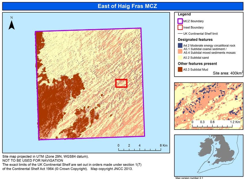
Produced by JNCC                                                                                 November 2013

Background
The UK Government and the Devolved Administrations are committed to establishing an
ecologically coherent network of Marine Protected Areas (MPAs) in the UK seas to meet
international commitments and European obligations. The Marine and Coastal Access Act (2009)
(as amended), Marine (Scotland) Act (2010) and Marine (Northern Ireland) Act (2013) place a
requirement on the UK Governments to create a network of MPAs that will comprise existing sites
(European Marine Sites, SSSIs and Ramsar sites) together with new national designations. The
Marine and Coastal Access Act makes provision for the designation of Marine Conservation
Zones (MCZs) in the UK Marine Area apart from Scottish and Northern Irish inshore waters 1;
MCZs will be called Marine Protected Areas in Scottish Offshore Waters. Together the network
will protect the range and diversity of marine features found in UK waters (Section 123) 2.

The UK Government’s Department of Food, Environment & Rural Affairs (Defra) commissioned
the Joint Nature Conservation Committee (JNCC) and Natural England to identify and
recommend MCZs in English nearshore waters, and UK offshore waters around England,
Northern Ireland and Wales. Together with the existing MPAs, these recommended MCZs would
enable the UK Government to meet its obligations towards achieving a MPA network.

JNCC and Natural England established four regional MCZ project groups 3 who worked with
stakeholders (sea users, regulators and interest groups) to identify MCZs. In September
2011 the Regional MCZ Projects submitted their recommendations to JNCC and Natural
England 4. These recommendations were reviewed by an independent Science Advisory Panel,
and then further assessed by JNCC and Natural England who provided their formal scientific
advice to Defra in July 2012. Defra reviewed the scientific advice alongside socio-economic
information and undertook a public consultation on the recommended MCZs between December
2012 and March 2013. Defra put forward 31 of the original 127 recommendations for potential
designation. After reviewing the responses to the public consultation, Defra designated 27 MCZs
in November 2013.

East of Haig Fras was recommended by the Finding Sanctuary Regional MCZ Project, and was
one of the 31 sites proposed for designation as a MCZ in 2013. Following the public consultation,
Defra confirmed its intention to progress the site and East of Haig Fras MCZ was designated in
November 2013.

Purpose of Document

The present document provides information about East of Haig Fras MCZ, including basic
information on its location, the site main characteristics and a description of the features
protected under Section 117 of the Marine and Coastal Access Act 2009 (as amended) 5.

The scientific information provided in this document was used by Defra to designate the MCZ 6,
for the purpose of conserving marine flora or fauna, marine habitats or types of marine habitat,
and features of geological or geomorphological interest. This document does not provide advice
on conservation management. JNCC will separately issue formal conservation advice to meet its
obligation under Section 127 of the Marine and Coastal Management Act 2009 (as amended) 7.

1
  The Marine (Scotland) Act and Marine (Northern Ireland) Act make provision for Marine Protected Areas in Scottish
inshore waters and Marine Conservation Zones in Northern Irish inshore waters.
2
  http://www.legislation.gov.uk/ukpga/2009/23/section/123
3
  MCZ regional project information: http://jncc.defra.gov.uk/page-2409
4
  MCZ regional project recommendations: http://jncc.defra.gov.uk/page-6228
5
  Section 117 Marine & Coastal Access Act 2009: http://www.legislation.gov.uk
6
  Designation order: https://www.gov.uk/government/publications
7
  Section 127 Marine & Coastal Access Act 2009: http://www.legislation.gov.uk/ukpga/2009/23/2010-01-12

East Haig Fras Site Summary Document.docx                                                       jncc.defra.gov.uk
                                                        2
Produced by JNCC                                                                    November 2013

Version Control
Version     Date            Amendments made                                     Author(s)
V1.0        22/07/2013      Creation of document for East of Haig Fras MCZ      NT
V2.0        16/09/2013      Draft version submitted to JNCC MPA Sub Group for   OP
                            independent review
V3.0        14/10/2013      Final draft version                                 NT
V4.0        08/11/2013      Final published version                             NT

This document is available for download from JNCC’s website at: jncc.defra.gov.uk

Please return queries to:

Marine Protected Sites
Joint Nature Conservation Committee
Monkstone House
Peterborough
Cambridgeshire
PE1 1JY

Email: mczs@jncc.gov.uk
Tel: +44 (0)1733 562626
Fax: +44 (0)1733 555948
Website: jncc.defra.gov.uk/marineprotectedareas

Cite as: JNCC (2013) MCZ Site Summary Document: East of Haig Fras MCZ. Version 4.0,
November 2013. JNCC, UK. Available from: (jncc.defra.gov.uk/marineprotectedareas).

                             Burrowing megafauna on sandy substrate © JNCC & Cefas

East Haig Fras Site Summary Document.docx                                       jncc.defra.gov.uk
                                                3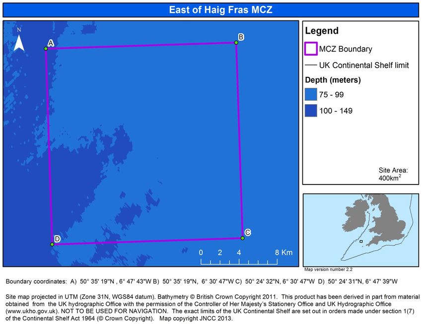
Produced by JNCC                                                                                      November 2013

East of Haig Fras MCZ: Site Summary Document
1. Site name
East of Haig Fras MCZ

2. Site location
The coordinates for the site boundary are based on the WGS84 Datum:
 A                      B                      C                  D
    50° 35’ 19”N, 6° 47’ 43”W   50° 35’ 19”N, 6° 30’ 47”W   50° 24’ 32”N, 6° 30’ 47”W   50° 24’ 31”N, 6° 47’ 39”W

East of Haig Fras MCZ is located in UK offshore waters of the Celtic Sea between the UK and
the Republic of Ireland. The south-east corner of the site is approximately 67km from the Land’s
End peninsula, south-west England. The site covers an area of approximately 400 km2
(calculated in ETRS89 LAEA) (see Map 1).

3. Site boundary
Finding Sanctuary Regional MCZ Project 8 recommended East of Haig Fras MCZ, which was
then assessed by the Statutory Nature Conservation Bodies (SNCBs) and subject to public
consultation by Defra, between December 2012 and March 2013. The final site boundary is the
same as that originally recommended by Finding Sanctuary.

It is important to note that the boundary depicts the MCZ designation itself. Any future
management measures that may be required to deliver the conservation objectives will be
determined by the appropriate Public Authorities in consultation with JNCC, and may have
different delimitations within the MCZ site boundary

4. Site bathymetry
Min depth: 50m, Max depth: 100m (approximately) below chart datum. The site lies on the
continental shelf where the site bathymetry ranges between 50m and 100m below sea level.
Small areas in the western end of the site dip below 100m in depth.

5. Biogeographic region
JNCC regional sea: Western Channel & Celtic Sea. OSPAR Region III: Celtic Waters

6. Designated Features of East of Haig Fras MCZ
                     Feature                            Feature Type             General Management Approach
                                                9
A4.2 Moderate energy circalittoral rock              Broad-Scale Habitat       Recover to Favourable Condition
                               10
A5.1 Subtidal coarse sediment / A5.4
                           11                        Broad-Scale Habitat       Recover to Favourable Condition
  Subtidal mixed sediments mosaic
                            12
         A5.2 Subtidal sand                          Broad-Scale Habitat       Recover to Favourable Condition

See Map 2 for further detail of the designated feature distribution. Note that the inset map
shows how the three designated features are intermixed at a detailed spatial scale creating a
complex habitat mosaic.

8
 Archived regional project webpage: http://jncc.defra.gov.uk/page-6230-theme=default
9
  MCZ Features Catalogue: http://jncc.defra.gov.uk/page-5798
10
   MCZ Features Catalogue: http://jncc.defra.gov.uk/page-5801
11
   MCZ Features Catalogue: http://jncc.defra.gov.uk/page-5800
12
   MCZ Features Catalogue: http://jncc.defra.gov.uk/page-5803

East Haig Fras Site Summary Document.docx                                                            jncc.defra.gov.uk
                                                            4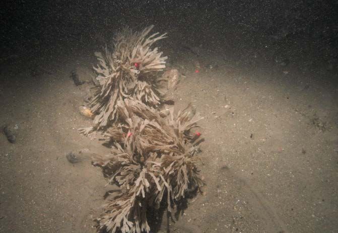
Produced by JNCC                                                              November 2013

7. Site maps

                                          Map 1: Location and Bathymetry of East of Haig Fras MCZ

East Haig Fras Site   Summary Document.docx                                  jncc.defra.gov.uk      jncc.defra.gov.uk
                                                                    5
Produced by JNCC                                                                     November 2013

                                               Map 2: Designated Features of East of Haig Fras MCZ
              The red rectangle relates to the inset map section showing the detail of how the three broad-scale habitats are distributed

East Haig Fras Site   Summary Document.docx                                         jncc.defra.gov.uk                                jncc.defra.gov.uk
                                                                          6
Produced by JNCC November 2013
Detailed site information
Site Description
Finding Sanctuary MCZ Regional Project identified the site using a map showing the predicted
distribution of EUNIS13 broad-scale habitats from the UK SeaMap Project (McBreen, 2010). It
comprises a simple rectangle with boundaries aligned north–south and east–west. The site is
on a plateau, with the most common depths ranging from 80m to 100m below chart datum
(Eggleton and Downie, 2013).
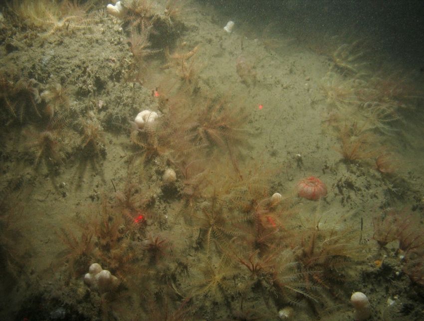
East of Haig Fras MCZ is a complex mixture of habitats including rock, mud, sand and mixed
sediments. These broad-scale habitats are all found throughout the site in varying abundance.
The north-west quarter of the site is predominantly sandy with more coarse sediments
appearing in the southern half of the site. Rocky areas are most common on the diagonal from
north-east to south-west (see Map 2).
The site was comprehensively surveyed in 2012 through the Defra-funded MB0120 data
gathering contract 14 that now provides an up-to-date dataset for East of Haig Fras MCZ. Grab
samples and video analysis gathered provided a detailed overview of the species found within
the site across the range of broad-scale habitats. Some of the more common species include a
wide variety of worm species of which over 150 different species were recorded within the
sediments, including; Platyhelminths (Flat worms), Nemertines (Ribbon worms), Sipunculids
(Peanut worms) and Annelids (Segmented worms).
There were a high number of crustacean species recorded within the site, with some of the most
abundant being the amphipod species Urothoe sp., Ampelisca sp. and Unciola planipes.
Molluscs such as Thyasira flexuosa (Hatchet shell), Polinices pulchellus (sea snail) and Corbula
gibba (Basket shell) were reported on more than one occasion from the grab samples taken in
the site. Of the Echinoderm species, Echinocyamus pusillus (Pea Urchin), Ophiuroid and
Amphiuroid Brittlestar species were amongst the most common found in and on the sediments.
A variety of Porifera (Sponges) and Cnidaria (Hydroids and Anemones) were also identified
through the video samples, most frequently on the coarser sediments and rocky habitats.
Additionally Asteroidea (Starfish) species, Scyliorhinus (Catsharks), Arnoglossus laterna
(scaldfish) and a variety of other fish were also amongst the species recorded at the site.
The full list of 289 different species recorded during the 2012 MCZ verification survey can be
found in Appendix 4 of the Eggleton and Downie report (2013).
Hornwrack on sandy sediment © JNCC & Cefas
13
EUNIS Classification Database: http://eunis.eea.europa.eu/
14
MB0120 data gathering contract: http://randd.defra.gov.uk
East Haig Fras Site Summary Document.docx jncc.defra.gov.uk
7Produced by JNCC November 2013
Designated Features and Features of Conservation Importance
Prior to the dedicated survey in 2012, the site assessment had been made on the basis of best-
available evidence drawn largely from historical data, modelled habitat maps and stakeholder
knowledge of the area.
The site was originally recommended for three broad-scale habitats; EUNIS A4.2: Moderate
energy circalittoral rock, A5.1: Subtidal coarse sediment and A5.2: Subtidal sand. In 2012, the
survey collected multibeam acoustic data for bathymetry and backscatter along with video and
still images (Eggleton and Downie, 2013). These data revealed low-lying exposures of rock with
a thin veneer of overlying sediment throughout the site.
The outputs from the 2012 MB0120 survey identified the presence of A5.3 Subtidal mud within
the site as well as confirming the three previously recommended features. The extent of A4.2
Moderate energy circalittoral rock was increased to reflect the new data, but additional ground
truthing work has been undertaken in order to accurately map this habitat due to the patchy
distribution of rocky habitats.
Table 1. Broad-scale habitats identified in East of Haig Fras MCZ.
Spatial extent according to
Broadscale Habitat Type 2 Spatial extent according to
the rMCZ SAD (2011) (km 2
the 2012 survey (km Approx)
Approx)
A4.2: Moderate energy circalittoral rock 10 13
A5.1: Subtidal coarse sediment* 236 129
A5.2: Subtidal sand 155 190
A5.3: Subtidal mud 0 77
East of Haig Fras MCZ Post-Survey Site Report (Eggleton and Downie, 2013)
* Includes an un-quantified proportion of A5.4 Subtidal mixed sediments
The distribution of the EUNIS broad-scale habitat classes shown in Map 2 was derived from an
analysis of both the acoustic data and the ground-truthing data. Data from grab samples were
used to classify the sedimentary broad-scale habitats observed in the area: A5.1 Subtidal
coarse sediment, A5.2 Subtidal sand, A5.3 Subtidal mud and A5.4 Subtidal mixed sediments.
The areas of sand and mud were mapped using the acoustic data, whereas coarse and mixed
sediments could not be distinguished due to the difficulties in separating two similar sediment
types through remote survey techniques, and are therefore mapped as a mosaic habitat in East
of Haig Fras MCZ. The inset map in Map 2 provides a closer view of how the habitats are
distributed within the site.
Areas of boulders and cobbles, acting as hard substrate, were identified in the video on raised
ridges of coarse/mixed sediments. The mosaic habitat combining subtidal coarse and subtidal
mixed sediments is the most widespread, covering approximately 46% of the site.
The East of Haig Fras MCZ was included in the proposed network because of its contribution to
the criteria specified in the Ecological Network Guidance relating to broad-scale habitats.
East Haig Fras Site Summary Document.docx jncc.defra.gov.uk
8Produced by JNCC November 2013
8. Supporting documentation and reference material
The following table details the sources of information and reference material used to support the
designation of East of Haig Fras MCZ.
Data
Feature Type of information Source
Habitat map (modelled) UKSeaMap 2010
Combined Kinetic Energy MB0102
A4.2 Moderate energy map (modelled)
circalittoral rock Hard substrate map BGS hard substrate
Habitat map from survey Cefas - MCZ verification survey
Survey ID: CEND 3_12a
Habitat map from survey Cefas - MCZ verification survey
A5.3 Subtidal Mud
Survey ID: CEND 3_12a
A5.1 Subtidal coarse sediment/ Habitat map from survey Cefas - MCZ verification survey
A5.4 Subtidal mixed sediments Survey ID: CEND 3_12a
mosaic
Habitat map (modelled) UKSeaMap 2010
Particle Size Analysis points BGS seabed sediments data points
A5.1 Subtidal coarse sediment
Habitat map from survey Cefas - MCZ verification survey
Survey ID: CEND 3_12a
Habitat map from survey Cefas - MCZ verification survey
Survey ID: CEND 3_12a
A5.2 Subtidal sand
Habitat map (modelled) UKSeaMap 2010
Particle Size Analysis points BGS seabed sediments data points
Reports
The reports detailing the fundamental steps taken in order to reach the designation of East of
Haig Fras MCZ are listed below.
Date Report Link
2011 Regional Project MCZ Recommendations http://jncc.defra.gov.uk/page-6230
JNCC and NE Advice on Regional Project
2012 http://jncc.defra.gov.uk/page-6229
Recommendations
2012 JNCC and NE Amendments Report http://jncc.defra.gov.uk/page-6229
JNCC Advice on offshore MCZs proposed for
2013 http://jncc.defra.gov.uk/page-6229
designation in 2013
9. References
Eggleton & Downie, (2013). Eggleton and Downie, East of Haig Fras rMCZ Post Survey Report.
MB0120 Report Number 6, Version 8. 2013.
McBreen (2010). McBreen, F., 2010. UK SeaMap 2010 EUNIS model Version 3.0. UKSeaMap
2010: Predictive seabed habitat map (v5) JNCC.
East Haig Fras Site Summary Document.docx jncc.defra.gov.uk
9You can also read