VestiGO! - More Than an Adaptable Location-Based Mobile Game
←
→
Page content transcription
If your browser does not render page correctly, please read the page content below
VestiGO! – More Than an
               Adaptable Location-Based Mobile Game
       Christoph ERLACHER, Karl-Heinrich ANDERS and Simon GRÖCHENIG

           The GI_Forum Program Committee accepted this paper as reviewed full paper.

Abstract
This paper illustrates the user centred design and development of the mobile Location-
Based Game “VestiGO!” that represents a treasure-hunting game. Pupils, students,
teachers, professors and research assistants are involved in the game development process.
The target group of the game are pupils as well as adults who like to play games. Users of
this game have the opportunity to define their own game location and game content that is
facilitated by a web based game editor. Furthermore, this game is playable for different
mobile platforms and provides a component framework consisting of modules, which are
expansible and reusable for other mobile Location-Based Games and Location-Based
Services too.

1     Introduction
Throughout the last years mobile Location-Based Games gained importance for the sectors
economy and research. Reasons are the increasing demand of the end users for mobile
applications as well as the technological progress for the client development (e.g.
Smartphones and PocketPCs).
Therefore, the project “Applications on the Move” was initiated and financially supported
by the Sparkling Science research programme. Sparkling Science is a funding source
supported by the Austrian Federal Ministry of Science and Research to combine research
and educational institutions through joint projects. The aim of the programme is to create a
strong linkage between research and education with the target to offer a specific source for
young academics. The Carinthia University of Applied Sciences, department of
“Geoinformation” and the “Höhere Technische Bundes-Lehr- und Versuchsanstalt Villach”
(HTL), department “EDV & Organisation” (EDVO) are developing together a framework
for Location Based Games. Furthermore, a series of Location Based Games have been
designed, implemented and analysed by the pupils from the HTL and other higher
vocational schools within two years that includes business plans, use cases, the design and
implementation as well as tests and analysis. Through the support of Location Based
Games interest should arise in handling location based data and the students will get an
overview about the topic Geoinformation Systems (GIS).
“VestiGO!”, an adaptable treasure-hunting game that combines education with fun,
represents such a mobile Location-Based Game that is designed and developed by pupils,
students and researchers of the department “Geoinformation”. In the initial phase of the
70 C. Erlacher, K. H. Anders and S. Gröchenig
game development the target groups were represented by pupils only, but through iterative
game evaluation and analysis processes the target group was extended to tourists and
people who are interested in geocaching or mobile games. This game is not limited to any
location or obstacles in the real world. Furthermore, players of the game obtain the
possibility to create their own context information. A system is called adaptable if it
provides the user with tools that make it possible to change the systems characteristics
(OPPERMANN 1994, 456).
2 Theoretical Background and Scope
This chapter illustrates relevant literature on Location-Based Service, Location-Based
Gaming including some examples as well as design- and developing guidelines, which
represents an important source for implementation of the mobile Location-Based Game
“VestiGO!”.
2.1 Mobile Location Based Services
The term Location-Based Services (LBS) is a recent concept that denotes applications
integrating geographic location (i.e., spatial coordinates) with the general notion of
services (SCHILLER et al. 2004, 1). This definition incorporates a wide variety of application
fields such as car navigation systems, location allocation planning for companies (PREM
2009), routing planers for transportation reasons or tour planning for tourists (SORNIG
2008). This paper focuses on mobile location-based applications that represent a subset of
the general LBS term. These applications can be defined as services that integrate a mobile
device’s location or position with other information so as to provide added value to a user
(SCHILLER et al. 2004, 10).
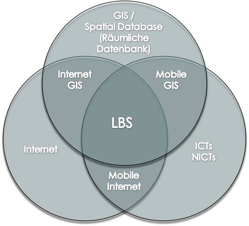
LBSs are formed by some domains and technologies (see figure 1) such as Geographical
Information Systems (GIS) and spatial databases, Information Communication Techno-
logies (ICTs & New ICTs) like mobile telecommunication systems, mobile devices like
Smartphones or PocketPCs, systems to determine the position as well as the global network
“Internet”.
Fig. 1:
Fields & Technologies that form a
LBS (Source: BRIMICOMB 2002)VestiGO! – More than an Adaptable Location-Based Mobile Game 71
Technologies to determine the position of a mobile device, a user and a group of users
respectively represent the basis of a general LBS communication model (positioning layer).
Such technologies are the Global Positioning System (GPS), the cellular technology,
Wireless Local Area Network (WLAN) or Bluetooth. Detailed explanations to these
technologies can be found in BULLERDIEK (2006) and SORNIG (2008). This paper focuses
on the GPS technology to determine the position of mobile devices. The development of a
spaceborne positioning system started in the early 1970s and was directed by the U. S.
Department of Defence (DOD) (HOFMANN et al. 2001). This system consists of the
following segments (HOFMANN et al. 2001, 12):
The space segment incorporates a set of satellites that broadcast signals and have
nearly circular orbits with an altitude of about 20,200 km above the earth.
The control segment manages and operates the positions of the satellites respectively.
The user segment includes different kind of receivers (GPS-Mouse or internal GPS-
Antenna for Smartphones or PocketPCs).
The accuracy of determining the position (x, y and z) depends on the number of satellites
(at least four are required) and their position to each other, surface of the earth and
obstacles such as high buildings in urban areas, weather conditions as well as on the GPS
receiver. More details on GPS in general and the accuracy of determining the position can
be found in HOFMANN et al. (2001).
As mentioned before, the positioning layer represents the basis of a general LBS
communication model. Furthermore, a LBS communication model consists of an
application layer that refers to the client application (e.g. Smartphone) and a middleware
layer that can be necessary if complex algorithms or operations have to be accomplished
too. The GIS component in a general LBS communication model translates the raw
network information, which comes from the positioning layer, into geographical coordinate
values (longitude and latitude) and processes computations or spatial analysis that can be
transmitted either to the middleware layer or directly to the application layer (SCHILLER et
al. 2004).
2.2 Mobile Location Based Games
Mobile LBGs refer to conventional video-games or traditional games like treasure-hunting
(Geocaching), paper chasing or playing cops and robbers that incorporates the current real
world position of the users. Games that are just delivered on mobile platforms (PSP,
handhelds or Gameboys) are mobile games and not mobile LBGs (PAELKE et al. 2008,
310).
LBGs include the same segments, respectively layers like a general LBS communication
model. Additionally, the components User Interface (UI), which represents and shows the
context of a game, and content, which refers to the game play, are integral part of a LBG
model (PAELKE et al. 2008). For both LBGs and LBSs the graphical representation (e.g.
digital maps) is a central element that covers the presentation of the location, the spatial
game content, map-based authoring, the GIS-based game content and the map-based
position and self location techniques (PAELKE et al. 2008). PAELKE et al. (2008) found out
the key subjects for the implementation of a mobile LBG as follows:72 C. Erlacher, K. H. Anders and S. Gröchenig
The user interaction illustrates the content presentation and interaction that combine
traditional maps (e.g. raster- or vector images) with augmented reality game styles.
The content authoring and acquisition covers all actives in respect to the design time,
which incorporates acquisition of real-world environments, the integration of virtual
media and content elements and existing GIS mapping tools.
The content representation and management refers to the run time handling of mobile
LBGs like spatial queries.
The positioning and communication segment incorporates position technologies
(BULLERDIEK 2006, SORNIG 2008, PAELKE et al. 2008) to determine the position of a
player. These positions, which can be sights, restaurants, cinemas, the current position
of a player or any place of interest, can be seen as Points of Interest (POI). A detail
explanation of such POIs can be found in SCHILLER et al. (2004).
2.3 Examples of LBGs
A huge bandwidth of developed mobile location based- and pervasive games are available
for different mobile platforms (MS Windows Mobile, Android, J2ME or Mac OS mobile).
Some of them are commercial games and some of them are completely free available
without any payment. Furthermore, such mobile location based games differ in complexity
such as multi- or single player mode, integrated client-server communication or
offline/online versions.
A famous example of a mobile LBG is “Can You See Me Now?” that represents a hide and
seek application. Players of this game are chased through a virtual model of a city by
‘runners’ (TANDAVANITJ et al. 2006) equipped with GPS- and WiFi technologies. Another
example is “Human Pacman” that refers to the content of the arcade game “Pacman”
published in the 1980s that incorporates mobile computing, WLAN, ubiquitous computing
and motion tracking technologies (CHEOK et al. 2004). The characters of the traditional
game (pacmen and ghosts) are represented by human players in the real world. This game
was played on several locations including the Central Park of New York City. A list of
games including instructions and descriptions can be found in BULLERDIEK (2006) and
PAELKE et al. (2008).
2.4 Designing and Developing a Mobile Location Based Game
Game development for game pads, personal computers, mobile games or mobile location
based games refer to similar steps. For a typical game design process these steps
incorporate the development of the core idea, writing of a game concept, producing the
artwork, programming the game engine, production of the game content, testing the game,
balancing and bug fixing (MASUCH et al. 2005). Furthermore, criteria such as players and
their roles, objectives, procedures, rules and underlying game mechanics conflicts,
obstacles and opponents and an outcome are critical parts for the development of a game
(MASUCH et al. 2005, 70). Another aspect refers to game developers that can be either
professionals or educated persons such as students. Students, for instance, do not have such
experiences and resources as professionals, but they are highly motivated.VestiGO! – More than an Adaptable Location-Based Mobile Game 73 Game development for location based mobile games implies the position of a client device (e.g. Smartphones or PocketPCs) in contrast to mobile games. Mobile LBGs utilize the player’s context that can be derived from a GPS sensor (PAELKE et al. 2008). The fundamental aspects of a mobile LBG are the size and duration of the game, the infra- structure available in the game location and the role that place has within the game play (REID 2008). Additionally, mobile LBGs incorporate further components, e.g. positioning (see chapter 2.1), connectivity (e.g. GPRS, UMTS), UI, spatial interaction, distributed infrastructure and custom game-engines (PAELKE et al. 2008). The UI design for mobile- and for desktop applications differs primarily in respect to the size, limited resolution and range of available colours of the graphical display for cellular phones, Smartphones or PocketPCs. The resolution for mobile handhelds ranges from 100*80 pixels for mobile phones and 480*800 pixels for Smartphones (e.g. HTC HD2). The information of the position that can be derived for example from a GPS sensor represents the input for spatial interaction. The proximity, the direction or the path to POIs can be seen as spatial interaction (PAELKE et al. 2008). Spatial interaction tools like a proximity sensor are very helpful in respect to spatial- and location awareness respectively. Last but not least the possibility of single- and multi player games influences the development, because of the implementation of web services to allow the communication between components (PAELKE et al. 2008). 3 From the first Vision to the mobile LBG “VestiGO!” 3.1 The Original Idea The original idea of this game named “Goldrush” referred to a virtual paper chasing mobile LBG for pupils, in order to combine fun with education. The idea of the game was elaborated by pupils, teachers and scientists of the Carinthia University of Applied Sciences, Department of Geoinformation. This game was designed as treasure hunt to solve puzzles and tasks. The puzzles represented hidden references to POIs and the tasks incorporated historical questions or questions to a specific topic (e.g. natural trails). Equipped with mobile phones several groups of pupils (two to four players per group) tried to find all given POIs, in order to obtain many credits. For each group a set of navigation tools was provided (e.g. a digital map – see figure 3 left and a digital compass – see figure 4 centre) to identify the POIs in less time, but the usage of these support helps decreased the credits for founded POIs. At the end of the game, which was represented through the last POI, the pupils retrieved the treasure. 3.2 The Current Version The goal of entertainment and pleasure is an important factor for a successful game or mobile LBG (PAELKE et al. 2008). Therefore, an iterative refinement of the game content, the visual representation of the content (e.g. digital map), and the game location as well as mobile environment are necessary to meet the player’s needs. The development of the mobile LBG “VestiGO!”, which is the new game name, incorporates a user-centred design process and prototype implementation to collaborate between developers, designers and end users (players) (BULLERDIEK 2006, PAELKE et al. 2008). The first series of prototypes were designed for the city of Villach and for the Villach Technology Park in Carinthia. However,
74                         C. Erlacher, K. H. Anders and S. Gröchenig

there were interested users who wanted to play the game “VestiGO!” in other regions than
mentioned above. Therefore, the concept model of the mobile LBG was redesigned to play
“VestiGO!” almost everywhere. Furthermore, the new concept model incorporates
authoring tools that facilitates the generation of new game versions of the mobile LBG
“VestiGO!”. PAELKE et al. (2008) highlights some authoring tools for mobile LBG and
describes the “Caerus” tool that allows users to add further digital maps and POIs. A
similar approach was used for the “VestiGO!” game creation. In order to enable a free
available authoring tool for the general public, a web GIS application (Editor) was first
integrated into the new conceptual model and later implemented. This procedure requires
an interface between the web GIS- and client application. Such interfaces are commonly
realized with the XML standard for configuration reasons or for a service oriented
architecture to exchange information between the middleware and the mobile client via web
services (SANCHEZ-NIELSEN et al. 2006). The interface definition between the mobile client
and the web GIS application incorporates the folder structure including the digital map and
the pictures of the POIs as well as the XML configuration, which stores the content of the
game play. The implementation of these measurements will allow players of the mobile
LGB to generate their own games for almost each location.

3.3 The Program Flow
The client application of the mobile LBG “VestiGO!” is modularly designed, which implies
the advantage of fast source code adaptation and adding further components to the system.
Figure 2 displays the program flow of the game that illustrates the conceptual model too.
This concept framework is independent in respect to the any mobile platform (e.g.
Windows Mobile, Android or Mac OS X). Each process in the flow diagram (see figure 2)
represents a module that consists of several sub-modules and sub-processes. First, the client
application verifies the accurateness of the folder structures including the files and the
content of the game, which is documented within the XML configuration. Afterwards, the
content of the game is interpreted, prepared and stored in the Random Access Memory
(RAM) for a fast interaction when playing the game and in a database for regarding the
system stability. The next process incorporates the GPS device detection and connection, in
order to receive the satellite information. The processes “Position Locator Activator” and
“Tracker Activator” try to start the threads for determining the current position (Latitude
and Longitude of the WGS84 – World Geodetic System – coordinate system) of the client
and track recording. After starting the threads the user could start the POI search. For the
first POI the user gets a message (e.g. in form of a spoonerism) that incorporates the task
for the first POI search. Then, they have the possibility to use supportive tools such as a
digital map, which shows the current position of the player and the destination (POI). The
usage of the supportive gadgets is possible through the entire game, but decreases the
credits for founded POIs. The POI search uses trigger elements that describe a spatial event
such as geofencing, which can be a circular geofence including centre coordinates, a
radius and the actual trigger like entering, leaving or residing inside that geofence for a
certain amount of time (MARTINS et al. 2009, Article No.: 38 p. 3). In this case the trigger is
activated once the user enters the buffer zone (circle) around the POI and a question
appears on the mobile screen. The player has to answer the question, in order to retrieve the
next task. At the end, when all POIs are found, the module “Game Statistic Viewer” is
presented to the player, which incorporates the time for each POI, the correct answers and
the total amount of credits.
VestiGO! – More than an Adaptable Location-Based Mobile Game                 75

Fig. 2:    The program flow of the mobile LBG “VestiGO!”

4     Feedback and Upcoming Versions
The game will be developed for different mobile platforms through the development of a
series of prototypes (e.g. Windows Mobile, Android or iPhone OS). The first two pro-
totypes for the city of Villach and the Villach Technology Park are already implemented,
tested and evaluated. GPS connection, user interaction during the game, user comments and
suggestions for improvements were documented. Problems concerning the GPS connection
during the game could occur along narrow streets and high buildings. Therefore, users have
the possibility to define the destination radius to the POIs for each game in order to deal
with the GPS imprecision. Pupils, students and professors of the University of Applied
Sciences were involved to evaluate and test “VestiGO!”. The outcome of this evaluation
was very positive as pupils, students and professors were highly enthusiastic by the game.
Especially games with a historical- and cultural content (e. g. historic city centre of Villach,
76                        C. Erlacher, K. H. Anders and S. Gröchenig

Fig. 3:   The left image displays a support module of the mobile LBG “VestiGO!” that
          represents a digital map of the game location. The right image shows the web
          based game editor.

see figure 4 right) as well as natural trails raised enormous interest. These prototypes were
developed for the MS Windows Mobile 5 platform and tested with the HTC PocketPC
“P3300 Premium” (see figure 3 left that represents a digital map).
The second series of prototypes incorporates a mobile LBG “VestiGO!” version, which can
be used for almost each location. Furthermore, this series provides an authoring tool,
packed within a web GIS application that allows players to generate their own game con-
text for any area (see figure 3 right). The new prototypes are ported at least on the mobile
platforms “Windows Mobile 6.5” (e.g. Smartphone HTC HD2) and “Android 2.0” (e.g.
Smartphone HTC Hero). The aim is to provide the first prototype for the Windows mobile
platform by the end of March 2009 and the first prototype for the Android platform by the
end of June 2009. Another valuable output of this project is the component framework (see
figure 2) that consists of modules for verification-, configuration- and interpretation tools,
GPS detection and connection, position determination, tracking and POI search. These
modules are reusable and extendable, which can be used for other LBSs and LBGs.

5     Conclusion and Outlook

This paper shows the development of the mobile LBG “VestiGO!” that can be played in
almost each location and provides an authoring tool for creating user specific game content.
Furthermore, component framework of this game is portable for any mobile platform and
provides useful extendable modules for other LBGs as well as LBSs in the fields of tourism
or sport events. The project “Applications one the Move” is a two year funded project.
Now, after one year we can state that we are within our proposed time schedule. The basic
modules of our framework described in chapter 3 are implemented for the Windows Mobile
platform and used in our application VestiGO!. Currently we are adopting the modules to
the Android platform. But still we have some modules on our roadmap to be finished by the
end of this year (at least for one mobile platform). These missing modules are described
briefly in the following paragraphs.
VestiGO! – More than an Adaptable Location-Based Mobile Game 77
Fig. 4: The left image represents a mountain chain in Carinthia and virtual objects
representing the peaks of the mountains “Goldeck” (large virtual object that is
closer) and “Oisternig” (small virtual object that is far away) through a digital
camera. The image placed in the centre displays the compass help functionality
and the right image shows a historical map of Villach that is used as help too.
It is scheduled that the third series of building prototypes will start at the end of this year.
This series will provide an offline and online version of the mobile LBG “VestiGO!” as
single- and multi player mode. In the online version it should be possible to trace the POI
search with the help of a web GIS application, which can be useful for sport events.
Furthermore, an online version of this game provides the possibility to use different digital
map representations (e.g. Google Maps or MS Bing Maps) via a browser. For a multi-user
mode a refinement of the conceptual design has to be done. PAELKE et al. (2008) illustrates
example architecture of a custom mobile LBG, which uses standard components and
incorporates a client server architecture that communicates over the HyperText Transfer
Protocol (HTTP). Additionally, a further support tool can be integrated within the
component framework that could view a virtual path from the current position of a player to
a specific POI through the digital camera of a Smartphone. Figure 4 displays a mobile
Android application that adds virtual objects representing the peaks of two mountains to the
digital camera perspective.
Furthermore, the integration of an advanced information module for POIs can be
implemented as hypertext, speech output, images or movies. Another additional help
module can be a spatial decision support tool that computes the nearest POI, the shortest
path to the POI or the best POI in order to the distances and credits. SORNIG (2008)
describes a mobile spatial decision support tool, which indicates the best order of POIs in
respect to the criteria such as culture, events, parks or weather conditions. All modules
mentioned before can be integrated into the current component framework of the mobile
LBG “VestiGO!” and are reusable for other mobile LBGs or LBSs.
Acknowledgment – Many thanks to the Austrian Federal Ministry of Science and Research
for the financial support through the Sparkling Science research program.78 C. Erlacher, K. H. Anders and S. Gröchenig References BENFORD, S. A., CRABTREE, M., FLINTHAM, A., DROZD, R., ANASTASI, M., PAXTON, N., TANDAVANITJ, M., ADAMS, M. & ROW-FARR, J. (2006), Can you see me now? ACM Transactions on Computer-Human Interaction, 13 (1), pp. 100-133. BRIMICOMBE, A. J. (2002), GIS – Where are the frontiers now? GIS 2002, Bahrain, pp. 33- 45. BULLERDIEK, S. (2006), Design und Evaluation von Pervasive Games. Unpublished Diploma Thesis, Institut für Multimediale und Interaktive Systeme, Universität zu Lübeck, Lübeck. CHEOK, A. C., GOH, K. H., LIU, W., FARBIZ, F., FONG, S. W., TEO, S. L., LI, Y. & YANG, X. (2004), Human Pacman: a mobile, wide-area entertainment system based on physical, social, and ubiquitous computing. Personal and Ubiquitous Computing, 8 (2), pp. 71-81. HOFMANN-WELLENDORF, B., LICHTENEGGER, H. & COLLINS J. (2001), GPS Theory and Practice. Fitfth edition. Springer-Verlag, Vienna. MARTENS, J. & BARETH, U. (2009), A declarative approach to a user-centric markup language for location-based services. International Conference On Mobile Technology, Applications, And Systems, Proceedings of the 6th International Conference on Mobile Technology, Application & Systems, Nice, France. MASUCH, M. & RUEGER, M. (2005), Challenges in collaborative game design developing learning environments for creating games. In: Third International Conference on Creating, Connecting and Collaborating through Computing, IEEE Computer Society Washington, DC, USA, 67- 74 OPPERMAN, R. (1994), Adaptively supported adaptability. International Journal of Human Computer Studies, 40 (3), pp. 455-472. PAELKE, V., OPPERMANN, L. & REIMANN, C. (2008), in MENG, L., ZIPF, A. & WINTER, S. (Eds.), Map-based Mobile Services Design, Interaction and Usability. Springer-Verlag, Berlin / Heidelberg, pp. 310-333. PREM, R. (2009), Identifikation optimaler Standorte für Sonnentor-Franchisepartner in der Region Wien mit Hilfe des Analytischen Hierarchieprozesses (AHP). Unpublished Diploma Thesis, Institut für Marketing und Innovation, University of Natural Resources and Applied Life Sciences, Vienna. REID, J. (2008), Design for coincidence: incorporating real-world artefacts in location- based games, in: Proceedings of ACM International Conference on Digital Interactive Media in Entertainment and Arts. DIMEA 2008, Athens, Greece. SANCHEZ-NIELSEN, E., MARTIN-RUIZ, S. & RODRIGUEZ-PEDRIANES, J. (2006), An Open and Dynamical Service Oriented Architecture for Supporting Mobile Services. International Conference On Web Engineering, Proceedings of the 6th International Conference on Web Engineering, Palo Alto, California, USA, 263, pp. 121-128. SCHILLER, J. & VOISARD, A. (2004), Location-Based Services. Elsevier, San Francisco. SORNIG, J. (2008), Development of a distributed Service Framework for Location-based Decision Support. Unpublished Diploma Thesis, School of Geoinformation, Carinthia University of Applied Sciences, Villach.
You can also read