WAIWERA
CATCHMENT
 Information sheet
         May 2014

  www.orc.govt.nz
←
→
Page content transcription
If your browser does not render page correctly, please read the page content below
WAIWERA
CATCHMENT
Information sheet
May 2014
www.orc.govt.nz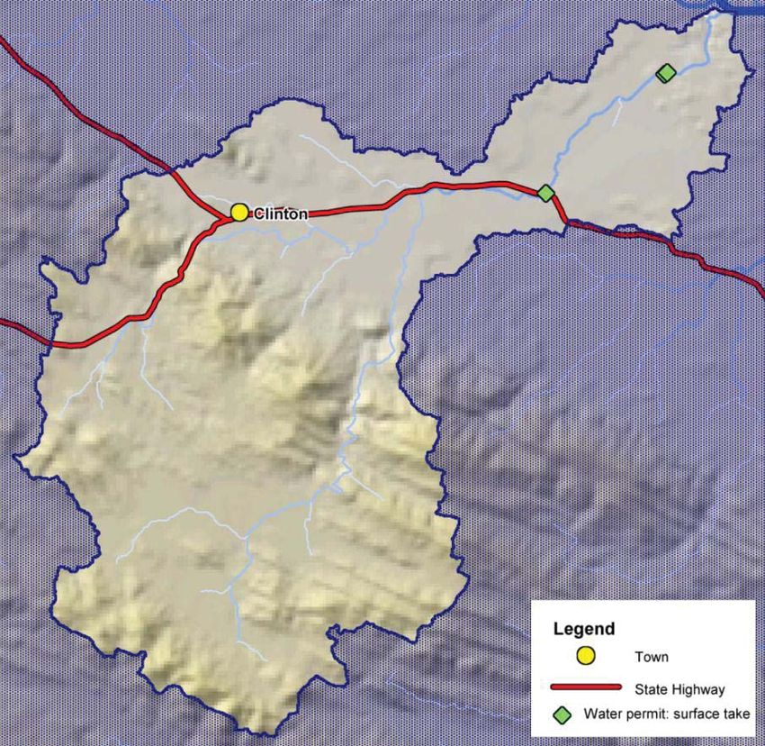
CONTENTS

Location                                          2

Natural values                                    2

Commercial, social and cultural values            6

Water takes within the catchment                  7

References                                        9

LOCATION
Located in South Otago, the Waiwera
catchment is a tributary of the Clutha
River/Mata-Au. Their confluence is
approximately 20 km upstream of
Balclutha, near where the Pomahaka
joins the Clutha/Mata-Au near Clydevale.
Figure 1 shows the catchment, which
has an area of 209 km2. The headwaters
are located in the Wisp Range from
which it flows north then north east. The
two principal tributaries of the Waiwera
catchment are the Kuriwao and Awakia
Streams.

It is thought that Waiwera is named after
Waiwhero, a Waitaha chief.

                                                 Figure 1. Map of the Waiwera catchment.

NATURAL VALUES

Topography, geology and soils
The Waiwera River rises in the steep valleys and swampy flats of the Southland syncline area,
before making its way through rolling hill country and low-lying areas around Clinton.

Soils within the Waiwera catchment, particularly on the river flats and terraces, are considered
fertile. Pallic soils dominate the catchment.

Waiwera Catchment Information Sheet – May 2014                                               2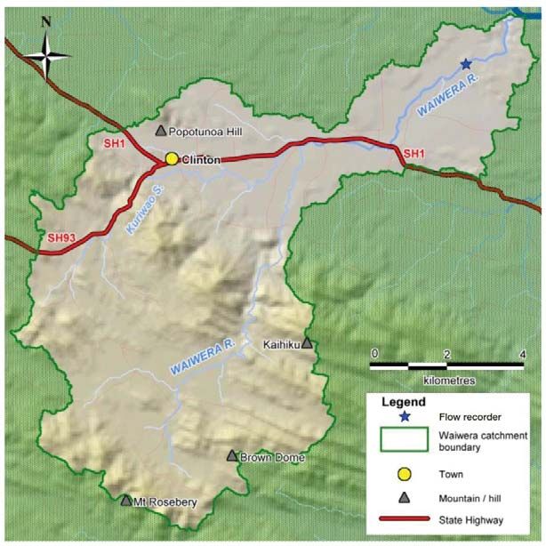
Rainfall
The Waiwera catchment’s climate is considered mild, with consistent rainfall throughout the
year. Annual catchment rainfall varies from around 700 mm in the low lying parts of the
catchment through to nearly 1,400 mm in the upper catchment. Rainfall intensities vary greatly
throughout the catchment due to a combination of factors including altitude, aspect and
topography.

Hydrology and river flow data
Several years of data from various sites within the Waiwera catchment have been analysed to
extract information about stream flows within the catchment. The location of the continuously
monitored flow recorder is shown in Figure 1, at about 1.4 km upstream of the confluence with
the Clutha /Mata-Au.

Before April 2010, all flow data collected were from one-off gaugings. Since 2010 the
continuous recorder has provided data, and it is the proposed minimum flow site.

Table 1 outlines the Waiwera hydrological statistics. The mean annual low flow (MALF) 1 is 310
l/s at the proposed flow monitoring site.

                                                  Catchment              Lowest flow              MALF (l/s)
Site
                                                  area (km2)            recorded (l/s)

Proposed minimum flow site                             207                     183                    310

Table 1. Hydrological statistics of the Waiwera catchment.

Significant wetlands
The Water Plan’s Schedule 9: Regionally Significant Wetlands lists three wetlands, which are
wholly or partly in the Waiwera catchment:
x         Three Stones Fen Complex
x         Hazeldale Fens
x         Kuriwao Saddle Fen.

These significant wetlands, and many others which are not identified within the Water Plan, are
an important part of the hydrological functioning within the catchment, modifying downstream

1
 MALF is the average of the lowest flows observed for any seven-day period, for each year recorded. If records of
flows are not available or are less than adequate, MALF can be estimated by other methods which take account of
precipitation and catchment area. It is used in Otago’s Water Plan for setting allocation limits.

Waiwera Catchment Information Sheet – May 2014                                                               3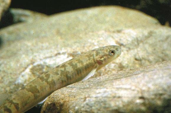
flood peaks and low flows. Wetlands act to filter water passing through them while providing
habitat for a range of bird and aquatic life.

Catchment ecology

Flora
The upper catchment is dominated by red tussock, with small pockets of podocarp forest. There
is some production forestry in the upper catchment. The remainder of the catchment is highly
developed with pasture grasses.
Birds

The Waiwera catchment and surrounding environment is a significant breeding ground and
juvenile rearing habitat for mallard, shoveler, paradise shelduck and pukeko. The area is also a
moulting site for mallard.

Fish
The Waiwera River is a brown trout fishery popular with anglers. Native fish species found in the
catchment include both long- and shortfin eel, common bully, upland bully and galaxiids. One
species of freshwater crayfish is also present in the catchment.

At least one galaxiid species is present in the catchment (Figure 2) shows a typical Otago
galaxiid). The status of any galaxiid in the Waiwera catchment will be Nationally Endangered,
due to threat of extinction. The longfin eel is also of conservation significance as its population is
listed as being in gradual decline.

Figure 2: Galaxiid (Roundhead)

Waiwera Catchment Information Sheet – May 2014                                                    4

Schedule 1A natural values
Schedule 1A of the Water Plan identifies the Waiwera River and tributaries as having
high natural value. The values identified in Schedule 1A are:

                     Ecosystem values
Waiwera River
                     Provides access unimpeded by structures such as weirs and
                     culverts; free of aquatic pest plants; significant habitat for trout
                     and salmon spawning and juveniles; riparian vegetation of
                     significance to aquatic habitat; significant presence of trout, eel,
                     and the threatened galaxiid species; a significant range of
                     indigenous invertebrates.

                     Ecosystem values
Kuriwao Stream
                     Provides access unimpeded by artificial means such as weirs and
                     culverts; significant habitat for trout spawning and juveniles;
                     significant presence of trout and eel.

Waiwera Catchment Information Sheet – May 2014                                              5
COMMERCIAL, SOCIAL AND CULTURAL VALUES

Land use
The upper Waiwera catchment is primarily used for extensive sheep and beef grazing. The mid
and lower reaches of the catchment are dominated by pastoral farming with smaller farms
having higher stocking rates relative to the upper catchment. In recent years, dairy farming has
become increasingly common in the lower catchment. There is some production forestry in the
upper catchment.

Commercial value
Agriculture is the main economic activity within the catchment. Clinton is a rural service town in
the catchment. Clinton is also an excellent base for tourists interested in trout fishing. There is
commercial eeling in the lower reaches.

Recreational values
The most significant recreational uses within the Waiwera catchment are angling and game bird
hunting. Eeling, BBQs and picnicking are also popular. South Otago is well-used by waterfowl
hunters, and the Waiwera catchment is a very popular waterfowl-hunting destination.
The National Angler Survey estimated 1202 angler days were spent on the Waiwera River in the
2007/08 season (NIWA, 2009). The Waiwera offers classic small stream fishing. The river is
accessed from several road bridges or across farmland. Most of the angling takes place in the
middle reaches. More adventurous anglers frequent the upper reaches, while the lower reaches
are difficult to fish due to crack willow infestation and a lack of public access.

Iwi values
Water plays a significant role in the spiritual beliefs, values and cultural traditions of iwi, and the
health of water bodies and the condition of water are of particular consideration.
The Waiwera River is listed in Schedule 1D in the Water Plan as having significance to Kai
Tahu as a source of mahika kai – a place where food is procured or produced. Examples of
waterborne mahika kai include eel, whitebait, kokopu (galaxiid species), koura (freshwater
crayfish), freshwater mussels, indigenous waterfowl, watercress and raupo.

2
    There is a wide margin of error in the estimate: (plus or minus 80)

Waiwera Catchment Information Sheet – May 2014                                                      6
Historic values In the late 1800s the Otago Acclimatisation Society had one of the largest fish hatcheries (salmon and trout) in New Zealand, located on the Waiwera River. The Waiwera Flour Mill (Figure 3) was established in 1872 by two brothers, Joseph and John Wright on the edge of the Kuriwao Stream, which was used to turn the wheels running the mill machinery. The mill was eventually closed down in 1935 (Source: South Otago Museum). The local school used the river for Figure 3. Flour Mill at Waiwera. Photo taken after swimming and historic Maori ovens are 1885 (Photo courtesy of South Otago Museum). found close by. WATER TAKES WITHIN THE CATCHMENT Permitted surface water takes Under the Resource Management Act (RMA) and the Water Plan, water can be taken from the Waiwera River and its tributaries for an individual’s reasonable household and animal drinking- water needs, and for fire-fighting purposes. The Water Plan permits small water takes subject to meeting specified conditions. Accordingly, the ORC does not hold information on water taken under permitted activity rules. Consented surface water takes In the Waiwera catchment there are currently two surface water permits able to take 126 l/s. These are primary allocation. Two other consents exist, one for groundwater not connected to the river, and the other is to take surplus surface water already taken under a consent, as a “retake”. As at April 2014, there is an application to take 23 l/s as primary allocation. Current take consents account for 81% of the primary allocation available for the Waiwera catchment, as specified under Policy 6.4.2 of the Water Plan. The primary allocation limit for the Waiwera River is currently 155 l/s, being the default 50% of 310 l/s (MALF). There is thus some primary allocation still available. Table 2 outlines the consented water takes in the catchment. Figure 4 shows the location of the current surface water takes. Waiwera Catchment Information Sheet – May 2014 7
Number            Combined                    Purpose          Water source
Water take
                      of         instantaneous take
                   consents            rate (l/s)

                        2                  126                Irrigation, stock    Waiwera River
Primary
                                                              water, and dairy     surface water
surface water
                                                                shed supply
permit
                        1                   -                      Retake         Captured excess
Retake
                                                                                       runoff

Table 2. Consented takes within the Waiwera catchment (as of April 2014)

Figure 4. Location of surface water takes within the Waiwera catchment.

Waiwera Catchment Information Sheet – May 2014                                                     8
FOR FURTHER INFORMATION
Otago Regional Council (2004) Regional Plan: Water.
Otago Regional Council (2006) Management Flows for Aquatic Ecosystems in Waiwera
River.
Otago Regional Council (2007) The Water Resources of the Pomahaka and Waiwera
Rivers.
NIWA (2009) Angler usage of lake and river fisheries managed by Fish
& Game New Zealand: results from the 2007/08 National
Angling Survey.
Department of Conservation (2004) New Zealand non-migratory galaxiid fishes recovery plan
2003-13. Threatened Species Recovery Plan 53.
Wellington.
South Otago Museum
Waiwera Catchment Information Sheet – May 2014 9You can also read