Walking the Saxon Shore Way through Medway - Medway Council
←
→
Page content transcription
If your browser does not render page correctly, please read the page content below
Walking the Saxon Shore Way through Medway
Contents                                    Key to maps

                                              Gradient down

WALK                               PAGE       Gradient up

                                              Tourist information centre
1 Cliffe to Cooling . . . . . . . . . . 5
                                              Car parking

2 Cooling to High Halstow . . . . 9           Viewpoint

                                              Toilet
3 High Halstow to Hoo . . . . . 13
                                              Refreshments

4 Hoo to Upnor . . . . . . . . . . . 17       Railway station

                                              Point of interest (open to the public)
5 Upnor to Strood . . . . . . . . . 21
                                              Point of interest

6 Rochester to Gillingham . . . 25            Pub

                                              Caution
7 Gillingham to Upchurch . . . 31
                                              Disabled route
The complete walk

This map shows the route of the
Saxon Shore Way through Medway.
The black dots indicate the starting
points for each of the seven walks
                                                                            Medway
contained in this booklet.                            Cliffe
                                       To Gravesend
                                                      Salt Lane                             High Halstow
                                                                     Cooling
                                                                                            Fenn Corner
For those wishing to use Ordnance
Survey maps, the following cover the
Medway area: Landranger Map 178
and Explorer Maps 148 and 163.
                                                                            Hoo Marina

                                                                    Upnor

                                                                               Gillingham
                                                        Rochester

                                                                                              Otterham
                                                                                              Quay Lane    To Sittingbourne
Walking the
Saxon Shore Way
through Medway
The Countryside Access Charter

    Your rights of way are:                                       And, wherever you go, please follow the Countryside Code:
    ●   Public footpaths – on foot only. These are waymarked      ●   Be safe – plan ahead and follow any signs.
        in yellow.                                                ●   Leave gates and property as you find them.
    ●   Bridleways – on foot, horseback and pedal cycle.          ●   Protect plants and animals, and take your litter home.
        These are waymarked in blue.                              ●   Keep dogs under close control.
    ●   Byways – all traffic. These are waymarked in red.         ●   Consider other people.
    ●   Restricted byways – unless stated, on foot, horseback,
        pedal cycle and non-mechanically propelled vehicles.

    On rights of way you can:
    ●   Take a pram, pushchair or wheelchair if practical.
    ●   Take a dog (on a lead or under close control).
    ●   Take a short diversion around an illegal obstruction or
        remove it sufficiently to get past.

    For your information:
    Medway Council has a duty to protect, maintain and record
    rights of way and any problems encountered on them should
    be reported to: Medway Council, Public Rights of Way Team,
    Frontline Services, Regeneration, Community and Culture,
    Annex B, Civic Centre, Strood, Kent ME2 4AU
    Phone: 01634 333333
    Email: customer.services@medway.gov.uk

2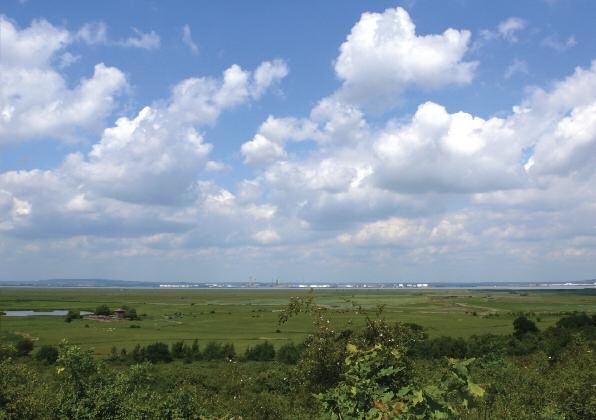
Introduction

      he long distance path, known as The Saxon Shore Way,            South-east Britain had traded with Europe since at least the late
T     stretches from Gravesend to Hastings, some 160 miles            Bronze Age, so it would have been only natural for this to have
from start to finish. Originally opened in 1980, it has since         continued throughout the Roman period.
been in parts re-routed and extended. Where possible it uses
existing Public Rights of Way and allows the walker to follow         The 26 miles of the route passing through Medway have been
roughly the coastline as it was around 1,500 years ago. The           divided into seven sections. Six of the sections are five miles
way takes its name from the line of fortifications bu ilt along the   or less in length. Each section offers the walker something
southern and eastern coasts by the Romans in the third century        different - from the atmospheric marshland between Cliffe
AD. Originally believed to have been built to protect Britain         and High Halstow, the busy streets of Rochester and Chatham
from marauding tribes such as the Saxons, new research has            to the stunning estuary views along the riverside path from
concluded that they were more than likely fortified ports.            lower Gillingham ■

                                                                                                                                          3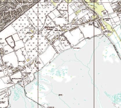
WALK           1
Cliffe to Cooling
 DISTANCE: 6.3 miles (10.1km) • LEVEL OF DIFFICULTY: Easy • MINIMUM TIME: 2.5 hours (approx)

    or the purpose of this guide, the Saxon Shore Way starts at         tide offer a vast bird table for the hundreds of thousands of
F   the local authority boundary of Gravesham and Medway.               wetland birds that use the Greater Thames Estuary. This
Access to here is from the nearby RSPB car park in Salt Lane*           section of shoreline also provides an opportunity to see the
(see map). Follow the road back to the first junction on your           important industrial activity which has changed the landscape.
right (left from Cliffe village,) continuing along the public           The clay quarries to your right were dug to support the
footpath to the mineral railway crossing, before turning right          cement industry, resulting in flooded lagoons into which
again. From here the path passes between the gravel works               dredged mud from the River Thames is disposed. These
and onwards to the river’s edge. The mudflats exposed at low            lagoons provide a valuable habitat for plants, insects and birds.

                                                                                                     Salt Lane

                                                                                                                     * Parking available here or
                                                                                                                       in Cliffe village see map
                                                                                                                       on page 7.

                                                                                                                                                   5
                                                                                                                                                   7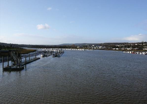
1   WALK            Cliffe to Cooling

    Continuing onwards, you pass the wreck of the Hans Egede
    (1) and arrive at Cliffe Fort (2), built in 1860. The fort is one of
    three built to defend the Thames. To your left are the remains
    of the Brennan torpedo rails used to launch the world’s first
    guided missile. Continue past the fort and then underneath
    the conveyor that is used to transport imported sand and               50,000 small snails and is thought to be more productive than
    gravel from the ships to the nearby works in Salt Lane.                a tropical rainforest.

    The path now turns inland following the line of the Cliffe             To your left are Cliffe Pits and Pools (3), long neglected but
    Creek. It is always worth peering over the sea wall to see the         now owned and managed by the RSPB as a nature reserve.
    bird life. At low tide, birds such as redshank, dunlin and             Salty by nature, the lagoons support large numbers of
    ringed plover can been seen feeding on the exposed mud,                important breeding and wintering birds. The track below the
    an extremely rich source of food for wetland birds, containing         chalk cliff and to the right of you is Salt Lane – no doubt a
    numerous insects. Each square metre of mud supports over               reference to the historic manufacturing of salt in the area.

6
Cliffe to Cooling                       WALK        1

Continue along Pickle’s Way, which offers far reaching views        Heading on towards Cooling the path takes walkers from
across the North Kent Marshes. Here the ditches, which are          arable land and on to grazed grassland. Shortly before
so characteristic of the marshland landscape, can be seen.          Cooling Castle is a good example of a wet pasture – a grassy,
As well as providing an important habitat for plants,               wet field that is grazed by cattle or sheep. The ditches here are
dragonflies and water voles, the ditches act as wet fences.         lined with tall crack willows, which as their name suggests,
                                                                    tend to collapse upon maturity. The collapsing is a means of
After passing through Cliffe with its impressive church of          spreading and any part of the
St Helen’s (4) built around 1260, the Saxon Shore Way               willow touching the ground will
crosses slightly higher arable land. Here, red legged and the       create new roots and growth ■
less common grey partridge can be found along with hares.
The latter cross the open landscape at tremendous speed
(up to 70km per hour) and are considerably larger than
rabbits. Look for their taller, more erect ears and their running
rather than hopping movement.

                                                                                                                                        7
WALK 2
Cooling to High Halstow (Fenn Corner)
DISTANCE: 3.6 miles (5.7km) • LEVEL OF DIFFICULTY: Moderate • MINIMUM TIME: 1.5 hours (approx)
ooling Castle (5) is a manor house fortified by John de
C Cobham in 1380. At this time in history, marauding French
and Spanish soldiers were burning and pillaging coastal towns
and villages. Remnants of the moat can be seen to the west and
north of the castle. Its geographical context in 1380 would have
been very different from today – to the north would have been
extensive salt marsh and wetlands. The castle, which is sited on
the higher lands, reflects this historic shoreline.
Cooling Church (6) dates mainly from the 13th century and has
an interesting vestry covered in shells. Its churchyard is the
unassuming location of the 13 lozenged-shaped body stones
made famous by Charles Dickens in Great Expectations,
92 WALK Cooling to High Halstow (Fenn Corner)
although in the book there are only five. The graves are of It is easy to forget that, with its feeling of isolation, this area is
children who probably died of marsh fever or Ague, now so close to London and Medway. Northward Hill (8) is as the
known as malaria, as carried by the marsh mosquito. name suggests – on the northward side of High Halstow.
Here, old oaks provide suitable conditions for nesting and
Beyond Cooling the walk enters orchard country. The siting of roosting grey herons – the heronry is the largest in England.
the orchards maps drier lands and offers blossom in late April Roosting alongside the herons is the once rare, little egret.
and colourful fruit in September. The orchard trees are cathedral- These can be seen in increasing numbers throughout the year.
like with pillars supporting a canopy roof. Bromhey Farm (7), Less than 10 years ago walkers would have been lucky to have
owned by the RSPB, provides unsurpassed views across the see just one, but now up to 70 can be seen at any one time.
marshes and Northward Hill. Excavations in the 1920s and While in the wood, also listen out for the familiar drumming
1930s found evidence of Iron Age and Roman pottery kilns, sound of woodpeckers. Northward Hill is the largest and oldest
providing an insight into the marshes’ distant industry. RSPB nature reserve, established in 1955. It is only one of two
woodlands along the route through Medway, the other being at
The steep walk up the hill to the woods of Northwood Hill Upnor. From ther e you would have to walk all the way to
offers superb views across to Essex and central London. Hastings before you found another.
10Cooling to High Halstow (Fenn Corner) WALK 2
The path continues across arable fields to Clinchstreet Farm. At the footpath crossroads, turn right into Bessie’s Lane,
Here, for the first time on the walk, you can see across the a reference to Elizabeth I, sometimes referred to as Good
peninsula to the chimney of the Grain power station. This Queen Bess. This ancient green lane is traditionally believed
stands to the south of the village of Grain on the edge of the to be the route used on her journey from London to Chatham
Medway Estuary, whose water is used for cooling. The water Dockyard in 1573. Her boat would have moored off the coast
intake catches fish, providing a useful record of the type and at Egypt Bay, a remote spot,
number using the estuary. In the late 1960s, local people were popular with smugglers in
concerned about the effects of the smoke. A helicopter the 18th century ■
dangled a pair of tights above the chimney to assess damage.
No one remembers the result – but not hanging from
helicopters above chimneys is probably good advice.
11WALK 3
High Halstow to Hoo
DISTANCE: 4.2 miles (6.7km) / 3.3 miles (5.3km)* • LEVEL OF DIFFICULTY: Moderate • MINIMUM TIME: 2 hours (approx) / 1.5 hours*
ake care as the path crosses the main A228 at Fenn Street. verges and offer views across Medway from the Isle of Sheppey
T Fenn is a term used to describe a wet marshy woodland. to the Kent Downs. The landmarks around the Medway estuary
Pass down the side of the garage through a maze of back can se em to appear in different positions as you walk the path.
gardens and paddocks. At the last garden the path turns right
along the drive into Roper’s Green Lane. Fringed with trees and
shrubs, it provides dense shade on the hottest day and a
contrast to the familiar open aspect of the walk. Al ong the way
you may spot the speckle wood butterfly or hear the song of
dunnock and wren.
Nearing the train line the path opens at the railway known as
the mineral line, originally used to serve the sand and gravel
pits close to Grain. The large arable fields contain flower rich
* See higher route on page 14 133 WALK High Halstow to Hoo
Continue onwards past Roper’s Farm, Tile Barn Farm and then religious princess
down to Stoke Road, which must be crossed with care. The believed to have been
path follows quiet tracks past numerous farm houses, most of responsible for an
which no longer have links to the ownership or management unrecorded miracle in
of the surrounding land. They are a reminder of when farms the village in the
were small and worked by many local hands. Just before seventh century.
Abbots Court Road the path divides into two. This allows you The church (10), standing
to either follow the shoreline at low tide or continue over on the site of its Saxon
higher ground through Hoo and on towards Beacon Hill. predecessor dates mainly
from the 14th century,
Should you choose the higher route, you will find the village is though Roman tiles and
still relatively small and provides parking, refreshments and bricks have been reused throughout. There are five yew trees
toilets. Mentioned in the Domesday book its full name since in the churchyard, of which one is believed to be more than
1968 is Hoo St Werburgh. St Werburgh was a devoutly 1,000-years-old. The artist William Hogarth visited the church
Higher route
Lower route
14High Halstow to Hoo WALK 3
in 1793 during his walking tour of the peninsula and the Isle
of Sheppey. In the late 19th and early 20th centuries Hoo was
a hive of industrial activity. Using the surrounding agricultural
land for raw materials, bricks and pottery were produced and
gravel extracted. By the 1930s these industries were in decline,
with Hoo once again becoming a quiet backwater.
To continue along the lower route, head towards the sea wall
where the path turns eastwards. Along the mud banks the
derelict hulks of disused barges are slowly dismantled by time
and tide. Strangely romantic, they are a mixture between an
archaeological site, graveyard and wildlife habitat. Across the
water stands Hoo Island, owned by Medway Ports and used to
dispose of river dredgings. On its eastern edge stands Hoo Fort
(9) built in 1871, with its round and solid wall braced against
Low tide route only
the weather. Hoo Marina is a real hive of river-related activity
and there is always something of interest going on ■
15WALK 4
Hoo to Upnor
DISTANCE: 2.21 miles (3.5km) / 1.85 miles (2.9km)* • LEVEL OF DIFFICULTY: Easy / moderate* • MINIMUM TIME: 1 hour (approx) both routes
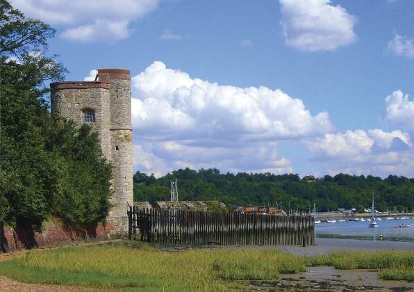
eyond Hoo Marina, the path soon becomes a narrow since washed away. As the beach opens out, Upnor Castle
B pebble beach tucked between the continuously can be seen in the distance and the walker will see a similar
encroaching river and its erosion scarred bank, heavy with viewpoint to that used by JMW Turner (1775-1851).
trees. Emerging from the woodland stand the mellow red
bricked remains of Cockham Wood fort (11). Built in 1669 by
Sir Bernard de Gomme as a direct result of the Dutch raid on
Chatham Dockyard in 1667. Never having seen action, it was
considered redunda nt by 1778 and all 48 of its guns were
removed, allowing it to fall into quiet disrepair. Scattered along
the beach are the remains of clay pipes, earthenware jars, old
glass bottles and the larger remains of dead trees. Among this,
a Second World War pillbox lies stranded, its foundations long
Low tide route only
* Lower route 174 WALK Hoo to Upnor
A frequent visitor to Medway, his painting of the castle, from. They were also the scene of festivities, during the lord
completed in about 1831 is now on display in The Whitworth mayor’s annual visit, at which it soon become customary to
Art Gallery in Manchester. Upon reaching Lower Upnor, the create a mayor and mayoress of Upnor.
path climbs up on to the river front and past the Arethusa
Venture Centre. It is named after a four-masted barque All along the length of Lower Upnor, the waters of the
originally moored here and now on display in a New York Medway lap against row upon row of sailing boats, a sign of
museum. Two obelisks, known as the London stones, can also the increased leisure use of the river. However, 150 years ago
be seen here. These are a reminder of the time when the City in their place would have been the infamous prison hulks
of London’s Fishermen were given the rights to fish on the used initially to hold French prisoners of war, many who were
northern side of the river, from here to Yantlet Creek, where buried on nearby St Mary’s Island. It was also from one of
the smaller of the stones, dated 1204, is thought to have come these that Magwitch made his escape in Charles Dickens’
18Hoo to Upnor WALK 4
novel Great Expectations. Although for the purposes of the fleet under the command of Admiral De Ruyter, sailed up
novel it was relocated in the Thames. From the village the the river and destroyed much of the anchored British fleet.
path continues along higher ground, shaded mainly by mature Capturing the 100-gun Royal Charles, which had originally
sycamore trees until it turns into the picturesque cobbled high been brought back from the Netherlands by Charles II, upon
street of Upper Upnor. Here, it is flanked by tall slim brick his restoration in 1660. The diarist Samuel Pepys (1633-1703),
and weatherboarded houses, leading back down towards the then employed by the naval board, writing in the days
water’s edge. Once a thriving riverside resort up until the following the raid, noted of the castle’s gunners that: “they
Admiralty closed its beach for the duration of the Second themselves shot until they had hardly a gun left”. From the
World War, it owes its existence to the castle (12). Built castle, the path follows the river’s edge before continuing back
between 1560 and 1564 and standing virtually complete, inland, sandwiched between Tower Hill and a Ministry of
it was designed to defend Chatham Dockyard from attack. Defence compound, then on towards Frindsbury across
Unfortunately, it proved ineffective, when in 1667 the Dutch Anthony’s Way ■
19WALK 5
Upnor to Strood
DISTANCE: 1.9 miles (3km) • LEVEL OF DIFFICULTY: Easy • MINIMUM TIME: 50 mins (approx)
rom Anthony’s Way, a short climb leads you into centuries. From the church, the path descends steeply down
F Parsonage Lane, where to your right stands Manor Farm, Donkey hill, stranded between two enormous former chalk
with its late Georgian farmhouse and early medieval tithe quarry pits, into Strood.
barn (13). A truly impressive structure at 64 metres in length,
it is believed to be the longest barn of its type in England. Originally a small fishing settlement and part of the parish of
Continuing towards Strood, you pass Frindsbury’s parish Frindsbury, it is named after the marshy area upon which it
church of All Saints (14) which, although much altered stands. Its townsmen also had the dubious honour of being
through the centuries, is Norman in origin, dating from 1127. cursed by Thomas Becket (c.1120 – 1170) the Archbishop of
An interesting feature of the church is the southern side of the Canterbury, for cutting the tail off his horse.
surrounding wall. Here, between the vaults of Moore and
Shepherd and also to the west of the Baker vault, carved into From the bottom of the hill, a long narrow path leads you into
the brickwork can be found details of notable local and Canal Road, named after the Thames and Medway canal (15),
national events throughout the late 19th and early 20th which was opened in 1824 to provide a short cut between the
215 WALK Upnor to Strood
two rivers. Unfortunately, it was not a financial success and from here are in the mind and the pier offers fine views across
was sold to the South Eastern Railway in 1846 and the water towards Rochester and Chatham. Continuing
incorporated it into the railway line. Today, only a very small towards the railway bridge, Watermill House is a reminder
section remains and can be seen as you enter the road from that a watermill once stood here, with a millpond filled by the
the path next to Wingrove Drive. Towards the end of the 19th river’s rising tide.
century, much of the riverside along Canal Road was lined
with warehouses and its pier was used by the paddle The existing bridge opened on 14 May 1914 in response to
steamers. From here, it was possible to travel to Southend, the increasing amount of both road and river traffic. It is the
Sheerness, Herne Bay and Upnor. Today, the only journeys last of at least four that have stood between Strood and
22Upnor to Strood WALK 5
Rochester. The earliest for which evidence can be found rebuilt in stone and with Rochester a major part of the
dates back to the Roman period. One of its wooden piers well-trodden Pilgrims route, a new bridge chapel (17),
was discovered by workmen in 1851. This was then replaced dedicated once again to the Virgin Mary was also built on
by a wooden bridge around 960AD. This bridge included a the corner of what is now the esplanade. It can still be seen
tiny stone bridge chapel (16), which stood on the Strood today. After remaining in situ for nearly 500 years, the
side of the river and was dedicated to the Virgin Mary. A tale medieval bridge was finally replaced in 1856 by a bridge
from the time recounts how a troubadour, blown into the designed by Sir William Cubitt, which was rebuilt less than
river whilst still playing his harp, was saved after his calls to 60 years later. An additional road bridge for Rochester-
Mary for help were answered. By 1391 the bridge had been bound traffic opened in 1970 ■
23WALK 6
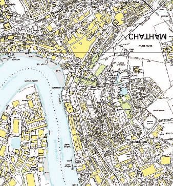
Rochester (via Chatham) to Gillingham
DISTANCE: 4.6 miles (7.4km) • LEVEL OF DIFFICULTY: Easy • MINIMUM TIME: 2 hours (approx)
cross the bridge the path turns right into the esplanade Turning back towards Rochester High Street, England’s second
A past the Bridge Chapel and on towards the castle (18). oldest cathedral (20) stands ahead. Founded in 604 by Bishop
Begun in 1087 by Bishop Gundulf, who used what remained Justus, the present building was started in 1080 by Bishop
of the original Roman structure, it is one of the earliest stone Gundulf and consecrated on Ascension Day 1130. It was here
castles built in England. The imposing keep was added by also in 1540 that Henry VIII first met Anne of Cleves.
William De Corbeil, who was granted custody of the castle
by Henry 1 in 1127. Turn up into Bakers Walk, where on Retaining an atmosphere of real peace, it contains several
your right you will come across Satis House. Though much fine medieval wall paintings as well as many wonderful
altered, this was once the home of Richard Watts who built sculptures and carvings including the mysterious Rude Man
The Poor Travellers’ House (19) in the High Street. Elizabeth above the main entrance door. Minor Canon Row is a terrace
l stayed here in 1573 and is said to have expressed her of early 18th century clergy houses. Number two was the
gratitude with the latin word satis meaning ‘enough’. early home of the actress Dame Sybil Thorndike and her
256 WALK Rochester to Gillingham
brother Russell, who wrote the Dr Syn smuggling novels. Continuing up to Star Hill,
The street also appears in Charles Dickens’ last unfinished the path then crosses
novel The Mystery of Edwin Drood. Jacksons playing field where
it climbs up towards Fort Pitt
The path then continues through the Vines, once the site of Hill. Standing on the hill on
the cathedral monks’ vineyard. Facing the park on your left your right, is Fort Pitt
stands Restoration House (21) see previous map. This is an Grammar School for Girls.
impressive Elizabethan Mansion where Charles II stayed on This was originally built
the eve of his restoration in 1660. Beautifully restored, it is between 1805 and 1819 as
occasionally open to the public during the summer. The area part of the extension
to the south of here is known as Troy Town and is believed by eastwards of the dockyard defences known as the Chatham
some to have once been the site of an ancient turf maze. Lines. By 1828 it had become a hospital and in 1860
Florence Nightingale started the first Army Medical School
here. Victoria Park next door offers superb views across the
Medway as you descend into New Road, built in 1772.
This was an alternative route between Rochester and Chatham
and used by Vincent Van Gogh in 1876 on his journey from
Ramsgate to London.
A small detour from the bottom of Hammond Hill will take
you to St Bartholomew’s chapel (22). Now redundant, it was
built in 1078 as part of Bishop Gundulf’s hospital which
moved to its current location in New Road in 1863.
Opposite the chapel stands the Sir John Hawkins’ hospital
26Rochester to Gillingham WALK 6
founded in 1594 and rebuilt in 1789. Originally for poor From the pier, continue towards Chatham to Globe Lane and
mariners, their wives and widows, the building still provides the tree lined area known as the paddock. This was once used
sheltered accommodation. The walk along the High Street for grazing sheep. It stands in front of the old town hall, which
may seem rather unimpressive, but look above the shop fronts is now used as The Brook Theatre (23). Opened by Lord
and a wide range of late Georgian and Victorian buildings are Roseberry in January 1900, it stands on the corner of The
revealed, many awaiting sympathetic restoration. As you turn Brook. As the name implies, this was once a waterway, now
into Medway Street follow the sign to Sun Pier. This was built buried deep beneath the existing road. The area next to the
in 1885 replacing an earlier structure on the same site. river originally formed part of the dockyard and was known as
With excellent views across the river, it was here that artist Gun Wharf. For many years it was omitted from Ordnance
Richard Dadd, born in Chatham in 1817, painted one of his Survey maps and surrounded by a high brick wall.
earliest pictures of Medway still in existence. Although many
of his later paintings, completed while incarcerated in A short detour from here using the path next to St Mary’s
Broadmoor and Bethlem Hospital for the murder of his father, church, brings you to the Command House (24), originally
incorporated his memories of local scenes and buildings. the residence of the officer in charge of ordnance facilities,
276 WALK Rochester to Gillingham
but now a riverside public house. St Mary’s (25) was originally spent part of his training as a royal engineer in Chatham.
the parish church for the medieval village of Chatham. Between 1921 and 1958 the statue stood in Khartoum, before
Extensively rebuilt over the years, today it bears little being re-erected here in 1960. As you head towards Brompton
resemblance to its original design. and just beyond the barracks that bear Lord Kitchener’s name,
look out on your right for the 19th century colonading,
Across the road stands Fort Amherst (26), built as a result of the originally part of the entrance to the Soldiers’ Institute and
devastating Dutch raid in 1667, though construction work didn’t Garrison Club. This raised section of path also offers fleeting
actually begin until 100 years later. Unlike many forts of the views across the river towards Rochester.
period, it remained unaltered during the 19th century and is one
of the best remaining examples of Georgian military architecture. Before turning right up the steps to Brompton, ahead of you
From the fort continue past the statue of Lord Kitchener, who across the road, stands The Historic Dockyard’s (27) main
28Rochester to Gillingham WALK 6
entrance. Above the entrance is the royal coat of arms for stands The Royal Engineers Museum, which traces the history
George I. The closure of the dockyard in 1984 ended nearly of military engineering as far back as 1066. Just beyond the
400 years of continuous use as an active naval base. museum is the new MidKent College, opened in 2009.
Much of the site has now been re-developed, but the area
beyond the main gate remains virtually untouched, with a wealth Upon reaching the next pedestrian crossing, continue across
of 18th and 19th century buildings among its attractions. then uphill along Mill Road until you reach Saunders Street.
Turn left here and continue along what originally formed
Proceed up the steps into Brompton, built mainly in the 18th part of Church Path (also once known as Twelve Stile path),
century to house troops protecting the dockyard. A number of an ancient route between Brompton and St Mary’s Church.
the area’s original Georgian properties remain, including The On reaching Victoria Street, turn left and head down to its
King George V public house, known originally as The Prince junction with Burnt Oak Terrace. From here, turn right and
of Orange. Continue along Garden Street, until you reach the cross over the disused railway line that once served the
crossroads. Turn left and go down Mansion Row, where upon dockyard, then into Parr Avenue. Once again the route
reaching Wood Street you turn left again, before using the becomes part of Church Path until it reaches Ingram Road.
pedestrian crossing to reach the other side. Turn right and Crossover and turn left along Church Street, before turning
head towards the traffic lights, where the path turns down into right into Gillingham Green, where ahead of you stands
Prince Arthur Road. To your left and throughly recommended St Mary’s Church ■
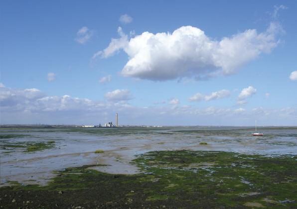
29WALK 7
Gillingham to Upchurch
DISTANCE: 5.3 miles (8.5km) • LEVEL OF DIFFICULTY: Easy • MINIMUM TIME: 2 hours (approx)
illingham began life has a small fishing village and is first
G mentioned in the Domesday book in 1086 as Gelingeham.
Its origins lie in the area around St Mary’s Church (28), which is
dedicated to St Mary Magdalene. In the Middle Ages, a figure of
Our Lady of Gillingham was believed to work miracles, but it is
likely that this was an elaborate tale for the benefit of pilgrims
on the way to the tomb of St Thomas Beckett in Canterbury.
It was also here that Will Adams, possibly Gillingham’s most
famous inhabitant, was baptised in 1564. His exploits in Japan
formed the basis of James Clavell’s historical novel Shogun,
317 WALK Gillingham to Upchurch
later made into a popular TV series. From the church, the path
descends down into Grange Road. Turn left here through the
graveyard gates and follow the path down to its junction with
Layfield Road. Turn right and continue along the road until its
junction with Court Lodge Road. Turn left here heading towards
the railings, where you turn right along the path running next
to Gads Hill, derived from the old English Godes Hill, meaning
a pagan place of worship. Use the pedestrian crossing to reach
Waterside Lane, almost directly opposite of you. Continue
straight ahead down the lane, through the modern housing
development until you reach the foreshore. In the distance
beyond the hulks of disused barges, stand the island forts of
Hoo (29) and further east, Darnet (30). Between the forts and
dominating the skyline is Kingsnorth power station.
To your left a short detour along the path, will lead you past
the Medway Cruising Club to the Strand, an outdoor leisure
area first opened in 1896. Should you decide to make the
detour, look out for the two remaining houses from the area’s
days as a small fishing community.
Turning right, continue along the path to Owen’s Way passing
between several factories, before returning through the trees to
the water’s edge and Copperhouse marshes. The name is a
32Gillingham to Upchurch WALK 7
reference to the area’s 19th century copperas works. A form To your left in the distance,
of iron sulphate, it was used both in the woollens and dyes is the peninsula known
industries, as well as being a key ingredient in the production (from the late 19th century
of nitric and sulphuric acid. Continue along the path towards onwards) as Horrid Hill (33),
Riverside Country Park, passing the area to your right known which provides excellent
as Eastcourt Meadows (31). A haven for butterflies and panoramic views of the
wildflowers, it was until the 1950s the site of a municipal estuary and is an ideal
rubbish tip. location for birdwatching.
It is also on occasions,
Once across the car park at Sharps Green Bay, take a moment possible to spot common
to visit the pond (32) to your right, a great area to spot wildlife seals here at high tide. Originally an island it was later
such as dragonflies, frogs and even kingfishers. Back on the connected to the mainland by a causeway, to allow a
path, follow the waymarked route through the park until it horse drawn railway to reach the cement works, which
once again hugs the shoreline. once stood there.
337 WALK Gillingham to Upchurch
To your right and almost hidden behind grassy mound, is the
park’s visitor centre (34). This provides an ideal opportunity
to relax, buy refreshments and learn more about the area.
The path continues alongside the estuary to Bloors Wharf,
once a breakers yard for boats and now part of the country
park. Stay on the path until you reach a small car park
where it turns left. From here the path heads towards Motney
Hill, a sandy rise projecting out into the river. To your right
are the Motney reed beds (35), which provide a valuable
springtime breeding ground for birds such as moorhen, coot
and reed warbler.
Upon reaching the gates of the sewerage works, cross over
the road and follow the path around the edge of Otterham
Creek. Towards the path’s end it runs next to a small orchard
before finishing just outside of the local authority boundary
at Otterham Quay ■
34Further information
Medway Council Rights of Way 01634 333333 www.medway.gov.uk
Medway Visitor Information Centre 01634 338141 www.medway.gov.uk
Medway and Swale Estuary Partnership 01634 338891 www.msep.org.uk
Explore Kent 08458 247 600 www.kent.gov.uk/explorekent
Natural England 0845 600 3078 www.naturalengland.org.uk
RSPB 01767 680 551 www.rspb.org.uk
The Ramblers Association 020 7339 8500 www.ramblers.org.uk
National Rail 08457 48 49 50 www.nationalrail.co.uk
Traveline 0870 608 2 608 www.travelinesoutheast.org.uk
36Suggested further reading The Saxon Shore Way - Alan Sillitoe and Fay Godwin - Hutchinson 1983 The Saxon Shore Way (Recreational Path Guide) - Bea Cowan - Aurum Press 1996 Circular Walks along the Saxon Shore Way - Kent County Council 2006 The Gillingham Chronicles: A History of Gillingham - Ronald Baldwin - Baggins Book Bazaar 1998 Chatham Past - Philip MacDougall - Phillimore and Co Ltd 1999 Great Expectations - Charles Dickens - Originally published in serial form between 1860 and 1861 Waterlog - Roger Deakin - Vintage 2000
Published by Medway Council Development and Environment
Department in association with Medway Swale Estuary Partnership.
Text: Medway Swale Estuary Partnership.
Photography: Mark Loos, pinhole photography: Dave Wise.
Designed by Medway Council’s Communications Team. G2907
www.medway.gov.uk/communications
Copyright 2010 Medway Council. All rights reserved.

All maps in this publication are reproduced/based upon the Ordnance Survey mapping
with the permission of Her Majesty’s Stationery Office © Crown Copyright. Unauthorised
reproduction infringes Crown Copyright and may lead to prosecution or civil proceedings.
Medway Council Licence No.-09070L 2000.
You can also read