WALKING TRACKS IN AORAKI/MOUNT COOK NATIONAL PARK - DOC
←
→
Page content transcription
If your browser does not render page correctly, please read the page content below
Walking tracks
in Aoraki/Mount Cook
National Park

Contents
Welcome to Aoraki/Mount Cook National Park               1

Be prepared                                             3

Walks from the village and campground                   5

Freda du Faur                                           9

Walks map                                               10

Village walks map                                       12

Walks in Tasman valley                                  14

Cycling                                                 16

Nature walking and wild-flower spotting                 18

                                                             Welcome to Aoraki/
                                                             Mount Cook National Park
                                                             Enjoy one of our walks or hikes around the village and
                                                             environs; ranging from 10 minutes to 4 hours – there
      Check, Clean, Dry                                      is something to suit everyone’s ability. For those with
      Stop the spread of                                     moderate fitness, there are options for even longer day
      didymo and other                                       walks or overnight tramps:
      freshwater pests.                                      to Mueller Hut (3–5 hr one
      Remember to Check,                                     way), which offers an amazing         If you are doing an
      Clean, Dry all items                                   chance to experience the           overnight walk, you will
      before entering,                                       alpine environment without           need to sign in at the
      and when moving                                        being a climber, or to Ball           DOC Visitor Centre,
      between, waterways.                                    Shelter (3–4 hr one way) for         and pay your hut fees
                                                             breathtaking views over the               before you go.
                                                             Haupapa/Tasman Glacier and
Published by:                                                beyond.
Department of Conservation
Aoraki/Mt Cook National Park
Visitor Centre
                                                             Aoraki/Mount Cook National Park
PO Box 5                                                     Aoraki/Mount Cook National Park (70,696 ha) is New
Aoraki/Mt Cook 7946
                                                             Zealand’s great alpine park, boasting the highest mountains
New Zealand
June 2018                                                    and the largest glaciers in the country. The area was
Editing and design:                                          formally established as a national park in 1953 and is a harsh
Creative Services                                            land of ice and rock. Glaciers cover 40% of the park. There
DOC National Office
                                                             are 19 peaks over 3,000 metres high, including of course
This publication is produced using paper sourced from
well-managed, renewable and legally logged forests.
                                                             New Zealand's highest mountain, Aoraki/Mount Cook.
R136827

                                                                                                                           1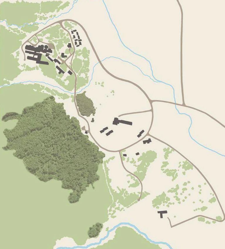
The park is also recognised for its outstanding natural
values and forms part of the internationally celebrated        Be prepared
Te Wāhipounamu – South West New Zealand World
Heritage Area.                                                 Remember – your safety is your responsibility
                                                               Choose a track that suits your fitness and experience.
Glacier country                                                Follow the Outdoor Safety Code:
The glaciers that have helped shape the park's landscape           • Plan your trip
include five major valley systems: Godley, Murchison,              • Tell someone your plans
Tasman, Hooker and Mueller. There are also over 150                • Be aware of the weather
named smaller hanging glaciers on the mountainsides,               • Know your limits
which add to the dramatic landscape.                               • Take sufficient supplies
Haupapa/Tasman Glacier, New Zealand's largest and              For more information, visit: www.mountainsafety.org.nz.
longest glacier, is clearly visible from the main highway at   We recommend you carry the appropriate NZTopo maps for
the entrance of the park. It is 27 kilometres long, up to      the longer tracks in this brochure.
3 kilometres wide and extends over 100 square kilometres.
Although covered with rock material in its lower reaches,      To make your trip as enjoyable as possible, make sure you
the ice of the Tasman is about 600 metres deep near the        have the correct clothing and supplies for your activity. We
Hochstetter icefall.                                           recommend you take:
                                                                      Sturdy shoes
                                                                      Suitable headwear for the season and conditions
                                                                      Extra warm clothing
                                                                      Waterproof jacket
                                                                      Water and food
                                                                      First aid kit
                                                                      Sunscreen all year round
                                                                      Insect repellent (in summer months)
                                                                      Camera

                                                                 Beware
                                                                    • The weather can change quickly here – high
    The naming of a mountain                                          winds are common and snow can fall at any time
    The mountain from which Aoraki/Mount Cook                         of year. Check the weather forecast regularly.
    National Park takes its name was originally named               • Snow and ice conditions can be treacherous.
    Aoraki by Ngāi Tahu, the first settlers in the area.              Always walk with care over snow or ice.
    It received its European name, Mount Cook, in                   • Avalanches can occur any time of the year but are
    1851 from Captain J.L. Stokes, who first sighted the              most common in winter and spring. Take special
    impressive peak as he sailed down the West Coast.                 care when travelling through known avalanche
    Stokes named the mountain in honour of the English                areas and check avalanche advisory.
    navigator and discoverer of New Zealand, Captain
                                                                    • The alpine areas in the park are very exposed, and
    James Cook.
                                                                      at any time of year, spending a long time in the
    In 1998, both names were officially recognised and                sun or in hot conditions can lead to dehydration
    the mountain is now known as Aoraki/Mount Cook.                   and severe sunburn – go well prepared.

2                                                                                                                             3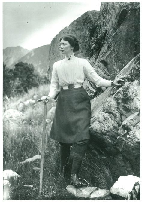
Enjoy
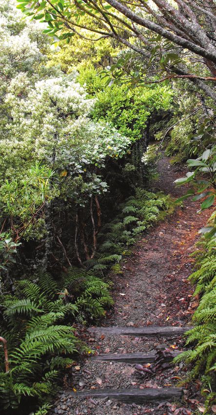
Walks from the village and campground
nning scenery
• Stu •w
id
e
Governors Bush Walk
Time 1 hr return (loop track)
-o
pe
Grade Short walk: Easy
ns
Start place
pa
Public shelter
ces
Height gain 100 m – steps plus well-gravelled track
•b
rea
A delightful bush walk that joins with Bowen Bush Walk
tht
ng to form a nature trail and explores one of the few stands of
ak
i
su silver beech/tawai (also known as tawhai) forest in the park.
Ph nris
oto
:D
ecla es and sunsets A gradual climb leads to a lookout point of Wakefield Ridge
n Wong
and Aoraki/Mount Cook. This popular walk offers birdlife,
a great view of the mountains and a sheltered place to
s
rm
experience the outdoors in poor weather.
ca to
ls
ra tri Bowen Bush Walk
•d
ma c
tic ele
wea rilling ions Time 10 min return (loop track)
ther e h t
vents, including t forma Grade Short walk: Easy
u d
and impressive clo Start place Opposite petrol pumps
Height gain Predominantly flat with some steps
• glaciers – lots of them,
from hanging to valley floor; An easy forest walk that can be joined with Governors
from pearly w y Bush Walk to form a nature trail. This track wanders
hite to gravel gre through tōtara and celery pine/mountain toatoa forest,
and has an alternative exit/entry towards the Mount Cook
ildflowers Lodge. In summer a ‘Bird Song’ sounds system enhances
ing•w
az the experience.
targ
rs
ies fo
sk
• clear night
4 5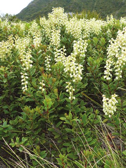
Glencoe Walk                                                    Kea Point Track
Time              30 min return                                 Time              2 hr return from the village
Grade             Short walk: Easy                                                1 hr return from White Horse Hill
Start place       Behind The Hermitage hotel                                      Campground and car park
Height gain       40 m – steps and some zigzags                 Grade             Walking track: Easy
                                                                Start place       DOC Visitor Centre and cross over the
This walk zigzags through tōtara trees with a ferny                               road towards Hooker valley
understorey, emerging at a lookout near the prominent           Height gain       180 m over 3 km
water tanks above The Hermitage. A short climb rewards
with a bird’s-eye view of the village and beyond to the white   This walk gently winds its way through subalpine
ice of Hooker Glacier and Aoraki/Mount Cook. Sunrise            grasslands and scrub to the Mueller Glacier moraine wall.
and sunset are good times to catch the light playing over       The track passes through a landscape that was formed in
the mountains.                                                  1913 when a stream cut through from the glacier to the
                                                                original Hermitage site, damaging the building. The walk
Red Tarns Track                                                 ends at a viewing deck that gives stunning views of Mount
                                                                Sefton, The Footstool, Hooker valley, Mueller Glacier lake
Time              2 hr return                                   and Aoraki/Mount Cook.
Grade             Walking track: Steep and mainly stepped
Start place       Public shelter                                Sealy Tarns Track
Height gain       300 m                                         Time             3–4 hr return
Follow the track downhill from the public shelter to cross      Grade            Walking track: Steep and stepped
the bridge over Black Birch Stream and then climb steeply       Start place      As for Kea Point Track, then branch off
to the Red Tarns. The vegetation changes as you ascend                           at the signpost
from the valley floor to a superb panoramic viewpoint of        Height gain      600 m
the valleys below, the village and Aoraki/Mount Cook. The
                                                                Dubbed the 'stairway to heaven', 2,200 steps take you
tarns are named for the red pond weed that grows in them.
                                                                straight up to the freshwater lakes of Sealy Tarns. This
An aptly placed seat allows you to recover your breath
                                                                energetic walk provides spectacular views of the Hooker
and enjoy the views. This is a magnificent spot to view the
                                                                valley and peaks of the area, including Aoraki/Mount Cook.
sunset in summer.
                                                                An abundance of alpine flowers in summer and the views
                                                                from the tarns make the effort worthwhile. The tarns are the
                                                                halfway point to Mueller Hut.

6                                                                                                                            7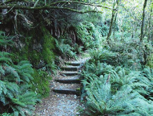
Hooker Valley Track
Time              3 hr return (add 1 hr                         Freda du Faur was the first woman to climb
                  if starting from the village)                 Aoraki/Mount Cook. She accomplished this amazing
Grade             Walking track: Easy                           feat in 1910 with the help of two guides, brothers
Start place       As for Kea Point Track, or start at White     Alex and Peter Graham. In 1913, Freda completed
                  Horse Hill Campground and car park            the first Grand Traverse (all three peaks) of Aoraki/
Height gain       80 m over 5 km                                Mount Cook with guides Peter Graham and Darby
                                                                Thompson. Freda’s Rock is the site where her now-
The best time to walk this stunning track is at dawn when       famous photo was taken just after her first successful
the first rays of sun creep over the Southern Alps, including   ascent of the mountain. For further information, visit
over New Zealand’s highest peak, Aoraki/Mount Cook, and         the Aoraki/Mount Cook DOC Visitor Centre.
there are fewer walkers.
The track leads up the Hooker valley towards Aoraki/
Mount Cook. It passes close to the Alpine Memorial (a great
viewpoint) and Freda’s Rock before coming to the viewing
point of the Mueller Glacier and the first swing bridge.
Cross the Hooker River here and carry on to the second
swing bridge. Look out for many different wildflowers along
the way, including celmisia and the Mount Cook buttercup/
kōpukupuku.
The track from the first swing bridge to the second travels
between old moraine ridges and humps. Past the second
bridge, the vegetation changes to more open tussock and
a wider valley floor. A third swing bridge leads to the east
Hooker and the source of the Hooker River. The track ends
at the glacier lake, where there are amazing views of Aoraki/
Mount Cook, Hooker Glacier and the Southern Alps/
Kā Tiritiri o te Moana.
Return the same way, enjoying more views down the valley
and across to the Sealy Range.

8                                                                                                                        9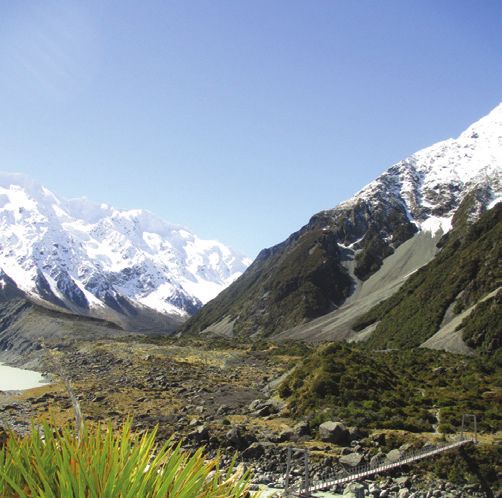
KEY TO SYMBOLS                         Mueller Hut Route
    Car park                           Time            3–5 hr one way
    Toilets                            Grade           Tramping track:
    Shelter                                            Steep and untracked
                                                       In winter: route
    Campsite
                                       Start place     As for Sealy Tarns Track
    Hut                                Height gain     1,000 m
    Information                        We recommend NZTopo50 BX15 map for
    centre          1030 m             this route.
    Road
                                       Spectacular panoramic views, a large
    State highway
                                       hut and amazing landscapes are the
    National Park                      drawcards for this strenuous walk.
    boundary
                                       During the summer months (December
                                       – February) this route offers a mountain
                                       experience for anyone with moderate
                                       tramping experience – if you take good
                                       care. During the winter months (June –
                                       August) the route requires a good level
                                       of mountaineering experience, including
                                       walking on ice and snow with ice axe and
                                       crampons, route finding, and using an
                                       avalanche transceiver, probe and shovel.
                                       Check with the DOC staff at the Aoraki/
                                       Mount Cook Visitor Centre for current
                                       mountain conditions.
                                       During the summer months, you can
                                       book this hut online at www.doc.govt.nz.
                                       In winter, you need to call in to the
                                       Aoraki/Mount Cook Visitor Centre to
                                       sign into the park’s intention system and
                                       pay hut fees before heading to the hut.

                             Track grades
                             Short walk: well-formed track, easy walking for
                             up to an hour.
                             Walking track: track is mostly well formed, easy
                             to moderate walking from a few minutes to a day.
                             Tramping track: track is mostly unformed,
                             challenging day or multi-day tramping/hiking.
                             Route: unformed track, challenging overnight
                             tramping/hiking, suitable only for people with
                             high-level backcountry skills and experience, and
                             navigation and survival skills.
                                                                             11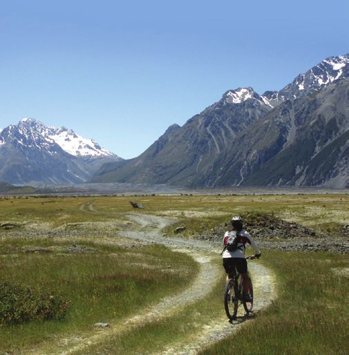
12 13
Tasman Lake is a relatively recent addition to the scene,
Walks in Tasman valley                                          starting its formation in 1974 and growing steadily since
                                                                then. It is now large enough to take commercial boat and
                                                                kayak tours. The large terminal moraines mark the foot of
     Blue Lakes and Tasman                                      the Tasman Glacier at the time of the lake’s formation and
     Glacier View Track                                         are a sobering reminder of the glacier’s retreat.
     Time              40 min return                            Ball Hut Route
     Grade             Walking track: Easy with steps
                                                                Time               3–4 hr one way
     Start place       Blue Lakes car park
                                                                Grade              Tramping track: first section easy, can be
     Height gain       100 m
                                                                                    a challenging route from the end of the
     From the car park, walk past the Blue Lakes shelter                            4WD track. In winter: all a route
     and meander up past the Blue Lakes to a viewpoint          Start place        Blue Lakes or Celmisia car parks
     on the moraine wall. There are good views of the           Height gain        100 m over 9 km
     lower Tasman Glacier and lake, icebergs and the            We recommend NZTopo50 BX15 (4WD section) and BX16
     mountains at the head of the valley. A side trip to        (route to Ball Hut) maps for this route.
     the Blue Lakes offers good swimming in summer.
                                                                The first 5-km section of this track follows a historical road,
     At around 27 km                                            now a 4WD track. It opens up to spectacular views after the
     long, the Tasman                                           end of the 4WD track, but the route becomes more difficult.
     Glacier is the
                                                                The moraine wall throughout this area, including along the
     longest glacier
                                                                4WD track, is very unstable and should be negotiated with
     in New Zealand.
                                                                caution. You will need to move with care and skill around
     The glacier lake
                                                                collapsed areas at various stages along the route.
     has been growing
     rapidly over the                                                                             Ball Hut is close to the
     past few years and                                                                           historic site of the first Ball
     is now around 7 km                                                                           Hut and offers superb views
                                                                            Sign in at
                                                                                                  of the Tasman Glacier and
                                                                        the DOC Visitor
                                                                      Centre if you wish to       surrounding peaks.
Tasman Lake Track                                                     stay at Ball Hut, and
                                                                      pay your fees before
Time               50 min – 1 hr return                                    departing.
Grade              Walking track: Easy
Start place        Blue Lakes car park
Height gain        None
This walk branches to the right off the Blue Lakes Track
just past the Blue Lakes Shelter and leads to a viewpoint of
the Tasman Glacier terminal lake. A further track branches
to the right off this track to go to the source of the Tasman
River. Icebergs can usually be seen floating in the lake in
summer, and in winter the lake freezes over. The track leads
through the old terminal moraines of the glacier, and you
can see good examples of plant succession along the route.

14                                                                                                                            15
Cycling
                                                NOTE:
                                          Cycling is allowed
Hooker valley                          only on the Alps 2 Ocean
Distance           2 km      EASY
                                      Cycle Trail and on formed
Grade              Easy/Grade 2       roads in the national park.
Start place       Aoraki/Mount Cycling is NOT ALLOWED
                  Cook village –     on the walking tracks          Alps 2 Ocean Cycle Trail (national park section)
                  veer left at            in the park.              Distance           5 km                                   EASY

                  Hooker Valley Road                                Grade              Easy/Grade 2 – downhill to the airport
                  intersection                                      Start place        Aoraki/Mount Cook village – as for the
Height gain        50 m                                                                Tasman valley, then take the
                                                                                       Alps 2 Ocean Cycle Trail at the Hooker
This cycleway runs alongside Hooker Valley Road to the
                                                                                       River road bridge
White Horse Hill Campground and car park. It provides
                                                                    Height loss        60 m
stunning views of the Southern Alps/Kā Tiritiri o te Moana
along its length.                                                   It’s all downhill to the airport on this section of the Alps
                                                                    2 Ocean Cycle Trail! Make sure you stop and take a look
Tasman valley                                                       behind you from time to time to view the Southern Alps as
Distance           8.5 km                                  EASY
                                                                    you spin down the Tasman valley.
Grade              Easy/Grade 2                                     This is the first section of the Alps 2 Ocean Cycle Trail,
Start place        Aoraki/Mount Cook village – veer right           which leads all the way to Oamaru. From the airport, you
                   at the Hooker Valley Road intersection           need to take a short helicopter ride across the valley to
                   and head towards the Tasman valley               continue on the cycleway through to Twizel and beyond.
Height gain        100 m
This cycle trail takes cyclists out to the Blue Lakes car
park in the Tasman valley. Follow the Alps 2 Ocean Cycle
Trail from either the White Horse Hill Campground or the
Aoraki/Mount Cook village as far as the road bridge on
the Tasman Valley Road. Cycle along the Tasman Valley
Road to the Blue Lakes car park. Take care as the road can
be busy with cars and buses. From here, leave your bikes
and walk to the Tasman Glacier viewpoint or lake, where
you will be rewarded with expansive views of the glacier,
moraines and the river winding its way along the valley floor.

16                                                                                                                              17
Nature walking and wild-flower spotting
Pick up the Nature-trail guide and visit one of the short
walks in the village for a true nature-trail experience. Use
the guide, the plant labels through both Governors and
Bowen bush walks, and the Bowen Bush ‘Bird Song’ sounds
system in Bowen Bush to help you identify the plants and
birds in the park.
Wild flowers abound from October to March, and the
Hooker Valley Track is a great place to see these.
Look out for: New Zealand falcon/ Rifleman/tītitipounamu
Photo: M F Soper
kārearea
Photo: D Busbridge
Grey warbler/riroriro
(more commonly heard
than seen) Photo: M F Soper
Paradise shelduck/pūtakitaki
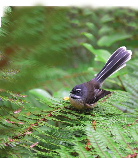
Fantail/pīwakawaka
Kea
Photo: S Jackson
Tomtit/miromiro
Photo: A Fleming
18 19Gentian Large mountain
Black mountain daisy/tikumu
ringlet butterfly
Common copper butterfly
Photo: G W Gibb
Bush snowberry
Photo: S Mankelow
Red admiral butterfly
Mount Cook
buttercup/
Boulder copper Southern kōpukupuku
butterfly Photo: R Morris Alps gecko
Photo: M Lettink
Paper daisy
Photo: J H Johns
WARNING
In summer, the native
tutu shrub flourishes
Common skink throughout the Hooker
valley walks.
All parts of this plant,
including berries, contain
a poison called tutin.
DO NOT EAT ANY TUTU
BERRIES AND WASH
YOUR HANDS AFTER
TOUCHING ANY PART
Spaniard/ OF THE PLANT.
taramea
20 21Travelling with children? Check out the Toyota Kiwi Guardians programme at www. doc.govt.nz/kiwiguardians, or talk to the DOC Visitor Centre staff. Further information Aoraki/Mount Cook National Park Visitor Centre 1 Larch Grove Aoraki/Mount Cook Phone: 03 435 1186 Email: mtcookvc@doc.govt.nz www.doc.govt.nz Alps 2 Ocean Cycle Trail www.alps2ocean.com
You can also read