What is and What is not the Digital Earth?* - CEUR-WS.org
←
→
Page content transcription
If your browser does not render page correctly, please read the page content below
What is and What is not the Digital Earth?*

                           Eugene Eremchenko[0000-0002-4416-7617]

           Lomonosov Moscow State University, Moscow GSP-1, 119991, Russia
                       eugene.eremchenko@gmail.com

       Abstract. The article addresses to a fundamental issue facing the concept of the
       Digital Earth in 2020 – what is the definition of the Digital Earth? 22 years after
       the announcement of the concept and 15 years after its first mass and successful
       implementation in the service Google Earth in 2005 this question remains unan-
       swered. In the article the current status of the development of the Digital Earth
       concept by 2020 is considered, a methodology for the definition of the Digital
       Earth, based on the classification of the diversity of existing geospatial ap-
       proaches and the identification of key factors that provide its unique function-
       ality, is proposed and discussed. Distinction between the Digital Earth and oth-
       ers geospatial approaches is provided. The intrinsic connection of definition and
       classifications is grounded, the new definition of the Digital Earth and compli-
       mentary classification of geospatial methods are offered. Semiotics aspects of
       the Digital Earth are discussed briefly. The question of the eligibility of tech-
       nologies and systems to the Digital Earth is considered. The perspective issues
       of further development of the Digital Earth are considered.

       Keywords: Digital Earth, Visualization, Typology, Cartography, Semiotics.

1      Introduction
In 2020 the Digital Earth initiative, first introduced by U.S. Vice President Albert
Gore in 1998, turned 22 years old. Digital Earth was being promoted as a new, revo-
lutionary approach to handling geospatial information with fabulous functionality,
and as a core of the new smart response and effective governance policy that will of-
fer many benefits to all mankind. In his well-known speech [1] Gore envisioned and
highlighted two milestone years in future development of new concept – 2005 and
2020: “What we will be able to do in 2005 will look primitive compared to the Digital
Earth of the year 2020”.
   The prediction appeared to be remarkable. The year 2005 was indeed a turning
point in the development of the Digital Earth and marked the beginning of the "geo-
spatial revolution" with the unveiling of Google Earth [2] – the first service that fully

Copyright © 2020 for this paper by its authors. Use permitted under Creative Commons Li-
cense Attribution 4.0 International (CC BY 4.0).

* Supported by RSF grant #20-47-01001 (data analysis, investigations, discussion and conclu-
sions) and by RFBR grant #18-05-00236 (selections and review of the raw materials).
2 E. Eremchenko embodied this concept and gained extreme popularity. Until now, Google Earth re- mains the most striking implementation of the ideas behind the Digital Earth concept. In 2020, as Gore presumed, the Digital Earth should go far ahead, and the achieve- ments of 2005 against its background should seem primitive. Today, in 2020, we have an opportunity to check the accuracy of the second part of his forecast, but the situa- tion looks ambiguous. In 2020, the current status of the concept of the Digital Earth seems to be at least contradictory. That is the reason why the year 2020 is particularly suitable for checking the current status of the development and implementation of the Digital Earth concept and defining plans for the future. On the one hand, the geospatial revolution has become a fact of our life and had an irreversible impact on all mankind. Now the Digital Earth is officially recognized throughout the world and has already established itself as a best approach for working with geospatially located data. Digital Earth has gained huge popularity and widely implemented with remarkable results. Google Earth, the clearest example of the new concept, was downloaded more than billion of times six years after its launch [3]. One year after the launch of the Google Earth, in 2006, the International Society for Digi- tal Earth (ISDE) was established [4]. 11 Digital Earth Symposiums [5] and 7 Digital Earth Summits [6] were held around the world up to this moment – the largest and most authoritative international forums dedicated to discussing the scientific para- digm, technological requirements, social benefits and outreach of the concept within rich interdisciplinary context. ISDE scientific activity is concentrated around the well- recognized journals – the International Journal of Digital Earth (IJDE) with 2019 im- pact factor 3,097 [7] and his sister journal Big Earth Data (since 2018) [8] – both pub- lished by the Taylor&Fransis Group. ISDE becomes a member of world leading sci- entific organizations – like International Science Council (ISС), United Nation Com- mittee of Experts on Global Geospatial Information Management -), United Nation Committee of Experts on Global Geospatial Information Management - Geospatial Societies (UN-GGIM GS), Committee on Data of the International Science Council (CODATA), etc. The development of ISDE received a new impetus in mid-2010s with the start of major infrastructure projects directly inspired by the Digital Earth concept and orga- nized under the umbrella of ISDE. China, Australia [9] and Russia [10] have recog- nized the Digital Earth as the basis for national geospatial data policies. It's worth mentioning Digital Silk Road Alliance (DSRA) project, launched in 2016 as a infor- mational backbone of the Road and Belt initiative that covering virtually all of Eura- sia, and the Digital Earth Australia project, launched in 2017 and resulting in a rapid transformation of usual practices of working with geospatial data. For example, one year after the launch of the project Digital Earth Australia, production of official pa- per topographic maps were completely cancelled in that country [11]. Two weeks after its recognition in Australia, Digital Earth was declared as the basis for national policy on space remote sensing in Russia as well. On the eve of 2020, the Manual of Digital Earth [12] – the first detailed and com- prehensive summary of this concept at its current level of development – was pub- lished and shared as open source edition. An open access publication of 852 pages, which outlined the knowledge accumulated to date in the field of Digital Earth and the experience of its use in solving a variety of tasks, has gained amazing popularity - in the first half-year, it was downloaded more than half a million times.
What is and What is not the Digital Earth? 3

    In 2020 the implementation of Digital Earth has become a mandatory requirement
for quality management. The coronavirus pandemic COVID-19 has shown the ex-
treme need of humankind to ensure sustainable development and to implement the
Digital Earth as a state-of-the-art decision making support environment due to its
global extent and scale-less nature. The need for the Digital Earth as a highly effective
tool to support global decision making has reached an unprecedented level.
    On the other hand, scientific and technological progress between 2005 and 2020
has been far more modest than expected 22 years ago. There is a visible and growing
contradiction between, from one hand, the urgent need for the Digital Earth and sus-
tained technological advance – and, from another hand, small and controversial scien-
tific developments in this field. Google Earth still remains the best embodiment of the
Digital Earth concept 15 years after its launch, even though its functionality has been
severely limited and development has virtually ceased [13]. The Digital Earth is de-
veloping in many ways now in an ad hoc manner. Until now, there is no Digital Earth
standard, and even no ultimate basis for its developing – the comprehensive updated
and widely accepted scientific definition of the Digital Earth. The problem looks so
pressing that in 2020 ISDE held a special meeting on the issue of developing a scien-
tific definition of the Digital Earth.
    The lack of definition does not allow to separate the Digital Earth from the variety
of its analogues in the current situation of rapid emergence of new geospatial products
and solutions, which can be difficult to attribute to any particular class. Thus, the dis-
cussion of the current status and prospects of the concept rises the question: what is
and what is not the Digital Earth? Where are the limits of the Digital Earth?
    Obviously, the definition and classification issues are interdependent – definition
provides classification, and vice versa. The resolution of these issues is particularly
important now, since the term "Digital Earth" is often understood in a hardly accepta-
ble broad sense. There is a clear tendency to consolidate under the umbrella of the
Digital Earth everything related to geospatial information, including all components
of the process of creation, storage and use of localized data – remote sensing satel-
lites, communications and navigation, data storages and transmission lines, hardware
complexes and algorithms, mobile applications, etc. This approach, however, ex-
cludes discussion of the obvious novelty of the Digital Earth, because all information
systems are now digital and all information is localized in geospace; it appears that
there is nothing outside the Digital Earth that is obviously wrong. It is therefore im-
portant to undertake a comparative analysis, to identify and compare approaches and
methods that are obviously not relevant to the Digital Earth.
    Discussing the challenges in the development of the concept of the Digital Earth is
particularly important in the context of 2020. Beginning with the second decade of the
21st century, ISDE began to formulate a scientific agenda for the coming decade. The
first declaration Google Earth Vision 2020 was developed in 2011 [14]. The task to-
day is to develop a similar program, Digital Earth Vision 2030, which should address
the problems that have emerged so far. Definition of Digital Earth and recognizing its
place amongst the whole variety of the geospatial approaching became core problem
of the current stage of the development of the concept.
4 E. Eremchenko
2 Methods and research
Many attempts have been made to define the Digital Earth, but Gore's very first defi-
nition of the Digital Earth still appears to be the most successful and effective. He
defined the Digital Earth as “...a multi-resolution, three-dimensional representation of
the planet, into which we can embed vast quantities of geo-referenced data” [1]. In-
deed, the Digital Earth supports different scales of representation of scene and is
three-dimensional, i.e. it allows viewing a scene from different angles. However,
Gore’s definition needs some clarification.
From the point of view of the common user perception, the answer to the question
"what is the Digital Earth" is quite simple – it's a generic term for a variety of prod-
ucts similar to Google Earth. From a historical point of view, this issue also hardly
raises the questions - this is exactly the kind of clearly recognizable product was an-
ticipated in literature many decades before our era. The most striking example is,
probably, the magical "Woland's Globe" from Mikhail Bulgakov's novel "The Master
and Margarita" [15].
Understanding what is the Digital Earth equals to understanding what is not the
Digital Earth. In turn, separation of these too classes produces the classification of
whole variety of the similar approaches within their specific domain and to identify
the relationships between them. To answer this question, it is necessary to define the
domain within which the problem should be solved, and identify its counterparts. We
can assume that this domain is geospatial visualization, because the perception of
space should be visual and, accordingly, can only be provided by means of visualiza-
tion. Within this domain, there are a variety of approaches to the representation of
data - maps, globes, atlases, GIS, 3D-models, as well as new approaches that have
appeared and developed practically simultaneously with Google Earth, but signifi-
cantly different from it.
Albert Gore's definition revealed two key properties of the Digital Earth that can be
used to classify the variety of geospatial products: 1) multi-resolution representation,
and 2) three-dimensional representation. In fact, all geographic maps are confined
inevitably to a certain scale and projection. Both these confinements are fundamental
and determined by the basic cartographic principle. Throughout history, humankind
has dealt only with geographic information confined to a strictly defined scale and
making sense only at that scale. At the same time, this restriction was perceived as
temporary and forced consequence of technical imperfection. Its overcoming in the
future was envisioned, expected and perceived as achievement of the magic horizon
of geography development.
Now this future has become a reality. The Digital Earth is not confined to just one
scale and one projection. For example, in Google Earth the user can change smoothly
and interactively both the view angle of the planet as a whole or the selected scene,
and the distance to it by means of an extremely simple and natural interface. The ex-
istence of two polar geographic products - maps (confined to projection and scale)
and the Digital Earth (free of these limitations) - makes it possible to use the degree of
freedom in terms of scale and viewing angle as classification criteria to systematize
the whole variety of geographic products.
A simple confinement-based analysis unveils four possible types of basic global
geospatial visualizations to be identified (Fig. 1): 1) maps and GIS (regardless of theWhat is and What is not the Digital Earth? 5
type of their media) that incorporate the cartographic principle and confined to specif-
ic scale and specific projection; 2) globes that allow viewing the scene from any per-
spective from the upper hemisphere, but do not allow changing the scale; 3) atlases
and geoportals (cartographic-based solutions that allow selecting the required scale
from a discrete set, but do not allow changing the projection); and 4) Digital Earth,
completely free from restrictions of any kind in user's choice of projection or scale.
The visible representation of the features of these four types can be obtained with the
help of "Angle-Distance" diagrams [16]. Obviously, it is possible to create mixed
products that combine the properties of the first three types. At the same time, the
Digital Earth cannot be combined with other types of geo-visualizations because it is
comprehensive and contains all of them.
Fig. 1. “Angle-Distance” diagram and four basic types of geospatial visualizations.
How should we approach the definition of the Digital Earth based on the proposed
classification? It seems natural to use and clarify the existing definition for this pur-
pose. In doing so, it should be borne in mind that the definition must comply with
generally accepted rules of logic [17]:
1. definition should state the essential attributes of the species;
2. definition must not be circular;
3. definition must be neither too broad nor too narrow;
4. ambiguous, obscure, or figurative language must not be used in a definition;
5. definition should not be negative when it can be affirmative.
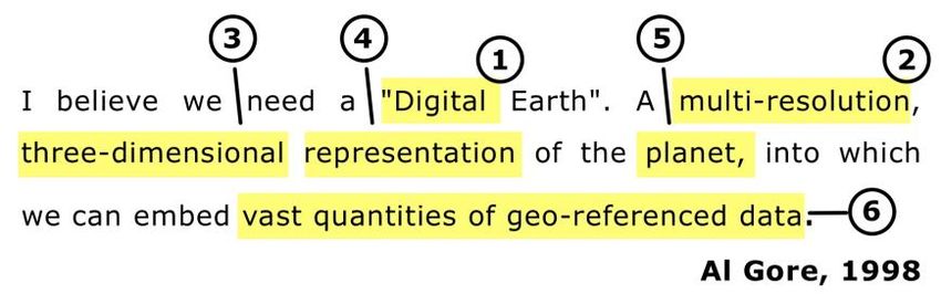
To create a definition of the Digital Earth in accordance with these rules let's consider
the basic definition proposed by Gore in 1998 [1]. It consists of six elements that ex-
presses different properties and features of the Digital Earth (see Fig.2). Accordingly,
it is possible to reveal the meaning of these properties from today's perspective, taking
into account the experience of the first applications in which the principle of Digital
Earth was embodied.
Fig. 2. Elements of 1998 Albert Gore’s definition of Digital Earth to be reviewed, clarified and
refined if necessary.6 E. Eremchenko
1. Digital. The adjective "digital" can refer both to a special type of signs, and
their specific implementation in the computer systems. Here the Digital
Earth is clearly associated with "computer" technologies, which narrows
down the meaning of this term. However, there is no reason to reject the pos-
sibility of realizing it through any other technology. Moreover, the Earth it-
self, as a phenomenon that matching the definition of the "Digital Earth", is
not actually a "digital" phenomenon. Moreover, today all information sys-
tems are "digital" in a computer term, and all information systems ever
known are “digital” in semiotics term. Accordingly, the adjective "digital"
should be regarded as a metaphor for novelty, but not as an essential proper-
ty of the Digital Earth.
2. Multi-resolution. Multi-resolution refers to the presence of several different
resolutions. However, the capabilities of the Digital Earth are incomparably
wider - it contains an infinite number of resolutions, allowing for continuous
and interactive zooming by the user [18]. The ability to provide continuous
zooming is the most impressive feature of the Digital Earth. Therefore, we
can say that in the case of the Digital Earth, we are not dealing with a multi-
resolution, but rather with a scale-less approach.
3. Three-dimensional. 3D-representation means ability to change the direction
of sight smoothly and interactively beyond the limited number of the carto-
graphic projections and even generate absolutely impossible, prohibited by
cartography direction of sight – for example, from bottom to top. Three-
dimensional representation is implemented in the Digital Earth indeed. In
fact, ability to generate any possible direction of sight by user “mirrored”
scale-less property of the real Earth. Therefore, we can say that a projection-
less approach is implemented in the Digital Earth.
4. Representation. Indeed, the Digital Earth as a model (or twin, or replica, or
copy) of the Earth could be regarded as a representation. Moreover, this rep-
resentation does not confined to specific scale and projection and does not
require inevitable and irreversible reducing the raw data to specific scale or
projection.
5. Planet. In the common cartography “representation of the planet” means
representation of the surface of the planet. Instead, the Digital Earth does not
limited by the surface itself. It helps to place and visualize any objects, data,
processes, etc. within geocentric space around the Earth – like satellite con-
stellations, urban canyons, terrain, seabed, cloud formations, etc. Therefore,
the Digital Earth is geocentric model rather than representation of the plan-
et’s surface like map.
6. Vast quantities of geo-referenced data. Indeed, the Digital Earth ables to
collect vast quantities of geo-referenced data. But now any hypertext-based
information system ables to collect same quantities of the same data. The
striking and unique property of the Digital Earth is an ability to provide rich,
contiguous context for any data of any scale (within wide range of accessible
scales), any extent and any direction of sight within geocentric volume that
includes even satellite constellations.
The striking properties of the Digital Earth look quite obvious and natural, be-
cause they mimic the properties of the Earth itself as it percepted by human. ThisWhat is and What is not the Digital Earth? 7
summa of properties was forecasted far before nowadays as a miracle geographical
system of the future [19]. Thus, the question arises - what made it possible to achieve
these obvious properties in the Digital Earth, but not with other geographical instru-
ments?
Albert Gore directly emphasized in his speech that the important or even main fea-
ture of the Digital Earth is the use of images instead of presenting information with
the help of signs: "We have long known that we have trouble remembering more than
seven pieces of data in our short-term memory. That's a low bit rate. On the other
hand, we can absorb billions of bits of information instantly if they are arrayed in a
recognizable pattern within which each bit gains meaning in relation to all the others"
[1]. This statement directly declares that low efficiency of perception of information
is connected with its transmission by means of signs, while much higher efficiency is
reached at use of unsigned tools of information transmission - visual images and,
more broadly, direct sensual perception. The Digital Earth was the first geographic
system that showed the advantage of images over cartographic signs in visualizing the
geospatial environment. Avoiding signs as the primary carrier of geospatial infor-
mation is a key feature of the Digital Earth and ultimate factor of its novelty.
Therefore, we could propose the modified version of the definition of the Digital
Earth:
Definition 1. Digital Earth is a scale-less and projection-less geospatial visualization
of geocentric volume that similar to a real one by the means of incorporating the sign-
less representation of the geospatial context.
The proposed definition is largely empirical because it combines the theoretical pre-
diction of the Digital Earth with the experience of the usage of the applications in-
spired by this concept. As a result, this definition allows a critical discussion about
possibilities of the Digital Earth, its relationships with different approaches to geo-
visualization, and contains significant potential for further interdisciplinary research.
Moreover, this definition includes the vision of the typology of the geospatial visuali-
zations, therefore it makes possible comparative study of the different approaches for
geospatial visualization.
Use of images instead of cartographic signs to represent the geospatial context is a
significant challenge to classical semiotics, which assumes that all information media
must be treated exclusively as signs. Under this approach, all images, such as iconic
images, are supposed to be classified as the most primitive so-called "iconic signs",
while the Digital Earth is to be interpreted as a return from complex and “mature”
signs to more primitive signs.
An alternative point of view indicates that attributing all images, including those
obtained by remote sensing means, to iconic signs generates at least two logical falla-
cies.
1. It leads to violation of “law of parsimony”.
2. It contradicts the idea of artificial nature of signs and, therefore, their histori-
cal development.
In order to resolve a crisis, it must be assumed that information could be transmit-
ted not only by signs but also by other entities that were not signs. It had been sug-8 E. Eremchenko
gested that they should be called "zero signs" [20], because their role in semiotics was
similar to that of zero in mathematics.
In this case, the Digital Earth should be considered a heterogeneous information
system that uses both unsigned media and usual signs to achieve effective perception
of the environment. The "zero sign hypothesis" needs to be critically considered, and
the concept of the Digital Earth itself needs to be studied from a semiotic perspective.
Above considerations allow to separate Digital Earth and its alternatives.
3 Discussion
The use of degrees of spatial freedom for classification of geospatial visualizations
allows to reveal four definite types which fit the internal logic of the historical devel-
opment of the geospatial method. All three alternative modes of geospatial visualiza-
tion: 1) maps, atlases and GIS, 2) geoportals, 3) globes can be fully incorporated into
the Digital Earth; otherwise is impossible. A factor that provides a new quality of
perception in the Digital Earth mode is the use of images instead of signs as the pri-
mary carriers of geospatial context. Any of the four types of geo- visualizations al-
lows to integrate the vast amount of information due to using of hypertext addressing
mechanism, however the quality of its perception will be different. Digital Earth, due
to its rich spatial context is possible to ensure the unrestricted perception of any spa-
tial information in an extremely wide and not limited range of scales and in all possi-
ble diversity of directions of sight.
All geospatial approaches need raw information and the means to obtain it. All
these methods are non-specific and can be used equally (with varying efficiencies) in
any of the geospatial approaches. Therefore, data acquisition tools and related systems
(geodesy and navigation, remote sensing, crowdsourcing, data processing capabilities,
interfaces, etc.) are not the inherent components of the Digital Earth. Instead, Digital
Earth will impact these variety of geospatial means and tools, significantly changing
the ways for data capturing, processing and utilization. Also architecture and configu-
ration of these systems will vary greatly accordingly with the requirements of new
geospatial paradigm.
The same considerations apply to the analysis of the type of information media
used in the Digital Earth and its analogues. The definition of "digital", which was a
symbol of novelty back in the 1990s, has lost its original meaning by the second dec-
ade of the 21st century, since nowadays all information systems have completely or
mainly migrated to the Internet ecosystem and are presented exclusively as computer
("digital") carriers. Nevertheless, the Digital Earth retains its exclusivity, and no other
method of geo-visualization, also implemented through digital technologies, can
match it in its capabilities. This transformation has not affected the essence of the
information systems themselves – they were and still are based on the same signs as
those developed centuries and millennia before the Internet. The revolutionary nature
of the change is due to the fact that, for the first time in history, the Internet has ena-
bled the free circulation of images constructed with the same "digital" signals as an
usial text signs and digits, but simulating direct, non-signatory perception with in-
creasing accuracy. The determinant of "Digital" in the name Digital Earth is historical
– it would be more accurate to call it “Sign-less Earth” instead the “Digital Earth”.What is and What is not the Digital Earth? 9
The relationship between the Digital Earth, its counterparts and supplementary sys-
tems is shown in Figure 3.
Fig.3. Types of geospatial visualizations and supplementary systems. Non-Digital Earth geo-
spatial approaches are dashed.
4 Conclusions
The Digital Earth is one of the four basic types of geospatial visualizations. All other
types of geospatial visualizations - maps, atlases, globes - cannot be considered as the
Digital Earth. Means of gathering geospatial information and other complementary
systems like GNSS, remote sensing and communication satellites etc., cannot be at-
tributed to the Digital Earth in the same way as well.
Digital Earth as a new approach to working with geospatial information is radically
different from the other three, but uses the same sources of information – although its
usage becomes completely different. For example, recreating a sign-less geospatial
context requires a very different implementation of remote sensing orbital constella-
tions. The architecture of control systems is changing, as the elimination of large-
scale image differentiation eliminates the only need for their hierarchical construction.
The Digital Earth no longer fits the paradigm of classic cartography. That is why
understanding the nature of the Digital Earth, forming its scientific definition and
internal development of the Digital Earth as an interdisciplinary scientific paradigm
and relevant methods and technologies are so important.
Also should be noted some unresolved issues:
1. Development of methods for visualization of solid media with a complex in-
ternal structure. This is necessary in order to extend the Digital Earth to rep-
resent areas that cannot be visualized by conventional means - the geology of
Earth, processes in the atmosphere and outer space, etc. In fact interior of the
Earth is the only "white spot" remaining in the modern Digital Earth.10 E. Eremchenko
2. To date, there is no Digital Earth standard that describes its minimum set of
functions without regard to technical facilities and platforms, exchange for-
mats, etc. The development of such a standard is extremely important to en-
sure the systemic development of the Digital Earth.
3. The Digital Earth was the first information system to use unsigned tools to
represent geospatial context. The historical tradition, according to which
signs were the only possible means of information transmission, and the de-
velopment of increasingly complex sign systems, the most important means
of social development, has reversed. The consequences of this turn for socie-
ty have yet to be studied and understood.
4. Digital Earth is an unmatched tool for seamless consolidation of heterogene-
ous social information - for example, medical, biological, environmental, etc.
The development and integration of effective tools for handling social geo-
spatial information in the Digital Earth environment and the adaptation of
management structures to this new tool for sustainable development is an ur-
gent task.
References
1. Gore A.: The Digital Earth: Understanding our planet in the 21st Century,
http://The_Digital_Earth_Understanding_our_planet_in_the_21st_Century.doc last ac-
cessed 2020/07/21.
2. GoogleEarth, https://www.earth.google.com, last accessed 2020/06/12.
3. More than one billion downloads for Google Earth,
https://www.gearthblog.com/blog/archives/2011/10/more_than_one_billion_downloads_fo
r.html, last accessed 2020/06/15.
4. About ISDE, http://www.digitalearth-isde.org/society/54, last accessed 2020/06/12.
5. Symposium, http://www.digitalearth-isde.org/symposium, last accessed 2020/06/12.
6. Summit, http://www.digitalearth-isde.org/summit, last accessed 2020/06/12.
7. International Journal of Digital Earth, http://www.digitalearth-isde.org/publication/70, last
accessed 2020/06/12.
8. Big Earth Data, http://www.digitalearth-isde.org/page/836, last accessed 2020/06/12.
9. Digital Earth Australia, http://www.digitalearth-isde.org/news/805, last accessed
2020/06/12.
10. Digital Earth implemented in Russia, http://www.digitalearth-isde.org/news/810, last ac-
cessed 2020/06/12.
11. Geoscience Australia to stop printing and selling topographic maps from December,
https://www.abc.net.au/news/2019-10-03/geoscience-australia-stop-printing-and-selling-
topographic-maps/11566698, last accessed 2020/06/12.
12. Guo, H., Goodchild, M., Annoni, A. (eds): Manual of Digital Earth. Springer, Singapore.
(2020).
13. Sad Lack of Visible Progress on Google Earth for Chrome and Mobile One Year Later,
https://www.gearthblog.com, last accessed 2020/06/12.
14. Digital Earth Vision 2020, Workshop, http://www.digitalearth-isde.org/ssw/147, last ac-
cessed 2020/06/12.
15. Bulgakov, M.: Master and Margarita. Transl. by Glenny, M. Collins and Harvill Press.
London (1967).What is and What is not the Digital Earth? 11
16. Baturin, Yu., Eremchenko, E., Zakharova, M.: 3D-document and Digital Earth. In: CEUR
Workshop Proceedings 2485, pp. 155-158, Bryansk (2019).
17. Copi, I., Cohen, C., McMahon, K.: Introduction to Logic. Routledge, NY (1982).
18. Li, Z., Yan, H.: Transformation in Scale for Continuous Zooming. In: Guo, H., Goodchild,
M., Annoni, A. (eds) Manual of Digital Earth. Springer, Singapore. (2020).
19. Eremchenko, E.: Prehistory of the Digital Earth Concept (Russian). Geocontext 7(1), 44-
53. (2019).
20. Eremchenko, E.: Visualization and new definition of sign. In: GraphiCon 2018 - 28th In-
ternational Conference on Computer Graphics and Vision, pp. 301-303. TPU, Tomsk
(2018).You can also read