WILDFIRE UPDATE - Regional District of Central Kootenay
←
→
Page content transcription
If your browser does not render page correctly, please read the page content below
August 4, 2021

                  WILDFIRE UPDATE
Wildfires evolve rapidly and conditions can change extremely quickly.
Information in this bulletin is current as of noon on Wednesday, August 4.
For the latest information, go to BCWILDFIRE.CA

There are currently 62 wildfires burning in the Southeast Fire Centre. The
SEFC has responded to 303 wildfires to date this fire season, more than
double the five-year average to date of 148. Overnight Tuesday, thunder-
storms moved across the fire centre, bringing variable precipitation and
dry lightning in some areas. Initial attack crews are working to locate, as-
sess and extinguish new fire starts, six of which have been confirmed in
the last 24 hours. There is potential for thunderstorms Wednesday after-
noon and evening before Thursday brings higher temperatures, lower hu-
midity and slightly stronger winds.
Weather has a significant impact on wildfires: the likelihood of ignition,
the rate of spread, the level of activity and the length of time fires burns.
The BC Wildfire Service monitors temperature, relative humidity, precipi-
tation, wind speed and direction at its 260 weather stations located
around the province, and uses this data to prepare and respond to wild-
fires. This data also informs the fire danger rating, which is updated on
the BC Wildfire Service’s website at 14:00 each day.
The fire danger rating, however, is just one measure of wildfire risk. To
the right, you can see the fire danger rating from Aug. 2, when much of
the Southeast Fire Centre took some precipitation. Below is the fire dan-
ger rating for Aug. 3. Within just 24 hours, the danger rating in the South-
east had already increased from mainly low and moderate to mostly
moderate and high with a pocket of extreme in the Boundary Fire Zone.
While the precipitation increased humidity in surface fuels, larger fuels
such as logs and deep layers on the forest floor are still extremely dry—
the result of record-low precipitation over the past four months. The
downturn in the weather has bolstered the weeks of hard work by fire-
fighters to contain the fires in our region but the situation could change
rapidly with the return of hot, dry weather, heightened wind speeds and/
or an increase in new starts. Fuels remain highly susceptible to ignition
and we must all continue to be vigilant to prevent human-caused wild-
fires.                                                                          The fire danger rating can change significantly day to day. Across
                                                                                the Southeast Fire Centre and much of British Columbia, forest
For more information on fire weather indices, visit www.bcwildfire.ca
                                                                                fuels remain extremely dry and susceptible to ignition.

          www.bcwildfire.ca                BC Forest Fire Info           @BCGovFireInfo                        www.firesmartbc.ca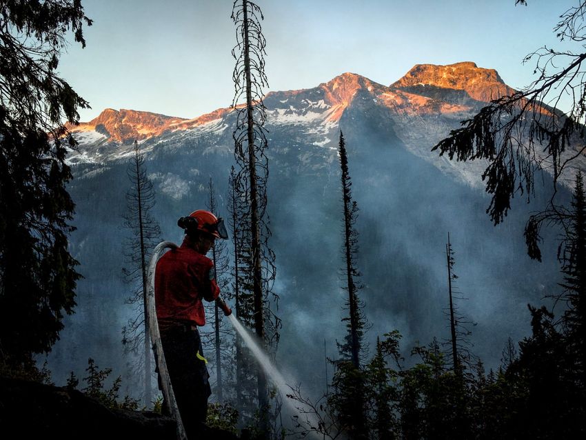
August 4, 2021
WILDFIRE UPDATE
Wildfires of Note in the Southeast Fire Centre include:
TROZZO CREEK (N51705)
Date of detection: July 9, 2021
Location: Originated 7.5 kilometres north-
east of Winlaw
Size: 5202 hectares
Status: Out of Control
Cause: Lightning
Resources: 115 personnel, 30 heavy
equipment, 3 helicopters
Fire camp in place: No
Fire update: Fire activity has remained
largely stable and general objectives the
same: contain the western flank from
Lemon Creek to Winlaw Creek, increase
containment depth in the Trozzo Creek
drainage, establish contingency guards
north and south of the fire and plan con-
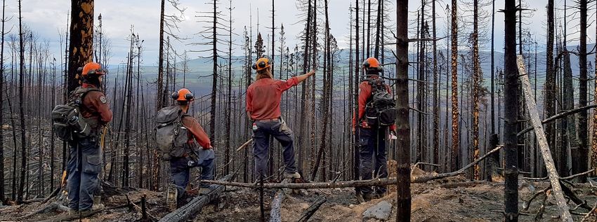
tainment guards for the south and east A firefighter actions a fire in this Southeast Fire Centre file photo.
flanks to implement once the western
flank is contained.
Weather is allowing for quicker progress along the western and northern flanks. Firefighters continue fire suppres-
sion along Elliot Anderson FSR and Lemon Creek FSR; mopping up; and building containment lines, constructing heli-
pads and cutting trails for access and egress in the upper Winlaw Creek area.
Heavy equipment continues guard construction and supporting ground crews. Helicopters continue to support
ground crews and conduct aerial monitoring. As of 10:40 on August 4, the fire had not crossed the Lemon Creek
FSR. Ongoing challenges include: lack of access to upper Winlaw Creek; lack of water resources at high elevations
and difficulties delivering by truck due to rough roads; steep, rocky and complex terrain; a high volume of dead and
downed trees; dense smoke that limits visibility and the ability for fixed-wing aircraft to access the fire.
Evacuations: The Regional District of Central Kootenay has downgraded an evacuation order to an evacuation alert
in the vicinity of this fire. Further information is available at https://www.rdck.ca
Other: An area restriction order is in effect in the vicinity of this fire. Further information is available at
www.bcwildfire.ca
Spot a wildfire, smoke or illegal fire activity? Call 1 800 663-5555 or *5555 on your cellphone.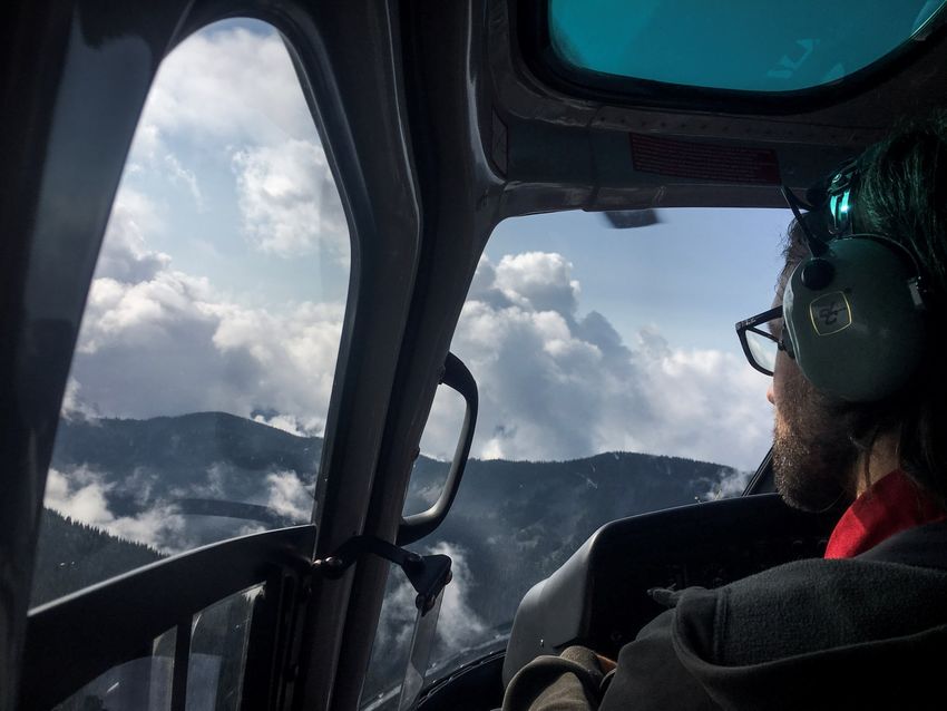
August 4, 2021

                  WILDFIRE UPDATE
BILL NYE MOUNTAIN (N11629)
Date of detection: July 8, 2021
Location: Originated 7 kilometres southeast of
Wasa
Size: 2990 hectares
Status: Out of Control
Cause: Lightning
Resources: 75 personnel, 2 heavy equipment, 1 hel-
icopter
Fire camp in place: No
Fire update: Fire behaviour remains low in cooler,
more humid weather conditions. On Wednesday,
ground crews are establishing new control lines on
the north flank and patrolling and mopping up on
the west flank in preparation for thermal imaging (a
drone scan) later this week. Helicopters continue to
conduct aerial monitoring of the fire and are availa-
ble to support ground crews with bucketing if need-
ed, though this is not anticipated under current
conditions. Heavy equipment continues to improve
control lines. Expect to see a reduction in the num-
ber of personnel working on this fire on Thursday as
objectives are completed and firefighters transition
out for rest and/or to work in other areas. Ongoing
challenges include: extreme slopes, heavy concen-
trations of fuel, poor access, poor visibility due to
heavy smoke/weather.                                  An August 3 map of the Bill Nye Mountain (N11629) wildfire that origi-
                                                           nated southeast of Wasa shows it at 2990 hectares.
Evacuations: The Regional District of East Kootenay
downgraded an evacuation order in the vicinity of
this fire to an evacuation alert. Further information is available at https://www.rdek.bc.ca/
Other: An area restriction order is in effect. Further information is available at www.bcwildfire.ca

      Spot a wildfire, smoke or illegal fire activity? Call 1 800 663-5555 or *5555 on your cellphone.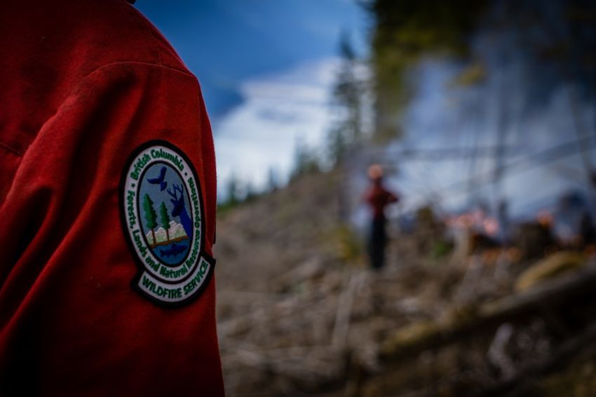
August 4, 2021

                    WILDFIRE UPDATE
AKOKLI CREEK (N71686)

Date of detection: July 9,
2021
Location: Originated 7 kilome-
tres east of Boswell
Size: 3140 hectares
Status: Out of control
Cause: Lightning
Resources: 25 personnel, 2
heavy equipment, 2 helicop-
ters
Fire camp in place: No
Fire Update: Crews continue
to patrol the fire above Bos-
well (west flank) and along
Akokli Creek (south flank). A
contingency guard is complet-
ed within Lockhart Park and
the fire is being monitored
above this guard. BCWS is
seeking out indirect attack
                                Helicopters are instrumental tools for monitoring fire size and behaviour and are widely used across the Southeast
opportunities to contain the Fire Centre, as seen in this file photo.
fire in this area. Heavy equip-
ment remains on standby and
helicopters are available to support crews in the event fire behaviour increases. No structures are currently threat-
ened.
Evacuations: The Regional District of Central Kootenay has implemented an evacuation alert in the vicinity of this
fire. Further information is available at https://www.rdck.ca
Other: An area restriction order is in effect. Further information is available at www.bcwildfire.ca

     EVACUATION ORDERS AND ALERTS ARE SUBJECT TO CHANGE. ALWAYS
      CONSULT YOUR REGIONAL DISTRICT FOR THE LATEST INFORMATION.

       Spot a wildfire, smoke or illegal fire activity? Call 1 800 663-5555 or *5555 on your cellphone.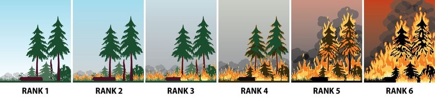
August 4, 2021

                     WILDFIRE UPDATE
The Arrow Lake Complex, comprised of the Octopus Creek, Michaud
Creek and Renata Creek wildfires, is being managed by an Incident
Management Team. Going forward, the Southeast Fire Centre will be
including brief updates on the two Wildfires of Note in the complex
(Octopus Creek and Michaud Creek) in the daily newsletter. If you
would like to receive the daily newsletter from the Arrow Lake Com-
plex information team, which includes more detailed updates, email
BCWS.ArrowLakeInfo@gov.bc.ca
The fires received a small amount of moisture overnight and early
Wednesday morning. There is a 50 per cent chance of thunderstorms
and scattered showers Wednesday morning. A mixture of sun and
cloud is expected in the afternoon with a 25 per cent chance of thun-
derstorms. Temperatures remain moderate at 27-28 with high hu-
midity. The smoke and higher humidity should help to reduce fire
activity and improve conditions of burnable surface fuels; however,
                                                                         OCTOPUS CREEK (N51800)
the larger fuels and deep soil remain highly combustible. Crews re-
port reduced fire activity. In spite of this, conditions can change rap- Date of detection: July 11, 2021
idly, and fire behaviour could increase suddenly.                        Location: Originated 11 kilometres south of Fauquier
MICHAUD LAKE (N51765)                                                   Size: 18,337 hectares (estimated)
Date of detection: July 10, 2021                                        Status: Out of Control
Location: Originated 21 kilometres south of Edgewood                    Cause: Lightning
Size: 8,847 hectares (estimated)                                        Resources: 90 personnel, 19 heavy equipment, 5 helicopters (shared
Status: Out of Control                                                  with two other fires in the Arrow Lake Complex)
Cause: Lightning                                                      Fire Update: The construction of the north flank line has been very
                                                                      successful. Firefighters and heavy equipment will continue to rein-
Resources: 66 personnel, 13 heavy equipment, 5 helicopters (shared
                                                                      force the control line built to protect the community of Fauquier
with two other fires in the Arrow Lake Complex)
                                                                      from the advancing wildfire. A small spot fire was located on the east
Fire Update: Good progress is being made by firefighters, who con- flank near Mista Peak. It’s estimated to be 0.2 ha in size and being
tinue to work on the control line north of the wildfire. Crews have   actioned by firefighters. Heavy equipment and crews at the east
established pumps and water hose from the lake and continue to        flank on Koch Creek are making good progress establishing control
work toward the west. The objective is to prevent the fire from       lines in the valley. This line is intended to prevent the wildfire from
growing toward the north/northwest. Firefighters continue to look     spreading east into adjacent valleys. The fire is slowly creeping each
for and extinguish spot fires across Johnson Creek with water and     day; however, the crews and equipment continue to reinforce the
hose along with helicopter assistance when visibility allows. Under   guards. Additional heavy equipment is planned to install new guard
the current weather conditions, firefighters anticipate they can con- in areas once the priority lines are set. Structure protection was es-
tain the spot fires. Firefighters have now begun to establish guard   tablished early on and is maintained and monitored by dedicated
line south of Michaud Creek, starting from the lake, with hand tools firefighters on properties that are threatened. The fire is very visible
and pump and hose. The majority of the wildfire has been inaccessi- from Edgewood, Fauquier, Needles and surrounding areas.
ble for rotary-wing due to smoke conditions; however, the wildfire is
                                                                      Evacuations: The Regional District of Central Kootenay has imple-
being monitored by satellite imagery. Planned control lines will be
                                                                      mented an evacuation order and an evacuation alert in the vicinity
constructed as soon as conditions allow.
                                                                      of this fire. Further information is available at https://www.rdck.ca/.
Evacuations: None. The latest information is available at https://    Other: An area restriction order is in effect. Further information is
www.rdck.ca/                                                          available at www.bcwildfire.ca
Other: An area restriction order is in effect. Further information is
available at www.bcwildfire.ca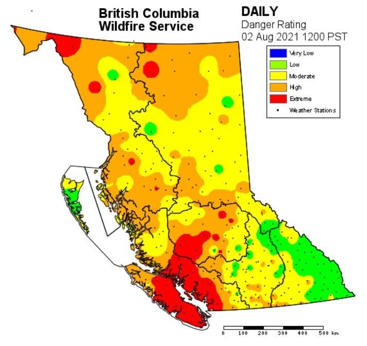
August 4, 2021
HELPFUL RESOURCES:
•     View an interactive map by clicking here or visiting http://ow.ly/uo2U30oXqzS
•     Road Closures: DriveBC |dial 1-800-550-4997 | https://www.drivebc.ca/
•     Drifting Smoke: www.bcairquality.ca/bluesky/west/index.html
•     Smoke Health Concerns: HealthLink BC | dial 8-1-1| www.healthlinkbc.ca/kbaltindex.asp
•     For info on Community Support Services, click here or visit https://www.emergencyinfobc.gov.bc.ca/

                                                   ROLES AND RESPONSIBILITIES
    BC Wildfire Service                   Emergency               Local municipalities and                 First Nations
                                        Management BC                regional districts
-   BCWS’s jurisdiction covers      - EMBC coordinates com-       -     Local Municipalities and     - On IR lands, Evacuation
    all BC Parks, Crown and           munication across all            Regional Districts speak        Orders and Alerts are
    private lands, but does not       agencies and stakeholders        directly about Strategic        implemented by a Band
    include the boundaries of         to support communities.          Evacuation Orders and           Council Resolution or
    local governments that                                             Alerts in their respective      other.
    have forest fire prevention     - EMBC provides advice to          jurisdictions.
    bylaws and are serviced by        evacuees and support to                                        - A designated person(s)
    a fire department.                communities regarding       -     Local Municipalities and       from the respective First
                                      Emergency Operations             Regional Districts do not       Nations community will
-   BCWS speaks directly about        Centres and Emergency            speak about the status of       speak to Evacuation
    wildfires (i.e. fire status,      Support Services.                a wildfire unless the fire      Orders and Alerts on IR
    operations, etc.) and is re-                                       occurs within their             lands.
    sponsible for disseminating                                        jurisdiction. For example,
    wildfire updates to local                                          if a wildfire starts within
    governments, stakeholders,                                         the boundaries of a local
    First Nations and the public.                                      government, BCWS will
                                                                       often assist the local fire
-   BCWS does not announce                                             department with
    Strategic Evacuation Orders                                        suppression efforts. If the
    or Alerts.                                                         fire spreads into Crown
                                                                       land to become a wildfire,
-   BCWS does announce                                                 BCWS will often assume
    Tactical Evacuations.                                              control.

-   In the event of an imminent
    threat to public safety,
    BCWS can authorize an im-
    mediate Tactical Evacuation
    of the affected area.

                                            ACCESSING INFORMATION
      BC Wildfire Service                          EmergencyInfoBC                                PreparednessBC
    Online Communications                    EMBC Online Communications                      EMBC Online Communications

            @BCGovFireInfo                           @EmergencyInfoBC                                 @PreparedBC

            www.bcwildfire.ca                        www.emergencyinfobc.gov.bc.ca                    www.gov.bc.ca/preparedBC

            BC Wildfire Service                      BCWS Mobile App                                  PreparedBC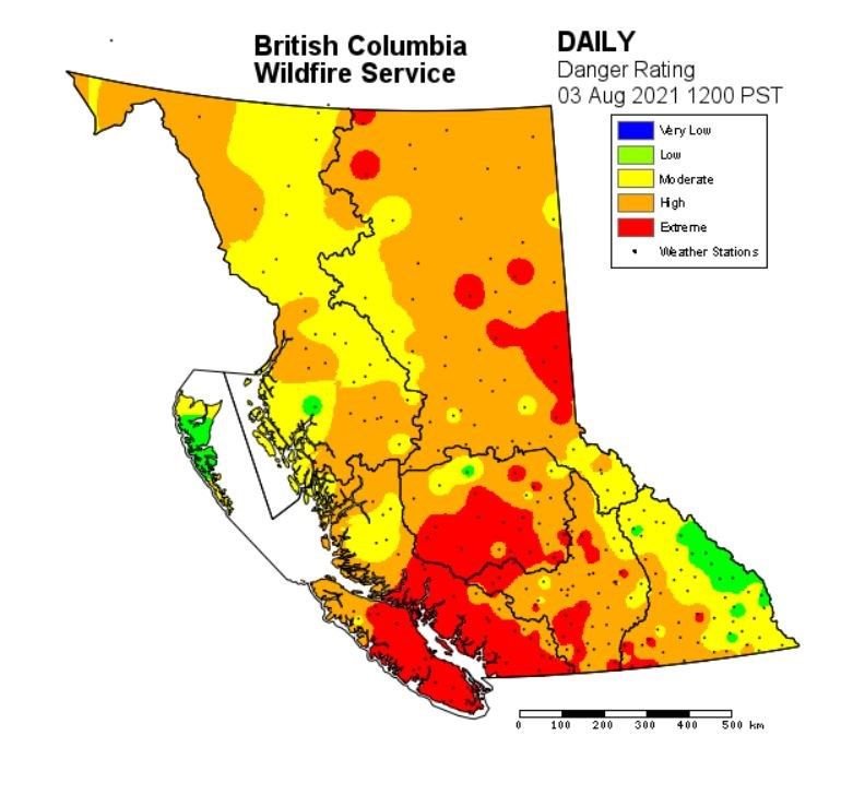
August 4, 2021
FIRE STAGES OF CONROL:
Out of Control       Describes a wildfire that is not responding (or only responding on a limited basis) to suppression action, such that the
                     perimeter spread is not being contained.

Being Held           Indicates that (with the resources currently committed to the fire) sufficient suppression action has been taken that the
                     fire is not likely to spread beyond existing or predetermined boundaries under the prevailing and forecasted conditions.
Under Control        The fire has received sufficient suppression action to ensure no further spread of the fire.

WILDFIRE RANKS:
Rank             Description
1                Characteristics: Smouldering ground fire, no open flame, white smoke, slow (i.e. creeping) rate of fire spread.
                 Firefighting tactics: Direct attack with ground crews using hand tools and water delivery systems (i.e. pumps and hose).

2                Characteristics: Surface fire, visible, open flame, unorganised or inconsistent flame front, slow rate of spread.
                 Firefighting tactics: Direct attack with ground crews using hand tools, water delivery systems, or heavy equipment. Hand
                 constructed control lines and lines that have been cleared of combustible material will likely be successful.

3                Characteristics: Organised flame front – fire progressing in organised manner, occasional candling may be observed along
                 the perimeter and/or within the fire, moderate rate of spread.
                 Firefighting tactics: Hand constructed control lines alone are likely to be challenged, ground crews conducting direct attack
                 may require air support from fixed-wing air tankers, skimmers or helicopters conducting bucketing or tanking operations.
                 Control lines constructed by heavy equipment will generally be effective
4                Characteristics: Grey to black smoke, organised surface flame front, moderate to fast rate of spread on the ground, short
                 aerial bursts through the forest canopy, short-range spotting.
                 Firefighting tactics: Ground operations may not be successful at the head of the fire, indirect tactics may be required to bring
                 the head of the fire under control. Parallel attack may be used along the flanks of the fire to direct the head into favourable
                 ground or fuels. Air operations may be required to support ground personnel.
5                Characteristics: Black to copper smoke, organised crown fire front, moderate to long-range spotting and spot fire growth.
                 Firefighting tactics: The limited options available include indirect attack and planned ignitions to remove fuel in the path of
                 this type of fire behaviour. Ground operations are often restricted to fighting the least active sections of the fire or con-
                 ducting ground ignition operations from secure control lines with readily available escape routes and safety zones.

6                Characteristics: Organised crown fire front, long-range spotting and independent spot fire growth, possible fireballs and
                 whirls, violent fire behaviour probable, a dominant smoke column may develop which influences fire behaviour.
                 Firefighting tactics: Firefighting under these conditions is extremely dangerous. Suppression efforts will be well away from
                 active fire behaviour and may include preparing structure protection measures or conducting indirect large-scale ignition
                 operations in an attempt to steer the fire. Often, the safest and most prudent strategy is to pull resources back to safe areas,
                 ensure that personnel and the general public are safe, and wait for fire behaviour to lessen before re-engaging in fire sup-
                 pression operations.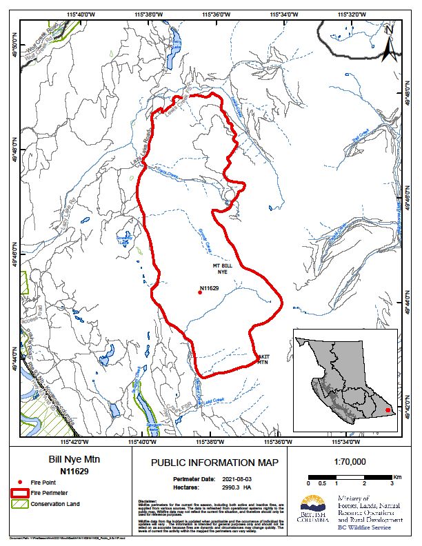
You can also read