WILDFIRE UPDATE - Regional District of East Kootenay
←
→
Page content transcription
If your browser does not render page correctly, please read the page content below
July 28, 2021

                     WILDFIRE UPDATE
Wildfires evolve rapidly and conditions can change extremely quickly.
Information in this bulletin is current as of noon on Wednesday, July 28.
For the latest information, go to BCWILDFIRE.CA
The Southeast Fire Centre is
responding to 66 active wild-
fires today. More resources
that arrived on incidents earli-
er this week have led to good
progress on a number of Wild-
fires of Note, but conditions
remain challenging.
Light winds are clearing smoke
in some parts of the fire cen-
tre, improving visibility and the
likelihood that fixed-wing air-               Working in steep terrain, as shown above, poses a number of safety challenges for firefighters.
craft—air tankers and skim-
mers—will be able to support
the ongoing work of ground
crews and helicopters. The
                                    The BC Wildfire Service dashboard map shows the boundary between the Kamloops Fire Centre and the Southeast Fire
clear skies, expected to last       Centre. Evacuation orders and alerts stretch across the boundary line.
through Thursday and Friday,
may also bring an increase in
fire activity in locations previously shaded by dense smoke and a slightly more unstable atmosphere may lead to higher
wind gust speeds in late afternoon, the peak of the daily burning period.
In the southwest of our fire centre, residents are being affected by the Nk’Mip Creek (K52061) wildfire burning in the Kam-
loops Fire Centre. The Kamloops Fire Centre (or KFC) is managing the response to this approximately 6,800-hectare fire but
areas under evacuation order and alert reach into the Southeast Fire Centre’s Boundary Fire Zone. Residents in the affect-
ed areas can follow updates on the Nk’Mip Creek wildfire on the Wildfire of Note page under the Kamloops Fire Centre
heading. The latest information on evacuation orders and alerts affecting residents of the Southeast Fire Centre is available
through the Regional District of Kootenay Boundary.

       EVACUATION ORDERS AND ALERTS ARE SUBJECT TO CHANGE. ALWAYS
        CONSULT YOUR REGIONAL DISTRICT FOR THE LATEST INFORMATION.

            www.bcwildfire.ca                   BC Forest Fire Info               @BCGovFireInfo                     www.firesmartbc.ca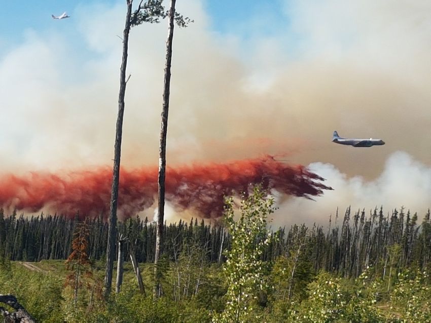
July 28, 2021
WILDFIRE UPDATE
Wildfires of Note in the Southeast Fire Centre include:
Trozzo Creek (N51705), Southeast Fire
Centre
Date of detection: July 9, 2021
Location: Originated 7.5 kilometres north-
east of Winlaw
Size: 3786 hectares
Status: Out of Control
Cause: Lightning
Resources: 90 personnel, 21 heavy equip-
ment, 5 helicopters
Fire camp in place: No
Fire Update: On Tuesday, light winds and
the lifting of dense smoke brought in-
creased fire activity along the Elliot Ridge.
Firefighters supported by helicopters
bucketing successfully contained an excur-
sion along the ridge above Perry Creek. As
of 20:00 on July 27, the fire had not
jumped the Lemon Creek FSR. Personnel
were able to map the fire Wednesday
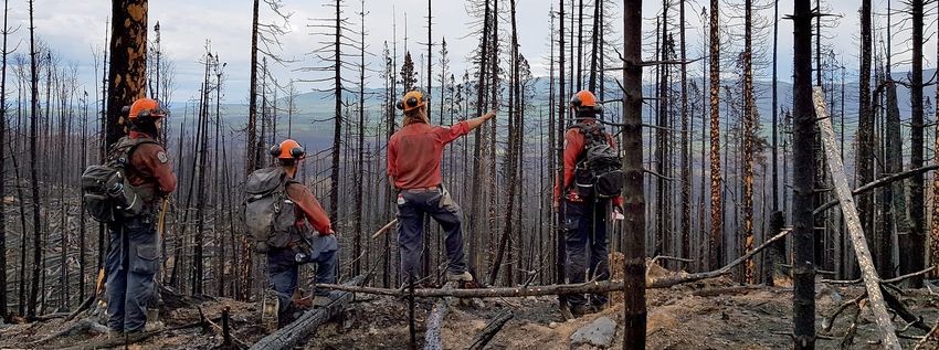
after the heavy smoke cleared and deter- Fixed-wing aircraft play an important role in supporting ground crews working to contain wildfires. In this
mine a more accurate perimeter, resulting file photo, an air tanker lays a line of fire retardant.
in the fire’s size being reduced from 4389
hectares to 3786 hectares.
A planned ignition to help control the fire's growth and spread is set to take place today near the five-kilometre mark on the
Trozzo Forest Service Road, provided conditions are suitable. Smoke columns will be visible in the area from Winlaw to Slocan.
The size of this planned ignition has been reduced from 50 hectares to 15 hectares as fire growth has already consumed fuels
in part of the area identified for the operation.
Crews are making good progress and have completed mopping up 15 metres deep along approximately five kilometres of the
fire’s edge in the Trozzo Creek drainage. Containment lines and contingency fuel breaks have been established around the El-
liot Anderson Forest Service Road over a six-kilometre stretch to prevent the fire from growing west and crews are working
along the ridge between North Fork Winlaw Creek and Winlaw Creek to establish helipads and suppress hot spots. Heavy
equipment is making good progress establishing a contingency guard from the Ponderosa FSR to the Dayton FSR.
Evacuations: An evacuation alert and an evacuation order implemented by the Regional District of Central Kootenay is in
effect. Further information is available at https://www.rdck.ca
Other: An area restriction order is in effect. Further information is available at www.bcwildfire.ca
Spot a wildfire, smoke or illegal fire activity? Call 1 800 663-5555 or *5555 on your cellphone.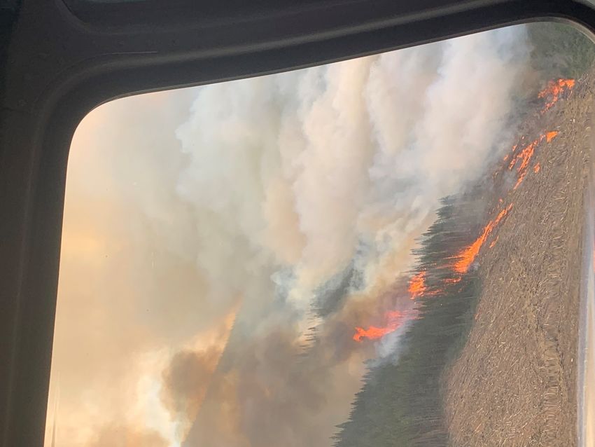
July 28, 2021

                  WILDFIRE UPDATE
Bill Nye Mountain (N11629), Southeast Fire Centre
Date of detection: July 8, 2021
Location: Originated 7 kilometres southeast of Wasa
Size: 1918 hectares (estimated)
Status: Out of Control
Cause: Lightning
Resources: 40 personnel, 4 heavy equipment, 2 helicopters
Fire camp in place: No
Fire Update: On Tuesday evening, wind and terrain increased fire behaviour on the north flank, where planned ignitions on
July 25 could not be completed, and caused the fire to move downslope toward Lazy Lake Road. This prompted an expansion
of an evacuation order for properties in the area. While structures are not immediately threatened, the BC Wildfire Service
recommended the evacuation order due to the potential for the Lazy Lake Road to be impacted, which would affect access
and egress to these properties.
Fire behaviour on the western flank of the fire, where the July 25 planned ignition was successfully completed, has not seen a
significant change.
Control lines are being laid out and constructed to the north of the fire to protect structures and build toward containment.
Helicopters will continue bucketing to support ground crews. Aerial monitoring of the fire is ongoing. Heavy equipment is con-
structing a machine guard along the west and north flank and around structures.
Evacuations: The Regional District of East Kootenay has an evacuation order and an evacuation alert in effect in the vicinity of
this fire. Further information is available at https://www.rdek.bc.ca/
Other: An area restriction order is in effect. Further information is available at www.bcwildfire.ca

Mineral Creek (N22147), Southeast Fire Centre
Date of detection: July 2, 2021
Location: Originated 25 kilometres southwest of Invermere
Size: 103 hectares
Status: Out of control
Cause: Unknown
Resources: 32 personnel, 3 heavy equipment, 2 helicopters
Fire camp in place: No
Fire Update: Work continues today to complete the wet line along the south flank. A wetline is comprised of hose or sprinklers
that are strategically placed along a control line to keep consistent moisture and humidity in the area. Ground crews will also
be intentionally burning a small amount of fuel on the south flank to additionally reinforce that guard. Work will continue on a
hand-built fuel-free guard in the slide chute where it is too steep for machines to operate and retardant will be laid down to
reinforce that fuel-free.
Work begins to prepare the area for a small, approximately 20-hectare planned ignition in the northeast corner of the fire that
will bring the fire down to more workable terrain. This planned ignition will begin on or around July 29, depending on suitable

      Spot a wildfire, smoke or illegal fire activity? Call 1 800 663-5555 or *5555 on your cellphone.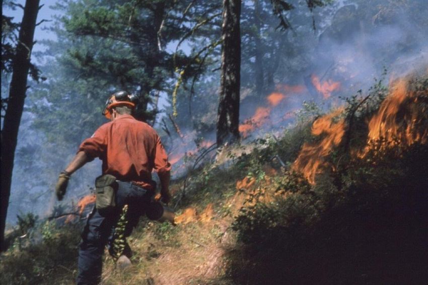
July 28, 2021

                   WILDFIRE UPDATE
conditions. Helicopters will bucket to help cool pieces of the fire
as required.
Evacuations: None as of 0900 July 27. For the latest information
on evacuation orders and alerts, visit https://www.rdek.bc.ca/
Other: An area restriction is in effect. Further information is avail-
able at www.bcwildfire.ca

Akokli Creek (N71686), Southeast Fire Centre
Date of detection: July 9, 2021
Location: Originated 7 kilometres east of Boswell
Size: 2249 hectares (estimated)
Status: Out of control
Cause: Lightning
Resources: 54 personnel, 4 heavy equipment, 3 helicopters
Fire camp in place: No
Fire Update: The fire remains very active and is highly visible
from Boswell, Creston and surrounding areas, as well as to those
travelling along Hwy 3A. Crews continue small-scale ignitions to
ease the fire to the control line where it can be suppressed. Fire-
fighters are working northward along the control line to secure
the fire up to the Lockhart Park boundary. Helicopters are sup-
porting ground crews with bucketing. Heavy equipment contin-
ues line construction and crews are extending hose lays to the
north toward Lockhart, which is now almost complete. Planning
is underway for a control line closer to private land in the event
that already established lines are breached. A structure protec-
                                                                         The Mineral Creek (N22147) wildfire, pictured on July 23, is burning in steep
tion specialist is on site completing an assessment of the area
                                                                         ground southwest of Invermere. The mountainous terrain of the Southeast
and devising a plan to protect structures should they be immi-
                                                                         Fire Centre presents challenges for firefighters working to contain wildfires.
nently threatened. Crews continue to monitor the fire 24 hours a
day. As of 0900 July 28, the fire remained within the planned            How to find out about wildfires if you don’t have Internet ac-
containment area. Conditions permitting, fixed-wing skimmers             cess:
and air tankers remain at the ready to respond to this fire if the       You can find out lots about wildfires of information on BCWild-
need arises.                                                             fire.ca and from the BCWildfire service app. But what do you do if
Evacuations: The Regional District of Central Kootenay has imple-        you don’t have Internet or a smart phone?
mented an evacuation alert in the vicinity of this fire. Further in-     The BC Wildfire service maintains a public line that allows people
formation is available at https://www.rdck.ca/EN/index.html              to seek information by fire centre. The number is 1 888 3FOREST
Other: An area restriction order is in effect. Further information       (1 888 336-7378). While this will not give you the detail available
is available at www.bcwildfire.ca                                        online, it gives a brief update on the Fire Centre’s Fires of Note as
                                                                         well as the danger class.

      Spot a wildfire, smoke or illegal fire activity? Call 1 800 663-5555 or *5555 on your cellphone.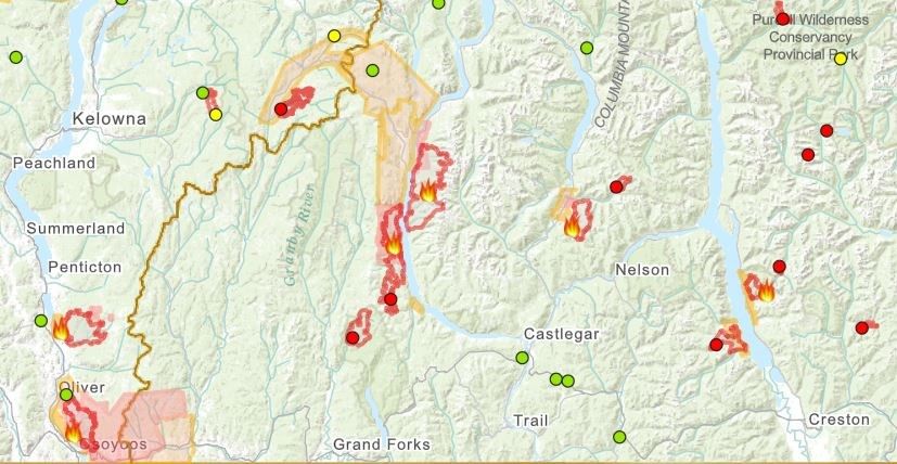
July 28, 2021

                      WILDFIRE UPDATE
All about planned ignitions:
Essential and effective tac-
tics that the BC Wildfire
Service use to help contain
very large wildfires include
burn operations. Burn op-
erations are sometimes
referred to as “planned
ignitions,” “burn-offs,”
“burn-outs” or “backfiring.”
When the decision is made
to conduct such a burn op-
eration, the wildfire is usu-
ally beyond the initial
attack stage. Whether the
BC Wildfire Service is burn-
ing out, burning off or back-
firing, the goal is always the
same: to remove the ma-
jority of available fuel
ahead of the wildfire so
there’s less fuel available
for the wildfire to burn.
This strategy slows down
                               A BC Wildfire Service crew member uses a hand torch to undertake a planned ignition. Planned ignitions are a useful tactic to
and helps limit the spread
                               control large wildfires in some circumstances by removing fuel, helping to direct wildfires away from structures and/or popu-
of the wildfire.               lated areas and reducing the area that requires suppression efforts. These operations will take place on several of the wildfires
The first priority with these burning in the Southeast Fire Centre.
operations is always safety.
Planned ignitions must provide for the safety of personnel, the public, equipment and nearby values (e.g. homes, infrastruc-
ture, natural resources). The ignition plan must also identify, assess and mitigate potential hazards. Large-scale burn opera-
tions are supported with appropriate resources, such as aircraft, heavy equipment and firefighters.

      EVACUATION ORDERS AND ALERTS ARE SUBJECT TO CHANGE. ALWAYS
       CONSULT YOUR REGIONAL DISTRICT FOR THE LATEST INFORMATION.

       Spot a wildfire, smoke or illegal fire activity? Call 1 800 663-5555 or *5555 on your cellphone.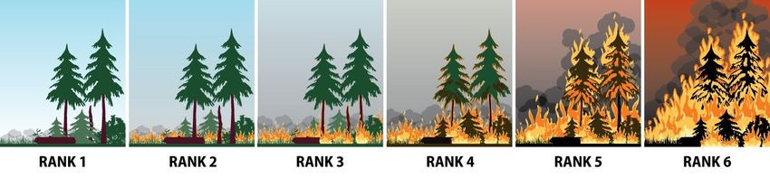
July 28, 2021
HELPFUL RESOURCES:
•     View an interactive map by clicking here or visiting http://ow.ly/uo2U30oXqzS
•     Road Closures: DriveBC |dial 1-800-550-4997 | https://www.drivebc.ca/
•     Drifting Smoke: www.bcairquality.ca/bluesky/west/index.html
•     Smoke Health Concerns: HealthLink BC | dial 8-1-1| www.healthlinkbc.ca/kbaltindex.asp
•     For info on Community Support Services, click here or visit https://www.emergencyinfobc.gov.bc.ca/

                                                   ROLES AND RESPONSIBILITIES
    BC Wildfire Service                   Emergency               Local municipalities and                 First Nations
                                        Management BC                regional districts
-   BCWS’s jurisdiction covers      - EMBC coordinates com-       -     Local Municipalities and     - On IR lands, Evacuation
    all BC Parks, Crown and           munication across all            Regional Districts speak        Orders and Alerts are
    private lands, but does not       agencies and stakeholders        directly about Strategic        implemented by a Band
    include the boundaries of         to support communities.          Evacuation Orders and           Council Resolution or
    local governments that                                             Alerts in their respective      other.
    have forest fire prevention     - EMBC provides advice to          jurisdictions.
    bylaws and are serviced by        evacuees and support to                                        - A designated person(s)
    a fire department.                communities regarding       -     Local Municipalities and       from the respective First
                                      Emergency Operations             Regional Districts do not       Nations community will
-   BCWS speaks directly about        Centres and Emergency            speak about the status of       speak to Evacuation
    wildfires (i.e. fire status,      Support Services.                a wildfire unless the fire      Orders and Alerts on IR
    operations, etc.) and is re-                                       occurs within their             lands.
    sponsible for disseminating                                        jurisdiction. For example,
    wildfire updates to local                                          if a wildfire starts within
    governments, stakeholders,                                         the boundaries of a local
    First Nations and the public.                                      government, BCWS will
                                                                       often assist the local fire
-   BCWS does not announce                                             department with
    Strategic Evacuation Orders                                        suppression efforts. If the
    or Alerts.                                                         fire spreads into Crown
                                                                       land to become a wildfire,
-   BCWS does announce                                                 BCWS will often assume
    Tactical Evacuations.                                              control.

-   In the event of an imminent
    threat to public safety,
    BCWS can authorize an im-
    mediate Tactical Evacuation
    of the affected area.

                                            ACCESSING INFORMATION
      BC Wildfire Service                          EmergencyInfoBC                                PreparednessBC
    Online Communications                    EMBC Online Communications                      EMBC Online Communications

            @BCGovFireInfo                           @EmergencyInfoBC                                 @PreparedBC

            www.bcwildfire.ca                        www.emergencyinfobc.gov.bc.ca                    www.gov.bc.ca/preparedBC

            BC Wildfire Service                      BCWS Mobile App                                  PreparedBC
July 28, 2021
FIRE STAGES OF CONROL:
Out of Control Describes a wildfire that is not responding (or only responding on a limited basis) to suppression action, such that the
perimeter spread is not being contained.
Being Held Indicates that (with the resources currently committed to the fire) sufficient suppression action has been taken that the
fire is not likely to spread beyond existing or predetermined boundaries under the prevailing and forecasted conditions.
Under Control The fire has received sufficient suppression action to ensure no further spread of the fire.
WILDFIRE RANKS:
Rank Description
1 Characteristics: Smouldering ground fire, no open flame, white smoke, slow (i.e. creeping) rate of fire spread.
Firefighting tactics: Direct attack with ground crews using hand tools and water delivery systems (i.e. pumps and hose).
2 Characteristics: Surface fire, visible, open flame, unorganised or inconsistent flame front, slow rate of spread.
Firefighting tactics: Direct attack with ground crews using hand tools, water delivery systems, or heavy equipment. Hand
constructed control lines and lines that have been cleared of combustible material will likely be successful.
3 Characteristics: Organised flame front – fire progressing in organised manner, occasional candling may be observed along
the perimeter and/or within the fire, moderate rate of spread.
Firefighting tactics: Hand constructed control lines alone are likely to be challenged, ground crews conducting direct attack
may require air support from fixed-wing air tankers, skimmers or helicopters conducting bucketing or tanking operations.
Control lines constructed by heavy equipment will generally be effective
4 Characteristics: Grey to black smoke, organised surface flame front, moderate to fast rate of spread on the ground, short
aerial bursts through the forest canopy, short-range spotting.
Firefighting tactics: Ground operations may not be successful at the head of the fire, indirect tactics may be required to bring
the head of the fire under control. Parallel attack may be used along the flanks of the fire to direct the head into favourable
ground or fuels. Air operations may be required to support ground personnel.
5 Characteristics: Black to copper smoke, organised crown fire front, moderate to long-range spotting and spot fire growth.
Firefighting tactics: The limited options available include indirect attack and planned ignitions to remove fuel in the path of
this type of fire behaviour. Ground operations are often restricted to fighting the least active sections of the fire or con-
ducting ground ignition operations from secure control lines with readily available escape routes and safety zones.
6 Characteristics: Organised crown fire front, long-range spotting and independent spot fire growth, possible fireballs and
whirls, violent fire behaviour probable, a dominant smoke column may develop which influences fire behaviour.
Firefighting tactics: Firefighting under these conditions is extremely dangerous. Suppression efforts will be well away from
active fire behaviour and may include preparing structure protection measures or conducting indirect large-scale ignition
operations in an attempt to steer the fire. Often, the safest and most prudent strategy is to pull resources back to safe areas,
ensure that personnel and the general public are safe, and wait for fire behaviour to lessen before re-engaging in fire sup-
pression operations.You can also read