WILDFIRE UPDATE EVACUATION ORDERS AND ALERTS ARE SUBJECT TO CHANGE. ALWAYS CONSULT YOUR REGIONAL DISTRICT FOR THE LATEST INFORMATION - Village of ...
←
→
Page content transcription
If your browser does not render page correctly, please read the page content below
July 25, 2021
WILDFIRE UPDATE
EVACUATION ORDERS AND ALERTS ARE SUBJECT TO CHANGE. ALWAYS
CONSULT YOUR REGIONAL DISTRICT FOR THE LATEST INFORMATION.
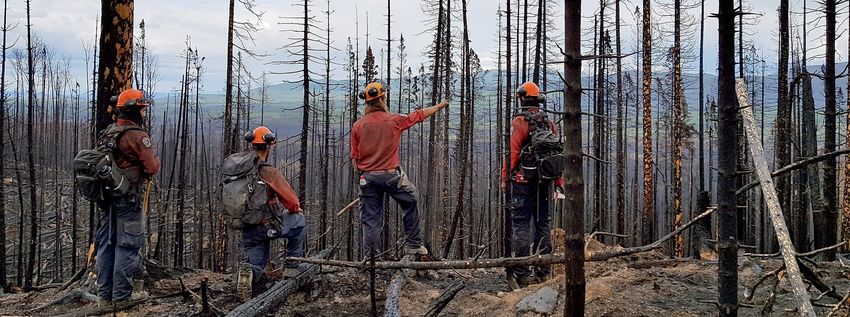
The Southeast Fire Centre is currently responding to 67 active fires. Most of these fires were caused by lightning that moved
through the area a week ago. We are still picking up new fires that have been burning underground and are now starting to
show.
There are currently 441 personnel working on the fires within the Southeast Fire Centre. They come from this fire centre and
other fire centres in BC, from various government ministries, local forest industry, contractors and other organizations. An Inci-
dent Management Team from Alberta is leading the response to the newly formed Arrow Lake Complex, which includes the Oc-
topus Creek, Michaud Creek and Renata Creek wildfires in the Arrow Valley.
Wildfires of Note in the Southeast Fire Centre include:
Trozzo Creek (N51705), Southeast Fire Centre
Date of detection: July 9, 2021
Location: Originated 7.5 kilometres northeast of Winlaw,
Size: 4389 hectares (estimated)
Status: Out of Control
Cause: Lightning
Resources: 90 personnel, 17 heavy equipment, 5 helicopters
Objectives: Ground crews and heavy equipment continue to build fire guards up the Elliot Forest Service Road to prevent fire spread into
Elliot Creek. Crews are laying hoses and sprinklers and identifying areas where they can conduct small burnouts to prevent fire spread. Heli-
copters are bucketing to support ground crews. Crews continue work to hold current containment lines on the west perimeter in the Trozzo
Creek drainage while also monitoring fire growth toward the east (Baldface Creek) and south (Sproule Creek). They continue to scout and
locate guard construction options for north of Lemon Creek, utilizing forestry road systems, in anticipation of further growth to the north.
Evacuations: An evacuation order and an evacuation alert implemented by the Regional District of Central Kootenay are in effect. Further
information is available at https://www.rdck.ca
Other: An area restriction is in effect. Further information is available at www.bcwildfire.ca
Bill Nye Mountain (N11629), Southeast Fire Centre
Date of detection: July 8, 2021
Location: Originated 7 kilometres southeast of Wasa
Size: 1107 hectares (estimated)
Status: Out of Control
Cause: Lightning
Resources: 8 personnel, 2 heavy equipment, 3 helicopters
Objectives: A planned ignition was partly completed on Sunday morning. In the southern part of the area identified for the planned ignition,
the operation was a success. Due to increased fire activity in the north part of the area, planned ignitions were halted. Ground crews contin-
ue to build control lines along the base of the slope and up the sides as far as possible—steep, unstable terrain makes some areas inaccessi-
www.bcwildfire.ca BC Forest Fire Info @BCGovFireInfo www.firesmartbc.ca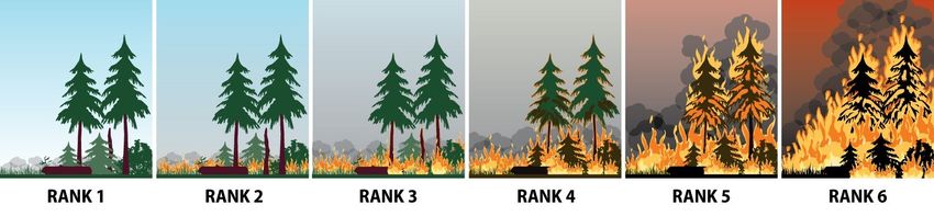
July 25, 2021

                    WILDFIRE UPDATE
ble. Helicopters are dropping water on the fire to support the work of firefighters on the ground.
Evacuations: The Regional District of East Kootenay has an evacuation order and an evacuation alert in effect in the vicinity of this fire. The
latest information is available at https://www.rdek.bc.ca/
Other: An area restriction is in effect. Further information is available at www.bcwildfire.ca

Cultus Creek (N71245), Southeast Fire Centre
Date of detection: July 2, 2021
Location: Originated 35 km kilometres southeast of Nelson
Size: 2665 hectares (estimated)
Status: Out of control
Cause: Lightning
Resources: 9 personnel, 0 heavy equipment, 1 helicopter
Objectives: Crews made excellent progress suppressing the fire in the Tye area, where a number of cabins are located. As a result, an evac-
uation order that was in effect was reduced to an evacuation alert today.
Evacuation: The Regional District of Central Kootenay has an evacuation alert in effect. Further information is available at https://
www.rdck.ca/ This fire will be removed from our Fire of Note page tomorrow.

Mineral Creek (N22147), Southeast Fire Centre
Date of detection: July 2, 2021
Location: Originated 25 kilometres southwest of Invermere
Size: 34 hectares
Status: Out of control
Cause: Unknown
Resources: 5 personnel, 3 heavy equipment, 1 helicopter
Objectives: Crews are conducting a direct attack on the lower flank of the fire, using heavy equipment to tie in the existing road network to
anchor points.
Evacuations: None as of 1700 on July 25.
Other: An area restriction is in effect. The latest information is available at www.bcwildfire.ca

Akokli Creek (N71686), Southeast Fire Centre
Date of detection: July 9, 2021
Location: Originated 7 kilometres east of Boswell
Size: 1912 hectares (estimated)
Status: Out of control
Cause: Lightning
Resources: 40 personnel, 4 heavy equipment, 4 helicopters
Objectives: Crews are working to build a contingency line with assistance from heavy equipment and helicopters. The firefighters are rein-
forcing and mopping up the fire along the heavy equipment guard from the Akokli Creek drainage on to the western aspect where the fire
has come close to the containment line. A heavy equipment guard has been constructed from the Akokli Creek drainage northward past

       Spot a wildfire, smoke or illegal fire activity? Call 1 800 663-5555 or *5555 on your cellphone.
July 25, 2021
WILDFIRE UPDATE
McGregor Creek to Holiday Creek. The fire is predominantly northward along the ridgetop and is highly visible along the highway corridor
including Boswell, Creston and surrounding areas as well as those travelling along Hwy 3A.
Evacuations: The Regional District of Central Kootenay has implemented an evacuation alert. Further information is available at https://
www.rdck.ca/EN/index.html
Other: An area restriction is in effect. Further information is available at www.bcwildfire.ca
The Arrow Lake Complex includes the Octopus Creek, Michaud Creek and Renata Creek wildfires. Brief updates
for these three fires follow. After today, daily updates for these fires will only be coming from the Arrow Lake
Complex team. If you are not receiving updates from the Arrow Lake Complex and would like to, please email
BCWS.ArrowLakeINFO@gov.bc.ca and ask to be included on the mailing list.
Octopus Creek (N51800), Southeast Fire Centre
Date of detection: July 11, 2021
Location: Originated 11 kilometres south of Fauquier
Size: 11,444 hectares (estimated)
Status: Out of Control
Cause: Lightning
Resources: 21 personnel, 4 heavy equipment, 1 helicopter
Objectives: Crews are focusing on establishing containment lines in priority areas. They are concentrating on the north flank and will move
to the south flank once visibility allows for aircraft. The fire is very visible from Edgewood, Fauquier, Needles and surrounding areas.
Evacuations: The Regional District of Central Kootenay has issued an evacuation order in the vicinity of this fire. Further information is
available at https://www.rdck.ca/
Other: An area restriction is in effect. Further information is available at www.bcwildfire.ca
Michaud Creek (N51765), Southeast Fire Centre
Date of detection: July 10, 2021
Location: Originated 21 kilometres south of Edgewood
Size: 4,600 hectares (estimated)
Status: Out of Control
Cause: Lightning
Resources: 2 personnel, 20 heavy equipment, 0 helicopters
Objectives: As of this morning, the fire remained south of Johnson Creek and was holding at the established control lines and an area of an
old burn as of yesterday. Fire behaviour has dropped due to the lessening winds. Smoke in the area is blocking the sun, which has lowered
temperatures; however, smoke is impeding air support operations. Crews will continue to anchor where possible with heavy equipment
and personnel. Crews are focusing on establishing containment lines in priority areas which include the north flank to limit the growth to
the N-NW. A 15-person IMT from Alberta is now established and currently configuring an ICP in Nakusp. The Arrow Lake Complex will man-
age the Octopus Creek (N51705) fire, the Michaud Creek (N51765) fire and the Renata Creek (N51688).
Evacuations: The Regional District of Central Kootenay has an evacuation order and an evacuation alert in effect in the vicinity of this fire.
Further information is available at https://www.rdck.ca/
Other: An area restriction order is in effect. Further information is available at www.bcwildfire.ca
Spot a wildfire, smoke or illegal fire activity? Call 1 800 663-5555 or *5555 on your cellphone.July 25, 2021
WILDFIRE UPDATE
Smoke
Smoke has two major impacts on firefighting.
The negative impact is to aircraft operations. Helicopters and air tankers fly very low to the ground and must have clear lines of sight to fly.
The pilots are required by Navigation Canada to monitor visibility and will inform us when it is not safe for them to work.
The positive impact smoke has in the fire environment is that it acts as an umbrella, shielding the ground from the heating effect of the
sun’s rays. Air temperature is often less than it would be without the smoke, and lower temperatures can reduce fire activity.
FireSmoke Canada is a website that provides smoke forecasts (link) and provides hourly forecasts for smoke particles from wildfires up to
two days in the future. The current smoke in the Southeast Fire Centre is a blend of smoke from the fires in the Kamloops and Southeast
fire centres, as well as from fires in the United States.
Helicopter Use
Although helicopters are important tools in our fire suppression arsenal, they cannot put out wildfires on their own. Helicopters support
crews and other firefighting resources on the ground. They perform many different tasks, such as dropping water on “hot spots,” trans-
porting personnel to and from the fireline and giving BC Wildfire Service staff an aerial view of a wildfire.
It is unsafe to operate helicopters near a wildfire at night, so these aircraft only fly during daylight hours. This is a simple matter of safety,
both for helicopter crews and people on the ground. Pilots working for the BC Wildfire Service can work a maximum of 12 duty hours under
Transport Canada legislation, which includes a general maximum of eight operational flight hours and a mandatory eight hours rest. These
regulations can be legally exceeded if fire activity necessitates. To minimize fatigue to the pilots, BC Wildfire Service avoids this unless re-
quired.
Retardant
Fire retardants, foams and water can be used to slow a fire. These substances are not used to put out fires, but rather to cool them and
slow their progress. This supports the efforts of ground crews in containing the fire.
Water soluble retardants are used most commonly in fire suppression because of their long-lasting effect on fires. They contain ammonium
salts, which effect the burning process of forest fuels. Retardants prematurely release the gaseous fuels within logs and debris. This reac-
tion releases a water and carbon dioxide combination that cools and suffocates the fire.
The retardant used in BC comes from a company called Perimeter Solutions and is called Phos Chek. More information about the product
can be found on the company website (link).
In BC, the retardant we use is Phos Check LC95A, and for those of you without Internet access, the following text is from the company’s
website: “Functionally, PHOS-CHEK LC95 series fire retardants react with and alter the thermal decomposition of wildland fuels so that they
do not support flaming or glowing combustion. This deprives the fire of fuel, reducing fire intensity and the rate of combustion and flame
spread. PHOS-CHEK LC95A-Fx is colored (with Red Iron Oxide) to provide effective aerial application. These gum-thickened PHOS-CHEK re-
tardants reduce drift and evaporation and increases fuel coverage, wrap around and penetration through canopy and ladder fuels.”
Spot a wildfire, smoke or illegal fire activity? Call 1 800 663-5555 or *5555 on your cellphone.July 25, 2021
HELPFUL RESOURCES:
• View an interactive map by clicking here or visiting http://ow.ly/uo2U30oXqzS
• Road Closures: DriveBC |dial 1-800-550-4997 | https://www.drivebc.ca/
• Drifting Smoke: www.bcairquality.ca/bluesky/west/index.html
• Smoke Health Concerns: HealthLink BC | dial 8-1-1| www.healthlinkbc.ca/kbaltindex.asp
• For info on Community Support Services, click here or visit https://www.emergencyinfobc.gov.bc.ca/
ROLES AND RESPONSIBILITIES
BC Wildfire Service Emergency Local municipalities and First Nations
Management BC regional districts
- BCWS’s jurisdiction covers - EMBC coordinates com- - Local Municipalities and - On IR lands, Evacuation
all BC Parks, Crown and munication across all Regional Districts speak Orders and Alerts are
private lands, but does not agencies and stakeholders directly about Strategic implemented by a Band
include the boundaries of to support communities. Evacuation Orders and Council Resolution or
local governments that Alerts in their respective other.
have forest fire prevention - EMBC provides advice to jurisdictions.
bylaws and are serviced by evacuees and support to - A designated person(s)
a fire department. communities regarding - Local Municipalities and from the respective First
Emergency Operations Regional Districts do not Nations community will
- BCWS speaks directly about Centres and Emergency speak about the status of speak to Evacuation
wildfires (i.e. fire status, Support Services. a wildfire unless the fire Orders and Alerts on IR
operations, etc.) and is re- occurs within their lands.
sponsible for disseminating jurisdiction. For example,
wildfire updates to local if a wildfire starts within
governments, stakeholders, the boundaries of a local
First Nations and the public. government, BCWS will
often assist the local fire
- BCWS does not announce department with
Strategic Evacuation Orders suppression efforts. If the
or Alerts. fire spreads into Crown
land to become a wildfire,
- BCWS does announce BCWS will often assume
Tactical Evacuations. control.
- In the event of an imminent
threat to public safety,
BCWS can authorize an im-
mediate Tactical Evacuation
of the affected area.
ACCESSING INFORMATION
BC Wildfire Service EmergencyInfoBC PreparednessBC
Online Communications EMBC Online Communications EMBC Online Communications
@BCGovFireInfo @EmergencyInfoBC @PreparedBC
www.bcwildfire.ca www.emergencyinfobc.gov.bc.ca www.gov.bc.ca/preparedBC
BC Wildfire Service BCWS Mobile App PreparedBCJuly 25, 2021
FIRE STAGES OF CONROL:
Out of Control Describes a wildfire that is not responding (or only responding on a limited basis) to suppression action, such that the
perimeter spread is not being contained.
Being Held Indicates that (with the resources currently committed to the fire) sufficient suppression action has been taken that the
fire is not likely to spread beyond existing or predetermined boundaries under the prevailing and forecasted conditions.
Under Control The fire has received sufficient suppression action to ensure no further spread of the fire.
WILDFIRE RANKS:
Rank Description
1 Characteristics: Smouldering ground fire, no open flame, white smoke, slow (i.e. creeping) rate of fire spread.
Firefighting tactics: Direct attack with ground crews using hand tools and water delivery systems (i.e. pumps and hose).
2 Characteristics: Surface fire, visible, open flame, unorganised or inconsistent flame front, slow rate of spread.
Firefighting tactics: Direct attack with ground crews using hand tools, water delivery systems, or heavy equipment. Hand
constructed control lines and lines that have been cleared of combustible material will likely be successful.
3 Characteristics: Organised flame front – fire progressing in organised manner, occasional candling may be observed along
the perimeter and/or within the fire, moderate rate of spread.
Firefighting tactics: Hand constructed control lines alone are likely to be challenged, ground crews conducting direct attack
may require air support from fixed-wing air tankers, skimmers or helicopters conducting bucketing or tanking operations.
Control lines constructed by heavy equipment will generally be effective
4 Characteristics: Grey to black smoke, organised surface flame front, moderate to fast rate of spread on the ground, short
aerial bursts through the forest canopy, short-range spotting.
Firefighting tactics: Ground operations may not be successful at the head of the fire, indirect tactics may be required to bring
the head of the fire under control. Parallel attack may be used along the flanks of the fire to direct the head into favourable
ground or fuels. Air operations may be required to support ground personnel.
5 Characteristics: Black to copper smoke, organised crown fire front, moderate to long-range spotting and spot fire growth.
Firefighting tactics: The limited options available include indirect attack and planned ignitions to remove fuel in the path of
this type of fire behaviour. Ground operations are often restricted to fighting the least active sections of the fire or con-
ducting ground ignition operations from secure control lines with readily available escape routes and safety zones.
6 Characteristics: Organised crown fire front, long-range spotting and independent spot fire growth, possible fireballs and
whirls, violent fire behaviour probable, a dominant smoke column may develop which influences fire behaviour.
Firefighting tactics: Firefighting under these conditions is extremely dangerous. Suppression efforts will be well away from
active fire behaviour and may include preparing structure protection measures or conducting indirect large-scale ignition
operations in an attempt to steer the fire. Often, the safest and most prudent strategy is to pull resources back to safe areas,
ensure that personnel and the general public are safe, and wait for fire behaviour to lessen before re-engaging in fire sup-
pression operations.You can also read